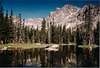
Elk Tooth Overview
![]() Elk Tooth-photo by Brenta
Elk Tooth-photo by Brenta
This secluded mountain resides directly on the southern boundary of Rocky Mountain National Park and on the northern boundary of the Indian Peak Wilderness. Unlike many of the peaks in the Indian Peak Wilderness, Elk Tooth (12,868 ft.) is not frequently visited. I would consider this mountain to be as remote one can get while approaching the IPW from the east(Denver side.) It is highly probable that you will be the only one on this mountain. Elk Tooth's summit registry has resided on the summit since 1987, and its lid unscrews maybe 10 times a year. This mountain has a luring appeal to it, most likely because the summit never leaves your view on the approach up the Middle St Vrain Drainage. For those willing to spend the time and effort climbing it, Elk Tooth will delivers a sublime wilderness experience.
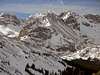
The standard East Ridge Route involves some fun class 3 scrambling on decent rock. The route also requires solid route-finding skills, and lastly, a very long approach.
Overall the hike is 18 miles round trip and is divided into two segments. The first 4.5 mile segment starts at the Middle St.Vrain Trailhead (8,680 ft.) and follows a rough 4wd. road to the Middle St. Vrain Wilderness Boundary (9,730 ft.) Do not try driving this road unless your vehicle has high clearance and 4wd. It will take you approximately an hour and a half to drive 4.5 miles. Once at the wilderness boundary, the second 9-mile round- trip segment starts.
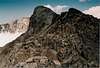
Gully from Hell!!
Author: kisters_0
Date: Nov 01, 2002 10:08 AM
Beware that an early morning start is most recommended. This gully can be a nightmare and if others happen to be ahead of you look out for falling rock. A helmet is strongly recommended and a sick sense of humor too. If in a group travel close together to minimize the danger. Didn't make it to the summit (time issues) but did manage to climb the gully to the ridge. Plan on spending a good hour and half working up this gully.
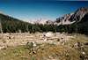
Middle St. Vrain TH-
For the northern approach of the Middle Saint Vrain Trailhead, go 4.1 miles south on Colorado 72 from the junction of Colorado 7 and Colorado 72. When you see the Middle Saint Vrain Road turn right and go 1.2 miles to the trailhead and park. For the southern approach go north 6.1 miles from the tiny town of Ward on highway 72 to Middle Saint Vrain Road on the left. Go 1.2 miles to the trailhead. You can continue on the rough road with a high clearance 4wd vehicle another 4.5 miles to the Saint Vrain Wilderness Boundary.
Red Tape
Here is a summery of the Indian Peak Wilderness Rules and Regulations.
Motorized vehicles are not permitted, including bicycles.
A permit is required for camping in the wilderness area between June 1 and Sept. 15. Permits are issued for 19 travel zones within the Indian Peak boundaries. Permits are $5.00 at the following offices. For information or to apply for a use permit, contact the U.S. Forest Service, Boulder Ranger District, 2140 Yarmouth Ave., 303-541-2500, or the Sulphur Ranger District, 9 Ten Mile Drive, P.O. Box 10, Granby, CO 80446, 1-970-887-4100. For recorded information, call the Indian Peaks Wilderness Information Line at 303-541-2519.
Only a certain number of groups are allowed in each travel zone for overnight camping. Camping is limited to two weeks in any four-week period; the two weeks can be in any travel zone.
Organized groups (maximum size of 12) must have permit for camping or hiking at all times.
Campsites must be at least 100 yards from lakes and streams.
Fires are prohibited east of the Continental Divide. Fires are allowed in certain areas west of the divide.
Dogs must be leashed.
Camping
.Here is an excellent link for Colorado Camping Reservations. An additional reservation fee of $8.65 is charged for this service. It might be worth it.
Most campgrounds in Roosevelt National Forest offer drinking water and toilet facilities. Approximately half are on a first-come, first-served basis; the rest are on a reservation system.
To reserve a campsite, call 1-800-280-2267for the hearing impaired), or register online via the National Recreation Reservation Service Internet site at http://reserveusa.com. Reservations can be made up to 240 days in advance. A camp fee of $12 per night, plus $6 for each additional car, is charged at all campgrounds with water systems. Services and fees discontinue when use declines, usually early to mid-October.
CAMP DICK is eight miles south of Allenspark on Colorado Highway 72, and one mile west of Peaceful Valley campground. This 41-site campground at 8,640 feet on Middle St. Vrain River offers some multifamily campsites, tent and trailer pads, drinking water, vault toilets, fire rings, barbecue grills, trash pickup and picnic tables. Reduced services Sept. 16-November, weather permitting. Twenty campsites can be reserved from Memorial Day weekend through mid-September.
KELLY DAHL is three miles south of Nederland on Colorado Highway 119. The 46-site campground at 8,600 feet offers tent and trailer pads, drinking water, fire rings, vault toilets, a children?s playground, picnic tables, barbecue grills and trash pickup. Reduced services Sept. 16-November, weather-permitting. Twenty-six campsites can be reserved through mid-September. The rest are first-come, first-served.
OLIVE RIDGE is one mile north of Allenspark on Colorado Highway 72. The 56-site campground near Rocky Mountain National Park and the North St. Vrain River offers tent and trailer pads, drinking water, vault toilets, picnic tables, fire rings, barbecue grills, trash pickup, a children?s playground and an amphitheater. The campground at 8,350 feet is the starting point for many trails leading into the mountains. Twenty-seven sites are available by reservation from Memorial Day weekend through mid-September. The rest are first-come, first-served. Reduced services Sept. 16-November, weather-permitting.
PEACEFUL VALLEY is eight miles south of Allenspark on Colorado Highway 72, and one mile east of Camp Dick. The 17-site campground at 8,525 feet on Middle St. Vrain River offers tent and trailer pads, some multifamily sites, drinking water, vault toilets, fire rings, barbecue rings, picnic tables and trash pickup. Eight sites can be reserved from Memorial Day weekend through mid-September. Horse rentals available at nearby stables. Reduced services Sept. 16-November, weather-permitting.
PAWNEE is six miles west of Ward in the Brainard Lake Recreation Area on Brainard Lake Drive (County Road 102) off Colorado Highway 72. The 55-site campground at 10,360 feet offers tent and trailer pads, drinking water, picnic tables, fire rings, barbecue rings, hiking, biking, fishing and nonmotorized boating. The campground closes Labor Day, but the area remains open for recreational day use year-round.
RAINBOW LAKES is 13 miles north of Nederland and five miles west of Colorado Highway 72, down a rough gravel road at the turnoff for the Colorado Mountain Research Station (Forest Road 298). The 16-site campground at 9,960 feet offers tent and trailer pads, tables, fire rings, barbecue grills and vault toilets, but no drinking water or trash pickup. Reservations are not accepted. Campground closes at the end of October. Fee is $6 per night, plus $5 per additional vehicle.
(Note: Most of the above info copy and pasted from this site.)