
|
|
Mountain/Rock |
|---|---|
|
|
49.12000°N / 19.58500°E |
|
|
6732 ft / 2052 m |
|
|
Overview
Velké Kopy / Kopy Liptowskie is the most dissimilar part of High Tatra. From geological and landscape point of view they look like Western Tatra, but at the same time they form a long lateral ridge beginning from Gładki Wierch, which evidently belongs to High Tatra. For that reason, in spite of their character is like western part of Tatra, they much often are classify as High Tatra.

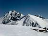
Velke Kopy from Gladka Pass
Velké Kopy ascend between Tichá Cicha Valley on the west and the north and Koprová / Koprowa Valley on the south-east and form a long (about 7 km), dismembered ridge. It begins on a large pass Závory / Zawory and forms subsequent summits (black) and passes (blue):
Tichý Vrch / Cichy Wierch, 1979m
Tiché Sedlo / Wierchcicha Przełączka, about 1900m
Zadná Garajova Kopa / Zadnia Garajowa Kopa, 1948m
Nižné Garajovo Sedlo / Garajowa Przełęcz Niżna, about 1900m
Malá Garajova Kopa / Mała Garajowa Kopa, 1929m
Prostredné Garajovo Sedlo / Garajowa Przełęcz Pośrednia, 1920m
Velká Garajova Kopa / Wielka Garajowa Kopa, 1979m – with the north ridge:
- Zadný Licierov Závrat / Zadni Rycerowy Zawracik, 1920m
- Zadná Licierova Kopa / Zadnia Rycerowa Kopa, 1957m
Vyšné Garajovo Sedlo / Garajowa Przełęcz Wyżnia, 1916m
Velká Kopa / Wielka Kopa Koprowa, 2052m – the highest summit in this group
- the north lateral ridge:
- Vyšný Licierov Závrat / Wyżni Rycerowy Zawracik, 1946m
- Velká Licierova Magura / Wyżnia Magura Rycerowa, 1997m
- Nižný Licierov Závrat / Niżny Rycerowy Zawracik, 1860m
- Licierova Kopa / Rycerowa Kopa, 1901m
- the west lateral ridge:
- Brdárov Priechod / Brdarowy Przechód, 1710m
- Brdárove Grapy (Velká, Prostredná and Malá) / Brdarowe Grapy (Wielka, Pośrednia and Mała), 1859m
Turkovo Sedlo / Turkowa Przełęcz, 1948m
Zadný Holý Vrch / Zadni Goły Wierch, 1979m
Vyšné Kôprovické Sedlo / Koprowicka Przełęcz Wyżnia, 1934m
Predný Holý Vrch / Skrajny Goły Wierch, 1970m
Nižné Kôprovické Sedlo / Koprowicka Przełęcz Niżna, 1908m
Križne / Krzyżne Liptowskie, 2039m
Because of individual summits and passes are not a destination in their own right and they are the oftenest visited as a very long, but very beautiful ridge-route, I describe them together. For hikers and skitourists it is the one of the most interesting route “between” Western and High Tatra with excellent views. For climbers there are no interesting routes.
This area since XVII century was a pastoral area of different villages on Spis. It was a favorite area of poachers from Podhale, too. They were the first conquerors of Velké Kopy. Since 1949, the day of TANAP’ creation (Tatransky Narodny Park – National Park of Tatra) it is a close nature reserve and legally it is impossible to visit it (with a Tatra guide, too), but in winter time Slovakian nature-guards do not make problems :).
 |  |  |  |  |
Getting There
FROM THE NORTH SIDE
From Polish side:
The best point to stars the journey is Zakopane – the biggest town on Polish side of Tatra Mountains. You can get there from Kraków by bus (most recommended), car or train:
By bus: there are a lot of buses from Kraków to Zakopane - time table of PKS and private lines Frey and Szwagropol.
By train: the road is much longer and dearer than by bus - time table from Kraków 0.00-11.59 a.m., 12.00-11.59 p.m. and from Zakopane.
By car: from Kraków take a road number 7 to Chyżne and follow it to Rabka. Here this road turn right to Chyżne, but you follow still straight a head in south direction by road number 95. In Poronin 5 km before Zakopane turn left (east) to border crossing point in Łysa Polana. Pass this point and go another 2 km to Polana Palenica, where you can leave your car on a big car-park. In a high season there is a problem with a place on this park (you must wait for a place sometimes a few hours) –in this case you can cross the border and leave your car on Slovakian side – the car-park is 100m after border crossing point on the right (and is much cheaper than on Polish side).
From Zakopane: Take a bus to Polana Palenica (time table of PKS, in high season there are a lot of private buses, too – a station is opposite to PKS) and go to the end to Polana Palenica (Attention! private buses sometimes has a direction-board “Morskie Oko”).
From Slovakian side:
The major city in this area is Poprad, where you can get by bus or train. From Poprad there is a lot of buses and trains to Starý Smokovec (13km) at the foot of Tatra:
train time table
bus time table
train time table from Poprad to Starý Smokovec Tatranská elektrická železnica
Maps of Starý Smokovec and Tatranská Lomnica
From Starý Smokovec take a bus to Tatranská Javorina - Lysá Pol’ana (time table) and cross the Slovakian-Polish border. From Łysa Polana you can take a bus or walk about 2 km to Polana Palenica.
In mountain:
From Polana Palenica take an asphalt road leading to Morskie Oko Chalet follow it to Wodogrzmoty Mickiewicza - a picturesque waterfall. Here turn right and follow the green-marked trail leading to Schronisko w Dolinie Pięciu Stawów Polskich.
FROM THE SOUTH SIDE
From Slovakian side
How to get to Starý Smokovec see above.
From Starý Smokovec take a bus to Podbanské.
From Polish side:
How to get to Zakopane see above.
From Zakopane take a bus to Polana Palenica (time table of PKS, in high season there are a lot of private buses, too – a station is opposite to PKS) and get off in Lysá Pol’ana / Łysa Polana. Cross the polish-slovakian border . Bus station on Slovakian side is about 100m after border crossing point on the right. Take a bus to Poprad, which goes through Starý Smokovec (time table).
From Starý Smokovec take a bus to Podbanské.
When To Climb
The best time is winter and early spring (December – May).
 |  |  |  |  |
Maps

Map of Velke Kopy' area
Tatry Wysokie, in scale 1:25 000, description in 6 languages, ISBN 83-87873-26-8, available in all shops in Zakopane. Here you can look at net version.
A high quality maps in scales 1:25 000 and 1:50 000 are produced VKU Harmanec, too. They are available at all chalets and shops in cities under Vysoke Tatry.
Red Tape
The “High Tatra” is a National Park, UN Bioheritage area and a European BioHeritage.
Velke Kopy area is additional a close nature reserve. So it is impossible to visit it legally (with a guide, too).
Only in winter time Slovakian nature-guards turn a blind eye to regulations and it is possible to visit it, but it is still illegally!
 |  |
Accommodation
There only one chalet near by Velke Kopy on Polish side and no one on Slovakian side:
Schronisko w Dolinie Pięciu Stawów Polskich – situated in Poland in the Pięciu Stawów Polskich Valley (Five Polish Lakes Velley) on a shore of Przedni Staw Polski (Polish Forelake). Chalet is opened all the year for hiking, climbing and ski mountaineering. It is the highest situated Polish chalet.
Access from:
1. Polana Palenica przed Morskim Okiem – red/green/black marked trail (2 h 30 min)
2. Schronisko przy Morskim Oku (Chalet by Morskie Oko)
- blue marked trail (by Świstówka), 2 h
- blue/yellow marked trail (by Szpiglasowa pass), 3 h 30 min
3. Chalet „Murowaniec” on Hala Gąsienicowa – a few variants of marked-trails
Contact:
adres: 34 - 500 Zakopane 1, Srytka Pocztowa 196, Poland
phone: +48 -18- 207-76-07,fax. – no.
mail: schronisko@piecstawow.pl
On Slovakian side you can overnight in Hotel Permon in Podbanske.
Absolutely no camping is permitted in the nature park. The nearest camping in Polish side is in Zakopane:
1. Camping pod Krokwią, 34-500 Zakopane Żeromskiego Str., phone/fax: + 48-18-201-22-56, email: camp@podkrokwia.pl
2. Camping KS SN PTT-1907, 34-500 Zakopane Za Strugiem 39 Str., phone/fax:+48-18-201-55-12
3. Camping Harenda, 34-500 Zakopane oś. Harenda 51b, phone/fax: +48-18-20-147-00
The nearest camping in Slovakian side is in Stara Lesna and Tatranska Lomnica.
There are plenty of cheap hotels and pensions in the area of Zakopane and Štrbské Pleso.
accommodation in Štrbské Pleso
accommodation in Zakopane
Mountain Conditions
Web forecast:
situation at this moment and forecast
Information of avalanche danger:
TOPR (in English) and HZS
Rescue:
On Slovakian side acts HZS (Horska Zachranna Sluzba)
Starý Smokovec 23, 059 60 Vysoké Tatry
phon.: 052/4422820, fax: 052/4422855,
mobil: 0903624869
e-mail: vtatry@hzs.sk
www.hzs.sk
On Polish side acts TOPR (Tatrzanskie Ochotnicze Pogotowie Ratunkowe)
adress: 34-500 Zakopane, ul.Pilsudskiego 63a,
phone: (+48)(18) 2014731 fax : (+48)(18) 2015560
E-mail: topr@topr.pl
www.topr.pl
rescue phone: (+48) 601-100-300