
|
|
Mountain/Rock |
|---|---|
|
|
49.20010°N / 19.75771°E |
|
|
Liptov/Orava |
|
|
Hiking, Mountaineering, Scrambling |
|
|
Spring, Summer, Fall, Winter |
|
|
6850 ft / 2088 m |
|
|
Overview
|
Ostrý Roháč (Slovak) Rohacz Ostry (Polish) Bánya-hegy (Hungarian)
Glossary: ostry = sharp roh/róg = horn vrch/wierch = peak sedlo/przełęcz = saddle/pass dolina = valley pleso/staw = tarn
|
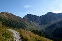
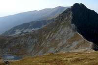
This sharp peak stands on the main ridge of the Tatra Mountains near the east end of the Roháče, which is a sub-group of the Western Tatras extending west from where the Slovakia-Poland border takes a sharp turn to the north, thus leaving the main ridge of the Tatras. Ostrý Roháč sits between Volovec/Wołowiec (2,064m) on the border and Plačlivé aka Plačlivô (2,125m) to the west of it. It has two pointed summits, a narrow crest and precipitous walls falling both to the north (to the Smutná dolina = Sad Valley) and the south-east (Jamnícka dolina). Ostrý Roháč is one of the two finest summits within the Roháče sub-group, and can only be rivalled by Baníkov.

But Polish people tend to think there are two Rohacze: Ostry and Płaczliwy (Slovak: Ostrý Roháč and Plačlivé, which translates as, respectively, Sharp&Horned and Weepy). Rohacz Ostry is nearly 40m lower than Płaczliwy (i.e. the other Rohacz the way Polish people see it), but the latter is more rounded and doesn't get so much attention. Formed of granite, or rather granitoid rock, which is the actual reason that makes the Roháče look so attractive against the gneiss-schist background, Ostrý Roháč seems to owe its name to its shape. The noun in the name of the peak appears to derive from the adjective "rohatý/rogaty (horned)", and literally means deer stag (roháč/rogacz). Whereas according to the Slovaks Ostrý Roháč is 2,087.5m high, some Polish sources maintain that its actual elevation is 2,084m. Today, technical climbing is forbidden in the area as it has been designated a nature reserve. The north face was first climbed by a team led by Walery Goetel in 1908.
 NW face NW face |
 Seen from N (centre) Seen from N (centre) |
 NE face & Jamnicky Tarn NE face & Jamnicky Tarn |
 NW in Dec 2006 (left)
 Seen from ENE (left)
 Seen from W
 Up the "horse"
 SW face SW face |
 S face S face |
 E face E face |
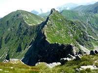
 The ridge just SW of the main summit - photo by janstolba.
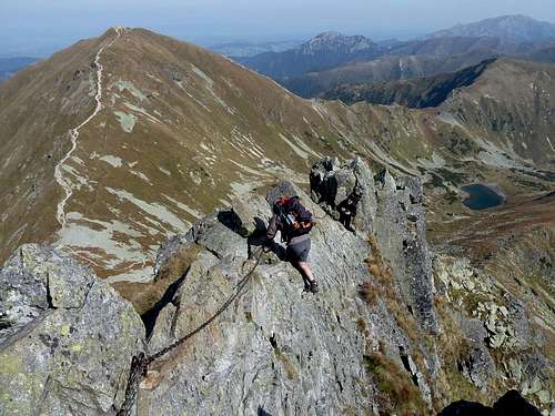 Rohacki Koń: Scrambling towards Wołowiec/Volovec (top left). Photo by visentin.
Red Tape, Border Crossing & Routes
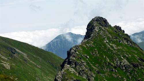
Fortunately, border crossing is no problem any more but the national park rules are quite strict. In Poland, you pay a little entry fee but you can walk all year round, although you are not allowed to leave the marked trail. In Slovakia, there is no entry fee but the higher elevation trails are closed from 1 November to 15 June. Here are the detailed regulations for various fun activities. Wołowiec (2,064m) - centre and Ostry Roháč left of the centre (2,088m)- photo by bboltr.
|


| Trailhead at | Net Elevation Gain (summit minus start) in metres | Time for Walk Up (hours) | As Crow Flies (km) | Actual Length of Hike (km) | Marks |
Via the Žiarska Valley:
|


| Trailhead at | Net Elevation Gain (summit minus start) in metres | Time for Walk Up (hours) | As Crow Flies (km) | Actual Length of Hike (km) | Marks |
If you climb both Ostrý Roháč and Plačlivé, or both Ostry Rohacz and Wołowiec, the total elevation gain increases by about 160m. If you climb all the three peaks, add 330m to the net gain (tables) to get a rough calculation of your total elevation gain. The northern routes tend to get crowded in summer. In the high season, the first of the southern routes listed in the 1st table above should offer the most solitude.
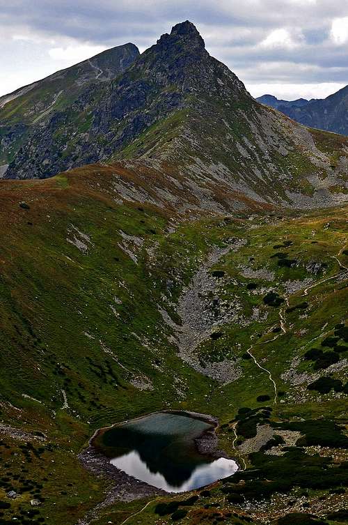
![Rohacka Dolina]() Roháčske plesa and dolina from the west - photo by mikus. Ostrý Roháč is the shadowy pyramid on the right.
Roháčske plesa and dolina from the west - photo by mikus. Ostrý Roháč is the shadowy pyramid on the right.
Maps and Books
- There are plenty of options available. For years I used Slovak maps published by VK Harmanec - for this peak, you will need sheet 112 (1:50,000). In 2018 I switched to the plastic 1:25,000 map of the Polish and Slovak Tatras by WiT. This map has a larger scale, is waterproof, durable and much cheaper.
- freemap.sk online map
- hiking.sk online map
- There is an excellent hiker's guidebook by Józef Nyka, unfortunately available only in Polish.
Accommodation
- Hut just south of the ridge: Žiarska chata
- Shelter in the Jamnícka dolina.
- There are hundreds of guesthouses and several hotels all across the south foot of the Roháče, inside the Liptov Basin. There's a campsite and a sort of hostel at the trailhead for the 1st route in the 1st table. On the outskirts of the town of Liptovský Hrádok is Borová Sihoť – my favourite campsite. If you want to rent a chalet in summertime, you have to book a few months early.
 Roháčske plesa and dolina from the west - photo by mikus. Ostrý Roháč is the shadowy pyramid on the right.
- Slovak hut just NNW of the summit: Ťatliakova chata
- Slovak hut farther north of the ridge: Zverovka
- Polish hut north of the ridge: Schronisko na Polanie Chochołowskiej
- Zuberec, Slovakia, NW of Ostrý Roháč
- Zakopane, Poland, NE of Ostry Rohacz
Getting There
Mountain Conditions & Rescue
- In Slovakia - unlike in Poland - those who do not carry commercial insurance have to pay for any rescue services rendered by Mountain Rescue Service (HZS). Mountain rescue team's phone numbers: Slovakia (HZS) 18 300, Poland (TOPR) 601 100 300
- Forecast for Žiarska Hut at 1325m
- Mountain conditions, including avalanche danger level, on HZS site
- Webcam on Lomnický štít
- AccuWeather forecast for the town of Zuberec at approx. 750m, a dozen km northwest of Ostrý Roháč:
 Ostrý Roháč (right) beyond the Jamnícka Valley, viewed from ESE - photo by rama.
kamil - Oct 28, 2010 11:12 am - Voted 10/10
diacriticsI give one more voice in favour of Slovak diacritics in the title :)
yatsek - Oct 28, 2010 8:09 pm - Hasn't voted
Re: diacriticsOK :)
Nanuls - Oct 28, 2010 3:00 pm - Voted 10/10
Ostrý Rohá?/Rohacz OstryWhy not just call it "Ostrý Rohá?/Rohacz Ostry". I use duel titles in my pages that have well known names in both Welsh and English. Or is there some reason you would not want to do that here? Cheers - D
yatsek - Oct 28, 2010 7:13 pm - Hasn't voted
Re: Ostrý Rohá?/Rohacz OstryNow that the other heading has been changed from "Ostry Rohac-Placlivy" to "Placlivy" - hopefully "Placlive/o" in the future - I think I'll just replace Ostry Rohac(z) with "Ostrý Rohá?". I don't think the Polish version is necessary since the pronunciation is nearly the same - unlike here . (Plus that "Rohacz Ostry" is the formal name, but the usual word order, i.e. adj+noun, is the same in Slovak as in Polish/English.) And we don't want to end up with "Ostrý Rohá?/Rohacz Ostry/Hegyes-Rohács (Hegyes-Szarvas/Agancsos)," do we? Any Slovaks disagree? :-) Cheers, Jacek
lcarreau - Oct 30, 2010 9:13 am - Voted 10/10
Re: Ostrý Rohá?/Rohacz OstryHey, WHY did my comments disappear? Where's my beer and/or bear??
yatsek - Oct 30, 2010 9:25 am - Hasn't voted
Re: Ostrý Rohá?/Rohacz OstryWhy don't you ask the bear? If you ask ME, I thought the woman whose comment was deleted along with yours could feel offended - she's not a native speaker of American English. I hope now everybody can have fun having their beer.
lcarreau - Oct 30, 2010 9:39 am - Voted 10/10
Re: Ostrý Rohá?/Rohacz OstrySorry, it wasn't my intention to offend anyone. If anybody should feel offended, it should be me! I always wanted to speak another language other than English. Oh, that's right! I forgot about "body language!"
yatsek - Oct 30, 2010 9:46 am - Hasn't voted
Re: Ostrý Rohá?/Rohacz OstryThanks very much for your statement, Larry. If you meant that red and white beast, barking at great American grizzlies, personally I don't mind seeing it back here.
lcarreau - Oct 30, 2010 12:23 pm - Voted 10/10
Re: Ostrý Rohá?/Rohacz OstryIt seems the bear might become angry ??? The only bears I see here are brown and black.. There's some white ones up north, but they're losing their habitat very quickly.
yatsek - Oct 31, 2010 6:00 am - Hasn't voted
Re: Ostrý Rohá?/Rohacz OstryTo all, Oh bear beer me. Our European bears have a headache too. Thanks for your comments as long as they have a bearing on a particular page. One example may be these. And the following. Rohac/Rogacz Rohac Debowy rogacz A little something for all the bears, "with some European bitterness" :-)
lcarreau - Oct 31, 2010 8:54 pm - Voted 10/10
Re: Ostrý Rohá?/Rohacz OstryPlease BEAR with me. I'm searching for a good European brew..
visentin - Oct 6, 2011 2:42 am - Voted 6/10
jeszcze cos :)Yatsek, you need to fix something on the page's title. It appears correctly in every kind of caption except on the Firefix tab's title where "?" replaces the accented letters. Have you used Peterbud's codes for the Slovak letters ? Just copy-paste the correct name while editing the page, as it is with accents and without codes. I had a similar issue on Placlivy and not it works fine.
yatsek - Oct 6, 2011 7:38 am - Hasn't voted
Re: jeszcze cos :)My daughter's made me switch to Google Chrome:) Is it OK now? On IE too?
visentin - Oct 6, 2011 7:41 am - Voted 6/10
Re: jeszcze cos :)It is :) By the way, just noticed Ostry Rohac is on the front page ! Are my pictures the reason of that ? :-o
yatsek - Oct 6, 2011 7:46 am - Hasn't voted
Re: jeszcze cos :)This can't be ruled out, can it? :) Thanks!
visentin - Oct 6, 2011 7:47 am - Voted 6/10
Re: jeszcze cos :)It can, if you post it on MBPost :D