
-
 106883 Hits
-
 95.51% Score
-
 53 Votes
|
|
Mountain/Rock |
|---|---|
|
|
41.36319°N / 111.96084°W |
|
|
Weber |
|
|
Hiking, Scrambling, Skiing |
|
|
Spring, Summer, Fall, Winter |
|
|
9712 ft / 2960 m |
|
|
Overview
Ben Lomond
Ben Lomond is the monarch of the Northern Wasatch and the most well known. It is the prominent, pyramid shaped, peak that is north of the city of Ogden. It is part of a long ridge that extends north to south between Brigham City and North Ogden Canyon. Willard Peak is located farther north along the same ridgeline and is the highest mountain in the Northern Wasatch and the highpoint of Weber County. From most vantage points Ben Lomond looks taller but Willard Peak happens to be over fifty feet higher. Ben Lomond stands out more so it receives the majority of people.
The name Ben Lomond comes from early Scottish settlers. Someone said it resembled the mountain of the same name in their country of Scotland. The Ben Lomond in Scotland is located east of Loch Lomond, and is the most southerly of the Munros. On a clear day, it is perfectly visible from the higher ground areas of Glasgow. Its name translates into "Beacon Peak". This also seems appropriate for the Ben Lomond in Utah which can be seen from many miles away.
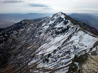
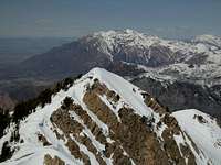
The summit is located at a small point on top of the ridge. There is a metal box that may contain a register. The views in all directions are spectacular. Looking north you will see Willard Peak with its large and rocky summit knob. Farther behind are the Wellsville Mountains and Bear River Range. To the west you can see Willard Bay and the northern end of the Great Salt Lake. Looking south and slightly east from Ben Lomond is Chilly Peak, 8459 feet, which can easily be added to a hike up Ben Lomond. To the south across North Ogden Canyon is Lewis Peak, 8031 feet. Farther to the south is Allen Peak which is next to Mount Ogden with Malans Peak below. The view looking southwest stretches from North Ogden to Davis County.
The standard route up the mountain starts from North Odgen Divide. The elevation gain is gradual and follows the ridge most of the way. Some people have said that this route is too long. I believe that most people should have no problem hiking to the top in one day. The second most used route starts from Willard Basin to the north. This is the shortest and easiest way to climb the mountain but requires a long drive on dirt roads south of Mantua. This route goes to the top of Willard Peak and then traverses the ridge over the Ben Lomond. You’ll be able to climb two peaks in one day. All other routes on the mountain are climbed less and are usually never crowded. Two trails start on the east side of Ben Lomond. One goes up to Cutler Basin and the other starts from North Fork Park.
Ben Lomond is geologically complex. The west face and ridgeline south of Ben Lomond are made predominately of quartzite from the Precambrian Period. Some of the rock is made of metamorphic slate and schists. There is also limestone and dolomite from the Cambrian and Ordovician Periods which is about 500 million years old. This area of the Wasatch has rock layers that up-lifted, tilted, and over-thrust, so older rocks may be found at higher elevations than younger ones. The ridgeline is an unusual ecosystem of pinion pine and manzanita shrub, and other low shrubs and plants. On the east side of the ridge are forests with fir, aspen, chokecherry, and maple. During spring and summer the ridges are covered in wild flowers.
Native American tribes lived in the Northern Wasatch Mountains near Ben Lomond. Ogden Valley was known to the Shoshone, Ute, and Bannock Indians as "Opecarry" which translates to stick-in-the-head. The trail through North Ogden Canyon was known as the "Lodge Pole Trail," and was their major route to the mountains. The area known as "Pole Patch" was a favorite Indian Encampment at the northernmost part of Pleasant View below Ben Lomond. They probably chose this area because of the panoramic view of the valley from the top of mountain. If you are observant you may see mountain goats at the highest elevations roaming from Willard Peak to Ben Lomond. These animals were successfully re-introduced to this habitat. There are elk, deer, and mountain lions that live in the area too. The moose population is high and they are commonly seen on the east side of Ben Lomond.
There are several steep couloirs or gullies that head straight up the south face through cliff bands. These couloirs are easy to recognize during winter. On the local news you may notice that they often refer to this mountain as Ben Lomond Peak. This is redundant since the word, Ben or Beinn, means hill, peak, or mountain in Gaelic/Scottish. This would be like saying, Peak Lomond Peak, which sounds a little odd. The USGS has it labeled as Ben Lomond on maps.
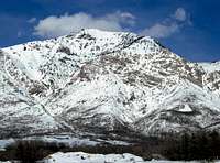
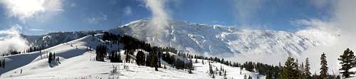
 Ben Lomond seen from North Ogden - by bigsky801
Getting There
Ben Lomond
North Ogden Divide Trailhead:
North Ogden Divide is also known as North Ogden Pass. To get there drive to Ogden and take the 12th Street exit. Then drive east towards the mountains. At 400 East on Washington, turn left and head north for 5 miles. The street will narrow and veer slightly east. It enters a residential area where you turn right at 3100 North. Drive 4 miles up the canyon where there will be a parking area on the right side of the road at the highest point of North Ogden Canyon. There is a restroom here. The trail begins across the road from the parking area.
An alternative route from I-15 is to take the 2700 North Exit (Exit #349), drive east to Washington Blvd, turn left and as you climb the street becomes 400 East. Turn east at the traffic light at 3100 North and proceed east to the trailhead. This route saves you a lot of traffic light stop-and-go from 12th Street.
North Fork Park Trailhead:
From I-15, drive to Ogden and take the 12th Street Exit. Drive through Ogden Canyon until you come to Highway 158 and the Pineview Reservoir Dam. Turn left and follow the brown recreation signs to Wolf Creek and Powder Mountain. Wind around the reservoir until you reach a fork in the road. Veer to the left here, staying on Highway 158. You will come to a stop sign. Turn left here onto Highway 162 and drive north for about 3 miles, turning left on 4100 North. Almost immediately, take the first righthand turn, onto 3300 East. There will be signs that point up this road to "North Fork" and "Avon". In 1.8 miles, turn left on the North Fork Road. One mile later turn left on 5950 North at a sign that says Ben Lomond Trailhead and North Fork Park. You'll reach another intersection with a road coming in to your left and just go straight ahead to the parking area near the horse corrals. It's a small trailhead, but isn’t used much, so you shouldn't have any problems finding a spot. Passenger cars should be able to reach this trailhead when it is dry.
Ben Lomond
Cutler Basin Trailhead:
Drive on I-15 to Ogden and take the 12th Street exit. Then drive through the canyon. At Pineview Reservoir, turn left across the dam following the brown recreation signs to Wolf Creek and Powder Mountain. Drive into the town of Eden at the stop sign near the shopping center and gas station and turn left. Turn left again at the stop sign in Liberty and drive north. Follow signs to Weber County North Fork Park, Picnic and Camp Area. Drive north instead of turning left toward North Fork Park. After passing Camp Lomondi stay straight when a dirt road turns right and uphill. Follow signs for "Cutler Flat Campground." Drive through the campground's recreation field to its north side. Turn right then immediately left just before the East Bowery Area. The trailhead is on County property at a dirt cul-de-sac near the red steel gate.
Willard Basin Trailhead:
Drive on I-15 to Brigham City and take exit 362 toward the city of Logan. Turn east on Highway 91 towards the mountains and into the canyon. Drive to Mantua and turn south into town. Go right and look for the obvious road leading up into the mountains at another right turn. It will become a washboard dirt road after that. You can drive all the way to Willard Basin if the road is dry. It is advised that you don't drive on this road after a heavy rain storm. After the first three miles, the road is too rough in spots for a passenger car. A high clearance vehicle is recommended but four wheel drive usually isn't needed. Watch out for ATV's because they travel this road a lot. Allow an hour or more to drive there from Mantua.
Here is a map for the road from Mantua to Willard Basin
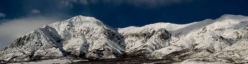
 Ben Lomond seen from the east - by highpeakskier
Routes Overview
Here are the four main routes that go to the summit of Ben Lomond. There are also more difficult routes that can be climbed. Some of these routes I did several years ago so I'll probably hike them again later and update info if needed.
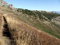
North Ogden Divide - (Skyline Trail)
This route starts from North Ogden Divide and is known as the Skyline Trail. The northern section of the trail goes to Ben Lomond and Willard Peak and the southern section goes toward Lewis Peak. It is one of the most heavily used trails in the Ogden area and the most popular route to Ben Lomond. This is also the longest route to the summit.
From the trailhead, you'll have to walk across the other side of the road to the beginning of the trail. There will be a map and a sign that states mileage. The trail goes through the forest at the bottom. It then opens up and starts climbing a series of long switchbacks up the mountainside. At 2 miles, the trail rises along a ridgeline, heading west away from the Ogden Valley. At 3 miles, the trail travels through a forest of fir, pinion, and quaking aspen as it climbs along the east side of the rising ridgeline. The cooler northern slopes of the trail include ferns among tall Douglas Fir.
At 4 miles, you've climbed 2,100 vertical feet, and the trail crosses to the west side of the ridge. The grade here is generally uphill, but with a little up and down. You'll climb another 500 feet over the next 2.7 miles. The ridgeline is the nicest part of the hike. You're high above a valley looking off toward the side. There are rocky cliffs and outcrops on the right side of the trail. Chilly Peak is one of the highpoints along the ridge that you pass by. Looking back south along the ridgeline is a great view through the stunted fir and pinion.
At 6.7 miles, you reach the base of Ben Lomond below the east side of the mountain. There is a trail junction here with routes coming up from Cutler Basin and North Fork Park. The last part is a 1.5 mile hike with 1,000 feet elevation gain over numerous switchbacks. The trail is in good condition for hikers but some mountain bikers say it is steep. You’ll recognize the summit by the large metal register which has a plaque with information on Ben Lomond.
(Distance is 8.2 miles to the summit of Ben Lomond with 3,600 feet elevation gain)
<bordercolor="993300"> <cellspacing="2"> <cellpadding="2">
 Skyline Trail Mileage Skyline Trail Mileage |
 Ben Lomond Skyline Trail Ben Lomond Skyline Trail |
 Ben Lomond Skyline Trail Ben Lomond Skyline Trail |
 Ben Lomond Skyline Trail Ben Lomond Skyline Trail |
|---|
Cutler Basin
The Cutler Basin Trail is the steepest of the three routes to Ben Lomond that originate in Ogden Valley. It is also the shortest route from the valley, with the other two starting from North Ogden Pass and North Fork Park. The Cutler Basin Trail and Ben Lomond trail from North Fork Park are not open to motor vehicles. These trails are commonly used illegally by people riding motorcycles and ATV's. The Skyline Trail is the only route open to motor vehicles.
There have been reports that this trail is overgrown in some places. There may be bushwhacking involved if you choose to hike up this route. Be prepared and carry a map and have good navigational skills. Few if any signs mark the way so it can be a little confusing for anyone who hasn't been in the area before.
The first part of the trail is well used and easy to follow. After about two miles there is a fork in the trail. Go right, just after which you'll come to Cutler Spring with a small pond. The trail is a steep climb for 3 miles and joins the Ben Lomond Trail just south of Culter Spring. The ascent to this point gains 2,300 feet of elevation on a rocky trail. This area near Cutler Basin is a very beautiful part of the Northern Wasatch. Cutler Basin trail is named after a scenic alpine basin formed by Ben Lomond and Willard Peaks. You can still see remains of fencing along the trail, where early settlers graved livestock in the summer months.
This trail then connects with the Skyline Trail which winds off to the south. The trail flattens at the base of the peak. You can now follow the switchbacks to the top of the mountain. It takes most of a day to hike the trail for most people. This trail isn't usually crowded with hikers but it is popular with horseback riders and mountain bikers. The Cutler Basin trail is used less often than the Ben Lomond trail from North Fork Park because it is steeper and more strenuous. The trail offers scenic views of Ben Lomond and Willard Peaks, and there are some outstanding rock formations along the way.
(Summer: Distance is 6 miles to the summit of Ben Lomond with 3,712 feet elevation gain)
(Winter: Distance is 4 miles to the summit from the parking area with 4,100 feet elevation gain)
<bordercolor="993300"> <cellspacing="2"> <cellpadding="2">
 Ben Lomond Northeast Face Ben Lomond Northeast Face |
 Climbing Ben Lomond Climbing Ben Lomond |
 Ben Lomond Summit Ridge Ben Lomond Summit Ridge |
 Willard Peak from Ben Lomond Willard Peak from Ben Lomond |
|---|
North Fork Park
North Fork Park is located on the east side of Ben Lomond. The trailhead begins at the south end of Weber County North Fork Park near the horse corrals. The trailhead access begins on County property, and then changes over to National Forest land. The trail is labeled on maps and signed as Ben Lomond trail.
After leaving the parking area just past the corrals, the trail crosses Cobble Creek and begins a series of switchbacks up the mountain. There is a waterfall that cascades from Cold Spring at mile 1.6. The trail is nice and wide, rocky, and in great shape. After a couple miles later, it becomes overgrown with surrounding brush making the trail hard to follow sometimes. The Ben Lomond Trail connects with the Cutler Spring Trail just before Bailey Cabin Spring. After several miles, the trail makes a turn on a ridge next to some large cliffs and heads back north.
After 3 miles the trail flattens out a bit and crosses a saddle where there are good camping spots. You'll get a nice view of Ben Lomond and Willard Peak from here. The next part of the hike takes you right below the east face of Ben Lomond. This trail then connects with the Skyline Trail which starts from North Ogden Pass. Now you can follow that trail as it switchbacks to the summit. It takes most of a day to hike this trail but it is easier than the route from Cutler Basin. Most people use this trail from summer to late fall.
(Distance is 7.6 miles to the summit of Ben Lomond with 3,962 feet elevation gain)
<bordercolor="993300"> <cellspacing="2"> <cellpadding="2">
 Ben Lomond Ben Lomond |
 Ben Lomond Ben Lomond |
 Ben Lomond Ben Lomond |
 Ben Lomond Ben Lomond |
|---|
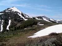
Willard Basin
This is the shortest route to Ben Lomond. This route is for people who don't mind driving a long distance on a rough dirt road to get to the trailhead. You have two options. You can start at Willard Basin Campground at about 9,000 feet and hike up the Skyline Trail that climbs south to the main ridge. Alternatively, you can drive an extra two miles to the end of the four-wheel drive road to Willard Mountain at 9,422 feet and hike the trail along the ridge to the east. The two trails meet and the trail continues southeast around Willard Peak. Look for the easiest route and leave the trail and routefind to the top. The west facing slopes are steep, but shouldn't be anymore difficult off-trail hiking.
From Willard Basin, you can easily climb Willard Peak and Ben Lomond in the same day. From the basin the trail heads south uphill through the trees, curving to the west and then to the east passing a small lake. This lake dries up into a pond during summer. The trail then goes back around to the west as it rises up to the ridge line where you can see Willard Bay and the Great Salt Lake. The trail crosses below Willard Peak and then runs across the ridge between the two peaks. It is fairly level hike until the last climb up to the summit of Ben Lomond.
(Distance is about 3 miles to the summit of Ben Lomond with 1,200 feet elevation gain)
When To Climb

Wildflowers
The best time to climb Ben Lomond is from June through October.
The route from North Ogden Pass may have snow in early summer and fall but is usually in good condition and still passable. This route is usually used to climb the mountain in winter which would be a long day. There is considerable avalanche risk on some sections of this route. Late spring is a good time to climb the mountain because the ridge will be mostly dry and the east face offers a fun glissade. During the fall season, there are fewer people out hiking and the trees are particularly colorful in this area.
The approach from Mantua and Willard Basin receives much more snow. Snowfields can be found covering the dirt road in July. The lower parts of the Cutler Basin trail and North Fork Park may be dry in early season but the upper slopes will have snow. Skiers and snowshoers frequent the area on the east side.
Climbing Ben Lomond on a very hot day may be an unpleasant experience. I suggest hiking when it's cooler because you will be out in the open on all of the routes mentioned. In summer, temperatures can be over 80 degrees so carry a lot of water and plan accordingly if hiking at that time.
Red Tape

Ben Lomond

Ben Lomond
No fees or permits are needed to climb the mountain.
Ben Lomond is located in Wasatch-Cache National Forest
If you are approaching Ben Lomond from the north, a high clearance vehicle is needed and four-wheel drive is recommended.
The route from North Ogden Pass is open to hikers, mountain bikers, motorcycles and horseback riders. Be prepared to share the trail. The majority of people hike up Ben Lomond during the summer months. Saturday is the most crowded and Sunday is more quiet. Weekdays are best time to climb if your schedule allows.
Camping

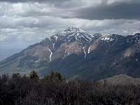
Ben Lomond
Ben Lomond from Mount Ogden
Ogden Area Campgrounds - The Ogden Ranger District has several campgrounds in the area. They offer camping opportunities in developed campgrounds, undeveloped, or dispersed campsites that are within easy reach of the Ogden area. Some sites are near Mount Ogden which is farther south and Monte Cristo which is farther east. Click on the link above or call 1-877-444-6777 to make reservations.
Box Elder Campground - This campground is located approximately five miles east of Brigham City. It sits near Box Elder Creek. The campground is adjacent to the town of Mantua, where there is a small convenience store. Restrooms and drinking water are provided. There is a day-use picnic area located at this site that is available on a first come, first serve basis.
Backcountry camping is allowed. The eastern side of the ridge offers more places to camp. The saddle where the trails meet at 8,700 feet is relatively flat, but wind-blown. Backcountry camping regulations say you must camp 1/2 mile from any road, 200 feet from any water source, and 200 feet from any trail, keep your group size to 10 people or less, and practice leave no trace techniques.
Skiing & Snowshoeing

Ben Lomond
Snowshoeing Southeast Face
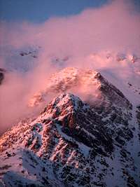
This area actually receives a lot more snow than similar elevation areas near Salt Lake City. Ben Lomond sometimes has record amounts of snow because of its location and the lake effect from the Great Salt Lake. The lake is closer to this area than mountains farther south. For people who are in good shape and experienced in winter travel, a ski or snowshoe hike to the summit of Ben Lomond would be a great adventure.
The steep and photogenic south face of Ben Lomond has been skied. Although, not very often, because it is surrounded by cliffs. I have climbed the South Couloir route and thought it was a fun climb. This is best done in spring after the snow has consolidated and conditions are stable. Urban sprawl has taken over the area below and it isn’t easy to find a good place to park now. The west face that overlooks I-15 has the most difficult and scary lines on the mountain. Few people have skied it. Couloirs on the northeast side of Chilly Peak run down toward Cobble Creek along the side of several rock slabs. The parking area at North Ogden Pass is not always plowed in winter so you may have to park on the side of the road near a large snowbank.
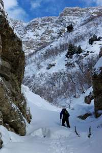
North Fork Park is one of the best places to go skiing and snowshoeing in the Ogden area. From the parking area, the roads will likely be groomed or packed by snowmobiles. For telemark skiing or snowshoeing, you can follow existing snowshoe and ski tracks uphill for about half a mile to a nice north-facing slope. You can go to the intersection of the main road that runs north and south right at the base of the mountain. To the left, the road goes over steeper and hilly terrain. To the right, there were more gently sloped roads. Two good winter routes are on the east side of the peak. Cutler Ridge starts from the Camp Utaba parking area. It enters into the bowl near Cutler Basin and is the best route during good snow conditions. The second route goes up Rodeo Ridge which ascends from North Fork Park to the basin below Ben Lomond. The northeast face features 2,000 foot gullies that provide the best routes up the mountain. The final 700 feet below the summit ridge is avalanche prone so use caution.
Thanks to seanpeckham for the following information:
If you are looking for the Camp Utaba parking spot, it turns out there are several spots that are obvious when you get to the end of the pavement/plowing on North Fork Road, and there's a Nordic Park there with groomed roads that can lead to the trail. These roads are on the topo map and it's worth consulting that so you don't go in circles. For the other route (which I haven't tried), the North Fork trail going straight west out of the corrals (which are near the trailhead label on the topo map) is easy to see with Google Earth. Also, winter mileages are lower than the summer trails, which do long traverses and lots of switchbacks. Apparently even the Wasatch Tours book reports long mileages like in summer. Actually, it was only 4 miles to the summit from the parking spot, and just under 4100' net vertical.
More information about winter routes can be found in the following books:
1) Backcountry Skiing Utah by Tyson Bradley. This book has info for skiing routes on Ben Lomond, Willard Peak and Chilly Peak.
2) Wasatch Tours, Volume 2 by Alexis Kelner and Dave Hanscom. Skiing book for the Northern Wasatch Mountains.
Paramount Pictures
Ben Lomond
Ben Lomond is thought to be the inspiration behind the Paramount Pictures logo. It is the oldest studio logo in continuous use. It's nearly a decade older than the second-oldest logo, MGM's roaring lion. It also predates Paramount Pictures as a film production entity. They trace their history back to the 1912 formation of Adolph Zukor's Famous Players Film Company, but the Paramount Pictures name was first used by a film distribution company founded by William W. Hodkinson and other independent exhibitors.
Hodkinson was the one who first designed the Paramount logo in 1914. Legend has it that he sketched an image of a star-crested, pyramid shaped, mountain on a napkin during a meeting with Adolph Zukor. It was an image he remembered of a mountain peak from his childhood in Ogden, Utah. The Paramount Pictures logo was known as "Majestic Mountain" and is one of the most familiar images in Hollywood.
There has been speculation about just where Majestic Mountain really is. Some people have assumed it to be Mount Everest or other famous mountains. If it is a real mountain at all, it is most likely Ben Lomond in the Wasatch Range. Even if Hodkinson had meant it to be a generic mountain, Ben Lomond is a prominent landmark in the Ogden area and would have been the first mountain to come to his memory. The logo has been used with only a few cosmetic changes for over half a century. The familiar mountain with its ring of 24 stars remained the most popular. Many people tend to believe that the pointed and sharp mountain used on the logo today is what Majestic Mountain actually looked like. The logo was drawn to make the mountain look more impressive than it really was.
More Information
Ben Lomond & Willard Peak
Ben Lomond - Skyline Trail - Trip report by Rocky Alps about hiking the Skyline Trail to Ben Lomond.
Ben Lomond Trip Report - Trip report on the route from North Ogden Divide and also information on the east side routes on Ben Lomond.
Ben Lomond from Willard Basin - Photos and information on the approach from Willard Basin as a shorter day hike from Jim's Utah Hiking website.
Utah Mountaineering Guidebook - By Michael R. Kelsey. This author has climbed Ben Lomond and Willard Peak in summer and winter and has info and photos.