
-
 11567 Hits
-
 93.58% Score
-
 43 Votes
|
|
Mountain/Rock |
|---|---|
|
|
40.79250°N / 111.6488°W |
|
|
Salt Lake & Summit |
|
|
Hiking, Skiing |
|
|
Spring, Summer, Fall, Winter |
|
|
7869 ft / 2398 m |
|
|
Overview
 Salt Lake Valley
Bald Mountain is located at the southern end of the Northern Wasatch Mountains. It is on a prominent ridge overlooking East Canyon, Emigration Canyon and Parleys Canyon. The mountain is approached from the Great Western Trail. This is also part of the Wasatch 100 race held in September each year. Several canyons are located below Bald Mountain. On the west side are Big and Little Hatch Canyons and on the east is Big Bear Hollow. Some of the land on the east side is owned by local ranchers.
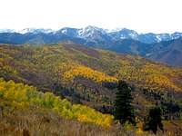
There are numerous mountains named bald and baldy in Utah and several of them are in the Wasatch Mountains. The name of this mountain comes from the fact that the summit is rounded and bare of trees especially on its west side. The view is wide open and you can see a long distance. To the south are the Central Wasatch Mountains with a good view of the Millcreek Ridge peaks. To the west is Little Dell Reservoir, Emigration Canyon, Little Mountain, and Dale Peak and Perkins Peak on Emigration Ridge. To the north is Grandview Peak, Lookout Peak, Big Mountain and surrounding points on the ridge. To the east is Lewis Peak and farther in the distance are the Uinta Mountains.
 Bald Mountain summit ridge
This mountain is the sister peak to Big Mountain which is farther to the north. They are separated by Big Mountain Pass. In 1846, the Donner Party traveled through the pass on their way to California. A year later, Orson Pratt and John Brown scouted the route and became the first Mormon pioneers to see the Salt Lake Valley. Then in July, the last group, led by Brigham Young, reached Big Mountain. They continued down canyon to the valley where they made their settlement of the area. The difficult route that the Donner Party had originally blazed through the Wasatch Mountains saved the Mormons considerable time and energy. This trail was also the route of the Overland Stage, Pony Express, California gold seekers, original telegraph line and other Mormon immigrant companies. By 1861, Parleys Canyon, which is located to the south, became the main route through the mountains.
Getting There
Big Mountain Pass Trailhead:
Drive to Interstate-80 into Parleys Canyon. Take the Mountain Dell exit. Drive and then turn north and go under the bridge. Continue on Highway 65 and you will pass a turnoff on the left toward Emigration Canyon. Keep going straight on East Canyon road. After driving several miles, the road will start ascending switchbacks to Big Mountain Pass. The trailhead will be at the top of the pass at a large dirt parking area with a restroom on the south side of the road.
Alexander Creek Trailhead:
Drive to Interstate-80 into Parleys Canyon. Take the Mountain Dell exit. Drive and then turn north and go under the bridge. Follow Highway 65 for 0.1 of a mile and on the right will be a gate. Park here and you'll see a double track starting before the hill.
Route Information
 Big Mountain Big Mountain |  Great Western Trail Great Western Trail | 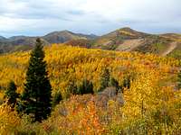 View North View North |
Big Mountain Pass Route:
From the parking area, you'll see two trails on the south side. The right one leads to the Mormon Pioneer Trail. The left one, behind the gate, is the Great Western Trail. Take the left trail which leads uphill. The trail heads through the forest as it goes along the west side of Peak 7,824. This peak isn't much lower than Bald Mountain and has over three hundred feet of prominence. It is an easy peak to add to the hike if you wish, although it is off trail and can be brushy. Near the top of the ridge, not far off the main trail, is an old Airway Beacon that has fallen over.
A little farther along the ridge, you should be able to see Bald Mountain off in the distance. Now the trail starts to lose elevation as it goes down to a basin located above Dry Hollow. You descend about four hundred feet or so. Then the trail begins to climb back up toward the mountain. The route traverses around to the west before following the north ridge to the summit. There was a small pile of rocks on top when I was there. I remember seeing a benchmark too. Because this section of trail is part of the Great Western Trail, the summit sees a fair share of hikers, runners, and bicyclists.
Big Mountain Pass route distance is 6.6 miles round trip with 1,240 feet elevation gain.
 Bald Mountain Bald Mountain |  Airway Beacon Airway Beacon |  Summit Summit |
When to Climb
The best time to hike is from mid-May through mid-November when the road is open.
Parking for the Great Western Trail starting from Alexander Creek is open year round for hiking, snowshoeing or skiing.
In winter, the road is plowed to the parking area that is overlooking Little Dell Reservoir. A little farther is a gate across the road that is closed to vehicles during this time but anyone is welcome to walk on the road.
Red Tape & Camping
 Little Dell Reservoir
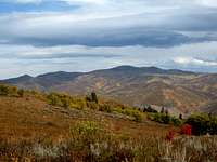 Lewis Peak
No fees or permits are needed.
Information for Little Dell Area Recreation can be found Here.
The closest campground near Bald Mountain is Affleck Park. Also be aware that this campground is only available by reservation during the summer season. Reservations may be accepted up to 48 hours in advance. Other campgrounds in the area can be found farther south in Big Cottonwood Canyon and Little Cottonwood Canyon.
Backcountry Camping is allowed in Wasatch-Cache-Uinta National Forest. Rules include: Camping 200 feet of any water source, use camp stoves to help conserve ground cover resources, and use leave no trace techniques.
Bald Mountains in Utah
This is a list of Bald Mountains in Utah which have Summitpost pages.
| 1) Bald Mountain | 11,947' | Uinta Mountains | Highest and most well known Bald Mountain in Utah |
| 2) Bald Mountain | 11,776' | Uinta Mountains | Near Bald Lake in the northern area of the Uintas |
| 3) Bald Mountain | 10,913' | Southern Wasatch | This is located north of North Peak and Mount Nebo |
| 4) Bald Mountain | 10,006' | Oquirrh Mountains | Part of Bald Mountain East and West and Sharp Mountain |
| 5) Bald Mountain | 9,346' | Central Wasatch | Near Park City by Park Benchmark and Flagstaff Mountain |
| 6) Bald Mountain | 7,869' | Northern Wasatch | South of Big Mountain Pass and north of Parleys Canyon |