
|
|
Mountain/Rock |
|---|---|
|
|
41.22277°N / 111.90088°W |
|
|
Weber |
|
|
Hiking |
|
|
7596 ft / 2315 m |
|
|
Overview


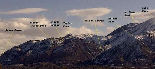
If you’re looking for an out-of-the-way, yet close enough for an afternoon hike/scramble/bushwhack, this is the peak for you. It throws about everything at you; easy going trail hiking, off-trail route finding, major thick scrub oak and mahogany to plow through, mixed in with some upper class 2 to lower class 3 scrambling, and an option for some class 4 stuff. And, the best part is, it’s only a 5 mile round trip with an easy to get to trailhead on the east bench of Ogden, Utah. What more could you ask for? Point 7,596’, sometimes called Taylor Peak, lies along the ridge known as Taylor Ridge, in the northern Wasatch Mountains of Northern Utah, just east of Ogden. It’s not the highpoint of the ridge, but it is the most prominent and easily seen from the valley below. Taylor Ridge is the headwall of Taylor Canyon, which is a popular hiking area along the east bench of Ogden. Directly west of point 7,596’, 900 feet lower, is an area known as Hidden Valley. This hanging valley sits below this point, and above the almost vertical cliffs east of 24th street. Hidden Valley can also be accessed through Taylor Canyon. I mention these areas, because they are important in determining where exactly point 7,596’ is. Route

The best way to reach the summit is to start at the 22nd street trailhead on the east bench of Ogden. This is one of many trailheads that gives access and is along the very popular Bonneville Shoreline Trail System. It’s a straight forward route, with a trail to follow for the first 1.25 miles or so. From the trailhead, head north and follow the signs for the Indian Trail. The trail gently climbs through the foothills and up into Ogden Canyon. After approximately 0.52 miles, look for a trail that cuts off to the right. This is the Hidden Valley trail. Written on a rock, about 5 ft up off the ground is “Hidden Valley”, painted in red. Not hard to miss if you’re looking for it. This is the same route as described in mountain page for Hidden Valley Dome. Hidden Valley Dome will also be bagged if you follow this route to point 7,596’. After taking the cutoff, continue south along the trail for another .75 miles. At this point you have two options. You can continue up into Hidden Valley, or jump off the trail and bushwhack up to the summit of Hidden Valley Dome. I will describe this second option, as that is the one I took. After .25 miles and a 500 ft climb, you reach the summit of Hidden Valley Dome. From the summit, you’ll be able to see exactly where you need to go. The ridge extends northeast, and then swings to the southeast to point 7,269’. From there, the objective, point 7,596’ lies .25 miles to the east. From Hidden Valley Dome there is no trail, and it is a relatively easy ridge walk through juniper and mountain mahogany to point 7,269’. Some route finding in required, but if you stay on the ridge, you’ll be fine. From point 7,269’ you will have to find the best way along the ridge, depending on how comfortable you are or your skill level. The issue is that there really aren’t too many choices. To the left (north), there are serious drop offs into Warm Water Canyon, and on the right, steep, rugged, rocky, and bushy terrain to negotiate. Because of the thick brush along the ridge top, there just isn’t a lot of room. I chose, and would suggest staying to the right, just below the ridge, picking your way along. There are no drop offs here, but plenty of loose scree in spots, some class 2 scrambling, and bushes to deal with, and it can be steep. The views south to Ogden and Allen Peaks are tremendous. The last 150 feet or so to the summit turns into some fun class 3 scrambling. Plenty of hand and foot holds, but be careful. The rock is loose and steep in spots. You wouldn’t go far if you fell, but it would bang you up pretty good. Once on top, the views into Ogden Canyon are amazing. There are two steep couloirs leading up to the summit from Warm Water Canyon and Coldwater Canyon that look like class 4-5 as well as some knife-edge ridges. From the summit, the ridge extends toward Allen Peak to the Taylor Ridge highpoint at 7,730’. This looks like a class 2-3 scramble all the way for about another .25 miles.
Getting There
From I-15 northbound or southbound, take the 21st Street exit and head east toward the mountains. Continue east until you reach Harrison Blvd. Take a left on Harrison Blvd., then right on 22nd street. Continue east until the end of the street, which dead ends at the trailhead. Very easy to get to.
Red Tape
None that I know of. There are houses near the trailhead, but all the trails along the bench and those that head up into the back country avoid private property.
Camping
There are no designated campsites, and I believe very few camp in the area. There isn't a good water source, and there are very few flat areas along the trail to camp. The closest campgrounds are up Ogden Canyon at Pineview reservoir, 20 mins away or so from the trailhead. But, if you don't mind carrying all your water, the summit of Hidden Valley Dome would be a great place to pitch a tent for a night.
When to climb
Point 7,596’ can be climbed year round. But, I would say that winter might be the best if there is a lot of snow. That way, some off those nasty bushes would be covered. Snowshoes, yak tracks, and possibly crampons would be needed. I wouldn’t even attempt it in the summer, because the bush whack would be absolutely horrible. I climbed it in December, and I thought it was thick then. I would think it would be worse in summer. Bring a machete