
|
|
Mountain/Rock |
|---|---|
|
|
41.34970°N / 111.92594°W |
|
|
Weber |
|
|
Hiking |
|
|
Spring, Summer, Fall, Winter |
|
|
8620 ft / 2627 m |
|
|
Overview
 Ben Lomond from Traverse
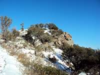 North Skyline Trail
 8246 from North Skyline Trail
Chilly Peak (8,620), next to her sexy siblings Willard and Ben Lomond, is the sister who dropped out of high school, lives in a trailer, and waitresses at IHOP. Sitting mid-way on the North Skyline Trail, about 4.5 miles from the North Ogden Divide Trailhead, Chilly is rarely selected as a primary destination and is seldom climbed. Hardcore hikers blow past her on the way to Ben Lomond while the distance/difficulty is out of range for casual climbers.
That being said, Chilly has some nice potential as either a nice summer hike or a brutal posthole ridden slough through hip-deep snow during the winter. The cold, clear skies on the ~2-mile traverse from 8,246 serves up life-in-HD views of Ogden, Pineview, and Ben Lomond Peak.
Chilly doesn’t require any great skill-level to climb except for endurance but she does roll in with a 2,400 foot elevation gain from the North Ogden Divide Trailhead (NODT) and features several challenging bushwhacks on the way to the summit. The first part of the hike from the NODT is a long series up switchbacks up the side of the mountain on a well maintained trail. At 2.25 miles, the trail flattens out and you have a choice to make. You can either continue following the trail to the right through the forest and along the east face of the mountain or continue straight up the steep mountainside to 8246 and follow the traverse to Chilly Peak. Either way is entertaining, but going up 8246 is probably the prettier route. Both routes are fairly obvious---you need to head generally north toward Ben Lomond. Round trip hike time (slow/average in winter) is around 5 hours.
You can also reach Chilly Peak from the East (North Fork Canyon) or from the North (Inspiration Point), but since you’d be closer to Ben Lomond, most people choose the bigger, sexier mountains to climb.
INFO FROM LISTS OF JOHN
Elevation : 8,620'
County: Weber
Quad: North Ogden
Coords: 41.3491°N, 111.9290°W
Rise: 200'
Saddle: 8,420'
Proximate Parent: Ben Lomond
Isolation: 1.92 miles
HIKE INFO:
Main Trailhead: North Ogden Divide Trailhead
Distance: ~4.5
Start Elevation: ~6200 Feet
Final Elevation 8,620 Feet
Vertical Gain: ~2,400 Feet
Hike time: ~5 hours
When to Climb
 View from Chilly Peak Summit
 Traverse from Chilly Peak
Chilly can be attempted any time of year. There aren’t any rivers/creeks to cross so you don’t have to worry about fording a cold stream during spring run-off. The trail may get muddy and slick during spring melt, but for the most part it doesn’t pose any limitations. You will see the occasional runner/mountain biker who is up for a challenge going up the switchbacks. For summer climbs, recommend going in the mornings or evenings (if you don’t mind hiking in the dark) to avoid the Utah sun.
Winter, however, is when Chilly changes from a cheap destination to a reasonably cool adventure. Ogden gets frequent smog inversions and the NODT is just above the foul air--going up the hillside gets you out of the crap and into the crisp/clear sunshine. The route is excellent for snowshoes. The snow on the upper part of the hike tends to get a thick crust that holds around 150 pounds and covers the stunted oak/sage/brush you’d normally have to bushwhack through going up to 8246.
Getting There
 Descent from 8246
North Ogden Divide Trailhead is located at 41.320268,-111.899164
From I-15, Take exit 344 (the 12th Street exit). Drive East on 12th Street for 2 miles. Turn North onto Washington and drive toward Ben Lomond for about 3.5 miles. Turn right onto 3100N and continue up N. Ogden Canyon Road. The trailhead will be on the top (about 3 miles) on your right. It’s big, you can’t miss it!
The trailhead doesn't have a water source but it does have an outhouse style bathroom facility. There is parking for about 30 vehicles and can accommodate horse/motor cycle trailers. The Info Kiosk has a poster map of the area and safety info. There is a monument with general historical info about the trail and the area.
There isn’t a readily available water resupply point on the anywhere on North Skyline Trail route, so you need to bring your own. The North Skyline is exposed to the South and West sun for most of the hike and it can get hot.
Red Tape and Camping
 View from North Skyline Trail
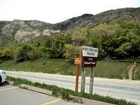 Trail Head
 Trail along East side of mountain
RED TAPE
Red tape is minimal as you are on forest service land in the Wasatch National Forest for the whole hike. Be careful with any fires and abide by USFS regulations. Dogs and horses are allowed on the trails.
ATVs and motorcycles also may be used on Skyline Trail but be sure to check out restrictions (e.g. like using the trails only when they are dry). Mountain biking is allowed.
CAMPING
There aren’t any formal camping sites in the general area, although there are plenty of spots for primitive camping. Use established fire rings whenever possible and practice “leave no trace” camping. Once again, lack of water in the area could prove to be a limiting factor.
Flora and Fauna
 Climbing 8459
Chilly peak and the surrounding area is loaded with wildlife including moose, deer, elk, mountain goats, rabbits, squirrels, and the like. Predators in area include coyotes, fox, bobcat and maybe even a mountain lion (I think I saw tracks!). Even though you may not see them, you can get good practice tracking as the animals leave signs everywhere. Like everywhere else in Utah, watch out for rattlesnakes.
The area has the usual Utah complement of Gambel Oak, Sage, Canyon Maple, White Fir and some pretty darn cool wildflowers in the spring.
Helpful Websites
www.utahmountainbiking.com/trails/skylin-n.htmwww.fs.fed.us/wcnf/unit/ogden/skyline.htm
www.weberpathways.org/trails_display.asp?ID=4
www.trimbleoutdoors.com/ViewTrip/213041