
-
 17063 Hits
-
 90.91% Score
-
 34 Votes
|
|
Mountain/Rock |
|---|---|
|
|
40.87223°N / 111.76854°W |
|
|
Davis and Morgan |
|
|
Hiking, Skiing |
|
|
Spring, Summer, Fall, Winter |
|
|
9260 ft / 2822 m |
|
|
Overview
 Sessions Mountains
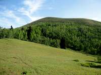
The Sessions Mountains are located east of Bountiful in the Northern Wasatch Mountains. Its official name is Sessions Mountains which makes it sound like its own mountain range. It really is just a long ridgeline consisting of several peaks. It's located among the highest mountains in the area. Grandview Peak, located farther south, is the highest. Bountiful Peak to the north is visited much more often. The Sessions Mountains Highpoint, 9,260 feet, sits on the western side of the ridge. There is another prominent point on the ridge to the east, which is 9,158 feet elevation, known as East Sessions Peak.
There are several different ways to approach the mountain. The Great Western Trail from the Skyline Sessions Trailhead travels along the northern side of the mountain. This is the shortest way to access Sessions Mountains ridge. All of the other routes will take most of a day to hike. The Big Mountain Pass route to the southeast also follows the Great Western Trail. It is a good route and also the longest in distance. Mueller Park is located below the west side of the mountain. Mountain bikers frequent the area after the snow melts in winter. From here hikers can go up to Rudys Flat on the ridge between it and North Canyon. The best route from Mueller Park is the Kenney Creek Trail which is the easiest way to climb Sessions Mountains from the west.
The city of Bountiful was settled by the Mormons on September 27, 1847, by Perrigrine Sessions and his family. This mountain would later be named after him. Sessions moved his family into their wagon and herded 300 head of cattle into the South Davis Valley. Bountiful was settled not long after the Mormon pioneers arrived in the Salt Lake Valley. The original settlement was called "Sessions Settlement," and later "North Mill Creek Canyon," and then shortened to "North Canyon." Then on February 17, 1855, the name Bountiful was accepted unanimously by the people of the community. The name was appropriate because of the city's reputation as a garden place and because "Bountiful" is the name of a city in the Book of Mormon.
Getting There
Big Mountain Pass Trailhead:
Drive to Interstate-80 into Parleys Canyon. Take the Mountain Dell exit. Drive and then turn north and go under the bridge. Continue on Highway 65 and you will pass a turnoff on the left toward Emigration Canyon. Keep going straight on East Canyon road. After driving several miles, the road will start ascending switchbacks to Big Mountain Pass. The trailhead will be at the top of the pass at a large dirt parking area with a restroom on the south side of the road.
Mueller Park Trailhead:
From I-15 in the Bountiful / North Salt Lake area, take (exit 315). Drive east to Orchard Drive. Turn right on Orchard Drive and follow it to 1800 South. Turn left on 1800 South and follow this road to the end at Mueller Park. Park before the entrance booth and walk in and you won't have to pay the fee. If this parking lot is full then you can park on the side of the street before it. The main trail up Mueller Park crosses the bridge over the creek on the right while the Kenney Creek trail is about a hundred yards past the picnic area on the left.
Skyline Sessions Trailhead:
From I-15 in Bountiful, take (exit 317) and turn right onto 400 North and go east toward the mountains for 2.6 miles. Take a sharp left toward Skyline Drive for 0.3 miles, then a slight right onto Skyline Drive. You will pass the Big B on the side of the mountain in a neighborhood. The road passes a huge dirt parking lot that usually has a lot of motorcycles, ATV riders and trucks. Then it becomes a dirt road that winds up through the mountains for several miles. It's in good condition and passenger cars shouldn't have any problems driving on the road. The trailhead is located where the road splits with Skyline Road continuing north and Sessions Mountains Road going east. The trailhead is in the large dirt parking area.
 Big Mountain Big Mountain |  Swallow Rocks Swallow Rocks |  Grandview Peak Grandview Peak |
Big Mountain Pass Route
I decided to add this route information on the main page instead of a separate route page for a few reasons. Considering that this isn't the standard route to the summit, I don't think it is done as often as the other routes mentioned. Big Mountain Pass trailhead is usually closed from mid-November through mid-May. We weren't able to get an early start as we wanted and got back late so I don't have a lot of details or photos from the descent.
Big Mountain Pass Route
This certainly isn't the shortest route to the top. It's the route I took and the one I will describe. You'll need two vehicles if you are doing the full traverse from Big Mountain Pass to Mueller Park. You could also leave a vehicle at the Skyline Sessions Trailhead and finish the traverse there making the hike a bit easier but the drive between trailheads longer. If you are going to the Sessions Mountains Highpoint and returning to Big Mountain Pass expect a long day of hiking depending on how many side trips you take. The highlight of the route is following the ridgeline which provides great views of the Northern and Central Wasatch Mountains. You will also have the opportunity to hike to other peaks along the way.
 Sessions Mountains Ridge
From Big Mountain Pass, cross the road and start hiking up the trail signed as Great Western Trail. Follow switchbacks up the mountainside and you will get to a ridge overlooking East Canyon and the Mountain Dell area. The trail continues west and then curves up to Point 8252. Now you will be heading north to Big Mountain. The main trail travels along its west side so you can just leave it and hike up the ridgeline. The summit has a rock cairn. The trail then goes west along several points on the ridge. One of these points sometimes has a large cairn on it.
There is a lot of up and down along the trail as it gets near the Swallow Rocks. There is also a North Swallow Peak if you want to add that to the hike. You'll arrive at a junction below the east ridge of Point 8349. There is usually a sign here stating that Panoramic Point is right and Swallow Rocks is left. The main trail goes along the south side of Swallow Rocks. For those of you that want to climb to the highpoint, continue up the ridge. The highest is 8,901 feet in elevation and had a metal pole on top. Follow the ridge south over Point 8730 before meeting up with the main trail again. There is a trail junction that is easy to miss. If you start hiking too far toward Lookout Peak, you probably didn't see the turnoff and need to go back.
The correct trail goes west in the direction of Grandview Peak. The trail starts descending and you lose some of the elevation that you just climbed up. It goes down to a valley overlooking City Creek Canyon. From here, the trail starts climbing again. It follows switchbacks up the south side of the ridgeline. When you get to the top you'll get your first close up view of Grandview Peak to the west. Actually, it's farther than it looks. There is a side trail that is below the east ridge of Sessions Mountains and the ridge leading to Grandview Peak. This side trail goes down to a small saddle. There is no trail to the summit but the route essentially follows the northeast ridge. If you haven't already climbed it, then you may want to add it to your hike.
Now you are onto the main Sessions Mountains ridgeline. The trail goes along the southwest side of East Sessions Peak, 9,158 feet. It is an easy walk up the ridgeline to the top of the peak. Continuing on the hike is Point 9112 and then the trail goes up another unnamed 9,000 foot peak. The trail becomes wider and you will descend steeply and lose elevation to a saddle on the other side. At this saddle is the junction with the jeep trail coming in from the Skyline Sessions trailhead to the north near Bountiful Peak. You can now see the Sessions Mountains Highpoint which is the next major peak on the ridge.
A trail goes toward the top but not all the way to the summit. You'll know you're there when you see the Great Salt Lake and the Wasatch Front to the west. The summit was large and surrounded by trees. I did not see a register at the time. After taking summit photos, go back down to where you left the trail. If you are going back to Big Mountain Pass, then reverse the route you just hiked. If going down to Mueller Park, then you'll need to find the Kenney Creek trail which generally follows the west ridge of Sessions Mountains. Near the lower slopes of the mountain you'll cross the newly built pipeline which is hard not to notice.
Route Stats:
Distance from Big Mountain Pass is 19 miles round trip.
Cumulative Elevation Gain for Sessions Mountains Highpoint is about 4,200 feet.
Great Western Trail is Class 1 and all Mountain Summits on route are Class 2
If adding Big Mountain, Swallow Rocks and Grandview Peak it will be 22+ miles with 5,500+ feet elevation gain.
Trailhead Elevation 7,420 feet and the Highest Elevations are between 9,260 and 9,410 feet
 Grandview Peak Grandview Peak |  East Sessions Peak East Sessions Peak | 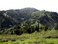 Sessions Mountains Highpoint Sessions Mountains Highpoint |
Other Routes
(1) Kenney Creek Trail
The Kenney Creek Trail follows the west ridge of Sessions Mountains. This is the standard route and the most direct way to get to the summit from the valley. The trailhead is accessible all year. It starts from Mueller Park trailhead. The trail doesn't cross the creek near the beginning. It goes up the main canyon and then onto a signed trail going left or north up onto the ridge. The trail goes over some areas of open terrain from the pipeline swath. Then it starts going east up the ridgeline. The trail goes near the top where a short off trail hike gets you to the summit. This route is 9 miles round trip with about 4,130 feet gain.
 Lookout Peak Route
(2) From Lookout Peak
Lookout Peak, 8,954 feet, is located southeast of the Sessions Mountains ridge. It is approached from two main routes, Affleck Park or Killyon Canyon, via maintained trails above Mountain Dell. There is a smaller side trail between the summit of Lookout Peak on its east ridge and Point 8292. This trail leads north on the other side of Lookout Peak. This trail goes over Point 8506 along the way before it meets the junction with the Great Western Trail which isn't signed so watch for it heading west in the direction of Grandview Peak and Sessions Mountains. This route is 16 miles round trip with 4,600 feet gain.
(3) Skyline Sessions - Great Western Trail
This is the easiest way to approach the mountain but requires driving several miles on a dirt road to get to the trailhead. The road is usually closed in winter from snow. It is in nice condition, for all vehicles, when it is open. The good news is that it starts at a high elevation. The bad news is that this isn't a particularly interesting or scenic route compared to the others. The first four miles goes south and follows a jeep road. This is the Great Western Trail and becomes a normal hiking trail as it gets closer to the peak. It reaches a small saddle below an unnamed 9,000 peak. Sessions Mountains Highpoint will be to the west. The trail goes up the ridge toward the summit from here. This route is 11 miles round trip with 1,500 feet elevation gain.
When to Climb
 Sessions Mountains
The main hiking season for this mountain is from May through October.
Expect to see snow into late spring. I found a few lingering snowfields in early June above 9,000 feet but the trail was mostly dry except in shaded areas. I hiked up a large snowfield on the summit ridge of nearby Grandview Peak during this time. After the snow melts, from late spring into summer, is the best time to see wildflowers. It can be hot in July and August with temperatures reaching above 80 degrees. The route from Big Mountain Pass is on an exposed ridgeline open to afternoon thunderstorms so make sure you have a good forecast for your hike. The Kenney Creek Trail is accessible year round and the west ridge is probably the best route in winter for snowshoeing and skiing.
There is no water available on Sessions Mountains ridge so carry it all with you.
Camping
Camping is allowed in Wasatch-Cache-Uinta National Forest. The following rules apply: Camping 200 feet of any road, trail and water source, use camp stoves to help conserve ground cover resources, and practice leave no trace techniques.
The closest campground near Big Mountain Pass is Affleck Park. Be aware that this campground is only available by reservation during the summer season. Reservations may be accepted up to 48 hours in advance. Other campgrounds in the area can be found in Big Cottonwood Canyon and Little Cottonwood Canyon. Some of these campgrounds can be reserved while others are first come first serve.
Refer to the following page for information about Campgrounds.
Red Tape
$6.00 parking fee if you drive into Mueller Park. Hikers are allowed to park before the entrance booth and walk in without paying a fee.
Sessions Mountains is located in Wasatch-Cache National Forest.
| Public Lands Information Center | Wasatch-Cache Main Headquarters |
| 3285 East 3300 South | 857 West South Jordan Parkway |
| Salt Lake City, Utah 84109 | South Jordan, Utah 84095 |
| Phone: (801) 466-6411 | Phone: (801) 999-2103 |
External Links
(1) Big Mountain Pass Route - Eric Willhite has a good description of the first half of the hike excluding Sessions Mountains.
(2) Great Western Trail North Route - Mick hiked the northern approach to Sessions Mountains from the Great Western Trail.