|
|
Mountain/Rock |
|---|---|
|
|
40.75139°N / 111.75108°W |
|
|
Salt Lake |
|
|
Hiking, Skiing |
|
|
Spring, Summer, Fall, Winter |
|
|
7376 ft / 2248 m |
|
|
Overview
Dale Peak is a smaller Wasatch summit located on the Emigration/Parleys ridge north of I-80 and Mountain Dell Reservoir. Interestingly millions of vehicles pass this summit annually on their way to and from Salt Lake. The peak offers excellent "after work" jaunts during the summer season, and great ski/snowshoeing opportunities during the winter months without much avalanche danger. The peak is easily accessed year round. Dale Peak, along with it's neighbor Perkins Peak, are the furthest southward summits of the northern Wasatch Range.The peak has excellent views of the Salt Lake Valley, Big Beacon, the Millcreek Ridge, Emigration and the Mountain Dell area below.
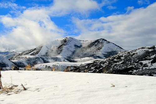 Dale Peak as seen from Parley's near Mountain Dell Reservoir.
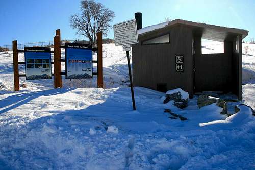
 Dean's photo showing hunters on the mountain.
 Utah Geologic Relief Map.
[img:484662:alignleft:medium:]
[img:484661:alignleft:medium:]
[img:484660:alignleft:medium:]
Getting There
Best access to this peak is from the Little Mountain Summit pass area. There are two ways to access this pass from the Salt Lake area:Emigration Canyon access:
Starting at the mouth of Emigration Canyon, drive up the canyon (east) 8.5 miles to the pass. Use caution as Emigration Canyon serves both residential, commercial, and outdoor enthusiasts alike.
Parleys Canyon access:
Once entering Parleys Canyon on I-80, continue north east for 6 miles, and take the Mountain Dell exit heading north on highway 65. Continue for 2.45 miles, and turn left, west. Continue upward to the Little Mountain Summit area for 2.1 miles.
Once reaching the pass area there is a dirt parking area with a restroom facility available. This marks the start of the route for Dale Peak. GPS info for this area is: 40.46493 N, 111.43123 W, 6,270 feet.
[img:484664:alignleft:medium:]
Red Tape
Fortunately as of now there are no fees to access this area. The Little Mountain Summit area has a high pressure gas turbine facility very near the parking area, and slightly above about 300 yards are some other gated facilities, mainly utilities.The parking area can be somewhat congested on weekends, in both winter and summer. Mountain biking is popular on the Great Western Trail to the north, and during winter the area is used for folks on inner tubes, sleds, ...etc.
If venturing out into this area during the fall hunting season be prepared to see other adventurers on the mountain wearing orange. Bringing your own orange hat and vest will lessen the risk of having a hunting accident while heading up or down the mountain. See Dean's image below.
[img:567480:alignleft:medium:Dean's photo showing hunters on the mountain.]
Camping
The best camping is probably located in the canyons further south, mainly Big and Little Cottonwood Canyons. The campsites located there are best reserved early on in the season to ensure a camp site. (Fee's are required) Back country camping in the area may be possible, however the area is dotted with private land and may not be incredibly enticing with the roar of vehicles on the Parley's Canyon side with I-80 below.Route description.
Elevation gain: 1,146 feet.Round trip mileage: 5.
Approximate time needed: 2-4 hours.
Start from the parking area, passing the gate up a maintenance road, which turns west. After about .25 of a mile, and passing most of the utility installations, follow an old jeep track which continues along the ridge crest for about two miles. You'll encounter several small hills going through this section. After approximately two miles, the jeep track disappears. Follow prominent game trails on the crest, which provides a decent alternative to bushwacking. After .25 miles you'll arrive at the base of the peak. Make you way up to the top of the sub-peak, which is about 500 vertical feet. The top of this sub-peak is covered with juniper trees. About 300 yards to the west is the summit of Dale Peak.
[img:484528:aligncenter:medium:Dale Peak Topo. ]
GPS Information.
Interestingly when I set up this page I relied on my GPS, and USGS topo software. Both these units record the summit of Dale Peak at 40.45321 N, 111.45057 W. However, when trying to get the peaks to jive up with the map provided by SP, the peaks were way off. The coordinates on the page, 40.75139 N, 111.75108 put the tag directly over the summit on the SP map. Please use your own discretion with these GPS readings if using them to venture out to the peak.Geology.
The uplift of the Emigration and Parley's canyon areas formed during the Cretaceous era, 65-144 million years ago. Cretaceous strata in the Wasatch Range is strangely absent, partially due to Sevier Thrust fault. This thrust fault caused the Emigration and Parley's synclines, which are also Cretaceous in age. Actual rock strata on the ridge line is primarily older Jurassic Twin Creek Limestone and Nugget Sandstone, the youngest rocks in the Wasatch Range other than the prominent igneous intrusive granite rocks further south. The summit of Dale is composed of Twin Creek Limestone.[img:543628:alignleft:medium:Utah Geologic Relief Map.]
History.
One thing that makes this area unique is the Donner Reed-Mormon trail which passed directly over the pass where you'll be parking your car to access this peak. Both early pioneering parties crossed this section. This was the last major obstacle for the Mormon Pioneers just before reaching "This is the Place" monument area in July of 1847. There have been plaques at the Little Mountain Pass area before, though vandals have caused issues with keeping them in place.Below is a link providing a brief explanation about the history of the pioneering trek westward from the Utah History Encyclopedia site:
Utah Mormon Trail link.
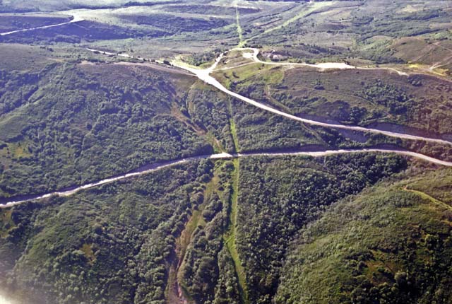
This is an aerial view of the old trail and the current road leading up Little Mountain. Little Mountain is off to the left of the photo.