Overview
![East from DeMoisy]() View to the East from DeMoisy
View to the East from DeMoisy
DeMoisy Peak (9,370) and Strawberry Peak (9,265') are the Dom DiMaggio and Jim Belushi of the mountains overlooking Ogden city Utah. Taken by themselves, they are pretty interesting but next to their much more famous sibling,
Mount Ogden , they are disrespected and ignored. Still, they are fun peaks to hike and, if you can forget the compelling Mt. Ogden, worthy destinations.
Strawberry and DeMoisy are located close to each other (about a 1/2 mile) on the south part of Mt. Ogden’s ridge immediately west of Ogden city. Mt. Ogden is to the north on the ridge (about a mile) and Snow Basin Resort is to the East. A small saddle with a Ski Tram for skiing the Strawberry Cirque separates DeMoisy/Strawberry. Of the two, DeMoisy is the harder climb with an uncertain boulder path from the south and a tree-dodging scramble from the north or west. Strawberry is a pretty much a straight walk up once you are at the Strawberry Cirque saddle. The peaks themselves are located on Snow Basin property with USFS land beginning on the west side of the ridge. The views are pretty from the top and, since they are not particularly popular, you’ll most likely have them to yourselves.
![From Strawberry Peak]() Ridgeline as seen from Strawberry
Ridgeline as seen from Strawberry
DeMoisy is an official peak with 389 feet of rise from the saddle and is the 611th highest peak in Utah. Strawberry has a 165 foot rise and is unranked. Since they are very close to each other, most hikers would go ahead and climb both while they are there. The mountain is open all year around. For summer hikers, they can be approached from a hike from Snow Basin resort or a tram ride plus ridge hike from Needles Lodge, or the long way from Beus Canyon in Ogden. In winter, they can be snowshoed from Beus Canyon or climbed in between ski runs after taking the lift.
From Lists of John
DeMoisy Peak
Elevation : 9,369'
UT Peaks Rank : 611
Counties : Morgan & Weber
Quad : Snow Basin
Coords : 41.1879°N, 111.8730°W
Rise : 389'
Saddle : 8,980'
Line Parent : Ogden, Mount
Proximate Parent : Ogden, Mount
Isolation : 0.95 miles
Strawberry Peak
Elevation : 9,265'
Counties : Morgan & Weber
Quad : Snow Basin
Coords : 41.1812°N, 111.8689°W
Rise : 165'
Saddle : 9,100'
Line Parent : De Moisy Peak
Proximate Parent : De Moisy Peak
Isolation : 0.51 miles
Getting There
![Cows on the Mt Ogden Trail]() Trail from Snow Basin
Trail from Snow Basin
The Trailhead is located at 41.218307,-111.86275. From Interstate 15, turn onto I-84E, drive 11.7 miles and take Exit 92 to Mountain Green/Huntsville. Drive .2 miles to UT-167 (North Trappers Loop Road) and follow the UT-167 for 5.5 miles. You’ll see the turn to Snow Basin (UT-226) on the top of the hill. Drive 3 miles on UT-226, Snow Basin Rd. Once you arrive at the resort, park in the main parking lot to go up Mt Ogden.
![Beus Canyon Trail]() Beus Canyon Trail
Beus Canyon Trail
Beus Canyon Trailhead:
The Trailhead is located at 41.177342,-111.929639. From I-15, take exit 341 toward 31st St; follow signs for Weber State University. After 1.2 miles merge onto UT-79 E/31st St. Turn right at US-89 S/S Washington Blvd. Turn left at 40th St. Continue onto Country Hills Dr. Turn right at S 1200 E St/Harrison Blvd. Turn left at E 4600 S. E 4600 S turns slightly right and becomes S 1900 E. Destination will be on the left.
In general, you head toward Weber State, get on Harrison Blvd, head south until you reach 4600, turn east toward the mountain, Beus Trailhead is at the top of 4600.
Route
![Mt Ogden from the Traverse]() Mt. Ogden as seen from the Traverse
Mt. Ogden as seen from the Traverse
There are three basic summer routes to get to DeMoisy and Strawberry; the long way from Beus Canyon, the service road hike from Snow Basin Resort, and the Tram hike from Needles.
Winter attempts can be made from Beus Canyon because 99% of the hike is on public land and doesn’t cross into any ski areas. Winter attempts on the Beus route will most likely require snowshoes. It is also possible, if you are skiing, to ride the Strawberry tram to the saddle and collect the summits in between skiing. Straight hiking from the Snow Basin parking lot is prohibited as it is an active ski resort all winter and much of the route goes between ski runs.
![Steep Scramble]() Scrambling up from Beus Canyon--yes, it can be steep!
Scrambling up from Beus Canyon--yes, it can be steep!
Starting from the 46th Street Beus (located 41.177342,-111.929639), the route is ~13 miles roundtrip and requires ~9 hours (slow/medium hiker). Follow
Beus Canyon trail (~5.5 miles) to ridgeline, then follow ridgeline to DeMoisy. After summiting DeMoisy, go down the rocky south side to the Ski lift and up Strawberry Peak. Vertical gain to DeMoisy Summit on the Beus trail is ~4,370 feet
Snow Basin :
Starting Snow Basin Resort (located 41.199803,-111.882091) the route is ~8 miles roundtrip and requires ~6 hours (slow/medium hiker). Follow the dirt service road (closed to private vehicles) up the side of the mountain near Needles Lodge. Around 2.25 miles, just below Needles Lodge the road splits and either continues south or up to Needles. You have a choice at this point, you can continue following the road to Strawberry Peak or take the side road to Needles Lodge, follow a trail to the ridge and proceed south to DeMoisy. Vertical gain to DeMoisy Summit is 3,019 feet.
Tram Hike from Needles:
This is the shortest route and is about 3 miles. During the summer (on weekends) pay the $15 tram ride toll at Snow Basin Resort to ride the tram to Needles Lodge. Once at Needles, follow the trail to the ridgeline and head south to DeMoisy (most everyone else goes north to Mt. Ogden) and then to Strawberry. The tram ride cuts off 2,250 feet of elevation gain and about 2.25 miles (one way). Vertical gain to DeMoisy Summit is 769 feet.
Red Tape
![Jurasic Fern Field]() Jurassic Fern Field!
Jurassic Fern Field!
There are no formal camping spots on any of the routes. Primitive camping can be done on the Beus Canyon route, although there are very few optimal spots. On the Snow Basin side, it’s a ski resort and camping is not allowed. The nearest possible camping is either the old Maples Campground near the resort or on the USFS land on the
Sardine Peak trail.
Red Tape
On the Beus Canyon trail, there is a limited Red Tape as most of the hike is in the National Forest. Please abide by federal regulations, Leave-No-Trace, and other common courtesies.
The Snow Basin people are pretty accommodating toward hikers. Mountain Bikes are allowed on the Snow Basin side but no horses, motorcycles or ATVs.
Hazards
![Mt Ogden area]() DeMoisy as seen from Beus Canyon Trail
DeMoisy as seen from Beus Canyon Trail
There are several hazards to hikers regardless of route.
Animals: The top ridge is a haven for rattlesnakes which tend to sun themselves near rock formations especially the cairns on the Beus ridge route. Help is a long way off—be extra cautious. There aren’t too many large carnivorous animals in the area, but hikers do see the occasional cougar or coyote. There aren’t any reports of anyone being attacked, but it’s worth noting they are there. Moose and deer are much more likely to be encountered…stay away especially during calving season.
On the Beus Route, you are on USFS land and there are the occasional hunters in the fall. Be sure to wear bright clothing in the fall and keep your eyes out for hunters.
Snow fields usually block some portion of all of the longer routes well into June. During the winter, the Beus route would most likely require snowshoes to get past drifts or unpacked snow. It is not a real popular winter hike, so there will also be some trailblazing involved
The bug population is usually pretty tame with limited mosquitoes, flies and wasps. The worst area for all bugs is the Bues Route especially in the fern feilds and near the small waterfall.
Water is a limiting factor in the summer depending on route chosen. On the Beus Canyon route, the last good source of water is Beus Creek ~2 miles into the hike. From the East, water is usually available at Needles Lodge (so is lunch on summer weekends).
The ridgeline is exposed and treeless. Wind and sun could be factors. Sunscreen, sunglasses and head covering are highly recommended.
Cell phone coverage is iffy all along the ridge.
The Snow Basin service road gets a lot of bike traffic which can be dangerous if the bikers are doing a rapid decent. In addition, resort service personnel ride ATVs and small vehicles up and down the road. Keep your eyes open.
Helpful Websites
http://www.utahtravelcenter.com/activities/hiking/hiking-trailsnorth/mountogden.htm
http://www.weberpathways.org/trails_display.asp?ID=19&search=yes&searchField=bikeOnly&searchText=
http://www.localhikes.com/Hikes/Mt_Ogden_7160.asp
http://www.ogden-ut.com/hiking.html
http://www.trails.com/tcatalog_trail.aspx?trailid=HGS320-004

 View to the East from DeMoisy
 Ridgeline as seen from Strawberry
 Trail from Snow Basin
 Beus Canyon Trail
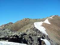 Mt. Ogden as seen from the Traverse
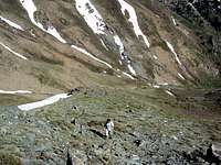 Scrambling up from Beus Canyon--yes, it can be steep!
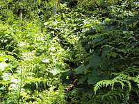 Jurassic Fern Field!
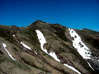 DeMoisy as seen from Beus Canyon Trail