
-
 10167 Hits
-
 88.19% Score
-
 26 Votes
|
|
Mountain/Rock |
|---|---|
|
|
45.51850°N / 7.37062°E |
|
|
Mountaineering |
|
|
11457 ft / 3492 m |
|
|
Overview
Excellent triangular pyramid situate amongst the Regions of the Valley of Aosta (Cogne/Valeille Valleys) and of the Piedmont (Valley of Locana also called Orco Valley (of the Ogre Stream Valley) and Vallone of the Piantonetto/Teleccio); it becomes visible of beautiful aspect and slender and it appears elegant and forked observing her from Northeast and as from West, cause a small triangular ante summit sited on Northwest Crest, near the true Summit. Little regular pyramid formed by three crests and as many faces; sited, like above-mentioned, on regional ridge between of the Aosta Valley/Piedmont and falling in left (East), with her profile in the shape and exactly in opposite of the renowned and famous Pisa Tower. It has two glaciers (one double) called of the Teleccio in South and of the Valeille in North (Western Valeille) and in Northeast (Eastern Valeille); both the last reunite and connect by link with the previous at quota 2.930/50 meters, nearby a sinuous transversal rocky strip. As regards the structure of the mountain we have, starting clockwise from the SW Crest or Normal Via, three ridges with as many sides:
1) - SW Ridge this ridge, which is the Normal Route, is only covered in its highest part starting at a kind of snowy terrace that separates it from the lower part that going down towards the Carpano Bivouac into the Teleccio or Telessio Vallon and adjacent to Valsoera Vallon into the high part of Canavese.
2) - Western Face it consists of a small and triangular rocky wall overhanging the Teleccio Glacier, circularly enclosed between this mountain and the Torre del Gran San Pietro. High about 150 meters and sitedd between the SW Ridge and the NO Crest it results in practice as a "broken" wall and it is rarely ascended (even if it has already been traveled downhill) constituting mostly a variant in the highest part of the latter crest, where it turns into an accentuated, steep and aerial edge.
3) - NW Crest rises from the double inlet of Colli di Teleccio and Ondezana (3.312m) and separating the Teleccio Glacier (to the Southwest) from that of Ondezana (to the Northeast). Formed by Elevations 3.338, 3.339, 3.358 meters followed by the collar 3.306 meters, after which it rears up forming a sharp edge that is generally avoided by folding on the right cio & eacute; on the West Wall, it is easy to climb, even if never not trivial; consisting of blocks stacked in the first part and solid slabs in the terminal one can be; be reached with different variants from the North:
a) - from the base about 1.150 meters of the rocks in vertical slope below the Altitude 3.358 / 60 meters with diagonal ascent East West, with grafting just above the Colle di Ondezana / Teleccio.
b) - Or with a direct ascent on the North Face of the same altitude, just more to the East (see via August 1981).
c) - And again with a direct ascent, less difficult, to the adjacent collar 3.306 meters (see via August 1980).
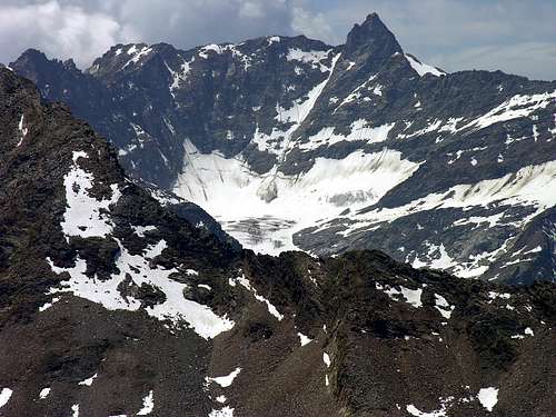
4) - N Wall this wall, formed by an almost perfect isosceles triangle, rises for almost 400 meters above the Southern extreme margin of the Valeille Glacier. Rather easy in the lower middle part (II° and II°+), it becomes rather demanding in the upper third (with passages up to IV°+ for the left route and up to III°+ with one of IV- for the parallel via on the right sector). And therefore it has two almost parallel routes, with the one on the left (East) opened in July 1940 and the one on the right 66 years later, that is, in September 2006, in lonely ascent. Next to, but outside of the triangle, there is a third route which, along a steep gully, reaches the E-SE Crest in its last part, nearby the small collar or little saddle 3.306 meters and just below the final rocky jump. in its last part, near the 3,306 meter collar or saddle and just below the final steep rocky leap, apparently more difficult than expected. Third solution was adopted by the 1940 downhill roped team complete with an "accompanying" snowslide, while uphill it was traveled with solitary climb in August 1980. All three of these routes are very exposed to falling stones, especially the first.
5) - E-SE Crest short crest which, after a small descent from Punta Scatiglion Occidentale (3.439m) or (3.407m) to the smal collar / little saddle 3.306 meters, rises "imperiously" but less difficult than it appears (from I°+ to II°-), as already illustrated in the previous itinerary, and with a safe route on fairly solid rock. Generally, even if quite rarely, it can be traveled coming from Punta di Valeille SO (3.357m) also bypassing Punta Scatiglion Orientale (3.397m) or (3.407m), therefore and perhaps in a single case (as in August 1984), along the entire integral ridge starting from the hill after the Ago delle Sengie (3.369 or 3.384 meters). In this case (from Western Scatiglion), an almost perfectly circular path is followed. It may consist of the route of first ascent of mountain, but the question is controversial (see "First Ascents").
6) - Southern Slope wide dominant slope on the Piano di Rista in the highest or Northeastern part of the Teleccio or Telessio Valley. It is divided into two distinct parts (South and South-Southeast) by two rocky buttresses that descend obliquely from the SW Ridge; in the middle of these two mighty rocky ribs a road rises in a natural "corridor" which, from the Northern end of the Muanda di Teleccio plain, goes up the long grassy-detritic dejection cone (snow until late in the season) and then enters the corridor - channel referred to above. Cut the highest rib to the right and with a gradually decreasing slope, the Summit can be reached quite easily. It is a meaningful and considerable peak, once it was enough in fashion, it is well known for its wonderful view in the Western Alpine Arc and in Gran Paradiso Mountain Chain; of easy ascent, it deserves a visit for her splendid and unusual quick glances specially over the Basin Valeille with its two underlying glaciers along the same.
Bella piramide triangolare posta tra le Regioni della Valle d'Aosta (Valli di Cogne/Vallone di Valeille) e del Piemonte (Valle di Locana, o anche detta del Torrente dell'Orco, e del Vallone del Piantonetto/Teleccio); si mostra di bel aspetto e slanciata ed appare elegante e bifida osservandola da Nordest come da Ovest, a causa una piccola e dall'aspetto triangolare anticima posta sulla Cresta NW presso la vera Vetta. Formata da tre creste e da altrettante pareti è sita, come già detto, sulla cresta confinante con l'area canavesana della Regione limitrofa del Piemonte ed è caratterizzata dalla sua linea di torre cascante verso sinistra (E), proprio al contrario della famosa Torre di Pisa. Possiede due ghiacciai (dei quali uno doppio) detti di Teleccio a Meridione e di Valeille a N (ovvero di Valeille Occidentale) ed a NE (Orientale di Valeille), questi due ultimi "saldati" tra di loro a quota 2.930/50 m~, presso una fascia rocciosa sinuosa e trasversale. Per quanto concerne la struttura della montagna abbiamo, partendo in senso orario dalla Cresta SO o Via Normale, tre creste con altrettanti versanti:
1) - Cresta SO: questa cresta, risultante quale Via Normale, viene percorsa solo nella sua parte più elevata partendo a una specie di terrazzo nevoso che la separa dalla parte inferiore dicendente verso il Bivacco Carpano nel Vallone di Teleccio o Telessio nonché adiacente al Vallone di Valsoera nella parte alta del Canavese.
2) - Versante Ovest é costituito da una piccola parete incombente al di sopra del Ghiacciaio di Teleccio, circolarmente racchiuso tra questa montagna e la Torre del Gran San Pietro. Alta circa 150 metri e compresa tra la Cresta SO e la Cresta NO risulta in pratica come una parete "monca", raramente (anche se é gia stata percorsa in discesa) viene salita costituendo per lo più variante nella parte più elevata di quest'ultima cresta, laddove la medesima si tramuta in un'accentuato spigolo aereo.
3) - Cresta NO sale dalla doppia insenatura dei Colli di Teleccio e di Ondezana (3.312 m) separando il Ghiacciaio di Teleccio (a Sudovest) da quello di Ondezana (a Nordest). Formata dalle Quote 3.338, 3.339, 3358 metri alle quali fa seguito il colletto 3.306 metri, dopo di che la stessa si impenna formando uno spigolo affilato che in genere viene evitato ripiegando sulla destra cioé sulla Parete Ovest, risulta di facile salita. anche se non banale; costituita da blocchi accatastati nella pima parte e da solidi lastroni in quella terminale può essere raggiunta con diverse varianti da Settentrione:
a) - dalla base circa 1.150 metri delle rocce sottostanti la Quota 3.358/60 metri circa con salita diagonale Est / Ovest, nonché innestandosi appena al di sopra del Colle di Ondezana/Teleccio.
b) - Oppure con salita diretta sulla Parete Nord della medesima Quota (vedi via dell'agosto 1981).
c) - ed ancora con salita diretta, nonché più facile, al collare 3.306 metri (vedi via dell'agosto 1980).
4) - Parete Nord questa parete, formata da un triangolo isoscele quasi perfetto, si eleva di quasi 400 metri sopra il margine Meridionale del Ghiacciaio di Valeille. Piuttosto facile nella parti inferiore media (II° e II°+), diventa invece piuttosto impegnativa nel terzo superiore (con passaggi fino al IV°+ per la via di sinistra e fino al III°+ con uno di IV°- per quelladi destra). Presenta due vie pressocché parallele, con quella di sinistra (Est) aperta nel luglio del 1940 e di destra 66 anni dopo, cioé nel settembre del 2006, in solitaria. Affianco, ma esternamente rispetto al triangolo, esiste un terza via che, percorrendo un ripido canalone, raggiunge la Cresta E-SE nell'ultima parte presso la selletta/colletto 3.306 metri. Questa terza soluzione é stata adottata dalla cordata del 1940 in discesa con tanto di slavina"accompagnatrice", mentre in salita é stata percorsa in solitaria nell'agosto del 1980. Tutte e tre sono molto esposte alla caduta di pietre, soprattutto la prima.
5) - Cresta E-SE breve cresta che, dopo una piccola discesa dalla Punta Scatiglion Occidentale (3.439m) oppure (3.407 m) al colletto/selletta 3.306 metri, si rialza "imperiosa" ma meno difficile di quanto non appaia (dal I°+ al II°-), come già illustrato nel precedente itinerario, e con percorso sicuro su roccia abbastanza solida. In genere, anche se piuttosto raramente, si percorre arrivando dalla Punta di Valeille SO (3.357 m) scavalcando anche la Punta Scatiglion Orientale (3.397 m) oppure (3.407 m), forse in un unico caso integralmente (in agosto 1984), percorrendo l'intera cresta a partire dal colle dopo l'Ago delle Sengie (3.369 oppure 3.384 metri). In questo caso si effettua un percorso quasi perfettamente circolare. Questa via, ma partendo da Meridione ovvero dal Vallone del Piantonetto e quindi dalla Valle dell'Orco in Canavese in Piemonte, potrebbe consistere nella via dei primi salitori della montagna, ma la questione é piuttosto controversa (vedi"First Ascents").
6) - Versante Sud largo versante dominante il Piano di Rista nella parte più alta o Nordorientale del Vallone di Teleccio oppure Telessio. Viene diviso in due distinte parti (Sud e Sud-sudest) da due contrafforti rocciosi che scendono obliquamente dalla Cresta SO; in mezzo a queste due possenti nervature rocciose sale in un naturale "corridoio" una via che, dal termine Settentrionale del piano della Muanda di Teleccio, risale il lungo cono di deiezione erboso-detritico (neve fino a stagione inoltrata) per poi infilarsi nel corridoio-canalone (nel caso di innevamento, valutare le condizioni del manto, perché altrimenti pericoloso) di cui in antecedenza. Tagliata verso destra la nervatura più alta e con pendenza in progressiva diminuzione, abbastanza agevolmente si raggiunge la Vetta. Notevole e significativa vetta, un tempo abbastanza di moda, è conosciuta per il suo splendido panorama sull'Arco Alpino Occidentale e sull'intero Gruppo del Gran Paradiso; di facile ascesa, merita visita per i colpi d'occhio splendidi ed inconsueti soprattutto sopra il Bacino della Valeille con i suoi due sottostanti ghiacciai, nonché lungo tutta la medesima.
First Ascents
- First on the Summit (from Valsoera Valley, SE Slope and traverse from Scatiglion): Martino Baretti and Company on 1866? Certainly F. Montaldo and Lanzo's Valley Mountain Guide Antonio Castagneri, same route, (Jul 22th, 1877).
- In winter (by W-SW Face): Piero Malvezzi, M. Teppex and Remo Chabod, (Jan 10th, 1937).
- SW Crest: D. Marinelli, S. Henry and E. Jeantet, (Jul 17th, 1878).
- S Slope (Right Route): P. Viglino and P. Costantino, (Jun 25th, 1921).
- S Slope (Left Route): F. Ravelli, G. Gatti and F. Sitia, (Jul 02th, 1913).
- W-SW Face (Right Route or Variant of Normal Route): F. Pergameni, F. Elter, P. A. di Béthune and G. Pizzetti-Tonion, (Jun 26th, 1915).
- W-SW Face (Left Route or Standard Route): Unknown.
- NW Ridge: C. Grosso and L. Jeantet, (Aug 18th, 1893).
- N Slope of Quota 3.358m and N-NW Edge: Osvaldo Cardellina, Alessandro Casalegno, Marco Cossard, Camillo Roberto Ferronato, Giuseppe Gallo and Giuseppe Lamazzi, (Aug 16th, 1981); in day from Lillaz to Antoldi-Malvezzi Bivouac, crossing in North Valeille Glacier; in descent NW Crest to Ondezana / Teleccio Passes.
- NW Ridge (Left or Western Variant avoiding Teleccio Pass): unknown; in ascent from NW shore of Valeille Glacier from altitude about 1150 meters in diagonal route to saddle between Quota 3.358m and Quota 3.339m on NW Crest. Note: variant rarely used when the ice conditions towards Colle di Teleccio are decidedly not good. It should also not be confused with the routes more in East of 1981 and 1980 (see instead description in "Approaches towards Teleccio Pass").
- N Slope of Collar 3.306m and W-NW Face: Osvaldo Cardellina and Marco Cossard, (Aug 20th, 1980); in day from Lillaz Hamlet towards Valeille Valley with Valeille Pasture, Guido Antoldi / Laura Malvezzi Bivouac, crossing in North up to the S-SW shore of Valeille Glacier; in descent W-SW Face to Teleccio Pass.
- N Wall (Right and Direct Route): Osvaldo Cardellina, lone, (Sep 22th, 2006) ascent in day from Lillaz Hamlet towards Valeille Alp, Guido Antoldi / Laura Malvezzi Bivouac, crossing to the Southern margin of Valeille's Glacier; in descent W-SW Face to Ondezana / Teleccio Passes.
- N Wall (Left and Direct Route): A. Bignamini, G. Costa, Angelo Notario and Leopoldo Saletti, (Jul 24th, 1940).
- N Wall (Route from little Saddle 3.433/15m): A. Bignamini, G. Costa, Angelo Notario and Leopoldo Saletti, (Jul 24th, 1940), in descent to SE Valeille Glacier. First repetition and in ascent: Osvaldo Cardellina, lone, (Aug 15th, 1980) ascent in day from Lillaz to Valeille Alp, Antoldi / Malvezzi Bivouac, crossing to the South margin of Valeille's Glacier; in descent W-SW Crest to Punta Scatiglion and Valeille SW Pass.
- E-SE Crest: Martino Baretti and Company on 1866? More probably F. Montaldo and Lanzo's Valley Mountain Guide Antonio Castagneri, same route from Valsoera Vallon, (Jul 22th, 1877). Surely R. L. G. Irving, G. H. L. Mallory and H. E. G. Thyndale, (Aug 11th, 1911) with crossing from SW Punta Valeille-Scatiglion.
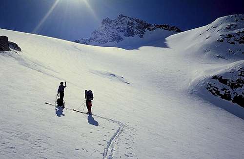
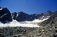
![On the Teleccio glacier near...]()
From left: E-SE Crest, three routes on N Wall, three various Variants to NW Crest or to small saddle 3.306m - First traverse from Punta Scatiglion: Martino Baretti and Company on 1866? Certainly F. Montaldo with Guide Antonio Castagneri, same route, (Jul 22th, 1877).
- First traverse from SW Valeille-Punta Scatiglion-Punta-Ondezana: R. L. G. Irving, G. H. L. Mallory and H. E. G. Thyndale, (Aug 11th, 1911).
- First great traverse from Valeille Northeast Pass to Ondezana / Teleccio Passes through Northeast, Central, Southwest Valeille-Scatiglion-Ondezana Points: Osvaldo Cardellina, Alessandro Casalegno and Maurizio Castellan, (Aug 19th, 1984), in day from bivouac, in descent NW Ridge to Ondezana / Teleccio Hills.
- First traverse Valsoera Bocchetta to Teleccio Pass, by Becco di Valsoera, Teleccio-Scatiglion-Ondezana: P. Piccio and Leopoldo Saletti, (Aug 01th, 1939).
Getting There
BY CAR:- From Torino, Milano, etc: Motorway A5. Exit at Aosta Ovest. Drive to the near Aymavilles. Follow the directions for Valle di Cogne.
- From Switzerland: through the Grand Saint Bernard Tunnel or the namesake Pass. Drive to Aosta, then follow the direction for Courmayeur on SS.26. Just after Sarre, turn to the left, in the direction of Valle di Cogne.
- From France: through Mont Blanc Tunnel or Petit St. Bernard Pass. It isn't necessary to take Motorway A5: you can drive on SS.26, in the direction of Aosta. Before arriving at the Village of Sarre, turn right following the sign for Valle di Cogne. After Aymavilles Municipality, the SR.47 crosses the Villages of Vieyes, Epinel and Cretaz and after about 25 Km arrives at Cogne (1.534m). From Cogne you can get the Village of Lillaz (1.617m).
- BY PLANE:
- Aeroporto "Corrado Gex" Saint Christophe (Aosta).
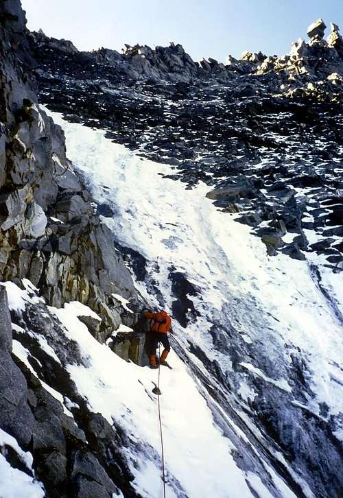
![Climbing on the normal route...]()
![On the Teleccio glacier near...]()
Approach to Hut
First day: From Cogne (1.534m) using bus or car to Lillaz (1.617m): car parking in the middle of the built up area. Start along the path n° 15 towards Valeille Walloon, after a terrace follow to a bridge near a big boulder. Cross the bridge and follow along the mule track on the left side (hydrographic) of Valeille reaching the fork 1910m. Leaving left (East) the deviation with path n° 15A towards in bottom Valeille Alp 1.902m and to Arolla Pass (2.892m), continue a big landslide must be passed along tracks. Now along the track leading to the ridge of the morain on the left side (hydrographic) of Valeille Glacier, follow the ridge till its end, once there was the old bivouac, and, on quite difficult slopes to the Laura Malvezzi/Guido Antoldi Bivouac sited on shoulder of the East Ridge North two Points of the Saint Andreas Tower (3.643m) (2.920m; the first two bivouacs destroyed by avalanches in 1970/71 and 1976/77 winters The present installed and opened, with association of the C.A.I. of the Section Aosta, on Aug 20th, 1979; 4h'15/5h'00~, from Lillaz).Primo giorno: Dall'abitato di Cogne (1.534 m) in bus o in auto raggiungere la ridente Frazione di Lillaz (1.617 m), dove si parcheggia l'auto nel grande piazzale sito quasi al centro del villaggio. Iniziare la salita imboccando il sentiero n° 15 dirigentesi nel Vallone di Valeille; dopo aver superato un gradone si prosegue sino a un ponte sito a breve distanza di un grande macigno. Dopo averlo attraversato, continuare lungo la mulattiera sulla sinistra orografica della Valeille e, dopo aver lasciato al bivio 1.910 m a sinistra (Est) la ramificazione per la sottostante Alpe di Valeille (1.902 m) che con il sentiero n° 15A sale al Colle di Arolla (2.892 m), superare su tracce di sentiero una enorme frana. Lasciare il ramo (rivolto alle pendici delle Punte Patrì) seguendo la traccia di sentiero che sale in cresta alla morena sulla sinistra orografica del Ghiacciaio di Valeille; percorrere sino al culmine la cresta, dove sorgeva il vecchio bivacco. Da questo punto, superato un tratto su terreno abbastanza malagevole, si raggiunge il Bivacco Laura Malvezzi/Guido Antoldi, sito su di una spalla della Cresta Est della Punta Nord delle due Torri di Sant'Andrea (3.643 m) (2.920 m; i primi due bivacchi distrutti dalle valanghe negli inverni 1970/71 e 1976/77. L'attuale più in alto rispetto ai due precedenti è stato inaugurato, con la compartecipazione del C.A.I. Sezione di Aosta, il 20 Agosto 1979; 4h'15/5h'00~, da Lillaz).
Approaches towards Teleccio Pass
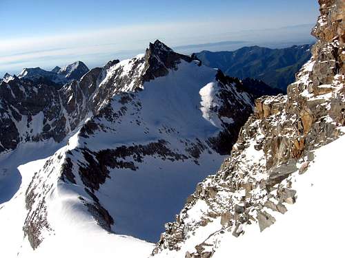
Second day: From the bivouac briefly down, by South-southeast direction to the flat Eastern Valeille Glacier, cross before toward's South (crevasses) to sinuous rocky islet base (about 2.930/40m); after, doubling in right, reach the higher part of the Western Valeille's Glacier, just and exactly below the Ondezana Point Northern Face. From this point, completely chancing direction in Southwest, go up through the entire glacier pointing the of Torre del Grande San Pietro East Wall (3.692m). Go up the easy final part directly taking aim to Teleccio Pass (3.306m), from the last stretch/slope (30°/32°) visible, always more and more covered with stony ground (see picture by Paolo Olietti, submitted on November 2008; EE/A; F+; 1h'30/1h'45).Secondo giorno: Dal bivacco scendere leggermente verso Sud-sudest sul pianeggiante Ghiacciaio Orientale di Valeille e attraversarlo dapprima verso Sud (presenza di crepacci) verso la base del sinuoso isolotto roccioso, raggiungendola sui 2.930/40 metri; quindi, doppiandolo sulla destra, raggiungere la parte superiore del Ghiacciaio Occidentale di Valeille, proprio sotto la Parete Settentrionale dell'Ondezana stessa. Da questo punto, cambiando completamente direzione in Sudovest, percorrere l'intero ghiacciaio puntando verso la Parete Est della Torre del Gran San Pietro (3.692 m); risalire la facile parte finale mirando direttamente al Colle di Teleccio (3.306 m), visibile in quest'ultimo tratto (30°/32°), sempre più ricoperto da pietrame (vedi foto di Paolo Olietti, sottomesse nel Novembre 2008; EE/A; F+; 1h'30/1h'45).
LOW DIRECT and QUICK VARIANT From Eastern Lower Valeille Glacier, right side, cross on the morainic quota (2.863m) and go up directly through South direction, towards the narrowing 2.985/2.900m~. Reaching at quota (2.961m) immediately turn right-angled in West and climb through a most steep slope, with numerous crevasses. Better and better swift route, but more and more dangerous (For a lot expert ice mountaineers; F+/PD-; 35°, even 38°, according to years; 1h'00/1h'10).
VARIANTE BASSA DIRETTA Dalla parte inferiore del Ghiacciaio Orientale di Valeille, settore destro, superare la quota morenica (2.863 m) e risalire direttamente con direzione S attraverso la "strozzatura" 2.985/2.900 m~. Giungendo verso la quota (2.961 m) voltare bruscamente ad angolo retto verso O e risalire attraverso un pendio più ripido con numerose crepacce. Sicuramente via più rapida, ma anche maggiormente pericolosa (Per alpinisti con buona esperienza di ghiacciaio; F+/PD-; 35°, anche 38° secondo le annate; 1h'00/1h'10).
 |
 |
 |
Standard Routes to Ondezana Point
Second day by W-SW Face: From pass cross level route, to East-Southeast direction, or by a brief descent into the higher also terminal part of Teleccio Glacier at centre of same slope; go up along the central couloir or by her sides through "clapeys" (great and broken boulders) and easy rotten small rocks (EE/A; steps of I°/I°+; difference in level 180/190 meters~; 0h'45/1h'00). Also from Teleccio Pass at once begin the ascent through a left/right in diagonal crossing the entire slope; rejoin towards high final part with the previous route and easily concluding to Summit (same remarks and times).Secondo giorno per la Parete W-SW: Dal colle attraversare verso Sud-sudest in falsopiano od in leggera discesa la parte alta e terminale del Ghiacciaio di Teleccio portandosi verso il centro della stessa; risalire lungo il canale centrale od appoggiandosi alle sue sponde per mezzo di grandi "clapeys" (grandi massi in patois valdostano) e facili roccette rotte (EE/A; F; tratti di I°/I°+; dislivello 180/190 metri~; 0h'45/1h'00). Oppure dal Colle di Teleccio incominciare subito la salita con un diagonale da sinistra a destra attraversante tutto il versante, per ricongiungersi verso l'alto con l'itinerario precedente e facilmente concludere in Vetta (stesse note ed orario).
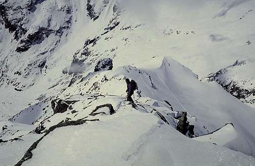
Second day by NW Ridge: from pass follow in edge, with East-southeast direction, the crest, formed by easy squared blocks, passing the two little elevations 3.338m and 3.339m; reached the Quota 3.358m, changing the direction in South-southeast, the ridge to be transformed in more steep, but non more difficult. After a little Saddle 3.306m (see under the high variant), by amusingly climbing on the edge, or hardly below on the right (West-southwest slope) of the same, reach the West Ante Summit (3.475/80m) and straight away after on the true Summit (EE/A; F+; I°/I°+, II°- in edge; difference in level in all 200/210m~; 1h'15/1h'30).
Secondo giorno per la Cresta NW: dal colle seguire sul filo e verso E-SE la cresta, formata da facili blocchi squadrati, superando in successione le due piccole quote 3.338 m e 3.339 m; raggiunta la Quota 3.358 m, cambiando direzione in S-SE, la cresta diventa più ripida ma non difficile. Dopo una piccola Sella 3.306 m (vedi la sottostante Variante Alta), arrampicando in modo divertente sul filo, oppure appoggiandosi appena a destra sul versante O della stessa, raggiungere l'Antecima O (3.475/80 m) e subito appresso la Cima (EE/A; F+; I°/I°+, sul filo II°-; dislivello complessivo 200-210 m~; 1h'15/1h'30).
HIGHER and DIRECT VARIANT: By standard route towards Teleccio Pass up to the quota 3.000m~, hardly over the union of two Valeille Glaciers, but crossing more in left (East) and with semi circular tour more and more below the walls of Valeille's SW/Scatiglion Points. Leaving these in left, move to the right under the imaginary perpendicular line of the side to the West as well as adjacent at the North-northeast Face, limited between the quota 3.358m and the little saddle 3.306m; starting from quota 3.150/60m~ of the glacier, climb the same formed by enough steep but rotten and easy rocks (sometimes snowfields in existence) getting out on Northwest Crest, between the same (A; F+/PD- for the small wall; I°/I°+, on edge of the crest II°-; difference in level altogether wall + crest 330/340 metres~; 1h'00/1h'15).
VARIANTE ALTA e DIRETTA: Con l'avvicinamento normale per il colle di Teleccio sino a quota 3.000 m~, appena sopra l’unione dei due Ghiacciai di Valeille, ma passando più a sinistra (Est) con giro a semicerchio maggiormente contro il tratto di parete compreso tra la Punta di Valeille Sudovest e la Punta Scatiglion. Portarsi sotto la perpendicolare della laterale ad Ovest nonché attigua Parete Nord-Nordest, racchiusa tra la Quota 3.358 m e la piccola sella 3.306 m; iniziando da quota 3.150/60 m~ sul ghiacciaio risalirla su rocce (a volte nevai) abbastanza ripide ma rotte e non difficili fuoriuscendo sulla Cresta Nordovest tra le due (A; F+PD- per la parete; I°/I°+, sul filo di cresta II°-; dislivello complessivo parete + cresta 330/340 m~; 1h'00/1h'15).
MAPS:
Difficulties
These routes can be considered from EE; F till EE/A; PD-.Gear
Classic for high mountain routes: rope, helmet, iceaxe, crampons.Huts
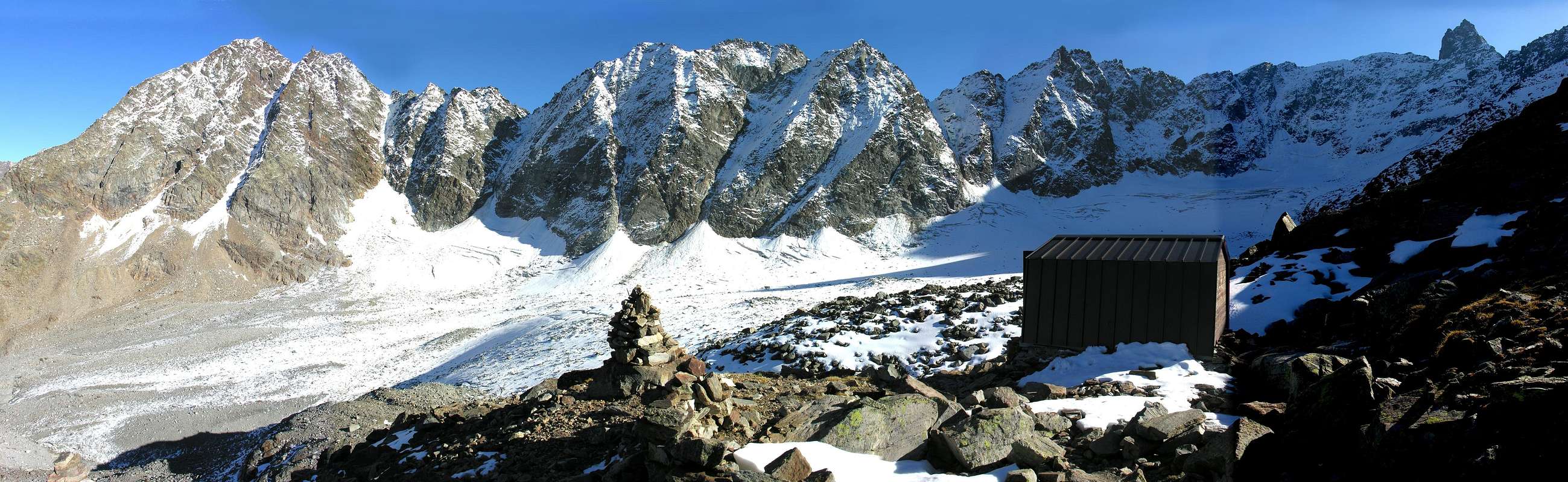
Bivacco Laura Malvezzi-Guido Antoldi (2.920 m), 9 posti.
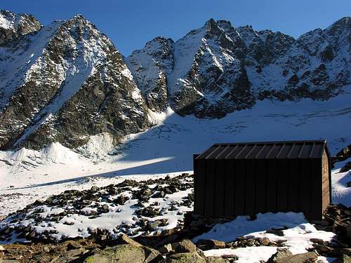
Bivacco Malvezzi-Antoldi |
Red Tape
Within the borders of the P.N.G.P. (Parco Nazionale del Gran Paradiso), at the moment (summer 2004), dogs generally are not allowed, except on a couple of trails, and camping is forbidden (except for climbers from sunset till dawn). No fees are due.Campings
Wild camping in the Parco Nazionale del Gran Paradiso is strictly forbidden!!!Mountain Condition
- You can get meteo information at the official site of the Regione Valle d'Aosta:
- Valle d'Aosta Meteo
 |
 |
 |
 |
 |
Webcam
- WEBCAM on Aosta Valley:
- Webcam
Books and Maps
BOOKS:- "Guida delle Alpi Occidentali" di Giovanni Bobba e Luigi Vaccarone C.A.I. Sezione di Torino Volume II (parte II), 25 Maggio 1896.
- "Rifugi e bivacchi in Valle d'Aosta" di Cosimo Zappelli aggiornata da Pietro Giglio. Musumeci Editore, Luglio 2002.
- "Il Parco Nazionale del Gran Paradiso (Valli di Champorcher-Clavalitè-Saint Marcel-Laures-Cogne-Valsavarenche-Conca di Pila" di Giulio Berruto 3/volume 2°, IGC, Torino 1981, 2a Ed. 2000. (in Italian)
- "Guida dei Monti d'Italia-Gran Paradiso Parco Nazionale" E. Andreis, R. Chabod, M. C. Santis, Club Alpino Italiano/Touring Club Italiano, prima Ed. 1939; seconda Ed. 1963; terza Ed. 1980.
- "Gran Paradiso", A. Gegenfurtner, G. Klotz, F. Müller, Ed. Bergverlag Rudolf Rother, Monaco 1980 (in tedesco).
- "Diari Alpinistici" di Osvaldo Cardellina e Indice Generale accompagnato da Schedario Relazioni Ascensioni 1964-2021 (inediti).
- "Gran Paradiso", G. Klotz, Ed. Bergverlag GmbH Rother, Monaco 2005 (in tedesco).
 |
 |
 |
 |
 |
- Enrico Editore Ivrea-Aosta "Gruppo del Gran Paradiso" 1:50.000.
- L'Escursionista "Valle di Cogne Carta dei Sentieri" 1:25.000.
![]()
![]()


Important Information
- REGIONE AUTONOMA VALLE D'AOSTA the official site.
- FONDAZIONE MONTAGNA SICURA Villa Cameron, località Villard de la Palud n° 1 Courmayeur (AO) Tel: 39 0165 897602 - Fax: 39 0165 897647.
- SOCIETA' GUIDE ALPINE DI COGNE Tel. 347/9473526 – 328/1373728.
- A.I.NE.VA. (Associazione Interregionale Neve e Valanghe).
- A.IA.T. Cogne Gran Paradis via Bourgeois n° 34 Tel. 0165-74040. E-mail: aiat@cogne.org
- Ezio Sport articoli sportivi - via Bourgeois n° 64 Tel. 0165-74204.
Useful Numbers
- Soccorso Alpino Cogne (SAR) Tel. 3482685406.
- Protezione Civile Valdostana località Aeroporto n° 7/A Saint Christophe (Ao) Tel. 0165-238222.
- Bollettino Meteo (weather info) Tel. 0165-44113.
- Unità Operativa di Soccorso Sanitario Tel. 118.
External Links
- P.N.G.P. official site It's the official site of the Parco Nazionale del Gran Paradiso (in five languages)
- parco.nazionale.gran.paradiso Another complete site concerning the Gran Paradiso National Park, with a lot of information (in three languages).