
|
|
Mountain/Rock |
|---|---|
|
|
40.29530°N / 105.5667°W |
|
|
Larimer |
|
|
Spring, Summer, Fall, Winter |
|
|
11006 ft / 3355 m |
|
|
Overview
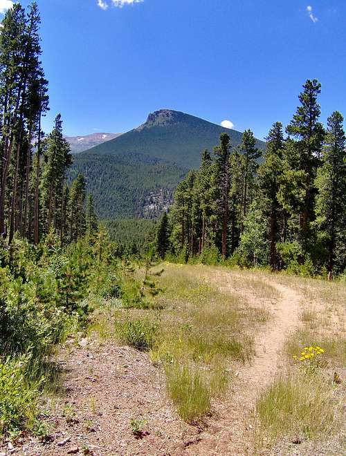
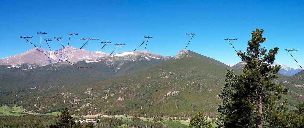
Sitting at the foot of Long's Peak roughly northeast and serving as a kind of craggy redoubt to mellow Pine Ridge is a scrambly, rocky summit named Estes Cone. The good thing about Estes Cone is that it's visible from a large portion along CO. #7. It also serves as a prominant landmark in the Tahosa Valley.
Estes Cone is comprised predominantly of the same light-gray granite that is evidenced on Long's Peak, Twin Sisters and generally, the environs south of Estes Park. Flowers are profuse in the meadows below Estes Cone come summer and Lodgepole Pine and Limber Pine blanket the surrounding forest.
This small peak is named for one of the first settlers in Estes Valley, Joel Estes. This would have been in the last quarter of the 1800's.
One of the distinguishable features about this peak is the long abandoned Eugina Mine. Originally belonging to a Mr. Carl P. Norwall and Edward Cudahy in early 1905 (RMNP wasn't established until 1915), Mr, Norwall built a cabin on site to house his wife and two daughters. They built the structures to mine for gold. Unfortunately, his diggings proved fruitless and the mine produced more dreams then gold ore. The pair of men had toiled to produce one lone tunnel almost 1,000' long. All that remains of the site now is the foundation, an old boiler, tailings and remnants of what was probably a privy. Inn Brook runs through the mine and provides good opportunities for pictures.
The trailhead for Estes Cone is shared with that of Long's Peak. So in saying that, expect the parking lot to fill up quickly on summer weekends. Make sure to arrive early. Most of the people who arrive at the Longs Peak trailhead/prking lot go on to hike/climb or take pictires of the loftier summits above treeline. This leaves Estes Cone relatively free of people. So if altitude isn't necessairly part of your outdoor plans, consider the 11,006' rocky summit of Estes Cone for a destination and bask in the solitude.
Getting There
![]() Leaving Estes Park, travel south on Co. #7 for about 9.2 miles to the Long's Peak Trailhead. Turn right (west) and drive uphill for an additional 1.1 mile to the roads terminus into the parking lot. A patrol cabin is also stationed here, typically stocked with maps, books, souvenirs and water (for a fee of course). The turn off on Co. #7 is marked.
Leaving Estes Park, travel south on Co. #7 for about 9.2 miles to the Long's Peak Trailhead. Turn right (west) and drive uphill for an additional 1.1 mile to the roads terminus into the parking lot. A patrol cabin is also stationed here, typically stocked with maps, books, souvenirs and water (for a fee of course). The turn off on Co. #7 is marked.
Since this trailhead also serves Long's Peak and most of the people/vehicles are there for Long's Peak, expect the parking lot to fill quickly during the summer months especially on the weekends.
However come winter, it's not uncommon to have the whole lot to yourself!
From Boulder, drive north on Co. #36 to the small town of Lyons. Turn left (west) onto Co. #7 and travel northwest up into the canyon for roughly 22 miles to the Long's Peak turn (on the left).
This is an easy trailhead to get to.
Red Tape
 Since Estes Cone is part of Rocky Mountain National Park, there are MANY rules/regulations that need to be followed. Pets for one are not allowed on any hiking trails in RMNP. Any pet must remain in the car/truck or back at the cabin.
Litering of course is punishable by fines, campfires unless it's in a preestablished grate is not allowed, proper food storage and backcountry camping permits must be obtained prior to setting out on the trail. And keep in mind, thanks to the messy habits of visitors for the last few years, park staff now mandates ALL backcountry campers to carry bear cannisters. And while not illegal, park staff also discourages off-trail hiking/navigation.
Recently, a bill passed in the House that now allows one to carry firearms inside national parks. However, discharging them is another matter.
A complete list of rules and regulations can be found here and they are also posted at the trailhead as well.
Be advised, park staff will not hesitate in doling out citations when they can. I've had talks with visitors about this (as a volunteer myself) and have been given tickets myself for seemingly trifle infractions. So be knowledgable. Rangers WILL ticket you.
When To Climb
This is wholly dependent of course on how comfortable one is with the seasons. Summer is understandably the busy season and when most of the crowds will be in attendance. Most of the crowds at the Long's Peak Trailhead will be aiming for Long's Peak or Mt. Meeker. There is also a good percentage of people that come to the trailhead more or less out of curiosity. With no particular destination in mind, these folks are just out for a quick hour or two hike. Sometimes going only as far as Eugina Mine.
So traffic heading to Estes Cone will be light to moderate. Summer is a great season to hike as the wildflowers are blooming, daytime temperatures are warm and people are in good spirits. Keep in mind though, Colorado's forcast come summer is fairly predictable. Afternoon thunderstorms are VERY common. Just remember to bring raingear and sunscreen.
Winter is equally a great time to visit as the throngs of people normally present are now gone. Solitude is almost a guarantee and the overall quiet of the forest is extremely relaxing. It's amazing how different the same place can be six months previous or hence!
Autumn is not to be missed for the aspens. The hillsides explode in wide swaths of yellow and orange. Mornings and evenings are colder but it still warms up sufficiently during the afternoon.
Because a trail exists pretty much the entire way to the summit with signs and cairns, Estes Cone is 'hikeable' in all seasons.
What to expect
 |
||
The trail to Estes Cone is moderately used and in terms of overall difficulty, expect a moderate to strenuous hike. A trail exists the entire distance to the summit except for the last 0.6 mile where the maintained trail then morphs into a good climbers path well marked.
Leave the trailhead (9,400ft) on a wide, well-maintained trail passing a sign-in kiosk in a northwest direction. At roughly 0.6 mile, the trail will fork near Alpine Brook (there's a picture of the sign in the Red Tape section).
This junction is marked by a sign on the left side of the trail. Take the right hand fork and proceed north on a smaller but good trail. At 1.4 miles (0.9 miles from the junction), the Eugina Mine will come into view. Inn Brook runs through the mine and area.
From the Eugina Mine, the trail turns northeast and descends gently downhill for 0.4 mile to Moore Park (campsites). The wildflowers along the meadows in Moore Park can be downright beautiful in mid to late summer. Fields of green and gold, Indian Paintbrush, Fireweed, Mountain Bluebells, Aster and Columbines can all be seen.
Leaving Moore Park, another 0.2 mile of easy hiking leads to the junction with Storm Pass Trail. This is approximately 2.0 miles from the trailhead.
Head left (west) and hike on an ascending traverse on Estes Cones' lower south slopes.
The Lodgepole Pine will start to mix with Limber Pine as you gain elevation. Most of the elevation gain on this hike is achieved within the last mile!
Leaving Storm Pass, the summit is only another 0.6-.7 mile east on a spur trail that switchbacks substantially and is marked well with ample cairns. The summit is craggy and rocky and the true summit is the easternmost point. The last few hundred feet or so is easy scrambling. This makes for a total of 3.2 miles OW.
Retrace your steps!
- Trailhead: 9,400'
- Summit: 11,006'
- Net Elevation Gain: 1,606'
Camping
 There is a great camping site at the Long's Peak trailhead. In addition, if more privacy is warranted, campsites exist at Moore Park as well.
The sites at the trailhead of which there are 26, operate on a first-come, first-serve basis and are tent status only. Read: NO RV's.
During summer, the maximum limit is three nights however come winter, this is bumped up to 14 nights. There is running water on site and summer camping fee's are $20.00/night. Kind of steep considering most of the time in summer, it won't always be quiet at night during quiet hours.
Winter fee's drop to $14.00 per night but the water is also turned off. Both cash and credit card are accepted at the Ranger Cabin I believe.
The sites located at Moore Park are attainable via the Backcountry Office (970.586.1242) or by calling reservations (800.365.2267). The elevation at Moore Park is roughly 9,733ft and there are only two sites. But there is a privy nearby! Water can be attained from nearby Inn Brook.
Expect roughly 60-90 minutes to reach the Moore Park sites.
Eugenia Mine
 An industry that Longs Peak has never really seen come into its’ own is mining. The only successful mining to really ever be done on Longs is the now long forgotten Eugina Mine. The lode that was discovered now referred to as the Eugina Mine, was found on September 23rd, 1905, the same year Estes Valley became an incorporated town. It was originally called Camp Norwall, after Carl P. Norwall, a 42-year old native of Denmark. He was hired as the muscle by Edward A. Cudahy (of Omaha, Nebraska) to do the digging...Edward himself being mostly in absentee but supplying the financial backing to lay claim and provide the means for tools. Once the lode had been established, the claim took on the name of Norwall-Cudahy Mine or occasionally, as the Amethyst Mine. The vein that was discovered was found to be about 14% copper and yielded about $6--$18 in gold. The main shaft had reached an impressive 1,500ft. The vein that was followed so deep in the earth however, was never fully actualized. But in terms of mining, this was pretty much par for the course. The Eugina Mine was abandoned in late 1912. On a quick side note, once at the mine, look for two side by side Evergreen trees. They will be VERY close to each other. There is a dog buried here and marked by the intentional planting of the trees. The dog is Jim. He was owned by Charles Hewes who helped with the winter rescue of the Agnes Vaille party. There marks the grave.
There were two other smaller mines in the vicinity as well but they proved so miniscule and ill-apt for ore, they are largely forgotten. They were known as the Pack Rat Mine, originally located along the old Longs Peak Trail and the Big Indian, located along the bank of Alpine Brook of what is now the Longs Peak Campground. Other mines in the area: Colombia Mine, Monte Carlo, Little Giant and the Last Hope were located a bit further to the south on Horse Creek along Deer Ridge; close to Meeker Park. Mining, as indelible as the industry is upon the land, sadly defines much of Colorado’s past.
The scars it leaves by those of bygone years with no cares for future effects are still in evidence by neglected and ghostly structures and scrimshaw carvings into the earth. Occasionally, and provided worse-case scenario, the land has been tainted and stained by poisonous chemicals: arsenic, cyanide, mercury, sulfates etc. and large swaths of land such as California Gulch east of Leadville or Gilman outside of Vail are now EPA Superfund sites. Longs Peak and the Estes Valley/Tahosa had the remarkable luck to avoid mining. At the disservice to the area’s lack of history in both characters and events as compared to areas like Leadville or Gilman, it more than makes up for unspoiled terrain and beauty for the current generations to enjoy.
Indeed, the Tahosa Valley may have had small dreams of hope shattered and dissolved by veins of ore that were never there, but at least Tahosa/Estes’ history are not molded by disappointment and the crashing of lachrymose tears that mining too often brings.
External Links
Protrails An ok site with further information.
Hiking in Colorado An older trip report but good with pictures
Lists of John -Statistical beta
Landscape imagery Great pictures!
14ers.com Another good trip report
Trekking Colorado: Great Report
Topo
