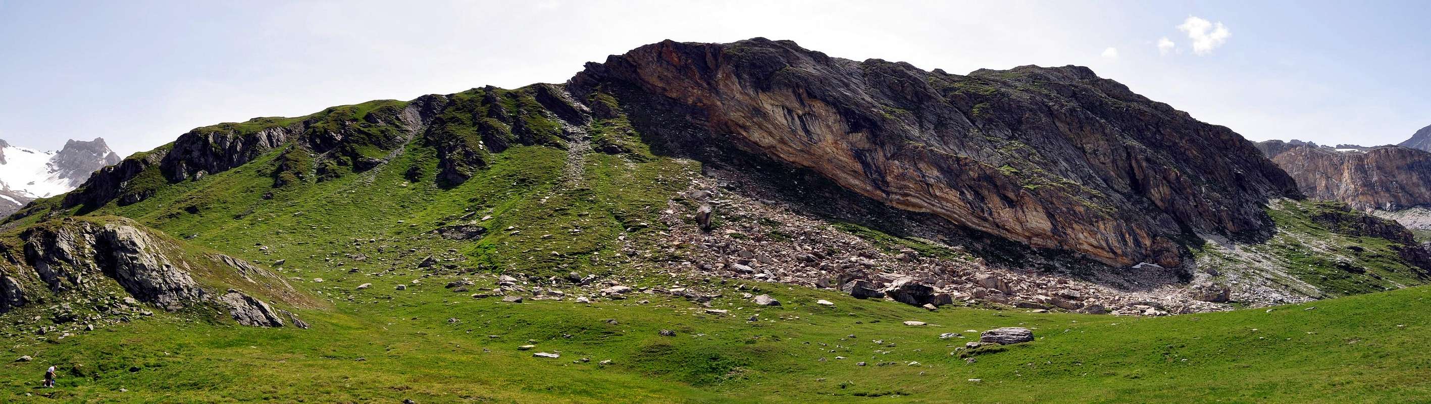
Good and brief excursion in green Rhêmes Valley below the majestic Granta Parei East Wall; growing into good training route with start, instead from Gian Federico Benevolo Refuge (2.285m), from Parking 1.848m, before of Thumel Village (1.879m). Permitting, by path n° 13C, go through Rhêmes Valley High Head towards the Doire Sources; in return visit, passing nearby Granta Parei Lake (2.570m), of the Sauches/Fond Valley. More interesting route by the coupling with short ascent to good Tsanteleinas Lake, sited on a splendid morenical amphitheatre below with same name Glacier, falling into the same. For all hikers route even for a groups with boys, present wide views on whole watershed Mountain Chain Valsavarenche/Rhêmes (Entrelor, Aouillé, Tout Blanc, Leynirs, Rosset, Gran Vaudala, Nivoletta, Basei, Bousson, Galisia Points and Basagne, Fond Rocks) and exceptional quick glance to upstairs Granta Parei (3.387m) Eastern Wall, whence the of mountain name.
Bella e breve escursione nella verde Valle di Rhêmes alle pendici della maestosa Parete Est della Granta Parei; diventando buona gita di allenamento se la partenza invece che dal Rifugio Gian Federico Benevolo (2.285 m), avviene dal Parcheggio 1.848 m antecedente il Villaggio di Thumel (1.879 m). Consente, grazie al sentiero n° 13C di percorrere l'alta testata della valle sino alle Sorgenti della Dora di Rhêmes e nel ritorno di visitare il Vallone di Sauches/Fond transitando presso il Lago della Granta Parei (2.570 m); ancora più interessante se abbinata alla non lunga risalita al bel Lago della Tsanteleina, sito in uno splendido anfiteatro morenico alle falde del Ghiacciaio di Tsanteleina, che termina la sua corsa proprio dentro lo stesso. Gita adatta a tutti ed anche a gruppi con ragazzini, prospetta viste spaziose su tutta la catena spartiacque Valsavarenche/Rhêmes (Cime dell'Entrelor e dell'Aouillé, Mont T(a)out Blanc, Punte del Leynir, del Rosset, Grand Vandala, Cime di Nivoletta, Basei, Bousson, Galisia ed in fondo alla testata Roc Basagne e Roc du Fond) e colpi d'occhio eccezionali sulla soprastante Parete Orientale Granta Parei (3.387 m), donde il nome della montagna.
First Ascents
First on the summit: Unknown.
In winter: Unknown.
Getting There
BY CAR:
From France: through the Mont Blanc Tunnel or the Col du Petit Saint Bernard: you can drive on SS.26, following directions for Aosta and, before arriving in Villeneuve, turn right towards Introd. Alternatively, you can take Motorway A5 (at Courmayeur or Morgex) and exit at Aosta Ovest.
From all the other directions: get to the Aosta Ovest exit of Motorway A5. Then drive on SS.26 Aosta, in the direction of Courmayeur; just after Villeneuve turn left towards Introd.
BY PLANE:
Aeroporto "Corrado Gex" Saint Christophe
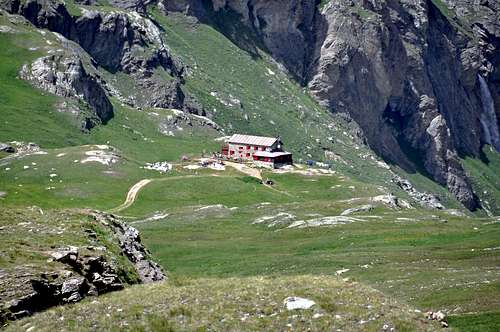
Enter the valley and, at the fork between Valsavarenche and Val di Rhêmes turn to the right (Rhêmes). Cross all the villages to arrive to Rhêmes Notre Dame and follow to Thumel (car parking), herefrom, following the dirt road on the right side (ascending) of the valley, or, better with snow, a track on the left that passing throught some fine woods leads you to the Rifugio Benevolo (2.285m).
Approach
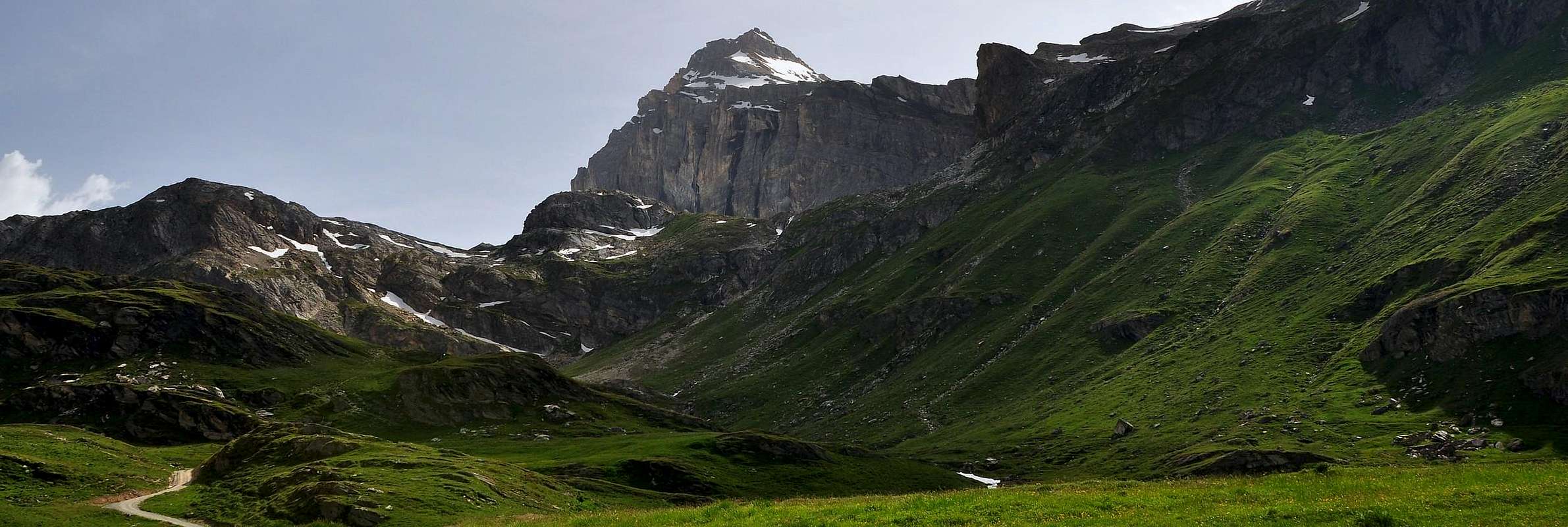
From Parking 1.848m continue in South through the road towards Pasture 1.901m and, leaving left that descending to of Thumel little Village 1.879m; worthy of visit with the tiny bridge nearby a deep gorge) and, by path n° 13, direct one steps through Great Vaudala(z) Valley (foreground with beautiful waterfall). On the contrary near the pasture start the path n° 13 to Gian Federico Benevolo Refuge (2.285m; abounding signs); crossing below the characteristic small Church 1.936m, go up by South-southwest direction along and from upper the Rhêmes Stream; leaving right the deviation to Fos Alp, cross into a small valley the, with same name, small torrent reaching, by more in Southwest route amongst prairies, the Saint-Pantaleon (2.010m) and Barmaverain (2.037m) Pastures. Very soon wade across the torrent reaching "Cascate Area" (= Waterfalls; 2.051m); by a brief and hardly more steep ascent diagonal, go upper dirt main road and through false level route join at Roman Bridge upon the torrent (2.125/30m~). From this point continue by same road with two narrow hairpin bends to Lavassey Alp (2.227m) also to rejoin by a short cut, at once over the bridge; from pasture by short cut again or by a nearby dirt road reach the refuge, sited on ample grassy-rocky promontory (E; 1h'15/1h'30).
Dal Parcheggio 1.848 m continuare verso S tramite la strada verso l'Alpeggio 1.901 m e lasciando sulla sinistra quella che brevemente scende al piccolo Villaggio di Thumel (1.879 m; merita una visita insieme al vicino ponticello sito presso una profonda gola) e con sentiero n° 13 si indirizza verso il Vallone della Grand Vaudala(z) (bella cascata frontalmente). Presso l'alpeggio si diparte invece il sentiero n° 13 per il Rifugio Gian Federico Benevolo (2.285 m; abbondanti segnalazioni), che, passando sotto la caratteristica Chiesetta 1.936 m, si indirizza verso S-SW seguendo dall'alto il corso della Dora di Rhêmes; lasciando sulla destra (W) la diramazione per l'Alpe di Fos, oltrepassare in un valloncello l'omonimo torrente raggiungendo, con percorso più a SW tra le praterie, gli Alpeggi di Saint-Pantaleon (2.010 m) e di Barmaverain (2.037 m). Subito dopo guadarne il torrente raggiungendo la località "Cascate" (2.051 m); con un breve diagonale, appena più ripido, e portarsi sulla soprastante strada sterrata poderale e, con percorso in falsopiano, pervenire al Ponte Romano sul torrente (2.125 m~). Da questo punto o continuare sulla stessa che con due stretti tornanti sale all'Alpe Lavassey (2.227 m), oppure raggiungerla tramite una breve scorciatoia subito sopra il ponte; dall'alpeggio ancora per scorciatoia, o lungo la vicina poderale, raggiungere il rifugio, sito in un ampio promontorio erboso-roccioso (E; 1h'15/1h'30).
Route to Truc Saint Hélène
From Gian Federico Benevolo Refuge briefly go down to small Fosse Bridge (2.269m) up Rhêmes Doire (= torrent); leaving right the path n° 13D, HRG (High Glacial Route) to Sauches also Soches (Sosses in ancient times) Pasture, continue by South-southeast direction, before through short part on dirt road, after by path n° 13C along the Western shore of torrent and leaving right the ground road towards Fond Alp (2.324m). I quota 2.400m~, from where even the same change, go up false level route to South-southeast crossing the Truc Saint Hélène Eastern grassy Slopes; passing a tiny brook, descending from a upper mini lake, reach a fresh source in quota 2.450m~. Continue, by same characteristics to of Doire (Stream) Rhêmes through others 450/500 meters contra the of Truc great SE Crest terminal part; doubling right the quota 2.541m and, by completely in opposite route (North-northwest) go up, always with n° 13C, through a long diagonal in progressive steep slope. Reach like this a large grassy ledge where the path, below the rocky Quota 2.678m, turn Southwest; to abandon in left and traverse right (East-northeast) along a very little path and briefly to Truc Summit (2.640m; E; 1h'30/1h'45).
Dal Rifugio Gian Federico Benevolo scendere brevemente a SW verso il ponticello di Fosse (2.269 m) sopra la Dora di Rhêmes; lasciando sulla destra il sentiero n° 13D, HRG (Alta Via Glaciale) per l'Alpe di Sauches o Soches (Sosses nei tempi andati), continuare con direzione S-SE, dapprima per breve tratto su sterrata, poi con il sentiero n° 13C, lungo la sponda Occidentale del torrente e lasciando sulla destra la strada poderale per l'Alpe di Fond (2.324 m). A quota 2.400 m~, ove anche lo stesso cambia direzione, salire in falsopiano a S-SE attraversando le pendici erbose Orientali del Truc Saint Hélène; oltrepassando un piccolo rivo, proveniente da un mini laghetto soprastante, raggiungere una fresca sorgente a quota 2.450 m~. Proseguire con le stesse caratteristiche in direzione delle Sources (= Sorgenti) de la Doire de Rhemes per altri 450/500 metri sino al termine del crestone SE del Truc; doppiarne a destra la quota 2.541 m e, con percorso completamente inverso (N-NW), risalire, sempre con n° 13C, con un lungo diagonale con pendenza in progressivo aumento. Raggiungere così una larga cengia erbosa dove il sentiero, sottostante la rocciosa Quota 2.678 m, piega a SW; abbandonarlo a sinistra e continuare a destra (E-NE) lungo un sentierucolo, che in breve porta in Vetta al Truc (2.640 m; E; 1h'30/1h'45).
Route to Tsantèleina Lake
Retracing one steps, return to grassy ledge and continue by SW direction coming up against immediately a small saddle in the shape of tiny narrow saddle (2.220m~), how far the path going down change in North-northwest direction. On the contrary continue in South-southwest by a steep but good signed track on of the moraine edge. Cross the quota 2.702m, "clapeys" (= great rotten and broken boulders) formed and, scarcely in South turning, reach the rocky bleachers 2.710m, dominant from North the lake (2.696m), extended enlarge E/W and with two typical horns, antlers one in North and one in Northeast (E; 0h'50/1h'00).
Ritornando sui propri passi ritornare alla cengia e continuare verso SW incontrando subito dopo una selletta/forcella molto stretta (2.220 m~), ove il sentiero scendendo cambia direzione in N-NW. Continuare invece a S-SW su una ripida traccia ben marcata sul filo della morena; oltrepassare la quota 2.702 m formata da "clapeys" e, voltando leggermente a S, raggiungere lo spalto roccioso 2.710 m, dominante da N il lago (2.696 m), esteso in larghezza E/W e con due caratteristiche "corna" delle quali una a NE ed una a N (E; 0h'50/1h'00).
Descent
Return by same route to little saddle/fork 2.220m and go down in North by path n° 13C; cross the of nearby Granta Parei Lake effluent in quota 2.850m~, leaving left the quota 2.876m, and reaching the crossroads 2.420m (stoneman; path n° 13D in left to Goletta Lake); from this, folding up hardly right in final part, reach Sauches also Sosses Pasture (2.313m). From alp, changing suddenly direction in South-southeast (don't let yourself get carried away, don't ancient and hemideserted in North path to Roman Bridge!), on the contrary reach, before, a little Sauches Bridge, after again, the of departure small Fosse Bridge (2.269m) and, by a brief ascent, to refuge (E; 1h'15 from Tsanteleina Lake or 0h'45 saddle/fork 2.220m~).
Rientrare con lo stesso percorso alla selletta/forcella 2.220 m~ e scendere verso N con il sentiero n° 13C; attraversare l'emissario del vicino Lago della Granta Parei a quota 2.850 m~, lasciando sulla sinistra la quota 2.876 m, e raggiungendo il bivio 2.420 m (ometto; sentiero n° 13D a sinistra per il Lago di Goletta); da questo, piegando leggermente a destra nella parte finale, raggiungere l'Alpe di Sauches o Sosses (2.313 m). Dall'alpe, cambiando bruscamente direzione in S-SE (non lasciarsi attrarre dal vecchio sentiero semi abbandonato che verso N scende al Ponte Romano!), raggiungere invece prima il grazioso ponticello di Sauches e, nuovamente, il piccolo Ponte di Fosse (2.269 m) della partenza, che con breve risalita riporta al rifugio (E; 1h'15 dal Lago della Tsanteleina oppure 0h'45 dalla selletta/forcella 2.220 m~).
The Eastern side of the valley belongs to Gran Paradiso National park, the Western one is out of the boundaries of the Park ... but nature must be respected.
Campings
Remember that free camping is forbidden (except for emergency reasons, over 2.500m, from darkness until dawn).
Mountain Conditions
You can get meteo information at the official site of the Regione Valle d'Aosta:
Parents refers to a larger category under which an object falls. For example, theAconcagua mountain page has the 'Aconcagua Group' and the 'Seven Summits' asparents and is a parent itself to many routes, photos, and Trip Reports.

 5995 Hits
 85.87% Score
 21 Votes