Glaciers of Gressoney Valley (Lyskamms - Monte Rosa)

Glaciers of Gressoney Valley (Lyskamms - Monte Rosa)

Page Type Page Type: Area/Range
Location Lat/Lon: 45.86592°N / 7.81071°E
Sign the Climber's Log

Overview

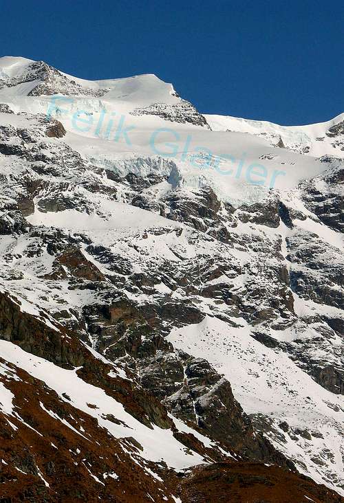
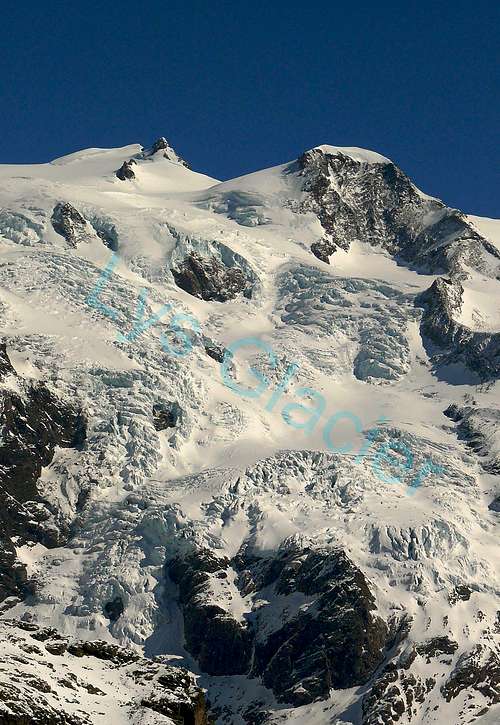
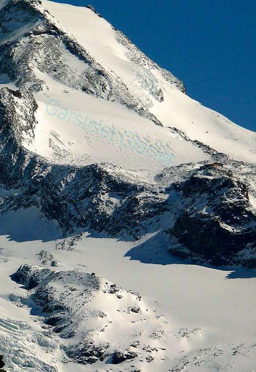
This glacial area begins with the two much larger Eastern and Western Lys Glaciers, at the foot of the cirque between the two Lyskamms, Western and Eastern; over the ice flows descend again in the first direction through the great Eastern branch always Lys, the Garstelet and Endregletscher, which falls between the two pyramids Vincent and the Giordani. Beyond the divide, but this has already been to Piedmont, with glaciers descend, logically, opposite direction but which are not now more part of this study. A small glacier, located between the Pisse Pass and the Northwestern Slope of Stolenberg, almost completely closes the glacial part of the Aosta Valley. In fact, along the ridge dividing the Piedmont find lakes and ponds, among which highlights the Gabiet (2.363m) situated at the foot of the Top of Straling and Corno Rosso (Red Horn), but hardly more ice and you have to get to the Corno Bianco (White Horn), but especially to the Ciampono Summit with Leckenéts Glacier to find two other cirques, even if of limited dimensions.
Analogously, back, on the spur partition with the Ayas Valley: from Gran Sometta and down until the Mount Zerbion above Chatillon and Saint Vincent Municipalities, we will not find more glaciers, while further inland, a more small, said Tzère, fastens, as an appendix, to the Aventine and its waters flow into the underlying Grand Lac, in a small basin enclosed amongst the Bivouac City of Mariano and the Rocca or Mont of Verra(z).

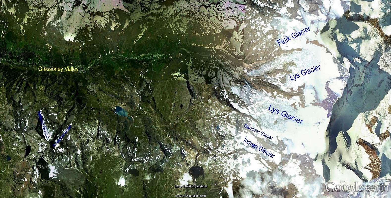
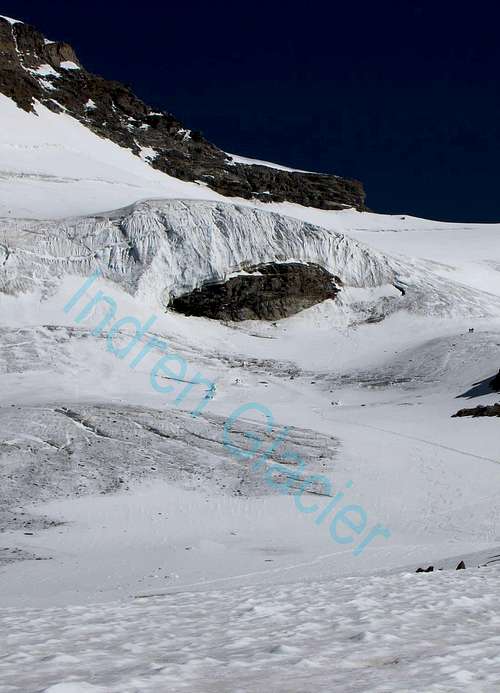
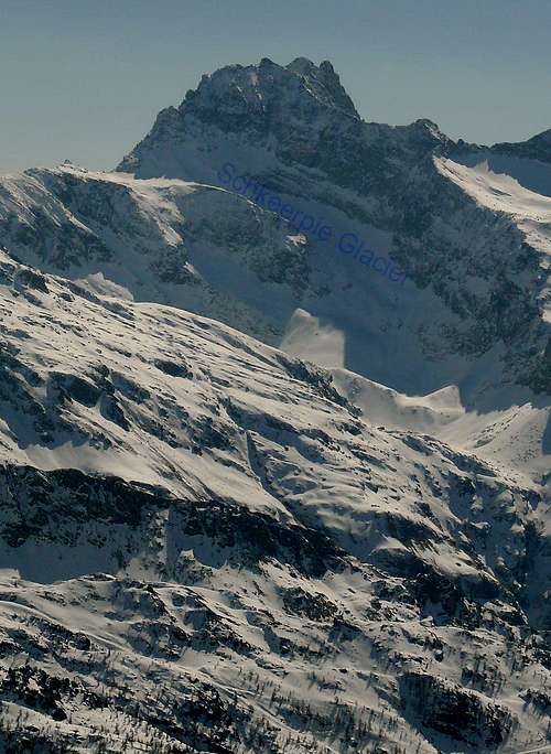
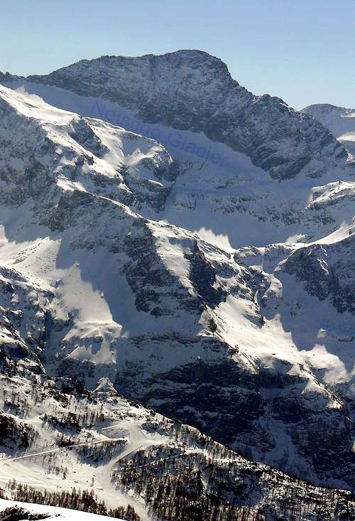
Questo settore glaciale inizia con i due ben più vasti Ghiacciai Orientale ed Occidentale del Lys, ai piedi del circo glaciale tra i due Lyskamms, Ovest ed Est; oltre le colate discendono nuovamente nella prima direzione tramite il grande ramo Orientale sempre del Lys, il Garstelet e l'Endregletscher, discendente tra le due piramidi della Vincent e della Giordani. Al di là dello spartiacque, ma già rivolti al Piemonte, calano ghiacciai con, logicamente, direzione opposta ma che non fan ormai più parte di codesto studio. Un piccolo ghiacciaio, situato tra il Colle della Pisse ed il Versante Nordoccidentale dello Stolenberg, chiude quasi completamente la parte glaciale della Valle d'Aosta. Infatti lungo la cresta divisoria con il Piemonte troveremo laghi e laghetti, tra i quali evidenziasi quello del Gabiet (2.363 m) adagiato ai piedi della Punta di Straling e del Corno Rosso, ma quasi non più ghiacci e si deve arrivare al Corno Bianco, ma soprattutto alla Punta di Ciampono con il Leckenéts Glacier per trovare altri due circhi glaciali, pur se di contenute dimensioni.
Analogo discorso, tornando all'indietro, sul contrafforte divisorio con la Valle d'Ayas: dalla Gran Sometta e giù fino allo Zerbion, sopra Chatillon e Saint Vincent, non troveremo più ghiacciai, mentre, più all'interno, uno più piccolo, detto di Tzère, s'allaccia, come appendice, a quello di Aventine e le sue acque confluiscono nel sottostante Grand Lac, in un ristretto bacino racchiuso tra il Bivacco Città di Mariano e la Rocca o Mont di Verra(z).


Dimensions and mass of glaciers in the Gressoney Valley (Lyskamms - Monte Rosa). The valley has six glaciers as follows:

Dimensioni e massa dei ghiacciai della Valle di Gressoney (Lyskamms - Monte Rosa). La valle possiede sei ghiacciai così ripartiti:


  • 1)   - Felik Glacier
  • 2)   - Lys Glacier
  • 3)   - Garstelet Glacier
  • 4)   - Indren Glacier
  • 5)   - Schkeerpie Glacier
  • 6)   - Netscho Glacier

Felik Glacier

Felik Glacier
Felik Glacier
Felik Glacier


  • Features: Basin
  • Sector: Pennine Alps (Lyskamms - Monte Rosa)
  • Surrounding summits: Punta Felik 4.088m, Punta Perazzi 3.906m
  • Maximum altitude: 4.080m~
  • Minimum altitude: 3.340m~
  • Exposure: S-E
  • Maximum length: 2.150m~
  • Maximum width: 1.400m~
  • Maximum extension: 1,49km²~ 149ha~
  • Mean deep: 25m~*
  • Maximum deep: 40/60m~**
  • Activity: Not sure
  • Mean slope: -
  • Caratteristiche: Bacino
  • Settore: Alpi Pennine (Lyskamms - Monte Rosa)
  • Vette principali: Punta Felik 4.088 m, Punta Perazzi 3.906 m
  • Quota massima: 4.080 m~
  • Quota minima: 3.340 m~
  • Esposizione: S-E
  • Lunghezza massima: 2.150 m~
  • Larghezza massima: 1.400 m~
  • Estensione massima: 1,49 km²~ 149 ha~
  • Profondità media: 25 m~*
  • Profondità massima: 40/60m~**
  • Attività: Incerta
  • Inclinazione media: -

Lys Glacier

Lys Glacier
Lys Glacier
Lys Glacier


  • Features: Basins, stepped and seracs
  • Sector: Pennine Alps (Lyskamms - Monte Rosa)
  • Surrounding summits: Lyskamms 4.481m/4.527m, Corno Nero 4.322m, Piramide Vincent 4.215m
  • Maximum altitude: 4.520m~
  • Minimum altitude: 2.460m~
  • Exposure: S
  • Maximum length: 5.750m~
  • Maximum width: 4.800m~
  • Maximum extension: 12,5km²~ 1250ha~
  • Mean deep: 60m~*
  • Maximum deep: 140/200m~**
  • Activity: Stable
  • Mean slope: -
  • Caratteristiche: Bacini a gradoni e seraccate
  • Settore: Alpi Pennine (Lyskamms - Monte Rosa)
  • Vette principali: Lyskamms 4.481 m/4.527 m, Corno Nero 4.322 m, Piramide Vincent 4.215 m
  • Quota massima: 4.520 m~
  • Quota minima: 2.460 m~
  • Esposizione: S
  • Lunghezza massima: 5.750 m~
  • Larghezza massima: 4.800 m~
  • Estensione massima: 12,5 km²~ 1250 ha~
  • Profondità media: 60 m~*
  • Profondità massima: 140/200 m~**
  • Attività: Stabile
  • Inclinazione media: -

Garstelet Glacier

Garstelet Glacier
Garstelet Glacier
Garstelet Glacier


  • Features: Uncertain
  • Sector: Pennine Alps (Lyskamms - Monte Rosa)
  • Surrounding summits: Piramide Vincent 4.215m
  • Maximum altitude: 3.700m~
  • Minimum altitude: 3.510m~
  • Exposure: S
  • Maximum length: 500m~
  • Maximum width: 350m~
  • Maximum extension: 0,14km²~ 14ha~
  • Mean deep: -
  • Maximum deep: -
  • Activity: Not sure
  • Mean slope: -
  • Caratteristiche: Incerte
  • Settore: Alpi Pennine (Lyskamms - Monte Rosa)
  • Vette principali: Piramide Vincent 4.215 m
  • Quota massima: 3.700 m~
  • Quota minima: 3.510 m~
  • Esposizione: S
  • Lunghezza massima: 500 m~
  • Larghezza massima: 350 m~
  • Estensione massima: 0,14 km²~ 14 ha~
  • Profondità media: -
  • Profondità massima: -
  • Attività: Incerta
  • Inclinazione media: -

Indren Glacier

Indren Glacier
Indren Glacier
Indren Glacier


  • Features: Basin
  • Sector: Pennine Alps (Lyskamms - Monte Rosa)
  • Surrounding summits: Piramide Vincent 4.215m, Punta Giordani 4.046m
  • Maximum altitude: 4.000m~
  • Minimum altitude: 3.100m~
  • Exposure: S
  • Maximum length: 2.200m~
  • Maximum width: 650m~
  • Maximum extension: 0,79km²~ 79ha~
  • Mean deep: 20m~*
  • Maximum deep: 40/50m~**
  • Activity: Moderate retreat
  • Mean slope: -
  • Caratteristiche: Bacino
  • Settore: Alpi Pennine (Lyskamms - Monte Rosa)
  • Vette principali: Piramide Vincent 4.215 m, Punta Giordani 4.046 m
  • Quota massima: 4.000 m~
  • Quota minima: 3.100 m~
  • Esposizione: S
  • Lunghezza massima: 2.200m~
  • Larghezza massima: 650 m~
  • Estensione massima: 0,79 km²~ 79 ha~
  • Profondità media: 20 m~*
  • Profondità massima: 40/50 m~**
  • Attività: Ritiro moderato
  • Inclinazione media: -

Schkeerpie Glacier

Schkeerpie Glacier
Schkeerpie Glacier
Schkeerpie Glacier


  • Features: Circus Glacier
  • Sector: Pennine Alps (Lyskamms - Monte Rosa)
  • Surrounding summits: Punta di Netscho 3.280m, Punta dell'Uomo Storto 3.015m
  • Maximum altitude: 2.970m~
  • Minimum altitude: 2.880m~
  • Exposure: N-O
  • Maximum length: 310m~
  • Maximum width: 180m~
  • Maximum extension: 0,035km²~ 3,5ha~
  • Mean deep: -
  • Maximum deep: -
  • Activity: Not sure
  • Mean slope: -
  • Caratteristiche: Ghiacciaio di circo
  • Settore: Alpi Pennine (Lyskamms - Monte Rosa)
  • Vette principali: Punta di Netscho 3.280 m, Punta dell'Uomo Storto 3.015 m
  • Quota massima: 2.970m~
  • Quota minima: 2.880m~
  • Esposizione: N-O
  • Lunghezza massima: 310 m~
  • Larghezza massima: 180 m~
  • Estensione massima: 0,035 km²~ 3,5 ha~
  • Profondità media: -
  • Profondità massima: -
  • Attività: Incerta
  • Inclinazione media: -

Netscho Glacier

Netscho Glacier
Netscho Glacier
Netscho Glacier


  • Features: Circus Glacier
  • Sector: Pennine Alps (Lyskamms - Monte Rosa)
  • Surrounding summits: Punta di Netscho 3.280m, Punta Ciampono 3.233m
  • Maximum altitude: 3.050m~
  • Minimum altitude: 2.870m~
  • Exposure: N-O
  • Maximum length: 650m~
  • Maximum width: 190m~
  • Maximum extension: 0,079km²~ 7,9ha~
  • Mean deep: -
  • Maximum deep: -
  • Activity: Not sure
  • Mean slope: -
  • Caratteristiche: Ghiacciaio di circo
  • Settore: Alpi Pennine (Lyskamms - Monte Rosa)
  • Vette principali: Punta di Netscho 3.280 m, Punta Ciampono 3.233 m
  • Quota massima: 3.050 m~
  • Quota minima: 2.870m~
  • Esposizione: N-O
  • Lunghezza massima: 650 m~
  • Larghezza massima: 190 m~
  • Estensione massima: 0,035 km²~ 3,5 ha~
  • Profondità media: -
  • Profondità massima: -
  • Attività: Incerta
  • Inclinazione media: -


*The datum is not very sure **Not safe datum
*Dato poco sicuro **Dato non sicuro

Essential BOOKS

  • "Le Pays de la Doire et son Peuple" di Augusta Vittoria Cerutti, Musumeci Editeur, Juin 1995.

External Links

Acknowledgements

I am very grateful to my friend Osvaldo Cardellina for the text and the English translation.