
|
|
Area/Range |
|---|---|
|
|
45.87615°N / 7.96646°E |
|
|
Hiking, Mountaineering, Big Wall, Scrambling |
|
|
Spring, Summer, Fall, Winter |
|
|
9724 ft / 2964 m |
|
|
Overview
During its journey from the ice fields of the South face of Monte Rosa toward the small city of Borgosesia, Sesia river picks up the waters of numerous feeders.The most important of these is surely Sermenza creek, that flows into Sesia near the village of Balmuccia.
The watershed between the valleys of these two rivers is the range of Tagliaferro(2964m).
From Balmuccia this massive ridge climbs toward NW till the North summit of Corno Piglimò, where it joins the great Dorsal that from the top of Monte Rosa divides Valsesia from Val D’Ossola, the two most important areas of the NW of Piedmont, till the lovely Orta lake.
Gneiss is the main rock of this range, the high flanks of the mountains hang over strict valleys with cliffs and colouirs often covered by vegetations, and in the past it was not unusual for the villages of this area to remain isolated for big avalanches and land slides.
The thick vegetation that covers these peaks is due the dampness that from the big planes and lakes of the NW of Italy arises toward North and collides against their ridges causing frequent rain falls in Spring and Summer.
The principal possibilities in the area are for hikers and trekkers, the climbers can find some classical routes on the walls and ridges of Tagliaferro and of Punta Giacomo Chiara. The most of the trails can be used during winter for ski-mountaineering.
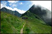
The environment is very savage, often the trails near the minor summits at south are hided by the vegetation, anyhow during the last years several paths and huts have been fixed, especially those of the major passes that was once used by local people to cross from a valley to another, starting from these trails you can then venture toward the summits, often in complete solitude, except for ibexes, alpine goats and other wild inhabitants.
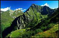
 Corno Mud, Tagliaferro and Carnera from West
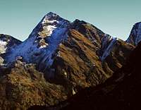
 Carnera, Tagliaferro and Corno Mud from East
Probably some of the summits of this range don’t get visits for years, especially the minor ones at south.
The access from the West side, in particular from the hanging valleys of the southern feeders of Sermenza , above the village of Fervento, can be a real challenge due to the wilderness of the slopes, to their steepness and to the abundance of vegetation.
The only frequented trails are those to Cima Sajonchè, starting from Mollia, in Val Grande, or from Fervento. Some of the trails that above Piode and Scopello can be very pleasant in the days of Autumn or of early spring.
the paths near the main summits at North are instead more easy to find and to scramble on, especially those of the passes that connect Rima to Alagna, the most important localities at the feet of these mountains.
Like it was said above during winter and spring the most of the trails that in the summer are interesting for hikers can become lovely, and often very long, routes for ski-mountaineers.
A classical one leads to Little Altar pass(2624m) from the village of Rima(1411m). Sadly Tullio Vidoni, a strong Italian mountaineer, died for an avalanche on this same route. A small memorial is still visible under the pass, where the obscure North face of Tagliaferro, climbed for the first time during winter by Tullio with other mountaineers of the area, seems to watch over.
 |  |  |  |  |
Getting There
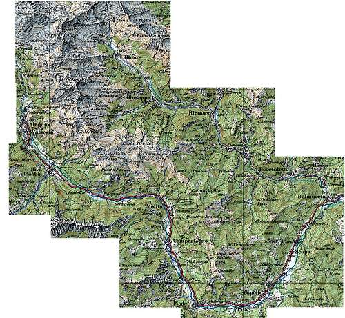
From the highway A26 take the exit of Romagnano Sesia then follow the main road of Valsesia till Balmuccia.From here take the local road of Valsermenza to reach the trailheads for approaching the group from East or go on along the main road for the trailheads at west of the main ridge.
The Major villages that can be used as support are Mollia, Riva Valdobbia and Alagna in the valley of Sesia, and Rimasco, Fervento, San Giuseppe and Rima in the valley of Sermenza.
Red Tape
No permissions are required. You can venture through these peaks whenever you want.Huts
Alpe Sajonchè(2047m). A small building at the pass called ‘Sella alta’ on the routes that connect Mollia on the Shore of Sesia to Fervento in the valley of Sermenza.Useful as support point for the southern summits of the range expecially for Punta Sajonchè.
Alpe Sattal and Alpe Campo(2000m). On the western slopes of Mount Carnera, reachable by the locality Pedemonte, a few kilometers at north of Alagna.
Useful to climb Tagliaferro and Carnera.
Ferioli hut(2426m). Near Mud pass, on the route that connect Alagna to Rima, under the massive N-NW ridge of Tagliaferro.
Usefull to climb Tagliaferro and Corno Mud. The trailhead is Pedemonte like for Alpe Sattal.
Pastore hut(1675m). In the High Valsesia park, the trailhead is the locality called ‘Acqua Bianca’, White waters in English, at the end of the main road of Valsesia, under the huge soth face of Monte Rosa.
Useful to approach from West Corno Piglimò and Corno Mud.
Axerio hut. At the ‘Little altar pass’(2600m) at the basis of the East ridge of Piglimò.
This is just an old building that you can use in case of emergence.
You can get ther from Rima following the trail to little Altar.
 |  |  |
Most interesting summits
Moving from Balmuccia till the summit of Corno Piglimò these are the most important summits of the group at south:Cima Massarei 1571m, Punta delle Balme 1930m, Quattro Bricchi 1979m., Cima Sajonchè 2344m, Cima Tirette 2381m, Cima delle Croci 2408m, Punta Parete 1980m.
These summits belong to a very savage mid-mountain environment where it's easy to loose the trail among the vegetation, especially on the side of Sermenza valley where their flanks sink in the groove of deep valleys that astonish the visitor for the intense green coulor that dominates everywhere. San Giuseppe and Fervento are the villages from where you can start to venture in this area.
On the side above Sesia river the slopes are steeper and they seems to fall directly above the main road of the valley. There are some good marked trail above the village of Mollia.
The last four summits at north are instead more easy to approach, thanks also to their major elevation that makes part of their flanks free from high vegetation.
The highest and most important is Tagliaferro, 2964m, a spectacular rocky peak that overtops the area and seems to threaten the villages of Rima and alagna from Above. Its north west ridge and its north wall are two spectacular sculpture of rocks, but they are not frequently climbed, especially the severe wall. The rocks are firm but they are often covered by slippery vegetation. The normal route doesn't require climbing skills but just trained legs.
Corno Mud, 2804m, is often climbed from Ferioli hut for the magnificent view that offers. An easy ridge reaches the summit from the hut with a prominence of 600 meters. Carnera, 2746m, and Corno Piglimò, 2830m, are instead rarely climbed, especially Carnera, for which the argument about the wilderness of the southern summits is still valid.
The South shoulder of Piglimò, known as Punta Giacomo Chiara offers an interesting rock climbing route on the East Buttress.
external links
Valsesiaofficial site of the mountain community of this area.
CAI Varallo Sesia
Official site of the detachment of Varallo of the Italian Alpine Club.
Alagna
Site of this famous locality. Useful informations about trails, huts and accomodations.
Sajonchè
Informations about Sajonchè hut.
LINAlpe Sattal
Official site of Alpe Sattal. Informations, phone numbers and fancy images.
Ferioli hut
Informations about Ferioli hut.
Pastore
Informations about Pastore hut.