


-
 6449 Hits
-
 80.49% Score
-
 12 Votes
|
|
Area/Range |
|---|---|
|
|
45.86920°N / 7.17109°E |
|
|
Hiking, Mountaineering, Trad Climbing, Sport Climbing |
|
|
Spring, Summer, Fall, Winter |
|
|
8035 ft / 2449 m |
|
|
Note
La montagna chiama i suoi figli, ed essi rispondono fedelmente al suo appello… Osvaldo Cardellina, Diario alpinistico, 1964-65 Page texts: @ OsvaldoCardellina "Osva", passed away on May 2, 2022. Page owners: Christian Cardellina e Osvaldo Cardellina. Any updates from September 12, 2022: Antonio Giani, page administrator, friend and climbing companion. Testi della pagina: @ OsvaldoCardellina "Osva", scomparso il 2 maggio 2022. Proprietari pagina: Christian Cardellina e Osvaldo Cardellina. Eventuali aggiornamenti dal 12 settembre 2022: Antonio Giani, amministratore della pagina, amico e compagno di salite. |
Overview
Gran San Bernardo Valley-Basin. This large valley shaped foam basin looming over the Municipalities of Gignod, Etroubles, St. Oyen and St. Rhémy-en-Bosses, it extends first to the North and then North-northwest for 34 km. from the City of Aosta (583m) to the Great St. Bernard Pass (2.449m), now completely in Switzerland. But the "real" Valley begins just before the Municipality of Saint Rhémy-en-Bosses (1.619m; at Km. 23, after the unification of the two Communes), while at the bottom we have the stretch with Shared Basin By, the Valpelline and the subsequent diversion to the Ollomont Valley, the latter like a bridge between the other two. At Km. 18.2 the SS.27, after the Municipality of St.-Oyen (1.373m), leaving to the West entrance to the Motorway of the Gran San Bernardo and the surroundings of the former Common of Bosses at the entrance of 'the same name that Comba, followed by the subsequent "Combe du Merdeux", reaches Col Malatrà (2.928m), on the border with the Italian Val Ferret. From Saint Rhémy-en-Bosses valley completes its sinuous form topographically returning permanently to the North until you reach the Colle, located between Grande and Petite Chenalette (2.664m, 2.890m) to the West and the Mont Mort (2.928m) in the East. From this the border ridge continues in this direction until you reach the last Mont Velan (3.734m); by this long spur descends South until you reach, after the great pyramid of Salliaousa (3.203m), the rounded Mont Saron or Mont-Champ-Rion (2.681m), above the Commons of Allein also Allain (1.251m) and Doues (1.176m, 9 Km. from Aosta), more in the Southeast. This divides the small Valleys Menouve Molline to the West, still belongs to the Valley of the Gran San Bernardo, the great Basin By at the foot of the Southern Wall of Velan same. Other secondary valleys unfold by the Municipality of Gignod to the west-southwest (Arpeilles, Buthier, Arsy, Flassin, Citrin and Serena) until it joins the Combe du Merdeux; these make up the orographic and hydrographic South Valley, separated from them by Torrent or Rio of Artanavaz, also called Buthier de Bosses, the waters of which are combined with those of the Buthier of Valpelline at the Villages of Moulin and Rovin (826m). In fact this last stretch from Rovin or Roven Aosta has been called since ancient times as the "Mère des Rives", that means, along with those that descend from Valpelline, the "Mother of all Waters"; along the upper reaches to the Aiguille d'Artanavaz (3.071m) reaches a length of 22 Km. from Aosta. On the opposite bank, starting from the Municipality of Roisan (833m), instead opening the Northeast long Valpelline reaching Dent d'Hèrens and "Les Grandes Murailles". So, analyzing everything from a hydrographical point of view, this valley is unique, as the waters coming together form the generic Torrent Buthier (from the Celtic bu or lye or boud that is bubbling, or by place names Latin Buthiacus and Bautegius, while in the Middle Ages was called also Balteus), who joins the Dora Baltea near the Eastern Aosta Town. So if the third partition in terms of basin is not correct, is also to be considered arbitrary and anachronistic the reunification of the three areas that remain for us, as tradition and history not only geographical, Valley of the Gran San Bernardo, the By Basin with Ollomont small Valley and Valpelline. In this paper we analyze the first with its Southern branches and appendages and the neighboring Western "Combe du Merdeux" that extend progressively to the Northwest by Gignod towards the extreme Malatrà Hill.
![]()
![]()
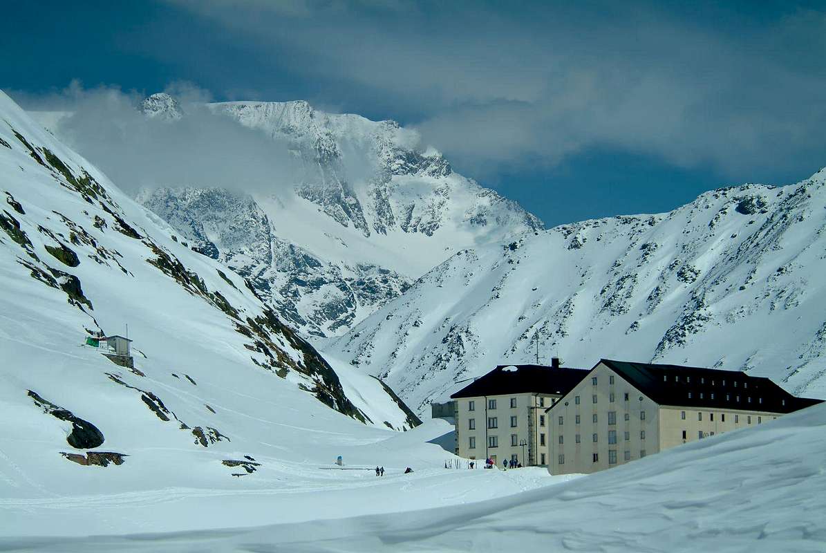
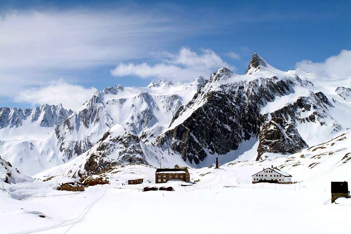
The Hospice, the Morgue, "Vallon des Morts", the Smugglers of cigarettes-chocolate and the Tunnel The Hospice is properties of Monks St. Bernard, Rule of St. Augustine, built "ab immemorabilis" above a statue dedicated to Jupiter, while the actual statue of San Bernardo was inaugurated in 1905; in the Church are the relics of St. Faustina taken from the Roman catacombs and donated in 1828 by Pope Leo XII° to the Hospice. A "latere or fringes" of an ancient tombstone II°/III° Century that reads "Faustina dulcis anima or Faustina sweet soul". Moreover immediately behind is the ancient "Morgue", where the dead were withheld until the spring waiting for proper burial; many deaths occurred because of avalanches in an attempt to force a passage in the middle of winter between high and perilous snow. That occurred often in the "Vallon des Morts" and who registered even recently, is also in 2015 against three Ski-Mountaineers, while in the past mainly affecting Cigarette Smugglers and Pilgrims. This valley, which opens at the end of the Val d'Entremont and the foot of the Northern Slope of Mont Mort, has a sad history, as incidentally configures his name. His "fame" of harvester victims" were not immune from the Monks of the Hospice, yet well acquainted with the area and its inherent dangers. Incidentally, going from the Valley of Entremont (Lake Mauvoisin and Bourg St. Bernard) is very easy in the event of snow, or worse in the presence of fog, near Le Tronchet, keeping too much to the left (East), to "squeeze into this gut" made up of the Combe de Barasson, then sadly dubbed with the name of "Vallon des Morts". Or alternative choice for the hill, especially to evade surveillance, aiming for one of the two Barasson Passes riding homonymous Tête (2.730m), which enable the descent to St. Rhémy (the West) and St. Oyen. A passage already frequented by the Romans and, as we shall see, by many others along with the most Eastern Hills Menouve or Menovy, Molline and Hannibal, while on the other side (West), coming from the Swiss Val Ferret, had used the Col Fenêtre d'en Haut or of Fonteinte and the nearby Tête de Ferret. This series of alternative steps leads respectively in Etroubles, St. Rhémy and Bosses and have a long, colorful history and romanticized until years 1950/60, made of escapes and pursuits among Smugglers of cigarettes with their baskets overloaded and Bodies Police State. Then the opening of the Tunnel with the initial project of 1839 for rail traffic, works to start in 1958 and inaugurated in March 19th, 1964 with a length of 5.798 meters, width of 4,50 meters with the two respective sidewalks of 0,90 metres and a transit capacity of 500 vehicles per hour in both directions, between the Municipalities of Bosses in Italy and Bourg St. Bernard in Switzerland) and the gradual devaluation of the lira against the Swiss Mark have reduced the phenomenon, which in addition to cigarettes also facing the famous and renowned chocolate, in practice by canceling the problem.
![]()
L'Ospizio, la Morgue, il "Vallon des Morts", i Contrabbandieri di sigarette e cioccolato ed il Traforo Costruito proprio al valico é di proprietà dei Monaci, Regola di Sant'Agostino; eretto "ab immemorabilis" sopra d'un simulacro dedicato a Giove, mentre la statua attuale di San Bernardo é stata inaugurata nel 1905. Nella Chiesa vengono conservate le reliquie di Santa Faustina prelevate dalle catacombe romane e donate nel 1828 da Papa Leone XII° all'Ospizio. A "latere" un'antica lapide del II°/III° Secolo che recita "Faustina dulcis anima". Subito dietro trovasi l'antica "Morgue", ove venivano trattenuti i morti insino a primavera in attesa d'adeguata sepoltura. Molti decessi avvenivano a causa di valanghe nel tentativo di forzarne il passaggio in pieno inverno tra alte e perigliose nevi, evento verificatosi anche recentemente (2015) nell'adiacente "Vallon des Morts" nei confronti di tre Sci-Alpinisti, mentre nel passato colpiva soprattutto Contrabbandieri e Pellegrini. Questo vallone, che si apre al termine della Valle d'Entremont nonché ai piedi del Versante Settentrionale del Mont Mort, possiede una ben maleaugurata storia, come daltronde ne configura il nome. La sua "fama" di mietitore di vittime" non ha risparmiato neppure i Monaci dell'Ospizio, eppur buoni conoscitori della zona e dei suoi insiti pericoli. Daltronde, salendo dalla Valle di Entremont (Lago di Mauvoisin e Bourg St. Bernard) é alquanto facile in caso di neve alta, o peggio in presenza di nebbia, nei pressi di Le Tronchet, tenendosi troppo a sinistra (Est), di "infilarsi in questo budello" costituito dalla Combe de Barasson, poi tristemente ribattezzato con il toponimo di "Vallon des Morts". Oppure per scelta alternativa al colle, soprattutto per eludere le sorveglianze, mirando ad uno dei due Colli di Barasson a cavallo dell'omonima Tête (2.730 m), tali da permettere la discesa a St. Rhémy (quello Occidentale) ed a St. Oyen. Un passaggio già frequentato dai Romani e, come vedremo, da molti altri insieme ai più Orientali Colli di Menouve o Menovy, Molline e di Annibale, mentre sul lato opposto (Ovest), arrivando dalla Val Ferret svizzera, erano utilizzati il Col Fenêtre d'en Haut o di Fonteinte nonché il vicino Tête de Ferret. Questa serie di passaggi alternativi conducono rispettivamente a Etroubles, St. Rhémy e Bosses e possiedono una lunga, variopinta e romanzata storia fino agli anni 1960/70, fatta di fughe e di inseguimenti tra i Contrabbandieri di sigarette con le loro gerle stracariche ed i Corpi di Polizia di Stato. Poi l'apertura del Tunnel con progetto iniziale del 1839 destinato al traffico ferroviario, inizio dei lavori nel 1958 ed inaugurazione del 19 Marzo 1964 per una lunghezza di 5.798 metri, larghezza di 4,50 metri con due rispettivi marciapiedi di 0,90 metri ed una capacità di transito di 500 veicoli all'ora nei due sensi, tra i Comuni di Bosses e Bourg St. Bernard) e la progressiva svalutazione della Lira nei confronti del Marco Svizzero hanno ridimensionato il fenomeno, che oltre alle sigarette riguardava anche il cioccolato, in pratica annullando il medesimo.
![]()
The St. Bernard Dog, Hannibal with the Elephants, Napoleon and the Snow
![]()
I Cani San Bernardo, Annibale con gli Elefanti, Napoleone e la Neve ![]()
From the II° Punic War and the Romans to the Routes "Francigena and Napoleonic" ![]()
![]()
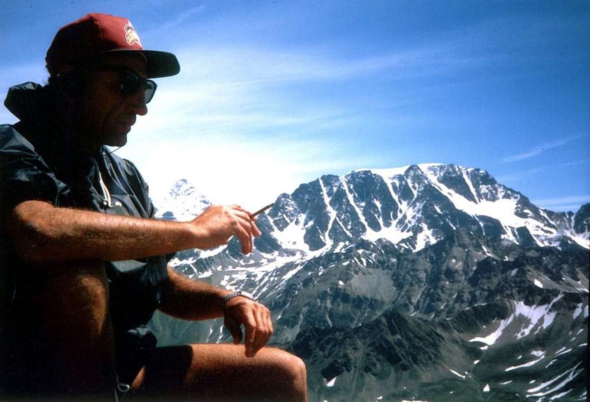
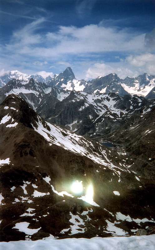
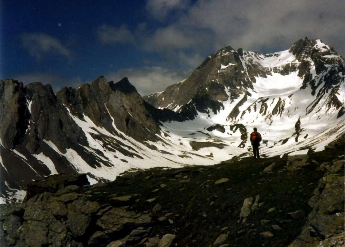
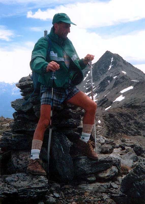
After the Pilgrims, the "Soldats de la Neige" and finally the Wayfarers & Mountaineers looking Velan and the Combins ![]()
![]()
Dopo i Pellegrini, les "Soldats de la Neige" e da ultimo Viandanti ed Alpinisti guardando Velan ed i Combins
![]()
VALLEYS & VALLONS In order to deploy clockwise from Aosta Town in Central Baltea Valley towards the Great Saint Bernard Valley
Valle del Gran San Bernardo. Questa grande vallata a forma di espanso bacino sopra i Comuni di Gignod, Etroubles, St. Oyen e St. Rhémy-en-Bosses, si estende dapprima verso Nord e poi Nord-nordovest per 34 Km. dalla Città di Aosta (583 m) fino al Passo del Gran San Bernardo (2449 m), ormai completamente in territorio svizzero. Ma la "vera" valle inizia appena prima del Comune di Saint Rhémy-en-Bosses (1.619 m; al Km. 23, dopo l'unificazione dei due Comuni), mentre nella parte inferiore abbiamo il tratto in Comune con la Conca di By, la Valpelline e la successiva deviazione verso la Valle di Ollomont, quest'ultima a guisa di trait d'union tra le altre due. Al Km. 18,2 la SS.27, dopo il Comune di St.-Oyen (1.373 m), lascia verso Ovest l'ingresso per il Traforo con Autostrada del Gran San Bernardo, nonché le frazioni dell'ex Comune di Bosses all'ingresso dell'omonima Comba che, seguita dalla successiva "du Merdeux", raggiunge il Col Malatrà (2.928 m), ai confini con la Val Ferret italiana. Da Saint Rhémy-en-Bosses la valle completa la sua forma topograficamente sinuosa ritornando definitivamente verso Settentrione fino a raggiungere il Colle, sito tra Petite e Grande Chenalette (2.664 m, 2.890 m) ad Ovest ed il Mont Mort (2.928 m) ad Oriente. Da qui la cresta di confine prosegue in quest'ultima direzione sino a raggiungere, dopo i due Colli Occidentale ed Orientale, la Punta di Barasson (2.963 m), Mont Menouve e Tête Grise la calotta ghiacciata del Velan (3.734 m), donde un lungo contrafforte scende verso Sud a raggiungere, dopo la bella piramide della Salliaousa (3.203 m), il tondeggiante Mont Saron o Mont-Champ-Rion (2.681 m) sopra il Comune di Allein o Allain (1.251 m) a Sud e quello di Doues (1.176 m, 9 Km. da Aosta) più a Sudest. Questo divide la Val Menouve-Molline ad Ovest, ancora appartenente a quella del Gran San Bernardo, dalla grande Conca di By, ai piedi della Parete Meridionale del Mont Velan medesimo. Altri valloni secondari si dispiegano dal Comune di Gignod verso Ovest-sudovest (Arpeilles, Buthier, Arsy, Flassin, Citrin e Serena) fino a congiungersi con la Combe du Merdeux. Questi costituiscono il lato orografico ed idrografico Meridionale della valle, separata dallo scorrere del Torrent o Rio d'Artanavaz, detto anche Buthier de Bosses, le acque del quale si congiungono con quelle del Buthier di Valpelline presso i Villaggi di Moulin e Rovin (826 m). In effetti quest'ultimo tratto da Rovin o Roven ad Aosta é stato chiamato da tempi molto antichi come la "Mère des Rives", tale da significare, insieme a quelle che scendono dalla Valpelline, la "Madre di tutte le Acque"; insieme al tratto superiore fino all'Aiguille d'Artanavaz (3.071 m) raggiunge una lunghezza di ben 22 Km. da Aosta. Sulla sponda opposta, partendo dal Comune di Roisan (833 m) s'apre invece a Nordest la lunga Valpelline che raggiunge "Les Grandes Murailles". Quindi, analizzando il tutto da un punto di vista idrografico, questa valle risulta unica, poiché le acque riunendosi formano il generico Torrent Buthier (dal celtico bu o liscivoso oppure boud cioé gorgogliante; oppure dai toponimi latini Buthiacus e Bautegius, mentre nel Medioevo era chiamato anche Balteus), che s'unisce alla Dora Baltea presso Aosta. Quindi se la suddivisione in tre parti dal punto di vista idrografico non risulta corretta, altresì é da considerarsi arbitraria ed anacronistica la riunificazione delle aree che rimangono, come da tradizione e storia non solo geografica, la Valle del Gran San Bernardo, la Conca di By con la Valle d'Ollomont nonché la Valpelline. In questo analizzeremo la prima con le diramazioni Meridionali e la limitrofa "Combe du Merdeux", estendentisi progressivamente a Nordovest dal Comune di Gignod e fino all'estremo Col Malatrà, prima del Gruppo Grand Golliaz (3.237 m).
But the Valley of San Bernardo is also famous for other reasons:
Ma la Valle del San Bernardo é famosa anche per altri motivi:
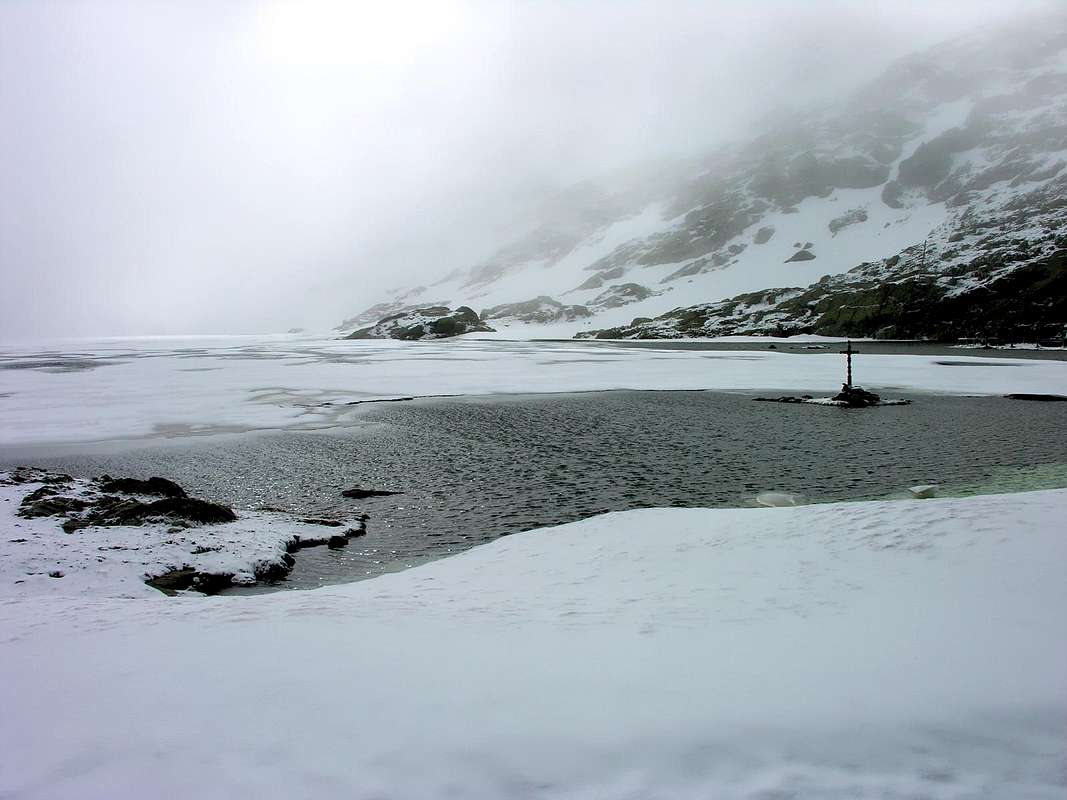
So Snow has always been the undisputed Queen of Pass: it has affected the lives of Pilgrims, Smugglers, Forces of Guardia di Finanza, Monks and even the Armed groped in the transition from Switzerland to Italy. By Hannibal during the Punic Wars to Napoleon I° that 14th to 20th May 1800, during the First Italian Campaign, passed it along to the General Marescot with 35,000 men, 3,500 horses and 40 artillery pieces. Hannibal, with its Elephants, will have rehearsals with the discovery near the "Hill of Hannibal" by the Historical Mountaineer Guido Cibrario in 1901 of a spearhead Carthaginian long 22 cm. Clearly for an Army cross the Gran San Bernardo meant, in addition to the main hill, exploiting all other contiguous. The dogs came after, the snow always. In 1866 the lake has not thawed even in the height of summer and in August 1880 fell 60 cm of snow, in 1897 11 meters with a temperature of 32 degrees below 0, beat record in 1908 with 14 meters. With regard to the St. Bernard Dog, the true breed is extinct in 1813 of natural causes (illnesses, including the one that hit the eyes), It is mentioned in documents of 1540 and an English Lord had one in 1618. The breed current is a cross between that of Newfoundland and the Race Wurthemberg, but for the true origins of the race, you have to refer to the large mastiffs of the Roman Legions, left the troops intended to guard strategic points on major roads. This is the probable origin of the dogs of St. Bernard and the great Cattle widespread in many Swiss cantons; the earliest documentation of the presence of the Colle San Bernardo, then Col Mons Jovis, from the second half of the '600, when the Neapolitan painter Salvator Rosa drew a large mastiff similar to the modern Saint Bernard dog. The first dogs, not identifiable with the actual race but with the late mastiff Alpine, were donated to the canons residents at the hospice situated on the Colle San Bernardo in 1660, by the noble families of the Valais, to guard and protect the hospice by bandits, but also for many other uses, the transport of agricultural products in milk and cheese, the driving force of the mills, operated by dogs, moved the spit of the kitchen. The commitment that made them famous in the world was for helping the monks or Marronnier mark trails in the deep snow, predict avalanches and finding lost travelers in bad weather. The most famous was Barry I (1800-1814), hero of the rescue of at least 40 people. At death, he was embalmed and kept at the Natural History Museum of Berne; since then the best male of each litter at the Hospice called Barry. In addition, race, up to that time known as "Hound of the Alps", began to spread like Chien Barry. The name Saint Bernard dog, relative and dedicated to the Saint of Aosta, was used for the first time in 1862, at exhibitions dog-loving at Birmingham City, and became common in the 1880s. Other illustrious names among St. Bernard Dogs were the giant Tom, 1,30 meters high, the female Diana in 1902 saved in one day three people, Leo and Gal, the last of the ancient race. Features? Short hair and very thick hazel with white spots and with the inseparable small barrel with liquor, his neck, on which hang, like the eyes, tufts blackish. Also infinite Love for duty, the master and children.
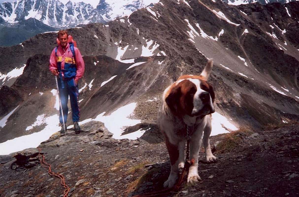
Quindi la Neve é sempre stata la regina incontrastata del Valico: essa ha condizionato la vita di Pellegrini, Contrabbandieri, Forze della Guardia di Finanza, Monaci ed anche di Armate nel tentare il passaggio dalla Svizzera all'Italia. Da Annibale durante le Guerre Puniche a Napoleone I° che dal 14 al 20 Maggio 1800, durante la Prima Campagna d'Italia, lo passò insieme al Generale Marescot con 35.000 uomini, 3500 cavalli e 40 pezzi di artiglieria. Di Annibale, con gli Elefanti, si hanno le prove con il ritrovamento al vicino "Colle d'Annibale" da parte dello Storico Alpinista Guido Cibrario nel 1901 di una punta di lancia cartaginese lunga 22 cm. Chiaramente per un Esercito valicare il Gran San Bernardo significava, oltre al colle principale, sfruttare tutti gli altri attigui. I cani sono venuti dopo, la neve da sempre. Nel 1866 il lago non si é sgelato neppure in piena estate e nell'Agosto del 1880 caddero 60 cm, nel 1897 11 metri con temperatura di 32° sotto lo 0, record battuto nel 1908 con 14 metri. Per quanto concerne i Cani del San Bernardo, la vera razza si é estinta nel 1813 per cause naturali (malattie, compresa quella che colpiva gli occhi), Si trova citato in documenti del 1540 ed un Signore Inglese ne possedeva uno nel 1618. La razza attuale risulta un incrocio tra quella di Terranova e la Razza Wurthemberg, ma per le vere origini della razza, si deve fare riferimento ai grossi mastini delle Legioni Romane, lasciati alle truppe destinate a presidiare i punti strategici sulle grandi vie di comunicazione. Probabile questa l'origine dei cani di San Bernardo e dei grandi Bovari diffusi in vari Cantoni svizzeri; la prima testimonianza certa della presenza al Colle San Bernardo, allora Col Mons Jovis, risale alla seconda metà del '600, quando il pittore napoletano Salvator Rosa ritrasse un grosso molossoide simile al moderno cane di San Bernardo. I primi cani, non identificabili con la razza attuale ma con lo scomparso mastino alpino, vennero donati ai canonici residenti presso l'Ospizio situato al Colle San Bernardo nel 1660, dalle famiglie nobili del Vallese, per la guardia e la protezione dell'Ospizio stesso dai briganti, ma anche per numerosi altri impieghi, dal trasporto di prodotti agricoli a latte e formaggi, alla forza motrice dei mulini che, azionato dai cani, muoveva lo spiedo della cucina. L'impegno che li rese celebri nel mondo fu quello di ausiliari dei Monaci o Marronnier nel tracciare la pista nella neve alta, prevedere la caduta di valanghe e ritrovare i viaggiatori dispersi col maltempo. Il più famoso fu Barry I (1800-1814), protagonista del salvataggio di almeno 40 persone. Alla morte, venne imbalsamato e conservato presso il Museo di Storia Naturale di Berna; da allora il miglior maschio d'ogni cucciolata dell'allevamento dell'Ospizio prende il nome Barry. Inoltre, la razza, fino a quel tempo conosciuta come "Mastino delle Alpi", s'iniziò a diffondere come Chien Barry. La denominazione Cane di San Bernardo, dal Santo di Aosta, venne utilizzata per la prima volta nel 1862, in occasione di un'esposizione cinofila presso Birmingham, e divenne comune nel 1880. Altri nomi illustri tra i San Bernardo sono stati il gigantesco Tom, alto 1,30 metri, Diana che nel 1902 salvò in un sol giorno tre persone, Leo e Gal, ultimi dell'antica razza. Caratteristiche? Pelo raso, molto fitto di color nocciola con macchie bianche e con l'inseparabile botticella con liquore, appesa al collo, sul quale pendono, come sugli occhi, ciuffi di pelo nerastro. Inoltre Amore infinito per il dovere, il padrone ed i bambini.
In addition to Hannibal in 218 BC with 20.000 Infantry, 6.000 Cavalery and 37 Elephants, past as well as from Sestriere (Piedmont) also from San Bernardo during the Second Punic War (219-201 BC) are to be entered several passages of Roman Legions: the Consul Cassius Longinus in 105 a. C. to make war against the Tigurini People, Sergio Galba in 55 a. C. with the famous XII° Legion supported by the Cavalry, the Dux Alieno Cécina in 69 a. C. with the Legions of Gaul and Germany to help the Emperor Vitellius against Otto, the Army Longobard in 547 d. C., the Army of Charlemagne in 773, that of Frederick the Barbarossa in 1174 and in 1175 to repatriate him the same in Germany, Amadeus VIII° of Savoy with the heavy Artillery in 1434 etc, etc. But in addition to Duces, Leaders and Generals, have passed also Popes (Stephen II°, Leo IX°, Eugenio III°) and Emperors (Maximilian in 302, Henry IV° with the Empress to get off at Canossa in 1077, Sigismund with 500 Infantrymen and 1000 Knights in 1414) and also the Saints (St. Albano Bishop of Mainz in 390, Epifanio Bishop of Pavia in 494 by the Emperor Theodoric sent to Geneva, St. Mauro disciple of St. Benedict in 547, St. Ulrich Bishop of Augsburg in 971 , St. Malachy Bishop of Armagh and Primate of Ireland, and even St. Francis de Sales, in the storm saved the faithful Rolland who dragged him to the St. Bernard Hospice). Or relics of the same with St. Sebastian Martyr in 826 and in the same year San Marcellino and St. Peter Martyr, said the Exorcist. But the list of the passages becomes infinite in respect of celebrities up to Napoleon Bonaparte (falling with the old mule above a precipice uphill at night and, after He has secretly inspected undercover troops at the Hospice, and down with a naive servant by a great sled to St. Rhémy and Etroubles Hamlets) to go to the Battle of Marengo against the Austrians. But amidst all these "Celebrities & Ups and downs" goes the old "Via Francigena or Franchigene and again Francisca also Romea", which in the Middle Ages joined Canterbury to Rome and to the ports of Puglia on the road to Jerusalem. Traveled by Pilgrims and rediscovered by modern Wayfarers, who are setting out along a beautiful and adventurous but often well marked trail. Since 2001, the European Association of the Via Francigena coordinates the development and enhancement of a route, that crossing all Italy and Europe, traces the history of our Continent. In the Valley of Gran San Bernardo, starting from Gignod Common, it runs through the forest coming nearby to Etroubles Commune, where practically joins to get to the Hill with the "Napoleonic Via", which runs almost entirely the way followed by the Army of the great Corsican Emperor.
Oltre ad Annibale nel 218 a.C. con 20.000 fanti, 6.000 cavalieri e 37 elefanti, passato oltre che dal Sestriere anche dal San Bernardo durante la Seconda Guerra Punica (219-201 a.C.) si devon registrare numerosi passaggi delle Legioni Romane: il Console Cassio Longino nel 105 a. C. per fare guerra ai Tigurini, Sergio Galba nel 55 a. C. con la XII° Legione appoggiata dalla Cavalleria,il Dux Alieno Cécina nel 69 a. C. con le Legioni di Gallia ed Alemania per aiutare l'Imperatore Vitellio contro Ottone, l'Esercito Longobardo nel 547 d. C., l'Armata di Carlo Magno nel 773, quella di Federico il Barbarossa nel 1174 e nel 1175 lui medesimo per rimpatriare in Germania, Amedeo VIII° di Savoia con l'Artiglieria nel 1434 ecc, ecc. Ma oltre ai Duces, Condottottieri e Generali, son transitati anche Papi (Stefano II°, Leone IX°, Eugenio III°) ed Imperatori (Massimiliano nel 302, Enrico IV° con l'Imperatrice per scendere a Canossa nel 1077, Sigismondo con 500 Fanti e 1000 Cavalieri nel 1414) e pure Santi (Sant'Albano Vescovo di Magonza nel 390, Epifanio Vescovo di Pavia nel 494 inviato dall'Imperatore Teodorico a Ginevra, San Mauro discepolo di San Benedetto nel 547, Sant'Ulrico Vescovo di Augsbourg nel 971, San Malachia Vescovo di Armagh nonché Primate d'Irlanda ed anche San Francesco di Sales, salvato nella tormenta dal fedele Rolland che lo trascinò sino all'Ospizio). Oppure reliquie dei medesimi con San Sebastiano Martire nel 826 e nello stesso anno San Marcellino Martire e San Pietro, detto l'Esorcista. Ma l'elencazione dei passaggi diventerebbe infinita a riguardo di personaggi celebri fino a quello di Napoleone Bonaparte (caduto insieme al vecchio mulo in salita su d'un precipizio e sceso di notte e di nascosto con un ingenuo servitore tramite uno slittone fino a St. Rhémy ed Etroubles, dopo avere ispezionato in incognito le truppe presso l'Ospizio) per andare alla Battaglia di Marengo contro gli Austriaci. Ma in mezzo a tutte queste "celebrità & Peripezie" passa l'antica "Via Francigena o Franchigene ed ancora Francisca o Romea", che nel Medioevo univa Canterbury a Roma ed ai porti della Puglia sulla via per Gerusalemme. Percorsa dai Pellegrini e riscoperta dai moderni Viandanti, che si mettono in cammino lungo un percorso splendido ed avventuroso, ma spesso ben segnalato. Dal 2001 l'Associazione Europea delle Vie Francigene coordina lo sviluppo e la valorizzazione d'un itinerario che, attraversando tutta l'Italia e l'Europa, ripercorre la storia del nostro Continente. Nella Valle del Gran San Bernardo, partendo da Gignod, essa attraversa tutta la foresta giungendo ad Etroubles, dove in pratica s'unisce per arrivare al Colle con la "Via Napoleonica", che percorre quasi integralmente la via seguita dall'Armata del grande Corso.
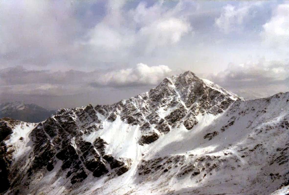
Finally after the Napoleon: by the Bonaparte left an indelible mark in the local population, and even today is done a "Napoleonic Parade" with costumes and weapons Era. Together homonym "Via", the "Francigena", the beautiful, old and with local characteristic masquerades "Carnival of Bosses" (famous for the ham) are the particular features of this valley. imitating Hannibal and the Carthaginians, which have gone missing, the Leader passed in silence: the troops from Martigny reached Liddes the evening of May 15th and the next day they reached the Hospice departments of Infantry, followed in the next two by light artillery and heavy Napoleon with his staff going from Bourg St. Pierre. Taken from the rush to see the crossing of the troops to the hill, he went on alone with his errand boy, risking their lives to the rocks of Sarrière (as would change the History!), But Pierre Nicola Drouaz held both he and the old mule. At 5 pm at the Hospice it was but there was none; the strong and cold wind had "holed up" in all barracks. He stayed in the Hospice for an hour, visiting the library, the museum, the chapel and to the outside the Morgue; then he went down with the slide coming to St. Rhémy and Etroubles amongst the general amazement. Quite different the descent of the army that did such a brothel that rivals Attila "digging a gap" between the villages and the people who passed through; a clamor that fell silent on 19th where he was "stopped out" against the Fortress of Bard up to June 01th, 1800 by 400 soldiers Austro-Piedmontese, who were granted the honors of war. But the "People's Imagination" was hit indelibly and transit in the First Italian Napoleonic Campaign considered heroic and everywhere waving tricolor flags (white, red and blue, of course ...). He was born the "Napoleonic Myth" and many ventured to Colle. For this reason were born "Soldats de la Neige", the local mountain people, almost of the Mountain Guides, who professionally accompanied Wayfarers, Tourists and Pilgrims in the crossing of the same. Going in what until then had been made by Hospice's Monks and Dogs. Later in time they would become Smugglers, because the Hunters were always already. But the Monks had preceded them for quite some time: is August 31th, 1779 when the Monaco Naturalist Laurent-Joseph Murith of the Hospice Gran San Bernardo with the Swiss Hunter Genoud perform the first absolute ascent of Mont Velan (3.734m) through the Northwest Face and the "Hannibal Ridge"; the same will no longer climb up to 1824, ie after the passage of Napoleon.
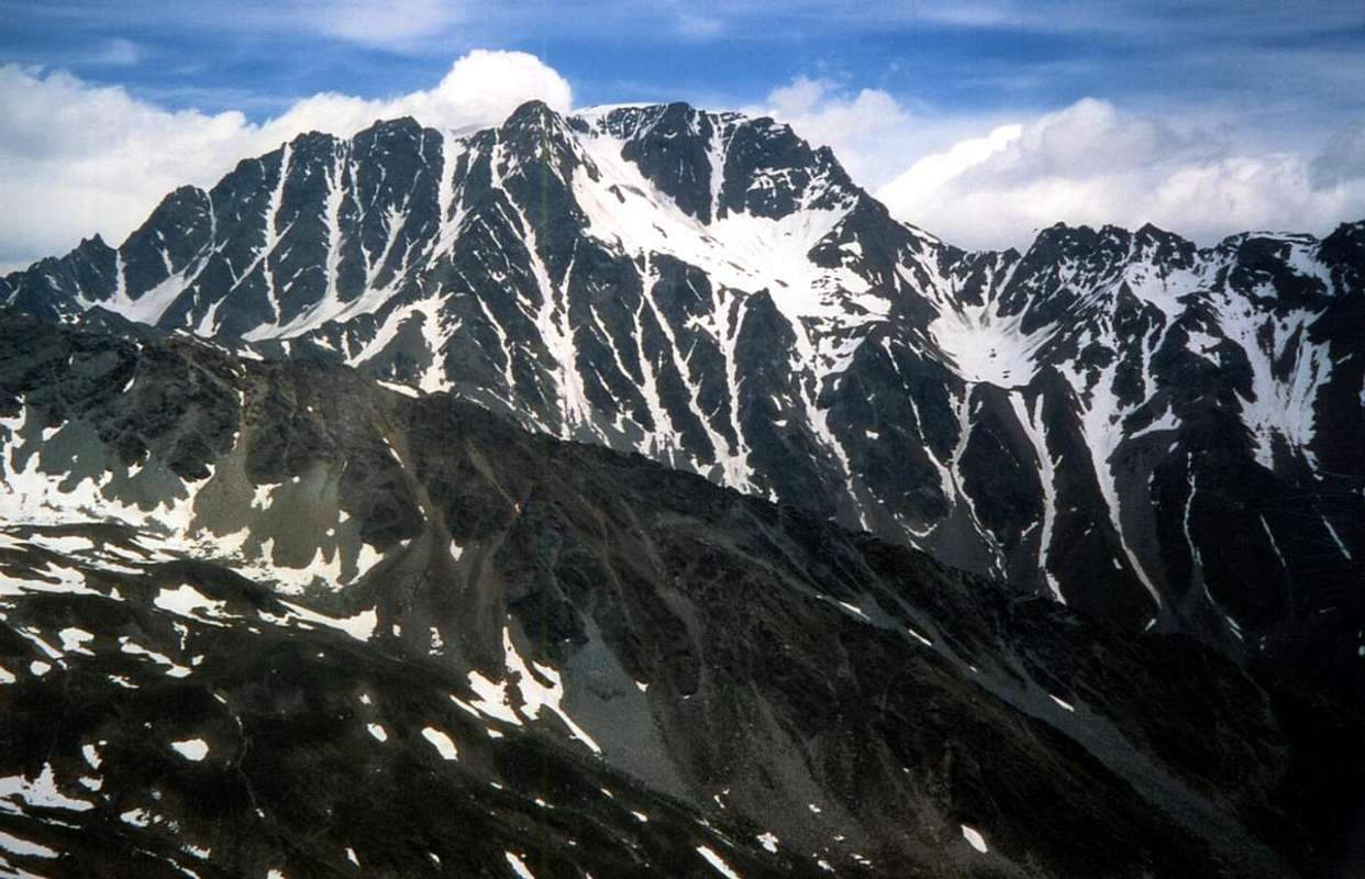
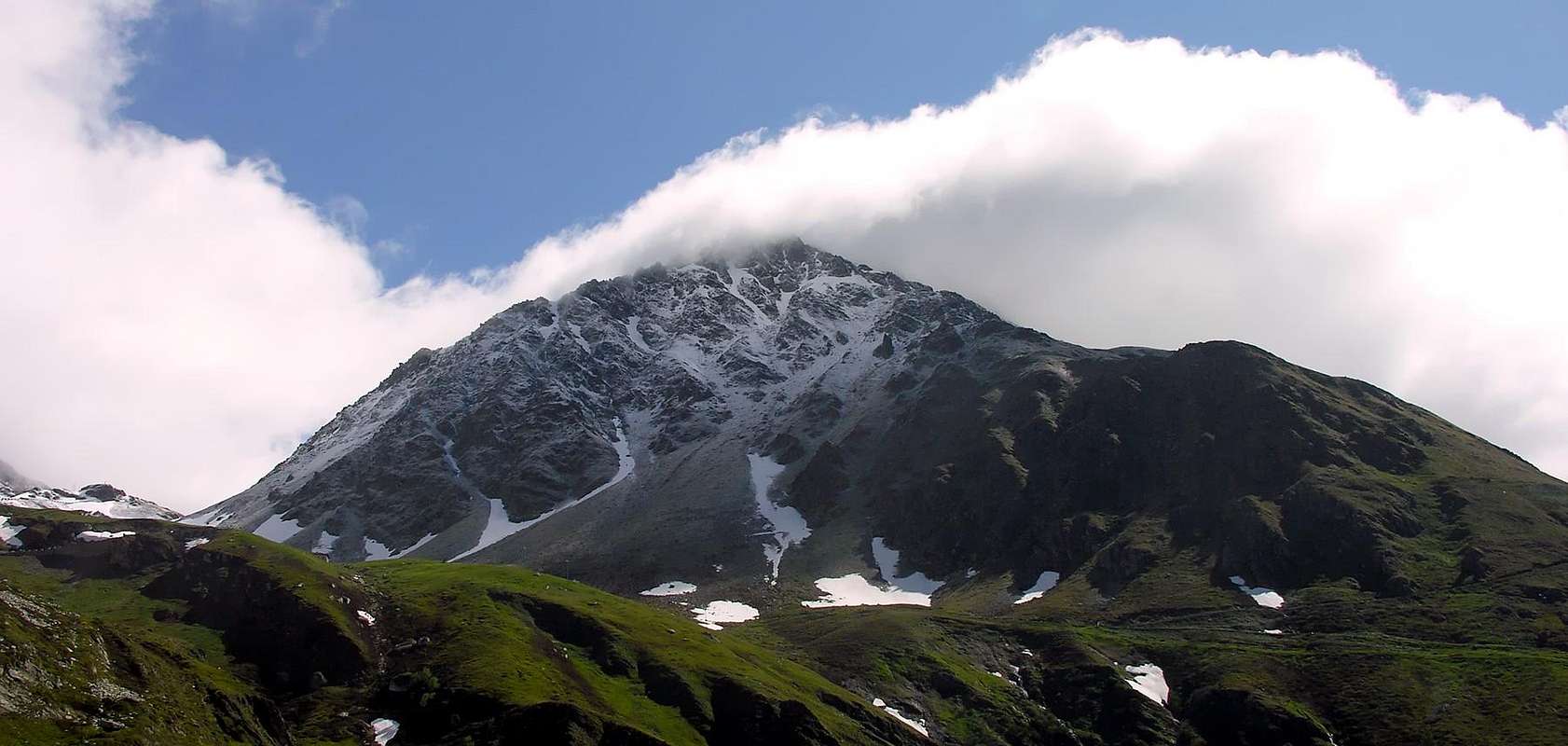
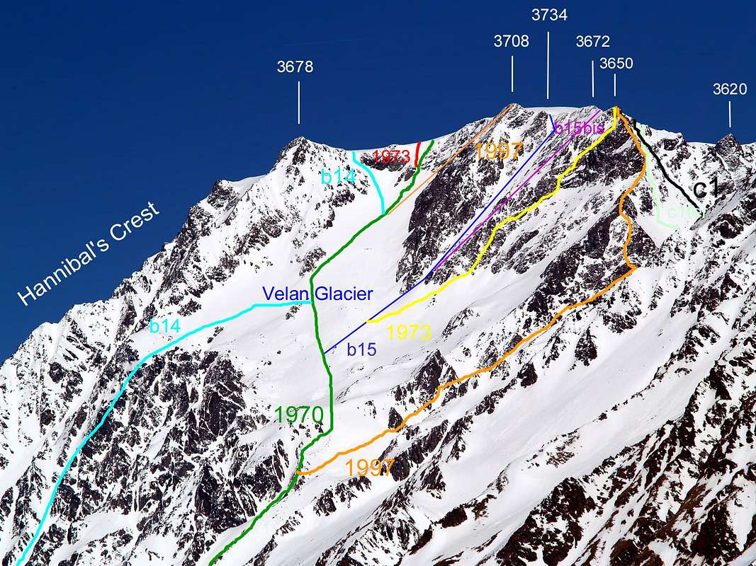
The premises must make do with the first winter ascent by the strong Pantaléon Bovet, Evanzio Blanc and Valérien Jaccod in December 28th, 1904 starting at Champillon Pastures. But these Mountaineers were of Doues, Ollomont and Valpelline Municipalities, or across the Great Sainct Bernard Valley ... Even the West Ridge with full path from the Pass of Hannibal (2.992m), thus bypassing the Aiguille de Déjeuner (3.341m), is the prerogative of the Monks of the Hospice D'Allèves and Marquis that run downhill in 1826. And the slope above the Aosta Valley Etroubles (Vallons of Menouve and Molline)? This relatively large Southwestern Wall, above the Glacier du Mont Velan and then in the Valley of the Gran San Bernardo, is addressed for the first time down by H.J. Leaf with the Guides Hans Baumann and Daniel Bich September 3th, 1872 ("Alpine Journal" VI, page 62); whilst crossing Velan down the South Side, the more rocky, through a small couloir between the altitudes 3.708 and 3.672 meters. A variation to the last of the two will be built by Agostino Ferrari and Edoardo Garrone Guide Cesare Meynet Valtournanche July 15th, 1902, in 6 hours from the Mountain Molline. The opposite or Northern had been climbed 4th September the year before by Guido Cibrario and F. Viale with Swiss Guides Omer (father, 76) Daniel Balley, which starting from the same alp passed directly also the large bedrock (about 500 meters) below the glacier. The same can also be passed to the left (North) converged on the West Ridge, just upstream of the Aig. de Déjeuner. The central sector, completely frozen, was crossed by Gino Buscaini Silvia Metzeltin October 31th, 1970 in downhill, while by Osvaldo Cardellina Renzo Botti with climb even more direct Sept. 6th, 1973, in day of Prailles with descent to a route immediately more in South than in 1902 (great landslide near the end). In more recent times, namely 27th July 1997, the first of the two has risen by only the Wall of mixed Northwest of Quote 3.708 meters, making the descent from the nearby 3.650 meters, via the South Crest to the Faceballa Pass and from this towards Quaye, starting point of the day. Over the past twenty years on this side also there were several ascents Ski-Mountaineering itinerary with to the right (East) climbing in respect of the Via 1901, laying down a steep slope made almost completely on skis with output immediately upstream portion of 3.678 meters. And the Combins? From here, crossing the St. Bernard, they appear to Pilgrims and even to Mountaineers as a distant and elusive Dream ...
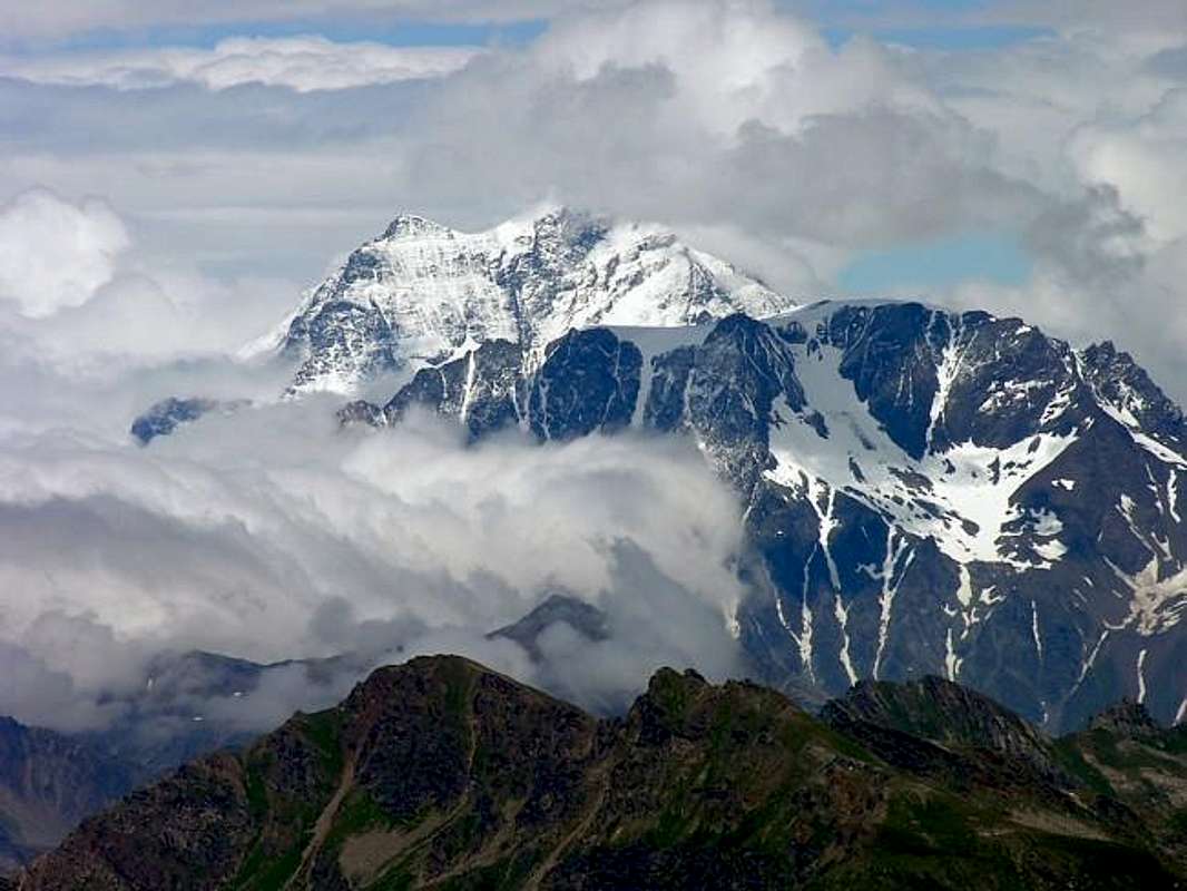
Per concludere il dopo Napoleone: il passaggio del Bonaparte lasciò una traccia indelebile nelle popolazioni locali, tanto che ancor oggi viene effettuata una "Sfilata Napoleonica" con costumi ed armamenti dell'Epoca. Insieme all'omonima "Via", alla "Francigena", al bel ed antico "Carnevale di Bosses" (rinomato per il prosciutto) costituiscono le peculiarietà di questa vallata. Imitando Annibale ed i Cartaginesi, del quale si son perse le tracce, il Condottiero passò in silenzio: le truppe da Martigny raggiunsero Liddes nella serata del 15 Maggio ed il giorno appresso raggiunsero l'Ospizio i reparti di Fanteria, seguite nei due successivi dalle artiglierie leggere e pesanti e da Napoleone col suo Stato Maggiore passando da Bourg St. Pierre. Preso da frenesia di veder la traversata delle truppe al colle, proseguì da solo con il suo garzone rischiando la vita alle rocce della Sarrière (come sarebbe cambiata la Storia!), ma Pierre Nicola Drouaz trattenne sia lui che il vecchio mulo. Alle ore 5 pomeridiane era all'Ospizio ma non c'era nessuno; il forte e freddo vento aveva "rintanato" tutti nei baraccamenti. Nello stesso si trattenne per un'ora, visitando la biblioteca, il museo, la Cappella ed all'esterno la Morgue; poi scese con la slitta arrivando a St. Rhémy ed Etroubles tra lo stupore generale. Ben diversa la discesa dell'Armata che fece un tal bordello da fare invidia ad Attila "scavando un solco" tra i villaggi e le genti che attraversava; un clamore che si ammutolì il giorno 19 dove venne "stoppata" alla Fortezza di Bard fino al 1 Giugno 1800 da parte di 400 Austro-Piemontesi, ai quali fù concesso l'onore delle armi. Ma la "Fantasia Popolare" venne colpita in modo indelebile ed il transito nella Prima Campagna d'Italia ritenuto eroico e dappertutto sventolavano bandiere tricolori (bianco, rosso e blù, ben inteso ...). Nacque il "Mito Napoleonico" e molti si avventuravano verso il Colle. Per questo motivo nacquero i "Soldats de la Neige", dei montanari locali, quasi delle Guide, che professionalmente accompagnavano Viandanti, Turisti e Pellegrini nella traversata del medesimo. Succedendo a quello che sin allora era stato fatto da Monaci e Cani. Più in là nel tempo sarebbero diventati Contrabbandieri, poiché Cacciatori l'eran già da sempre. Ma i Monaci li avevano preceduti da un bel pò di tempo: é il 31 Agosto 1779 quando il Monaco Naturalista Laurent-Joseph Murith dell'Ospizio del Gran San Bernardo insieme al Cacciatore svizzero Genoud compiono la prima ascensione assoluta del Mont Velan (3.734 m) tramite la Faccia Nordovest e la "Cresta di Annibale"; la stessa non sarà più salita fino al 1824, cioé dopo il passaggio di Napoleone. I locali si devono accontentare della prima salita invernale da parte di Pantaléon Bovet, Evanzio Blanc e Valérien Jaccod il 28 Dicembre 1904 con partenza dall'Alpe di Champillon. Ma questi erano di Doues, Ollomont e Valpelline, ovvero dall'altra parte del Grande ... Anche la Cresta Ovest integrale dal Colle di Annibale (2.992 m), quindi scavalcando l'Aiguille de Déjeuner (3341 m), é appannaggio dei Monaci dell'Ospizio D'Allèves e Marquis che la percorrono in discesa nel 1826. Ed il Versante valdostano sopra Etroubles (Valloni di Menouve e Molline)? Quest'abbastanza larga Parete Sudovest, sopra il Glacier du Mont Velan e quindi nella Valle del Gran San Bernardo, viene affrontata per la prima volta in discesa da parte di H.J. Leaf con le Guide Hans Baumann e Daniele Bich il 3 Settembre 1872 ("Alpine Journal" VI, pagina 62); durante la traversata del Velan scendono il lato Meridionale, quello più roccioso, tramite un canalone tra le quote 3.708 e 3.672 metri. Una variante all'ultima delle due sarà realizzata da Agostino Ferrari ed Edoardo Garrone con la Guida Cesare Meynet di Valtournanche il 15 Luglio 1902, in 6 ore dalla Montagna Molline. Quello opposto Settentrionale era stato salito il 4 Settembre dell'anno antecedente da Guido Cibrario e F. Viale con le Guide svizzere Omer (padre, 76 anni) e Daniel Balley, i quali partendo dalla stessa alpe superarono direttamente anche il grande basamento roccioso (circa 500 metri) sottostante il ghiacciaio. Lo stesso può essere superato anche più a sinistra (Nord) confluendo sulla Cresta Ovest, giusto a monte dell'Aiguille de Déjeuner. Il settore centrale, completamente ghiacciato, é stato percorso da Gino Buscaini e Silvia Metzeltin il 31 Ottobre 1970 in discesa, mentre da Osvaldo Cardellina e Renzo Botti con salita ancora più diretta il 6 Settembre 1973, in giornata da Prailles e discesa per una via a Sud di quella 1902 (grande frana quasi al termine). In tempi più recenti ovvero il 27 Luglio 1997, il primo dei due ha salito da solo la parete di misto Nordovest della Quota metri 3.708 metri, con discesa dalla vicina Quota 3.650 metri, tramite la Cresta Sud al Colle di Faceballa e da questo all'Alpe Quaye, punto di partenza della giornata. Negli ultimi venti anni inoltre su questo versante si son registrate diverse ascensioni di Sci-Alpinismo con un itinerario subito a destra (Est) della Via 1901, che prevede una ripida salita effettuata quasi completamente con gli sci ed uscita subito a monte della Quota 3.678 metri. I Combins? Da qui, passando il colle, appaiono come un Sogno lontano ed inafferrabile ...
Getting There
BY CAR:
- From TORINO, MILANO, etc: Motorway A5. Exit at IVREA or Quincinetto (PIEDMONT) From IVREA Town: before in West to Aosta, after in Northwest to Gignod, Etroubles, Saint-Oyen, Saint Rhémy en Bosses Municipalities. From Courmayeur Resort: before in East to Aosta, after in Northwest to Gignod, Etroubles, Saint-Oyen, Saint Rhémy en Bosses Municipalities.
- Specific Road: From Aosta Town towards the subsequent Variney Fraction (785m) immediately before the Gignod Common (988m) with Great Saint Bernard SS.27; leaving right (North) the alternative towards Allain Commune (1.251m); from this reach before Etroubles Commune (1.280m) and just after Saint-Oyen Commune (1.377m). Continue West up to the entrance of Great St. Bernard Tunnel; abandoning left the same go up in North reaching Saint Rhémy en Bosses Municipality (1.632m) now into the upper part of Grand Saint Bernard Valley and, always through the State Road, up to the Grand Saint Bernard Hill (2.469m) with the Hospice.
- From FRANCE: through the Mont Blanc Tunnel to Entrèves-crossroads to Vény/Ferret Valleys - Mountain Guides of Courmayeur - La Saxe Rock Gym - Courmayeur. By Little Saint Bernard Pass, closed since November until half May to La Thuile Valley - Pré Saint Didier - Courmayeur. It is not necessary to take Motorway A5: you can drive on SS.26, in the direction of AOSTA - IVREA - TURIN.
BY PLANE: Aeroporto "Corrado Gex" Saint Christophe (Aosta).
All its small valleys & vallons
From Aosta, Gignod, Etroubles, Saint Rhémy en Bosses towards Allein Municipalities and Grand Saint Bernard Hill Artanavaz/Buthier Streams Valleys & surroundings Gignod-Les Arpilles small Valley: from Aosta North with Main Route of Great Saint Bernard to alternative near Gignod-Lexert Commune/Fraction (1.044m); through the deviation, in asphalt, to Tercinod Dessous (1.108m), Rebiache (1.319m) Fractions. From this by farm dirt road to Arpeilles (1.419m); with unnumbered path to junction Southeast and Northeast Crests, two subsequent small saddles and Chalignes Summit.
Buthier Vallon: from Aosta with preceding road after alternative Lexert Fraction to following fork to Condémine (1.132m); through the deviation, in asphalt, to Grand Buthier (1.431m), Petit Buthier (1.441m), to fork Meriau/Mendey (1.598m; small parking). Reached the last (1.598m), continue on farm road to Roncaille (1.656m), Rombason (1.695m), Arolla (1.788m) Pastures, Refuge Chalignes near the Alp (1.936m) and La Tsa (2.225m). From this:
1) - in South to East Crest of Chaligne, with path;
2) - in West Passo Tardiva (2.410m), with path and in descent towards the Arsy Comba.
Arsy or Ars small Valley: from Mendey continue on dirt road in West to Meriau (1.603m), Praz Gallet (1.626m), Arsy (1.981m) Alps; with the same, concomitant with paths n° 3C/4, to Chaz d'Arsy Alp (2.263m), nearby three small Ars Ponds. From this:
1) - in Northwest with path to Ars Pass (2.534m), unnumbered path;
2) - in South to Mont Fallère, East Shoulder (3.043m) Northern Slopes, easy but steep with rotten-debris rocks.
![]()
Flassin small Valley: with St. Bernard Road to Etroubles (1.270m)/Saint Oyen (1.373m) Municipalities; leaving right the same go on dirt road/path n°7 to Champex (1.411m), Flassin de Meitin (1.654m), Flassin (1.700m) Pastures to Tsa de Flassin (2.258m) Alp. From this:
1) - in Southeast Fenetre Pass (2.729m), without path;
2) - in South Vertosan Pass (2.689m), unnumbered path and traces in terminal part.
3) - In South-southwest Flassin Pass (2.605m), path n° 7;
4) - in Northwest Testa Cordella(z) (2.663m), with path n° 7B. Easy traverse on ridge to Mount Flassin (2.772m).
Citrin Comba: from Saint Oyen to Saint Leonard Fraction (1.519m), leaving the Main Road to Great Saint Bernard. From this in Southwest Comba/Pont Hamlets, fork 1.464 meters; taking in South the path n° 8 to "Fonte Ferruginosa", Citrin de Meitin (2.005m) Pasture, Citrin Damon (2.312m) Alp to Citrin Hill (2.484m). In descent with path n°10 to Vertosan Vallon, Vetan Comba and Dora Baltea Stream Central Valley.
Serena Northern small Valley: from Grande Rocher (1.544m), nearby Saint Leonard, continue with Municipal Road in West to Couchepache, Sainte Anne, Mottes (1.660m) to Maytie (1.676m; no transit signal). With path n° 9, crossing in South Bosses Torrent, to Farettes (1.666m), Arp du Bois Desot (1.936m); along the vallon in Southwest to Serena Hill (2.547m). Descent with path n° 6 to Planavalle Vallon, above La Salle Common.
Créton du Midi-Tête des Faces Vallon: Arp du Bois Desot (1.936m) Pastures in Southwest to Damon (2.109m); amongst two torrents, without path but debris and moraines, to Saddle 2.557 meters, between Grand Créton/Tete des Faces. In descent, same terrain, to following and in parallel Entremont Vallon: from Mottes to parking under Saint Bernard Motorway, nearby Devies Pasture (1.723m; no transit signal) with path-Haute Route number 1 to Merdeux-Desot (1.919m), Cotes (1.930m), Moindaz (1.973m) Pastures.
1) - Going along small torrent reach a source at the beginning, under the Entremont Point (2.650m); also from fork pastures returning, with unnumbered path, in South to Potz-Ardusi Pasture (1.784m) and through grassy-debris slopes to Entremont Vallon, below Tete des Faces (2.583m). In descent same route or connection between the two.
Merdeux Comba: from Mottes to parking under Saint Bernard Motorway, nearby Devies Pasture (1.723m; no transit signal) with path-Haute Route number 1 to Merdeux-Desot (1.919m), Cotes (1.930m), and in North to fork about 1.950 meters near Moindaz (1.973m) Pastures. After, more in Northwest, to Tsa de Merdeux (2.285m) and in West Malatrà Hill (2.928m). In descent with path n° 28/Haute Route number 1 to Malatrà Vallon.
![]()
Saulié or Ceingles Vallon: from Tsa du Merdeux in North with unnumbered path, traces and path n° 12, in final part, to Ceingles Pass (2.817m), between Little Golliaz and Aiguille of Saulié. Descent with the last path to Thoules Comba, below East-southeast Face of Great Golliaz (3.237m).
Tula-Golliaz Comba: from Moindaz or Muenda Pastures:
1) - in North along the Thoules Torrent to cross with the private dirt road from Tsa de Merdeux or from Merdeux Desot at the beginning of path n° 12 to Saint Rhémy Pass (2.540m);
2) - through vallon floor, along the torrent, to ponds 2.622 meters and
3) - with terminal part of path n° 12 to Saulié Pass, or
4) - in Northwest through steep moraines to Angroniettes Pass (2.936m).
Arc-Saint Rhémy Pass Basin: from Praz de Farcoz Pasture (2.223m; small parking), nearby the SS.27 of Great Saint Bernard,
1) - in Southwest with path n° 12 to Saint Rhémy Pass;
2) - in Northwest to Fourchon Pass (2.696m), through debris, moraines and easy small rocks.
Fenêtre Vallon: from alternative 2.356 meters (small parking), nearby Montagna Baou (2.373m) and just before Great Saint Bernard Hill, in West with unnumbered path and traces
1) - Mount Fourchon (2.902m; ski-mountaineering); in Northwest with path n° 13A
2) - Fenêtre Hill (2.698m).
![]()
Great Saint Bernard Valley: from Aosta North by SS. Great Saint Bernard n° 27 (National Road), leaving Northeast the Regional Road to Valpelline, to Gignod, Etroubles, Saint Oyen, Saint Rhémy en Bosses Municipalities and Great Saint Bernard Hill (2.469m) towards the Switzerland.
Sports Routes ("Via Francigena" and "Napoleonic Route"): from Aosta Town or from Gignod Commune
1) - "Road of the Vineyards on Via Francigena" to Etroubles Commune, excursion for Hikers and Walkers;
2) - from Aosta Town "Napoleonic Route" to Great Saint Bernard Hill with descent to Switzerland, for Hikers.
3) - "Snowshoes Route" from Winter No Transit, immediately after Saint Rhémy Municipality (about 1.560 meters; parking), to Great Saint Bernard Hill, for Mountaineers with snow rackets.
Barasson Vallon:
1) - Etroubles to alternative 1.348 meters and in Northeast to Palais Dessous, Veyaz and Prailles Dessous ("Agriturisme La Granze in Tsi Inconnu"), asphalt road; or
2) - from Saint Oyen (1.373m) in East to Farm, same road. From the fork before Prailles in Westr-northwest to Eternon (1.645m) Village, through Municipal Road. From this dirt road to fork 1.715 meters (signal no transit) and in West to Essanaz or Lessanaz Pasture (1.820m); crossing Ravine Wood and Barasson Torrent to Barasson Alpages (1.868m). After along torrent and path n° 16/17 to Crétoux Alp (2.074m); from this in North and path n° 16 to
3) - Barasson Oriental Pass (2.681m).
4) - In East, path n° 17, towards the Mont Paglietta (2.320m).
Menouve or Menovy small Valley: from Prailles Dessous-Quaye (signal no) to Menouve Pastures (1.913m), with dirt road; with path n° 21 to Trecaoudette Pasture (2.133m), in North to Tsa de Menovy (2.243m) in West Tsa Nouva. Continue, path n° 21, to Southern Menovy Pass (2.758m).
Molline small Valley: from Menovy with unnumberd path to L'Arvus Alp (1.983m). Leaving left Menouve Vallon to Molline Alp (2.295m; ruines), Molline Bivouac (2.415m) near Alp, with path n° 21 in Northwest
1) - Molline Pass (2.915m), with unnumbered path-traces; in North
2) - Hannibal Pass (2.992m), between Mount Velan (3.734m), West Crest, and Testa Grisa (3.060m), through traces, debris, blocks and easy broken rocks.
Allein-Saron small Valley: from SS.27, after Gignod and before the torrent in altitude 1.083 meters, deviation to Allein Commune (1.253m); from this by dirt road to hanté and Daillon (1.417m; signals no transit). Continue to Crou, Maurier, Comba, Pied du Plan (1.722m), Baravex Dèsott, du Meitin and Damon (1.925m), Parc (2.014m) Pastures. Through Fontaines Wood with path n° 24 to Fontanin Alp (2.227m) Mount Saron (2.681m).
![]()
Campings
Remember that free camping is forbidden (except for emergency reasons, over 2.500m, from darkness until dawn).
Mountain Conditions
- Meteo: you can find all the needed informations at the official site of the Valle d'Aosta Region:
- Valle d'Aosta Meteo
Books and Maps
BOOKS:
- "Guida delle Alpi Occidentali", di Giovanni Bobba e Luigi Vaccarone C.A.I. Sezione di Torino Volume II (parte II), 25 Maggio 1896.
- "Guida dei Monti d'Italia-Alpi Pennine" (Vol. I°) di Gino Buscaini-Club Alpino Italiano/Turing Club Italiano, Luglio 1971 (in Italian).
- "80 itinerari di Escursionismo Alpinismo e Sci Alpinismo in Valle d'Aosta", di Osvaldo Cardellina, Ed. Musumeci, Giugno 1977 (in Italian); seconda Ed. Luglio 1981; terza Ed. Luglio 1984; (in French), prima Ed. Febbraio 1978; seconda Ed. Marzo 1980.
- "Guida della Valpelline" de l'Abbè Joseph-Marie Henry-Societè Editrice Valdotaine 1925 II Edition e Collana Reprint Musumeci (1986).
 |
 |
MAPS:
- Kompass "Monte Bianco Valle d'Aosta Sentieri e Rifugi" Carta turistica 1:50.000.
- L'Escursionista "Gran San Bernardo Ollomont" Ed. Rimini (carta n° 3) 1: 25.000.
- I.G.C. Istituto Geografico Centrale "Carta dei sentieri e dei rifugi" 1:25.000.
- I.G.C. Istituto Geografico Centrale "La Valpelline Ollomont, Saint Barthélemy", (carta n° 115) Map1:30.000.
- L'Escursionista "Gran San Bernardo Ollomont" Ed. Rimini ( n° 5) 1: 25.000.
Important Information
- REGIONE AUTONOMA VALLE D'AOSTA the official site.
- FONDAZIONE MONTAGNA SICURA Villa Cameron, località Villard de la Palud n° 1 Courmayeur (AO) Tel: 39 0165 897602 - Fax: 39 0165 897647.
- SOCIETA' DELLE GUIDE DELLA VALPELLINE Etroubles-Strada Nazionale, n° 13 - Tel +39 0165 78559 - Valpelline-Loc Capoluogo, n° 1 - Tel +39 0165 713502 (AO) Italia.
- A.I.NE.VA. (Associazione Interregionale Neve e Valanghe).
Useful numbers
- Protezione Civile Valdostana località Aeroporto n° 7/A Saint Christophe (Ao) Tel. 0165-238222.
- Bollettino Meteo (weather info) Tel. 0165-44113.
- Unità Operativa di Soccorso Sanitario Tel. 118.