
|
|
Area/Range |
|---|---|
|
|
46.05920°N / 8.11306°E |
|
|
Hiking, Mountaineering, Sport Climbing, Big Wall, Via Ferrata |
|
|
Spring, Summer, Fall, Winter |
|
|
11995 ft / 3656 m |
|
|
Overview
Antrona is a lateral valley of Ossola, the great area in the north east of Piedmont that from 'Lago Maggiore' ascends to the famous Simplon pass.The groove of Antrona valley, on the hidrographic right of Toce river, starts just a few kilometers at south of the city of Domodossola and ascends toward W-NW, ending below the high flanks of the peaks that divide Piedmont from the swiss region of Wallis.
The maximum elevation in the territory is 3656 meters at the summit of Pizzo Andolla, several other summits higher than three thousand meters are located all over the border line.
These higher peaks, together with the lower ones, offer the possibility of mountaineering and hiking in a savage and solitary environment.
The predominant rock is Gneiss so the shape of the mountain is the typical one of the Southern Western Alps, with very high flanks hanging over narrow valleys but without huge rock walls like those of granitic peaks.
The SE face of Loranco peak is anyhow considered the most difficult alpine rock wall of the Pennine Alps range and has an height of 650 meters.
In the group of Andolla other walls and ridges offer pleasant mountaineering/rock-climbing routes, on firm rocks, with classical difficulties (from III to IV+ of UIAA scale).
Due to the proximity of Maggiore and Orta lake at SE sudden weather changes are frequent in this valley during summer and late spring.
Solitary landscapes always attends who ventures over these fierce mountains, while the view from the summits always embrace the highest 4000s of Switzerland and the big lakes of Piedmont and Lombardy in italy.
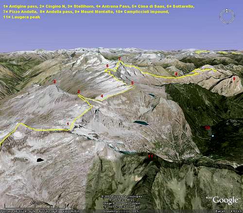
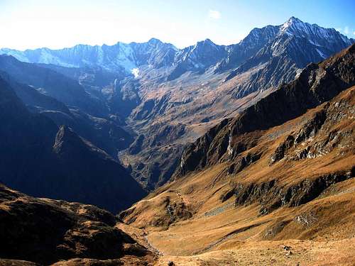 Val Loranco, the northern branch of Antrona with the higher summits of the area
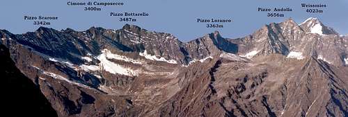 The principal summits along the border with Switzerland
Getting There
From Italy.The valley is easily reachable from Milan(and Malpensa airport) in less than two hours following the highway Milano-GravellonaToce and then the SS33 for Simplon pass.
From Turin follow the A26 and then take the highway to Gravellona toce, after Gravellona proceed on the SS33 as from Milan.
Arrived at the exit of Villadossola follow the easy mountain road (SP67) that leads to Antronapiana(1020m), the highest village of the valley.
From Switzerland.
From Brig cross Simplon pass and enter in Italy.
Follow the main road (SS33) in direction of Milan, after Domodossola take the exit of Villadossola.
Follow then the main road of the valley (SP67) till AntronaPiana, the principal village of the area.
Antrona Sub-ranges and secondary valleys
After Antrona Piana, the highest village of this area, the groove of the valley splits in two, forming Loranco valley at north and Troncone valley at south.A paved road leads to Cheggio(1500m), a small village at the beginning of Loranco valley and a parking is located near Lago dei Cavalli, 'horses lake', one of the big impounds of the valley and the main trailhead for all the routes of Loranco valley.
To get to the entrance of Troncone valley by car you can instead follow the paved road that always from Antrona Piana leads to Antrona lake, where a private road continues till the barrage of Campliccioli at 1300 meters.
This last private road is normally open to everybody, note anyhow that it is very narrow and no public autority will take responsibility for any accident over there.
Campliccioli is the starting point for the routes in Troncone valley.
The state border between Italy and Switzerland runs along the ridge that closes the valley at NW, the mostly used passes to cross from a country to another are Andolla pass(2476m) in Loranco valley, one of the principal tobacco smuggling routes of the first half of '900 and Antrona(or Saas) pass(2807m)in Troncone Valley.
Montalto group
 | This group closes Loranco valley at east going from Fornalino pass (south) to Andolla pass (north) and signing the border with Bognanco Valley, the maximum altitude is at the top of Montalto, 2705m. These mountains offer some nice hike possibilities and the top of Montalto is normally reached without tecnical difficulties from the impound of 'Lago dei Cavalli'(Lake of the Horses). |  |
Andolla Group
 | From Andolla pass to the summit of Pizzo Bottarello (Sonninghorn) this range closes Loranco valley at north signing the border line between Italy and Switzerland. The three mountains of this group are the highest of the Valley, East to West: -Pizzo Andolla (Portjengrat) 3656m. -Pizzo Loranco (Mittelruck) 3363m. -Pizzo bottarello (Sonnighorn) 3487m. They are not easy from the Italian side but the east ridge of Loranco ("Lago Maggiore" ridge) and the South ridge of Andolla are appreciated classical mountaineering routes with some good rock climbing (difficulties goes from AD+ to D, max IV+ UIAA scale) on solid rocks above the altitude of 3000 meters. The east face of Loranco is moreover the hardest alpine rock face of the Pennine Alps (from TD to ED+, VI and VII of UIAA scale) and has an height of 650 meters. |  |
Turiggia Pozzuoli group
 | the southern ridge of Loranco valley separating its groove from the one of Troncone valley. The most important mountains of this ridge are Punta Turiggia (2811m) and Cima Pozzuoli(2615m). At the beginning of the last century an huge landslide detached from Cima Pozzuoli and dropped in to Troncone valley closing the water course of Rio Troncone and creating the lake that is now called Antrona lake. The summits of this group are easy reachable from Loranco valley and they offers nice views. The trails are not well signed. |  |
'Cresta di Saas' Group
 | Cresta di Saas, Saas ridge in english, is the prosecution at SW after Pizzo Bottarello of Andolla group, its name is due to the fact that the summit ridge of these mountains divides Antrona Valley from Saastal in Switzerland. The highest peak is Cimone di Camposecco(3400m). The east side of this range falls with cliffs and steep colouirs over the cirque of Camposecco lake, the West side descends instead gently above the highlands of Furgg Valley, in the territory of Switzerland. These are rugged mountains that are rarely visited, the entire ridge cross from Cima di Saas (SW) to Pizzo Bottarello (NE) is a classical mountaineering route with incredible views towards the 4000s of Switzerland and the big Lakes in Italy. |  |
Cingino Group
 | This is the group that closes at north the long groove of Troncone Valley, going from Antrona pass(2805m) till Antigine pass(2980m). The most important summits of this group are Cingino South(3190m), Cingino N(3226m) and Stellihorn(3436m), which summit is located entirely in the Switzerland territory. These mountains are usually reached by easy mountaineering routes from Antrona pass or from Monte Moro pass in Anzasca valley. A spectacular trekking or ski-mountaineering route that crosses the entire rige from Monte Moro pass to Antrona pass is often covered in spring and summer |  |
Antigine-Laugera-San Martino group
 | From Antigine pass these ridge closes Troncone Valley at West and South. It also delimit the border between Antrona valley and Anzasca valley. The most important summits are Laugera (2995m), Pizzo San Martino(2711m) and Pizzo del Ton(2680m). The only summit frequently climbed is Pizzo San Martino, easy reachable from Campliccioli lake. This range offers nice trekking possibilities. |  |
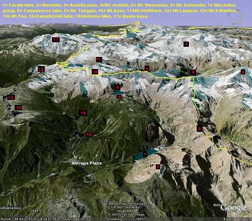
Here after the 3D maps of the Area from East and West(Google Earth).
 |  |
Huts
 | Andolla hut. The most used starting point for the normal route to Andolla peak, the trail to reach the hut start from Cheggio, a good path leads there in 2 hours. |
 | Varese hut. A very small hut located at the basis of Pizzo Loranco East ridge(2500m), normally used like starting point for the "Lago Maggiore" ridge and the east face of Pizzo Loranco, for the South ridge of Pizzo Andolla and for crossing from Loranco to Troncone valley through the Camposecco's Coronette pass (very pleasant hike with a short Via Ferrata right above Camposecco lake). from Andolla hut by a signed trail in an hour. |
 | Camposecco hut. Located in proximity of the barrage of the impound of Camposecco(2300m) and usefull for mountaineering in the Saas ridge group or for crossing to the Loranco valley through the Coronette pass. You get there from campliccioli in 2/3 hours following a steep trail very hot during summer. |
| Antigine hut. At Antigine pass(2855m), important support for mountaineering, trekking and ski-mountaineering on the western summits of Troncone valley, its acces is long and complicated from Campliccioli, It's often reached from Monte Moro pass, starting from Anzasca valley. |
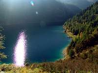
A valley with many lovely lakes
In this valley there are 4 big impounds and another lake born as a consequence of a big landslide.The big impounds surely deserve a visit, being the environment around them still very savage and solitary.
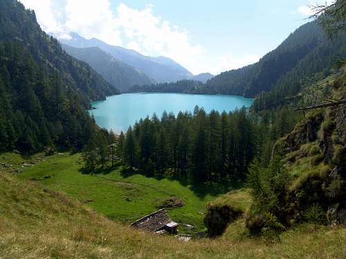 Lago dei cavalli, Lake of the horses
 | Lago dei Cavalli. This is an impound built at the beginning of the past century, it's located at the entrance of Loranco valley at an altitude of 1500 meters, adjacent to the small village of Cheggio. To get there follow the paved road from Antronapiana (12Km). |
| Lago di Antrona. At the beginning of 1900 an huge landslide ruined from cima Pozzuoli and obstructed the the flow of Rio Troncone, as a consequence of this event the water of Troncone formed Antrona lake. This lake is located at an elevation of 1050 meters. A restore and a camping are located in the proximity of this lake, reachable in a few minutes by car from Antrona Piana. |
 | Lago di Campliccioli. This is another big impound and the starting point for all the routes of Troncone valley. A private road ascends to the barrage from the Lake of Antrona, this road is normally open to everybody and you can use your car, nobody will anyhow take responsibility for eventual accident on this road that is very narrow. |
 | Lago di Camposecco. The highest impound of the valley (2300 meters), located under the east face of Saas Ridge. The cirque of Camposecco is reachable by a trail starting at the barrage of Campliccioli lake, the name Camposecco means 'Dry field' in english and is due to the aspect of the area before the building of the barrage, A dry and hot rock sprawl exposed toward south. |
 Lago di Camposecco. 2300m.
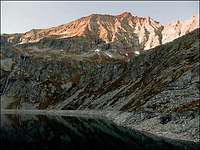 | Lago del Cingino. The second impound for elevation of the valley, at 2200 meters, closed between the south face of Saas ridge and the east flank of Cingino peaks. This lake is located in a very remote position, a pleasant trail from Campliccioli crosses all the long Troncone valley and climbs to the lake. A tunnel under Punta La rossa permits to walk quickly from this impound to the one of Camposecco without loosing altitude and permits a pleasant trekking of one day that passes by the shore of these lakes. |
External Links
The following sites are useful to find informations about the paths, the huts and the accomodations:http://www.valleantrona.com/
The official site of the valley.
http://www.comune.antronaschieranco.vb.it/
http://ossola.com/
http://www.valleantrona.com/escursioni.htm