-
 24117 Hits
-
 83.99% Score
-
 18 Votes
|
|
Mountain/Rock |
|---|---|
|
|
37.75610°N / 107.862°W |
|
|
Hiking, Mountaineering |
|
|
Summer, Fall, Winter |
|
|
13738 ft / 4187 m |
|
|
Overview and Access

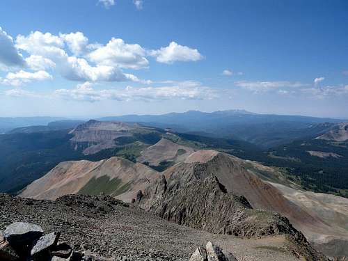
Grizzly Peak and its surrounding areas are ideal for the backcountry traveler. The peak itself can be seen from the Purgatory Ski Area (DMR) and also briefly from the first hairpin turn on Cascade Creek at the bottom of Coal Bank Pass. This Grizzly Peak is one of four such named peaks in Colorado, and it is rarely climbed. Any approach to the mountain will take considerable time and effort. Accordingly, the best experiences in this area may begin with an overnight camp and an early morning start on foot.

The area can be topographically confusing, but it is ideal for those who like to wander the backcountry and practice routefinding. The mountain straddles a remote boundary between the Animas River drainage, and the much quieter Dolores River drainage. Compounding the routefinding demands in this area are an impressive expanse of talus fields that ripple away from the mountain like a curtain. The talus fields require a great deal of effort to cross and are extremely unstable in parts. The next section describing routes to the summit will address these talus fields at length.
Cascade Divide Road
With the intent of summiting the peak, the best point of access will be from the Cascade Divide Road. From the Purgatory (DMR) ski area on Hwy 550, drive through the main gate to the resort and keep making right turns until you begin traveling on Hermosa Park Road. This is a maintained gravel road, although it can have a lot of washboard. Follow Hermosa Park Road, bearing to the right at intersections, until you make the final right turn onto the Cascade Divide Road. Once on Cascade Divide Road, travel 11 miles to where it ends at a spur trail that provides access to the Colorado Trail. This road is rough at first and it eventually becomes a high clearance 4x4. Cascade Divide Road seems to go on forever, and it will take you more than one hour to reach its end from the resort entrance on Hwy 550.
Bolam Pass
To explore the wonderful backcountry area west of Grizzly Peak, start on Hermosa Park Road as described in the previous paragraph. Instead of making the final right turn for Cascade Divide Road, continue into Hermosa Park and then follow the signs for Bolam Pass. This road is maintained dirt/gravel until the top of the pass, but it is a long drive. If desired, continue west from the summit of Bolam Pass to reach Hwy 145 near the town of Rico. This last section west from Bolam Pass is a rough 4x4 high clearance road.
Talus Topography: Experienced Scrambling and Backcountry Routefinding
There are three prominent ridgelines that extend south from Grizzly Peak. Study them carefully on a 1:24,000 scale topo map before you enter this area. When you reach the end of Cascade Divide Trail, the Sliderock Ridge and Graysill Mountain will have been on your left (west.) Once you leave your vehicle, follow the short unmarked spur trail over to the Colorado Trail (which is marked.) Turn right on the Colorado Trail. When you cross the larger of two streams a short time later, from the stream crossing leave the trail and walk a very short distance up to the base of a large talus ridge (east.) DO NOT BE TEMPTED TO GAIN THE FIRST TALUS RIDGE ON THE EAST. The material is simply awful.


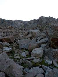
Instead, begin to contour north along the bottom of this rotten talus ridge, following the point where it meets the tundra to stay on solid ground. You will hike north into a high basin where the "rotten talus ridge" (east) and the Sliderock Ridge (west) join in front of you at a defined saddle. This first basin is a fun area. The central talus fields are very stable and contain many unusual features. The topography is deceptive, however, because it is easy to lose track of how these two ridges are joining ahead of you. It is also easy to believe that you are close to the peak. You are not.
There are 2 possible routes.
1.) Gain the saddle immediately north of you, and continue to contour around the west side of the mountain. This will take you to a basin directly below Grizzly Peak (described below.)
2.) Alternatively from high in this first basin, it is finally possible to access the east ridge on stable material. From a point high in the basin, but still south of the north saddle just described, look east and you will see a blackish area leading to a saddle on the east ridge. Gain this east saddle, and then from this point it is now possible to do a ridge traverse north to Grizzly Peak. (I have not been able to fully complete this ridge traverse, but where I have been on it I have encountered fun class 3 scrambles. Beware some class 4 pinch points are possible in this kind of country. It would be nice for a fellow SP member to add a route description here.)
Continuing from the north saddle.
It's a quick traverse across the first talus expanse to the north saddle. Note that the Sliderock Ridge has joined from the west, and you have now crossed into the Dolores River watershed. The main ridge to Grizzly peak now continues north and on your right. But from this point, DO NOT GAIN THE ROTTEN TALUS RIDGE TO YOUR RIGHT.
From the north saddle, gently DESCEND northwest through some "talus pockets." Your goal is to avoid the "reddish talus ridge" that will come up shortly. STAY LOW and the rock will be better. On your descent, gradually swing due north and level out a bit to contour the mountain. As you continue north, you will find the prominent reddish talus ridge that extends in a westerly orientation, and which rises as an obstruction amid this confusing mass. It has rust colored patches and streaks in it, especially at higher elevations. Contour around this ridge, either holding or losing some elevation to STAY BELOW THE RED MATERIAL. It is no fun losing elevation, but there is no shortcut to be had by attempting to move upward. As a rule of thumb, move around and below this mess, and stay on grey colored talus.
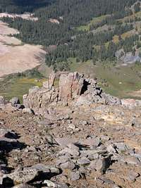
Once you come around the "reddish talus ridge," head toward the peak in a northeasterly direction. From here you can start to regain some of your elevation. You might even find some unusual "trail features" to follow, which are actually compression folds that result from the moving talus mountain. Once you are squarely on the north side of the reddish talus ridge, either descend or contour across another small talus gully to reach an open tundra basin below Grizzly Peak.
When you reach the tundra below Grizzly Peak.
Stop and take a mental note of your route back around the reddish talus ridge. The route back to the north saddle may not be very intuitive on your return trip. Now turn around and look at an angle up the mountain. Cross the tundra in a northerly direction, staying high and close to the boulders and rock walls below Grizzly Peak. The very secret entrance is close, but you will need a sharp eye to find it ;)
As you move north and gain elevation across the tundra, you will see a first gulley with some class 4 pitches. It may be better described as a crevice. This is one possible climbing route, but it becomes more difficult up high than it looks from here below.
Continue past the first crevice and study the mountain carefully. You will find a notch in the mountain wall, way up high and above a field of large strewn boulders. Now head due east and ascend directly into this notch. It turns into a couloir with somewhat lose material.
The couloir opens up quickly, and you will be inclined to continue straight or even slightly to the left. Do not do this, unless you want to get on class 4 material and eventually a verticle pitch. This is a classic example of where a mountain "tricks your eye" because from the entrance, it is hard to tell that the gulley has opened up into a small amphitheater. When you inevitably stop in the gulley to wonder which route to take next, look right. Leave the couloir by ascending at an angle TO YOUR RIGHT. There is loose scree but no exposure. Tread lightly and be careful not to induce scarring and erosion. Heading in this direction, you quickly gain a diminutive ridge that forms the right edge of the small amphitheater.
Once on the ridge, adjust your route to the left and head east. Continue up this ridge, watching the impressive features in the gulley drop away below you. Stay on this ridge, and you will eventually scramble through some solid boulders and a defined notch. Once past this notch, turn around for the view. First study your notch because this is your mile post for re-entry into the gulley. But forgive yourself if you are distracted by a view of the western San Juans that very few people have the patience to find.
From here, this cantankerous and hidden mountain turns into cheesecake. You may feel some disbelief as you complete the last few hundred feet in a northeasterly direction to the summit :) From the summit you have a spectacular view that includes Mount Sneffels, Uncompahgre Peak, the Needle Mountains, the La Plata Mountains, and the San Miguels. If so desired study the possible ridge traverse along Grizzly's "east ridge," which is actually now extending to your south. If you choose this option, remember to bail out at the blackish saddle once you find the "first basin" from up high. The final stretches of the east ridge that go south past the blackish saddle are nothing but rotten talus.
Extended Backcountry Travel: Bolam Pass and West Sliderock Ridge
This area is a classic backcountry experience, reminiscent of an "older Colorado." It winds through patches of alpine forest, wet meadows, and a loose network of hunter's pack trails. It is far easier than the talus routes described above, but it will take much more time to complete.At a point approximately 1 mile east from the summit of Bolam Pass, there is a high clearance 4x4 road that leaves the maintained road as a short spur heading north. This road provides access to the Colorado Trail as it comes down the west flank of Sliderock Ridge. Either 4x4 up this road, or park on the main road and walk to the intersection with the Colorado Trail.
Take the Colorado Trail east until you enter a wet meadow on the west flank of Sliderock Ridge. Approach the ridge, but save some distance on your route by angling northeast across the meadow. Just after you reach the end of the first meadow, you will have to contour and gain a higher trending ridge to the north, in order to avoid a small intervening basin. Otherwise this route is straightforward: just follow talus/forest boundary for approximately 4 miles until you swing east into the tundra basin on Grizzly Peak's west side. Have fun finding and following the loose network of pack trails. Once inside the tundra basin on Grizzly Peak's west side, pick up the route to the summit that is described in the previous section.