
-
 16930 Hits
-
 94.63% Score
-
 48 Votes
|
|
Area/Range |
|---|---|
|
|
46.35854°N / 13.19149°E |
|
|
Hiking, Mountaineering, Trad Climbing, Sport Climbing, Bouldering, Scrambling, Skiing |
|
|
Spring, Summer, Fall, Winter |
|
|
6424 ft / 1958 m |
|
|
Overview
Introduction
Currently, on SummitPost, Julian Alps are divided in 8 subgroups. The Kanin group (Monte Canin) includes also all the fore-hills down towards the South, where Julian Alps lower in the Po river plane. But these fore-Alps are very different than Kanin mountains. The area is very broad, nice for hiking, skiing and also climbing, so it deserves to be separated from the higher regions of Julian Alps. Also Italians call these mountains Prealpi Giulie and the natural parc, established in 1996 has the same name. Later, a few words will be also said about the dilemmas of separating Alps from Dinarides.
The character
Even if called Prealps, these mountains are far from being all humble and hilly. Some of them are as the other Julian Alps steep, rocky and wild. The other characteristic of these mountains is, that they are formed in long ranges, stretching tens of kilometers, usually in the west-east direction. As they are lower than the central regions, they are covered also with dense vegetation which doesn't diminish the impact of wilderness they do on the observer. The southern part is of course more hilly, populated by people, who live there since ancient times. Especially fruitful is the SW border of the group, where on the edge of Po river plane many beautigul towns are flourishing - Venzone, Gemona di Friuli, Artegna, Tarcento, Cividale/Čedad, Cormons/Krmin and of course the both two big cities of Udine/Videm and Gorizia/Gorica. These towns and others are all worth visiting and sightseeing.
The people
The area is inhabitated with Italians, with Furlani and with Slovenes. It is perhaps less known that Furlani people are speaking their own language, which differs considerably from the official Italian language. In many places tables with information are written in both languages, since joining the European Union, the same is more and more true also with places where Slovenian people live on the Italian territory. A special linguistic and cultural case is Val Resia / Rezija. The valley lieas on Italian territory but has been for centuries inhabited by Slavic people. They are speaking a very distinct, archaic dialect, much different from other Slovenian dialcets (some even claim their Russian origin).
Interactive map-guidebook
| See full screen |
Explore the interactive map on the left - it contains much more information than this whole page and its subpages. Mountains, routes, trail heads and landmarks are described, illustrated also by many pictures. Marked trails are drawn red, non-marked trails and pathles routes are marked brown. Where I was certain, the routes are graded by the SAC Hiking Scale. Lower areas are mostly not described on the map. There are many tourist trails, non-marked paths which locals are using and close to many hills on the south mountain roads are reaching. They are drawn on the basic map. Different symbols are used for official mountain huts and permanently open bivouacs on one side and shepherds and hunters huts on the other side. The latter are usually closed and can't be used by hikers. Alaso only some tourist attractions are drawn on the map. Especially there are many in the area of low hills and Furlania plane - on the south. |
Borders
There seem to be two dilemma regarding the bordering of Julian Prealps:
The first one is bordering them the from Kanin group. My recommendation is to make a border in Val Resia and Val Uccea / Učja. This way the long ridge of Skutnik / Monte Guarda would still remain in the Kanin group. Once done so, the eastern border is clearly formed by the valley of river Soča, separating these mountains from the Krn group and from the Northwestern Dinarides and the western border are the rivers Fella/Bela and Tagliamento/Tilment, septarating these mountains from Carnic Alps. The southern border is of course the Po river plane.
The second dilemma is more difficult. That's the question how to delimit the Julian Prealps and the Dinarides, which are reaching from the SE as high as to Tolmin town. But geologically speaking the Idria Fault, one of the most important tectonic discontinuations, is on the NW not ending in Tolmin. It runs in the same direction further up at least to the town of Kobarid. Also with the respect of rocks nature, we could say with high certainty that the ridge of Sabotin is belonging to the Dinarides. That would mean that a part of Dinarides is also on the Italian territory. For the sake of simplicity and to comply with the Italian geographical nomenclature, we shall stick to the border of Julian Prealps on the river of Soča.
Structuring Julian Prealps
Monte Plauris - Musi range
On the NW, Julian Pre-Alps are the highest. They rise steeply from the banks of rivers Fella and Tagliamento, then they stretch towards the East with a series of sharp and wild peaks. The northern borders are Resia and Uccea/Učja creeks, the southern borders are Val Venzonassa and Torre valley.
- Monte Plauris / Lopič, 1958 m. A sharp peak with long, marked approaches. Very nice panorama.
- Monte Lavara / Javor, 1906 m. Once rarely, today a bit more often visited summit, close to Casera Confin. A weak marked path.
- Monte Cadin, 1818 m. Marked path (No. 740 and 703) crosses the summit from Torre valley to Resia.
- Musi / Muzci, 1869 m. A very sharp and wild mountain range, almost impossible to be crossed. Four marked paths ascend the ridge: 1 - from Sella Carnizza on point 1866, 2 - from Torre valley on point 1866, 3 - from S. Anna di Carnizza, below Sella Carnizza to M. Zaiavor, 1815 and 4 - from Passo Tannamea to M. Zaiavor, 1815.
- Zaiavor/Zajavor, 1830 m. A still steep, but already quite grassy and easily reachable eastern end of the chain.
 M. Plauris / Lopič M. Plauris / Lopič |
 M. Lavara / Javor M. Lavara / Javor |
 Monte Musi / Muzci Monte Musi / Muzci |
 On Zaiavor/Zajavor On Zaiavor/Zajavor |
Monte Chiampon group
It rises south of Plauris-Musi range, so it's northern border is Val Venzonassa. It's eastern border is the valley of Torre/Ter river. On the northern part this group consists of a long and, despite its low altitude, still a wild ridge of Monte Chiampon / Veliki Karman. Just south of the highest summit there's a nice, panoramic balcony of Monte Cuarnan / Mali Karman. The rest towards the south are only much lower hills.
- Monte Chiampon / Veliki Karman, 1709 m. A steep and still wild ridge summit. A medium hard marked path from the south, from Malga Cuarnan, 1075 m and over Sella Foredor (pass). 2 h. Another marked path from the north, from Val Venzonassa. The ridge towards the East has many summits of quite equal heigth, half of them are connected by a marked path.
- Monte Cuarnan / Mali Karman, 1372 m. A nice panoramic balcony over the Po river plane with a church on it. Many marked paths from all sides, the shortest one from Malga Cuarnan, 1075 m and over Sella Foredor, 1089 m. 45 min.
- Cuel di Lanis / Lanež, 1629 m. A grassy pyramid in the E part of the range. Its S slopes are still very steep and precipituous.
- Monte Postoucicco / Postovčič, 1611 m. The last high summit in the eastern part of the range. Ascents from the S and the N, nice panorama.
 Monte Chiampon Monte Chiampon |
 M. Chiampon ridge M. Chiampon ridge |
 The view from Cuel di Lanis / Lanež towards the W The view from Cuel di Lanis / Lanež towards the W |
 On M. Postoucicco / Postovčič On M. Postoucicco / Postovčič |
Kobariški Stol - Gran Monte range
For more details, see the existing SummitPost page of Kobariški Stol!
This range is stretching in the west-east direction south of Uccea/Učja creek and south of the upper part of Torre/Ter river. It is still sharp and rocky on many places, but here Julian Pre-Alps are already losing their wilderness. Towards the South it is lowering with many side ridges, which are less important in the mountaineering sense, hosting many nice Friulian villages. Great area for biking!
 Kobariški Stol Kobariški Stol |
 On Stol On Stol |
 On Gran Monte On Gran Monte |
Hills west of Natisone/Nadiza river
North of Cividale/Čedad there's a hilly area where only a few hills are more important for hiking. This is also a nice biking area. Still the altitude difference towards the river bed of Natisone/Nadiža is more than 1000 meters.
- Monte Iauar / Javor, 1005 m. A grassy summit offering some panorama.
 Namlen panorama Namlen panorama |
- Monte Joanaz / Ivanac, 1167 m. A grassy summit offering nice panorama. Could be also an easy ski tour and bike tour.
 On Ivanac On Ivanac |
- Monte Vogu, 1124 m.
- Mija / Monte Mia, 1237 m. An interesting, but not very panoramic (woods) mountain which is reached by two marked paths through Predol gorge, or from the north (in 20 minutes), where forrest roads reach almost its top. Above Natisone/Nadiža river there are some points where arheologic findings were discovered.
 Predol gorge Predol gorge |
 Julian Alps from Mija Julian Alps from Mija |
 Matajur from Mija Matajur from Mija |
Matajur and Kolovrat
Casting in literature, Matajur is a true symbol of Slovenian people, living beyond the present state border. It's a broad, quite powerful mountain, offering a lot to a mountaineering soul: hikes from all sides (also of 1200 m of altitude difference), nice ski tours, mountain biking and more... As on its southern slopes the road reaches 1320 m, there's also a hut there: Rif. Pelizzo. A road pass above Livek village separates Matajur from the long and panoramic Kolovrat ridge.
- Matajur/Mataiur, 1641 m. Fine hikes, great panorana, nice ski tours. Also mountain biking possible.
 Matajur Matajur |
 Matajur panorama Matajur panorama |
 On Matajur SW ridge On Matajur SW ridge |
Also Kolovrat ridge is very special. Its panoramic road offers some of the most spectacular views in Julian Alps. Finding yourself there early in the morning or late in the afternoon, any time of the year, can be an unforgettable experience. By the grassy ridge also nice hiking trails go and you can visit many posts from the World War I which are arranged for tourist visit. Kolovrat is famous by a 25 hours break through in 1917, in which Erwin Rommel showed his war talent, performing one of the first "Blitzkriegs".
- Kuk / Monte Cucco, 1242 m. A panoramic, grassy summit on the western part of Kolovrat ridge. Over the whole Kolovrat a mountain road goes, offering nice, panoramic biking.
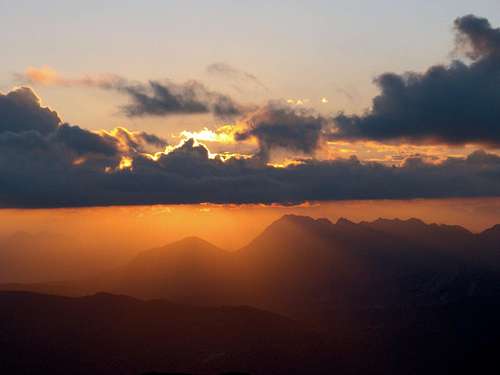
 Kolovrat sunrise Kolovrat sunrise |
 On Kolovrat On Kolovrat |
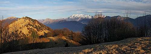
 Kanin from Kolovrat Kanin from Kolovrat |
Korada
South of Solarje pass a long, predominantly grassy ridge begins, which is stretching in a NE-SW direction. It is all on the Slovenian side, as the border between Italy and Slovenia here goes by on its west side flowing Idrija/Iudrio river. Also atop this long ridge a decent road goes. So, you can combine in a biking tour the neighbouring Korada and Kolovrat ridges.
- Korada, 812 m. An open, grassy hill. Nice biking.
 On Korada On Korada |
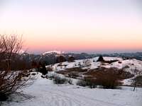
 Korada summit Korada summit |
 Sunset Sunset |
Sabotin and Brda
The last outpost of Julian Alps towards the South is the rocky, limestone Sabotin. Even if it is only 609 meters high, it offers some nice hikes from all sides and also a biking tour. The summit is very known from the World War I, when there were severe fightings. Otherwise, the frontline was running along Soca river, which forms here a true canyon. Still today you can see many rests from the war, some are arranged also for tourists visit. West of Sabotin there's a special area, which is different than the rest of Julian Pre-Alps. This is the hilly area of Goriska Brda. Very fruitful, landscape, made of flysh, reminds on the famous Toscana. All wineyards, orchards, nice villages on hills!
- Sabotin, 609 m. Nice hikes, mountin biking, nice panorama. Rests from the World War I.
 Soca from Sabotin Soca from Sabotin |
 Goriska Brda Goriska Brda |
Rivers Of Julian Pre-Alps
Soča
The most beautiful river of Julian Alps forms in its middle part the eastern border of our Pre-Alps group.
 Soča Soča |
 Soča Soča |
 Soča Soča |
Nadiža
Nadiža river is sunny, warm and still very clear. Its sources are below Stol and Gran Monte, then it flows as a beautiful creek towards the south. Near Logje it turns eastwards and seemingly flows towards Soča river, but just before Kobarid it suddenly decides to turn southwards again carves a deep canyon between Mija and Matajur and finally gets out of Julian Alps near Čedad/Cividale.
While today's main road follows the river from Kobarid to Čedad/Cividale, in the past also paths along its upper flow towards the west were much used. Today still a romantic witness of those times stands - the 'Napoleon bridge' below Logje village.
Here are some attractions of this beautiful river and its valley:
- Landarska jama / La grotta di san Giovanni d'Antro. High above the river, near Ponteacco, there's a cave with a nice church, arranged for tourist visit. It was built by early Christians and later modified by Langobard people. The cave behind the church was already used by stone age men.
- Napoleonov most / Il ponte di Napoleone. The bridge has its name by Napoleon Bonaparte, whose army was supposed to cross it. In this form it was built in the beginning of 18th century, but it is very likely that an old bridge existed there even far before. Its romantic arc reminds us on old paths, leading from Kobarid towards the west.
- Nadiža/Natisone ponds. Near Kred village and further towards the west the river has some nice places, which are used for summer swimming.
- The upper Nadiža canyon. West of Logje village the river enters a nice canyon, which can be passed, if water is not very high. All around are nice, picturesque places for swimming.
 S. Giovanni d'Antro S. Giovanni d'Antro |
 'Napoleon' bridge 'Napoleon' bridge |
 In Nadiža canyon In Nadiža canyon |
 Nadiža Nadiža |

|
Torre/Ter
This is the central river of Julian Pre-Alps. Its sources are below the wild Musi/Muzci range, then it flows towards the south. The river also has a characteristic blue colour.
Tagliamento/Tilment
The river forms the western boundary of Julian Pre-Alps.
Creeks
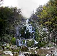
On smaller creeks there are some nice waterfalls, worth of visiting. Sušec, on the northern slopes of Stol, is a popular canyoneering goal. Bončič, below Gran Monte, can be also reached by a marked path.
 Sušec Sušec |
 Učja canyon Učja canyon |
 Bončič Bončič |
Getting There
Julian Pre-Alps can best be reached from the West by Italian highways (Udine - Tarvisio) or from the East through the valley of river Soča.
The following roads/passes are cutting the area:
- The road in Resia valley and over Sella Carnizza into Uccea/Učja valley.
- The road through Torre/Ter valley and over Passo Tannamea / Tam na Meji into Uccea/Učja valley.
- The road through Natisone/Nadiža valley to Kobarid (in Soča river valley).
In addition to these there are many local and mountain roads, connecting villages in the southern area and running over some passes and along mountain ridges. Some were already mentioned.
On the southern side of the group there are many nice towns very worth visiting and sightseeing. Most of them have a history from the Ancient Roman times, some even a longer one. By the western side once an important Via Iulia Augusta ran. Along that Ancient Roman road are today's towns like Gemona/Gumin, Venzone/Venčon and others. They were end of 20th centurs heavilly destructed by an earthquake, but today they are well restored. In the south-eastern part there is Cividale/Čedad. Founded as Forum Iulii, the town was taken over by Langobardic tribe and was long time their capital. Many archeologic remains from that time are preserved.
A good mountain map: Tabacco: Prealpi Giulie - Valli del Torre, 1:25000.
 Gemona di Friuli Gemona di Friuli |
 Cevedale/Čedad Cevedale/Čedad |
 Kobarid Kobarid |
Red Tape
In 1996 the Julian Prealps Nature Parc was established. Its headquarters are in Prati do Resia. For more details see the its official web page at: http://www.parcoprealpigiulie.org/.
 Nadiža river Nadiža river |
 By Nadiža By Nadiža |
Huts And Camping
In the whole area there are no official huts of mountaineering organizations. But you can sleep and eat in some private huts and with shephards on mountain pastures. Camping is officially forbidden, except in high regions for emergency reasons. But some areas are so remote that it is very unlikely that you would be chased if setting up a tent over a night.