
-
 26586 Hits
-
 92.32% Score
-
 38 Votes
|
|
Area/Range |
|---|---|
|
|
46.48268°N / 13.38270°E |
|
|
9036 ft / 2754 m |
|
|
Overview
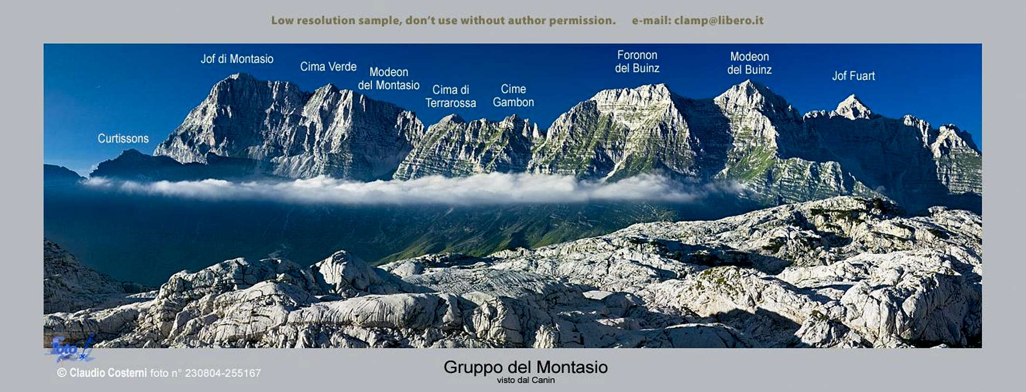
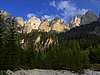
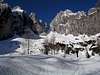
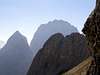
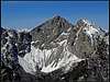
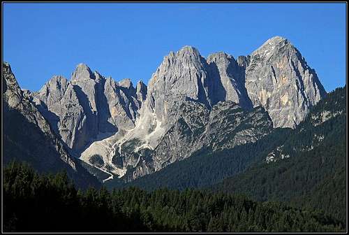
claudioNC - Montaž chain from the south
What's new on this page?
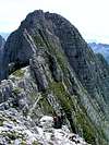
 haubi - Iôf del Montasio
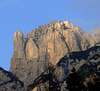
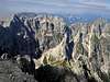
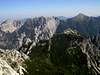
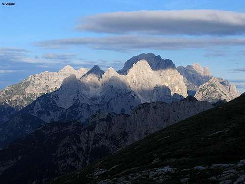
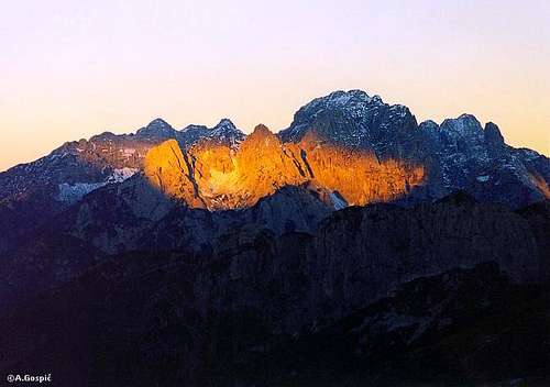 Velebit - Jôf Fuart group from the east
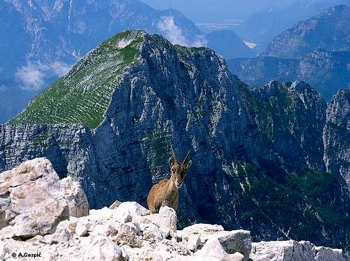
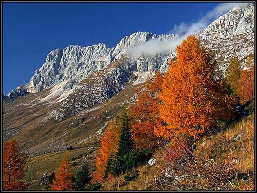 On the southern side - Altipiano del Montasio
- June 25th, 2014 - A major redesign.
- 2005-2007: Links to newly created pages inserted.
- November 17th, 2004 - Initial set up of the page.
Languages & Terminology
These mountains are rising very close to the point of Europe, where German, Roman and Slavic language groups are coming together. Also history was sweeping in its course people, coming and leaving or staying and being mixed. Centuries ago in the neighbouring valleys mostly Furlani and Slovenian people lived. With Austro-Hungarian empire ruling the territory, many German speaking people settled, especially in towns. And Italians settled there as well. Due to an agreement between Mussolini and Hitler, during the World War II German people left the area and Italian people came in, so they are now the majority. Names of mountains in Jôf Fuart - Jôf del Montasio can be found in four languages: Furlani, Slovenian, Italian and German. When first mentioned, I will write them in more languages, later only in Italian, due to the official state on which territory the group lies.
The Group Presented
The group is named here after two giants of Julian Alps and the most prominent mountains of this group: Jôf Fuart / Viš / Wishberg, 2666 m, and Jôf del Montasio / Montaž / Poliški špik, 2754 m. This is one of the most beautiful groups of Julian Alps. On a relative small territory a group of wonderful summits stands, having almost all the superlatives, which are in the rest of Julian Alps found only on separate places. Mountains are rising very high above valleys and vertical lines are predominant. Many of the mountains are almost artistically shaped.
There are remote regions, where hardly any mountaineer's foot steps, some lower summits in the western part probably wait for human visits for many years. So these mountains also have, what we in Slovenia call a 'Trenta feeling' - you find yourself on a steep, grassy and rocky slope or airy ridge, you can't proceed safely any more, it's not for belaying, it's not for living, nor for dying. This was the arena for the mountaineering legends from 150 years ago, like the wild Osvaldo Pesamosca and others. Even now life there is hardly any different than in those times. The incredible beauty stays the same, the poverty of rare people, perseverating in valleys - the same, legends - the same.
What is perhaps missing in these mountains and other Julian Alps have, is the broad, dreamy landscape of Komna and Triglav lakes, and, as the famous Julius Kugy said - Triglav. In last years of his life he was living here, in Valbruna / Ovčja ves, and when asked, which part of Julian Alps he preferred his famous answer was, that, yes, the western part could be greater - if in the eastern part there were no Triglav. And Triglav is not only a mountain, it's a whole kingdom.
Geographically the group is bound with Fella/Bela valley on the west and north, Raccolana/Reklanica valley on the south and Rio del Lago / Jezerska dolina on the east. It consists of two major mountain chains, the stronger southern chain and the weaker northern one (Malborghetto Chain).
Starting from the east, we have first on the north two stand-alone mountains: Monte Re / Kraljevska špica with its mines above Cave del Predil / Rabelj and Cima del Cacciatore / Kamniti Lovec, a perfect panoramic summit. South-east of these the Jôf Fuart group stands. This is a true forrest of sharp, high peaks, separated by narrow notches and wild ravines, leading towards them. A true eldorado for climbers, seeking difficulties of any range. Jôf Fuart area is also very suitable for the ordinary mountaineering. There are many mountain huts and bivouacs, and a dense network of marked paths is connecting them and reaching also many summits. Details have to be left for the distinct summit pages, here's only a few more general characteristics. From Cima del Cacciatore towards the SW a wild chain of Cime delle Rondini / Prednje Lastovice stretches - no marked paths to summits. Another long chain is coming to the centre of the group from the E - again marked paths go mainly over saddles and not on summits. The third chain is coming from the SE - its highest peak Cima Alta di Riobianco / Visoka Bela špica is one of the hardest summits in the group to reach. Just east of Jôf Fuart a small subgroup stands, consisting of Cima di Riofreddo / Divja Koza / Kaltwasser Gamsmutter, Innominata and Madri dei Camosci / Gamsova Mati / Hohe Gamsmutter. A nice ferrata is traversing below them, but summits can be reached only by climbing. Jôf Fuart, Monte Nabois Grande / Veliki Nabojs and Cime Castrein / Kostrunove špice / Kastreinspitzen can be reached by marked routes.
The long crest of Jôf del Montasio has a much different character. A long wall goes from the SE towards the NW and the altitudes of summits don't vary much. Distinct summits are not so important as the whole structure. Except Jôf del Montasio itself, of course. One of the most beautiful mountains in Julian Alps! From Jôf del Montasio's summit the main crest goes first towards the SW and then all the time towards west. In its mid part, there's the third 'most important' summit of the whole group: Monte Cimone / Strma peč. And more towards the west it seems like a 'complete unknown'. Only one difficult marked path, crossing broad slopes, no famous peaks, but a broad, wild unknown area. Any information of these summits will be highly appreciated! The northern chain is itself lower and less impressive, but it offers great views on the main group. All its main summits can be reached by marked routes. Ascents are not hard, only the crossing of the whole chain could be tricky on some rocky, exposed places.
Geology
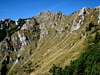
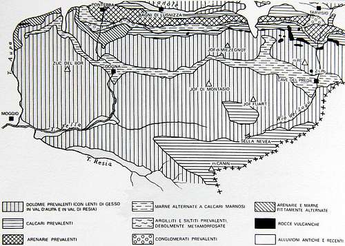 Lithology of Western Julian Alps
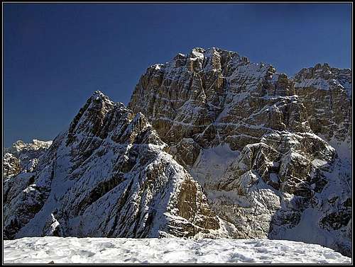 Horizontal strata of dachstein limestone, lying on dolomia principale - Nabois and Jôf Fuart
Jôf Fuart - Jôf del Montasio Group is interesting also due to its geological composition. The big majority of main mountains is made of triassic dolomia principale - at least their basements. That is why vertical lines are predominating and that is why they look so bold and picturesque. But the upper part of the main mountain streak is made of a bit younger (also triassic) dachstein limestone. Climbing up by Findenegg couloir you will for example notice characteristic, more distinct horizontal strata and also the rock is more prone to weathering. These characteristics can be noticed on all the summits of the crest from Jôf del Montasio towards the SE as well.
The northern streak of mountains, Catena del Malborghetto, has however a completely different origin and a much more complex geological structure. South of the geological fault of Val Canale the first hills have a very diverse origin - from various paleozoic epochs. That is why near Bagni di Lusnizza / Lužnice, we can find sulphurous sources. The main summits of Catena del Malborghetto are made of schlern dolomite, which is older and much more friable than main dolomite. All the summits from Monte Schenone / Lipnik to Iof di Miezegnot / Poldanašnja špica / Mittagskofel are so made of sedimentary rocks which are some 230 million years old, while the mountains in the main streak of Jôf Fuart - Jôf del Montasio are made of sedimentary rocks which are some 200-216 million years old. From schlern dolomite also Cima del Cacciatore, Monte Re and some mountains further towards the east, on the northern edge of East Julian Alps are made. Very diverse is also the surroundings of Raibl town. There traces of vulcanic activity can be found and also sediment rocks from the epoch just before dolomia principale was created. Those rocks are even named by the town: Raibl geological structure.
Finally, it is worth mentioning also that the nice landscape of the southern terrace (Altipiani del Montasio) was made by glaciers, carving those slopes. Also the deep valleys around Jôf del Montasio were significantly carved by big glaciers. Remember - in times of biggest glaciation the whole area was covered by up to 1500 m thick glaciers, so that only the highest summits were peeking out. But, interestingly, still some 500.000 years ago all waters from the big glacial basin between Viš-Montaž group on one side and Monte Kanin on the other side was drained towards the E and NE, towards today's Tarvisio basin. Only later watershed was established on Sella Nevea, so today half of waters are being drained towards the west, via Raccolana valley.
- Source (in Italian): Carulli, G.B.: La storia geologica delle Giulie (removed from the web).
- Source (in Italian): Carulli, G.B.: La storia geologica delle Giulie (removed from the web).
Subgroups & Summits
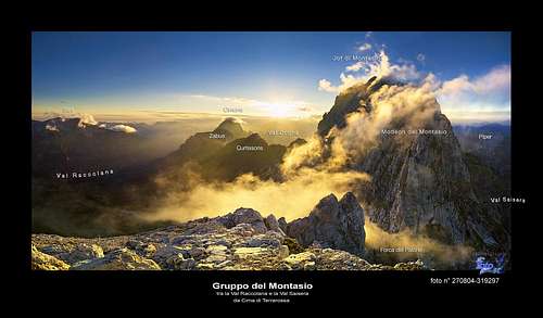
Below is the new map-guidebook, presenting much more information than the rest of the page. Explore it! (Malborghetto chain is not included - I must first translate it from Slovenian language. See full screen
Iôf Fuart Subgroup

|
Monte Re / Kraljeva spica, 1912 m. Marked path. |  |
Cima del Cacciatore / Kamniti Lovec / Steinerne Jaeger, 2071 m. Marked paths. Ski tour. Great panorama. |
 |
Cime delle Rondini / Prednje Lastovice, 1845 m, 1905 m, 1919 m, 1954 m, 1877 m. Rugged, hardly reachable summits south of Cima del Cacciatore / Kamniti Lovec | 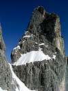 |
Cime Vergini / Zadnje Lastovice, 2000 m, 2044 m, 2150 m. Hardly reachable, tower mountains north of Cima di Riofreddo / Divja Koza. |
 |
Cime delle Cenge / Visoka polica, 2002 m. Rarely ascended mountain above Valle di Riofreddo. Marked path till the notch, 1820 m, then easy climb (marked), UIAA II/I. Nice climbs in the south wall. | 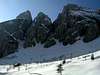 |
Vetta Bella / Lepa Glava, 2049 m. Nice panoramic mountain between Valle di Riofreddo and Riobianco valley. Marked routes (but not just easy) from both valleys. |
 |
Cima del Vallone / Krniška špica, 2368 m. Not marked, easy normal ascent (I.-II.). Wonderful classic climb in the north wall. | 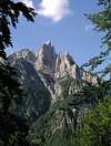 |
Cima Alta di Riobianco / Visoka Bela špica, 2257 m. One of the hardest reachable summits in the group. Medium hard climb as normal ascent (III-/II). Wonderful classic climb over the North Butress. |
 |
Cima di Riofreddo / Divja Koza / Kaltwasser Gamsmutter, 2507 m. Not marked, easy climb for normal ascent (-II). Great classic climbs in the north wall, some also in the east wall. | 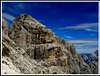 |
Madri dei Camosci / Gamsova Mati / Hohe Gamsmutter, 2518 m. Not marked, easy climb for normal ascent (I.) |
 |
Monte Nabois Grande / Veliki Nabojs, 2313 m. Marked routes from the east and west. Nice, panoramic scramble by the east ridge. Alpinistic skiing possible just from below the summit. | 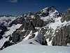 |
Cime Castrein / Kostrunove špice / Kastreinspitzen, 2502 m. Ridge mountain, connecting Viš group with Montaž group. Marked route. Rests from the World War I. |
 |
Iof Fuart / Viš / Wischberg, 2666 m. The highest summit of the subgroup, one of the two landmarks of the whole group. Strong and high fortress. Marked routes, good climbs, ski tours from the notches, alpinistic skiing from the top. The mountain hosts one of the most unusual routes - The Bands of Gods encircles the whole mountain. |
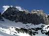
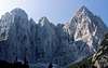
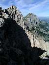
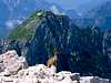
 Jôf Fuart / Viš group from the NE, from Cima del Cacciatore / Kamniti Lovec
Iof di Montasio Subgroup
 |
Cregnedul / Krni dol, 2351 m. Marked route. |  |
Punta Plagnis / Spice v Planji, 2411 m. Marked route. |
| Cima de la Puartate / Niznji vrhovi, 2436 m. Marked route. | 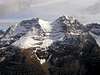 |
Modeon del Buinz / Špik nad Špranjo, 2558 m. Marked route. | |
 |
Foronon del Buinz / Špik nad Nosom, 2531 m. Marked route. | 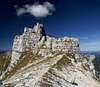 |
Cime Gambon / Špik nad Tratico, 2405 m. Not marked, scramble. |
 |
Cima della Terra Rossa / Špik Hude Police, 2420 m. Easy, marked route. | 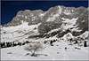 |
Modeon del Montasio / Špik nad Plazom, 2573 m. Hardly reachable. |
 |
Vert Montasio / Vrh Brda, 2661 m. Marked route and scramble. |  |
Iof di Montasio / Špik nad policami / Montaž, 2754 m. The highest and most magnificent mountain in the group. From Dogna valley rising more than 2200 m. Marked routes, some hard ferratas. Classic climbs. Hard alpinistic skiing from the top. |
 |
Iof di Sompdogna / Krniška Glavica / Koepfach, 1891 m. The summit above Sompdogna / Rudni vrh pass. Easilly reachable by a marked path. |
Monte Cimone Subgroup
 |
Curtissons, 2240 m. Not marked, easy climb (I.) and scramble. | 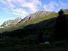 |
Monte Zabus / Zabus, 2244 m. Not marked, easy climb (I.) and scramble. |
 |
Monte Cimone / Strma peč, 2380 m. Nice, rocky summit, the highest in the subgroup. High walls with climbs. One quite easy marked route and one harder and long ferrata. | Iof di Goliz, 2288 m. | |
| Mucul, 2055 m. | Cuc di Valisetta, 2090 m. | ||
| Iovet Blanc, 1940 m. | Iof di Mezdi, 1911 m. |
Catena di Malborghetto
 |
Iof di Miezegnot / Poldanašnja špica / Mittagskofel, 2087 m. Marked route, many rests from the World War I. Nice panorama. | 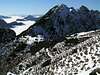 |
Monte Piper / Pipar, 2069 m. A three-headed, rugged peak. Marked route from the East (harder) and the West. |
 |
Due Pizzi / Dve špici / Zweispitz, 2008 m, 2046 m. Nice panorama, many rests from the World War I. Marked routes. | 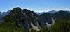 |
Monte Gosadon, 1969 m. Nice round tour. Great view on Montaž. |
 |
Cuel dei Piez, 1943 m. Rarely visited. Great view on Montaž. | Monte Sechieiz o Berda, 1839 m. | |
|
Monte Schenone / Lipnik, 1950 m. Marked path. Great view on Montaž. | 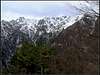 |
Iof di Dogna / Dunjski vrh, 1961 m. Remote, lonesome summit on the western part of the crest. Marked path. |
Mountaineering Highlights
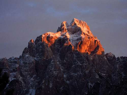
 On the summit of Jôf del Montasio
If you climb harder routes then come to Pellarini hut. In north walls of Jôf Fuart subgroup you will find nice climbs. The other destination is Valle di Riobianco, where Brunner hut and Gorizia bivouac support nice climbs in solid rock of the neighbouring mountains. Also Jôf del Montasio and Monte Cimone can offer some harder climbs.
If you like exposed paths, ferratas and if you're also not afraid of easy climbing (up do degree II) this group is just for you. You can hardly find a greater tour than traversing Jôf del Montasio. Jôf Fuart ascent is fine too. A specialty of this group are long ferratas, traversing whole mountain crests. Sentiero Goitan will lead you safely by the most beautiful ledges of the Jôf Fuart group. By it you will traverse the whole central part of Jôf Fuart subgroup. Ceria Merlone will lead you over the whole crest of Jôf del Montasio subgroup - almost all the time on top of it, from the very SE to the summit of Jôf del Montasio. Nice (very panoramic) is the route, traversing the whole Northern chain.
Also many routes on distinct summits are fine - see them on other SP pages.
If you just want to make a short hike to a panoramic summit, choose Cima del Cacciatore or Iof di Miezegnot.
For tour skiing Jôf Fuart - Jôf del Montasio group is not the best suited. The prevailing vertical character of summits, rocky peaks, even too steep southern slopes - all this doesn't allow easy tour skiing. Cima del Cacciatore offers a nice short ski tour, also the slopes above the Brazza hut (above Altipiano del Montasio), some ends of northern valleys - and that's more or less all. Yet, for the best skiers there are many specialties. From Spragna basin to the main summit by Cima di Terrarossa the longest couloir of Julian Alps ascends. It has 700 m of altitude, is 40-45 degrees steep, has a demanding exit and can be done only when there's no danger of avalanches. And for alpinistic skiing many summits above Altipiano del Montasio are appropriate.
A Glimpse in the History
In the distant past the high pastures of Altipiano di Montasio were far more important for local people and were also a matter of dispute between the people leaving on the south and on the north. The area of alpine pastures was two time bigger as it is today and more than 5000 cattle were kept there. Disputes were known already in the 13th century and lasted in a way till the World War I. A good example is the raid which happened in 1582. Some 200 men from the surroundings of Tarvisio stole a 600 headed herd of cattle from Atipiano meadows. Later Friulani people revenged and cut down the most beautiful trees in the Rio del Lago valley.
The Legend Of Pesamosca
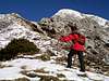
 Vlado Vujisic - From the East
In mountaineering circles the name of Osvaldo Pesamosca is well known. He was one of the legendary native guides of the famous explorer and poet of Julian Alps, Julius Kugy. At the end of 18th and start of 19th century Osvaldo Pesamosca was a true expert, the most complete guide of Furlania of his time. But less is known of his grandfather, Giuseppe Pesamosca. Winds of Western Julian Alps are still whispering only legends of this incredible man. He was living in the small village of Stretti, situated on a terrace above Raccolana valley. This is a wild place among vertical cliffs, steep meadows and high above the deep throat of Raccolana river bed. In 1859 Giuseppe was called into Austrian army, but refused the service and so became an outlaw against his will. He had to leave his home. Nobody knows how long, but several years (perhaps till 1866 or even longer) he was living like a wild man high on his beloved mountains. Smuggling, hunting, hiding in places which only he knew, high below the peaks of Jof Fuart, Montaz and Canin. He was living like a hermit, sleeping in small niches, on narrow ledges, below the abysses of Spragna and so became a prototype of what later became a proverbial character of the 'dark Pesamosca of Raccolana valley'. People saw him only rarely, coming down in valleys to resupply. Legends of this strange man soon arised, his nickname Lòuf (wolf) was inherited by his descendants who were proudly wearing it and they obviousely inherited also his mountaineering skills. According to Kugy, Giuseppe Pesamosca later went in America, where he also died. The Pesamosca line was dominating their wild mountains so much, that still today the saying is heard: "Dove il Lòuf è passato si può ancora passare, ma dove il Lòuf non è passato non si passerà mai". This would approximately mean: "Where the Lòuf has made it, it can be made again, but where the Lòuf hasn't made it, it can't (will not) be made!"
Getting There
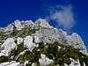
 Jôf Fuart group from the north
For the broader orientation (highways, railways, airports, ...) see the Eastern Alps GROUP page, and, because this is only a subgroup page, the Julian Alps page. On the map above you can see, that besides all the roads around the group, you can use a few (yellow ones) going into the group:
- From Sella Nevea you can reach the parking place on Altipiano del Montasio, 1502m.
- Through Dogna valley you can reach the Sella di Sompdogna pass, 1300m.
- From Pietratagliatta in Fella valley you can reach Malga Poccet, 1350m (north of Iof di Dogna).
- Through Valbruna valley you can reach the end parking place at 1004m.
All the above roads are toll free. Other roads are closed for public traffic. Some more important for mountaineering are on the map drawn in white. Some are only cart-roads, but could be used for mountain biking. Monte Santo di Lussari can be reached by a cable-car. For some tourist information see the Tarvisio tourist page.
Red Tape
There's no red tape in these mountains. Doesn't matter anyway - we should preserve nature in any case.
When To Climb
Months with the most stable weather are usually from July to October. For tour skiing the best months are from March to May. For weather see Wunderground - Tarvisio.
Huts and Camping
 ClaudioNC - Montaž group
- Rif. Guido Brunner, 1380 m. In Val Riobianco. From the main road in Val Rio del Lago 1 h 15 min.
- Bivacco Gorizia, 1950 m. In Val Riobianco. From the main road in Val Rio del Lago 3 h.
- Rif. G. Corsi, 1845 m, 0428.2013, 040.390025, 0428-68113. South of Iof Fuart. From Sella Nevea pass or from the main road in Val Rio del Lago 3 h.
- Rif. Divisione Julia - Nevea, 1142 m. Accessible by car.
- Rif. Pellarini, 1500 m, 0428-60135. From Saissera 2 h.
- Biv. D. Mazzeni, 1825 m. In Spragna basin. From Saissera 2 h.
- Rif. Brazza, 1670 m, 0432-797079. On Altipiano del Montasio. From the parking place 15 min.
- Rif. Attilio Grego, 1395 m, 0428-60111. Above Sella di Sompdogna pass. From the parking place 10 min.
- Casera Plan dei Spadovai, 1125 m. Above Dogna/Dunja road. Tel: 39 0433 70609. Cell: 39 347 9617215.
- Biv. C. Stuparich, 1650 m. Below Montaz N wall. From Saissera 2 h.
- Biv. Suringar, 2450m. On the big ledge in Montaz W wall. From Altipiano del Montasio parking place 3h 30min.
- Biv. Muschi, 1955 m. Above the wild Clapadorie gorge (below Montaz W wall). From the road in Dogna 3 h 30 min.
- Biv. M. Cimone, 2040 m. On the summit of Monte Cimone. From Altipiano del Montasio parking place 4 h.
- Biv. Cividale, 1414 m. Below the N wall of Monte Cimone. From the road in Dogna 2 h 30 min.
- Biv. Bernardis, 1830 m. Below Due Pizzi. From the road in Dogna 2 h.
- Ricovero Btg. Alpini Gemona, 1890 m. Below (SW of) Iof di Miezegnot. From the parking place on Sella di Sompdogna pass 1 h 30 min.
Maps
The two most recommended maps are: Tabacco, No. 18. Alpi Carniche Orientali, Canal del Ferro. 1:25000 Tabacco, No. 19. Alpi Giulie Occidentali Tarvisiano. 1:25000. For a broader overview also: Planinska zveza Slovenije, Julijske Alpe - Zahodni del. 1:50000.