
-
 42220 Hits
-
 97.08% Score
-
 65 Votes
|
|
Area/Range |
|---|---|
|
|
46.38000°N / 13.85000°E |
|
|
Hiking, Mountaineering, Trad Climbing, Sport Climbing, Via Ferrata, Skiing |
|
|
Spring, Summer, Fall, Winter |
|
|
9396 ft / 2864 m |
|
|
Overview
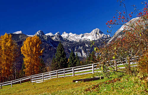
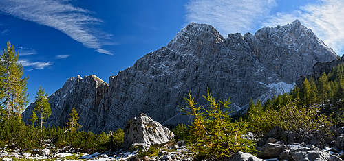
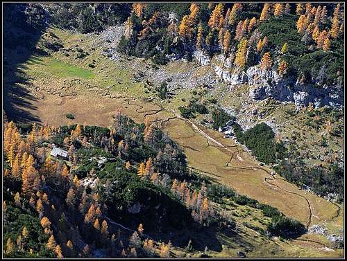
UIskovnica meadow
What's New On This Page?
- JUL 9th, 2021: Subpage about Pokljuka mountains created.
- SEP 21th, 2015: Geological Outline added.
- SP V3 design updated.
- DEC 24th, 2006: new pictures embedded.
- MAR 28th, 2005: Links to the new page inserted: Rž.
- FEB 13th, 2005: Links to the new page inserted: Zadnjiški Ozebnik.
The Purpose of This Page
On this page I would like to give an overview information of Triglav subgroup (Julian Alps), in order not to be repeated on all distinct summit pages. The map below links you to distinct summit pages on SummitPost! Regarding pictures and routes, this page is the place only for overall information.
General about Triglav Group
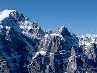
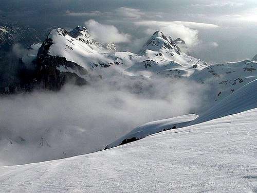
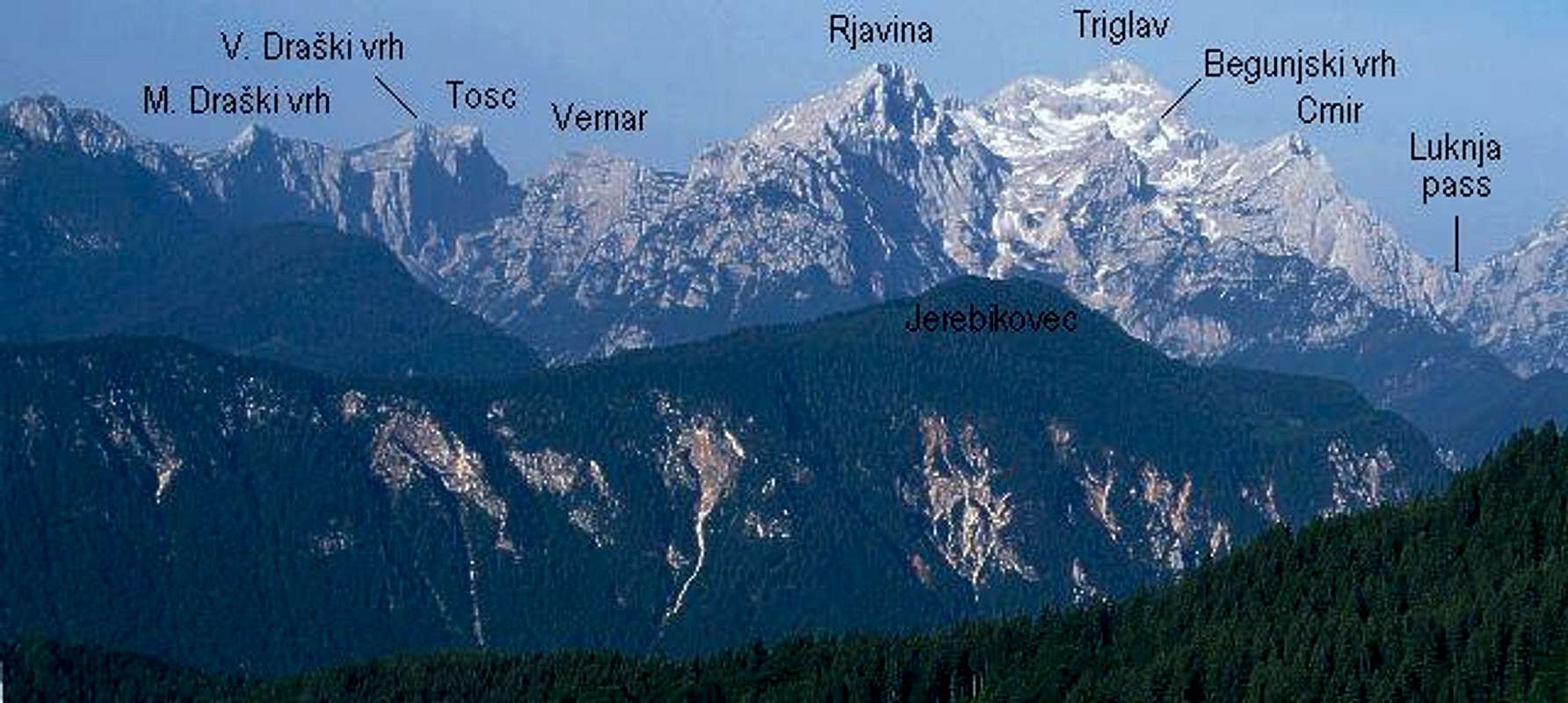 Triglav group from the NE, from the Karawanks |
Triglav Subgroup stands on the very NE part of Julian Alps, where these lower significantly to forehills (beyond Sava Bohinjka river) and to Gorenjska plane. Borders of the group are: Luknja pass - Vrata valley - Sava Dolinka valley - Sava Bohinjka valley - The Upper Bohinj valley - Voje valley - Mišeljska dolina (valley) - Hribarice plateau - Prehodavci Pass - Zadnjica valley - Luknja pass. All the highest peaks of this group are concentrated on its western part. In the central and southern part there's a broad high plateau, named Pokljuka, covered almost completely with beautiful forests and nice alpine meadows. On the NE part, beyond Radovna valley, there is a mountain range, or high plateau, named Mežaklja, which still belongs to Julian Alps, but its highest peak reaches only the altitude of 1593 m. |
Geological Outline
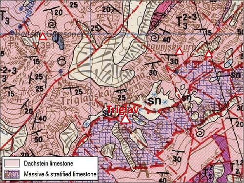
In the geological sense the Triglav group is not very complex. In a simplified version we could actually say that its mountains are built of Triassic limestone, some 205-235 million years old). Still scholars would find some interesting differences in those rocks.
Most of the massif - including the huge North Wall of Triglav and many mountain peaks - are made of the young Dachstein limestone (Norian and Rhaetian era). But the very summit of Triglav and also the broad area south of it are a bit older by origin (a few million years). Those massive, also layered limestones belong to the so-called "Slatenska plošča" ("Slatna Plate"), which is thrusted over the younger rocks. Finally, as it is typical for the whole group of Julian Alps, the northern parts of the group are made of stratified limestone and dolomitic rocks from the Carnian era (some 20 million years older than the Dachstein limestone). And that's basically it. Only some distinct rock structures in the group are even older - made of Ladinian limestone.
Still, this outline refers only to the high mountains. Describing the lower areas of the massif - down to the Gorenjska Plane around Bled - that would require a bit more time and details.
Some Geography and Characteristics of Mountains
Towards the summit
A part of Triglav North Face
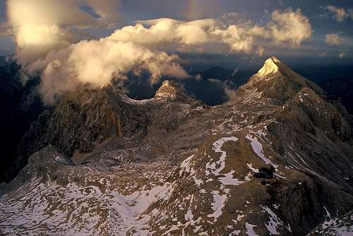
In the highest part of the group, some 1800 m above Vrata valley and above one of the most monumental rock walls of the whole Alps the summit of Triglav, 2864 m, stands. The summit massif has two side peaks, Mali Triglav, 2725 m, and Rjavec, 2568 m.
SW of Triglav, alone stands Šmarjetna glava, 2358 m, and beyond Dolič pass Kanjavec massif, 2568 m. The western shoulder of Kanjavec is Vršac, 2194 m, itself an unimportant peak, but with a beautiful north wall in which there are many hard climbing routes. Towards the south, Kanjavec lowers on Hribarice high plateau, 2350 m, where Thiglav subgroup is attached to Bohinj subgroup. Beyond Zadnjica valley there's also the massif of Zadnjiški Ozebnik, 2084 m, which officially also belongs to the Triglav group. SE of Hribarice a nice summit stands - Mišeljski konec, 2464 m, which starts a long ridge streching towards the east. This is Mišelj ridge, consisting of a few minor summits and finishing on the eastern end with Mišelj vrh, 2350 m and the throne of Koštrunovec, 2102 m. SE of Triglav there's one more ridge, streching towards the long crest above Pokljuka plateau - the highest summit in it is Vernar, 2225 m.
East of Triglav a high ridge goes towards Rjavina. The first two summits, Kredarica, 2541 m and Rž, 2538 m, would be less important, if on the first one there would not stand the highest hut in Julian Alps. So, from Triglav three ridges go towards the NE. From the summit of Triglav first only the edge of the huge N wall goes. Where it lowers, there's a place, named Prag. Beyond it the first mountain ridge begins with Begunjski vrh, 2461 m, continuing towards NE to the summit of Cmir, 2393 m. With Cmir this ridge comes to an end, because from Vrata valley up to the centre of Triglav massif a side valley goes, named Za Cmirom (=Behind Cmir).
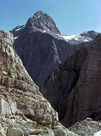
Rjavina
The second ridge goes parallelly to Begunjski vrh - Cmir ridge. It starts with Visoka Vrbanova špica, 2408 m, and lowers down to Spodnja Vrbanova špica, 2299 m, which is especially beautiful from Kot valley. But this ridge doesn't end like the first one. It lowers significantly, but continues over Požgana Mlinarica, 1873 m, which is still attractive and rocky, then over many lower summits, covered with woods, until it finishes near Mojstrana.
The most important is the third, Rjavina ridge. After Rž, there's a saddle Dovška vratca, 2254 m, beyond which the strong and nice Rjavina, 2532 m, begins. Further towards the NE of its highest summit in the strong ridge there are some more, also important summits: Luknja peč, 2245 m, Dimniki, 2101 m, Macesnovec, 1926 m, after which the ridge lowers and finally finishes at Radovna village.
And finally the last of high Triglav group crests, which on the SE rises above Pokljuka plateau. They are described on their own page - Pokljuka Group.
Beyond Bohinjska vratca (notch), 1979 m, the first high mountain is the fat Tosc, 2275 m. From this one the mountain chain goes allways towards the NE. Its N and NW walls are high, vertical rocks, very attractive for hard climbs, while its S slopes are more or less grassy, intermitted with some rocks. Next to Tosc there stands a beautiful pyramid of Veliki Draški vrh, 2243 m, Then the sharp Mali Draški vrh, 2132 m, Debeli vrh, 1962 m, Lipanski vrh, 1965 m and finally Debela peč, 2014 m. After this last important summit the crest lowers and after some minor summits it ends in Radovna valley. And the last two mountains to name. From this long crest two shorter side ridges go towards the south. The first one, the ridge of Ablanca, 2004 m, is south of Veliki Draški vrh and the second one, the ridge of Viševnik, 2050 m, is south of Mali Draški vrh.
Mountaineering Highlights
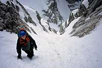
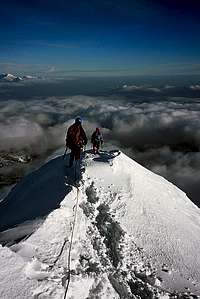
Over the N face in winter

Northern approaches
The most valuable mountaineering goal of the group is of course the summit of Triglav. The ascent from the north is a true feast for every fit mountaineer. If doing it in one day, the best option is by its NW ridge (Plamenice) and down by one of the other two trails. Doing this it, means some 1900 m of altitude up and the same down. For good climbers Triglav north wall is of highest value. In almost 5000 m wide and 1500 m high wall there are numerous routes of all difficulties.
If you sleep in one of the high mountain huts, nowadays the ascent on Triglav is not very difficult. Easy to medium hard ferratas lead up there. But once it was different. In the middle of 19th century the ridge between Mali and Veliki Triglav was still a razor sharp blade, where many good climbers of that time were "riding"!. This is how Ivan Tušek (1835-1877) describes the ascent, guiden by Ivan Škanter - Šest:
"...I was crawling ahead, in the Middle Šest went, behind him M. Anton was riding. Šest was in the middle so that he could hold one or the other if the depth would intend to pull him into its cold hug." And when they were on the most narrow place, also Šest needed to calm down: "When we reached a few meters long, very narrow ridge section, Šest said: 'Let's stop a moment, I really need to load my pipe'. And he took a pipe from one pocket, tobacco from the other one, and lit it with a sponge. We were horrified, looking at him how he stood on the narrow ridge above the immense void and manipulated calmly this."
Any other of big summits can be a valuable mountaineering goal. Nice marked trails/ferratas are on Rjavina, over Vrbanove špice ridge, over Cmir ridge, on Kanjavec and on Debela peč. Very rewarding are tours, where there is no trails, nor marks: Mišelj ridge, summits in the ridge above Pokljuka and many more distinct summits. See more about these possibilities on distinct mountain pages.
For hard climbs also other summits offer nice rock walls. here's first of all the wall from Tosc, over Veliki to Mali Draški vrh. Some possibilities are also in Rjavina north wall, and even in its SE walls (Teme). Also Debela peč is very popular. From Trenta side a special pearl for hard climbs (long routes!) is Vršac north and north-west wall.
Finally in Triglav massif there are some best possibilities for tour skiing in Julian Alps. Triglav itself can not be done with skis (only few extremely good skiers did it). But the whole area south of it offers nice terrains. Skiing down from Kredarica into Krma, from Kanjavec on Velo polje and over Bohinjska vratca into Krma, behind Cmir, and from almost any summit above Pokljuka plateau is highly enjoyable.
Other Places To See And Easy Hikes
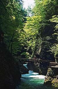 Vintgar gorge
|
Vintgar gorge north of Bled is great in spring. Radovna river made its way through 200 meters high rocks of neighbouring hills. In addition to Vintgar only, the whole Radovna valley is nice for doing a bike tour, or just hiking. Nice, lively river, old farms, a small artificial lake and the farm which was burnt during the World War II, when Nazis burnt alive 24 civilians, from 6 month old child to 81 year old man. |
||
 |
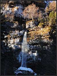 |
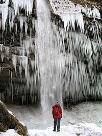
Peričnik waterfall in Vrata valley is easily reachable and is one of the most attractive ones in Julian Alps. If you have some time (15 more minutes) and energy, it's worth ascending by the marked path on top of it and a few minutes further to the higher (but smaller) waterfall. | |
Otherwise, the valleys, leading into the group are in detail described on the Triglav page. They all offer nice hikes.
Getting There
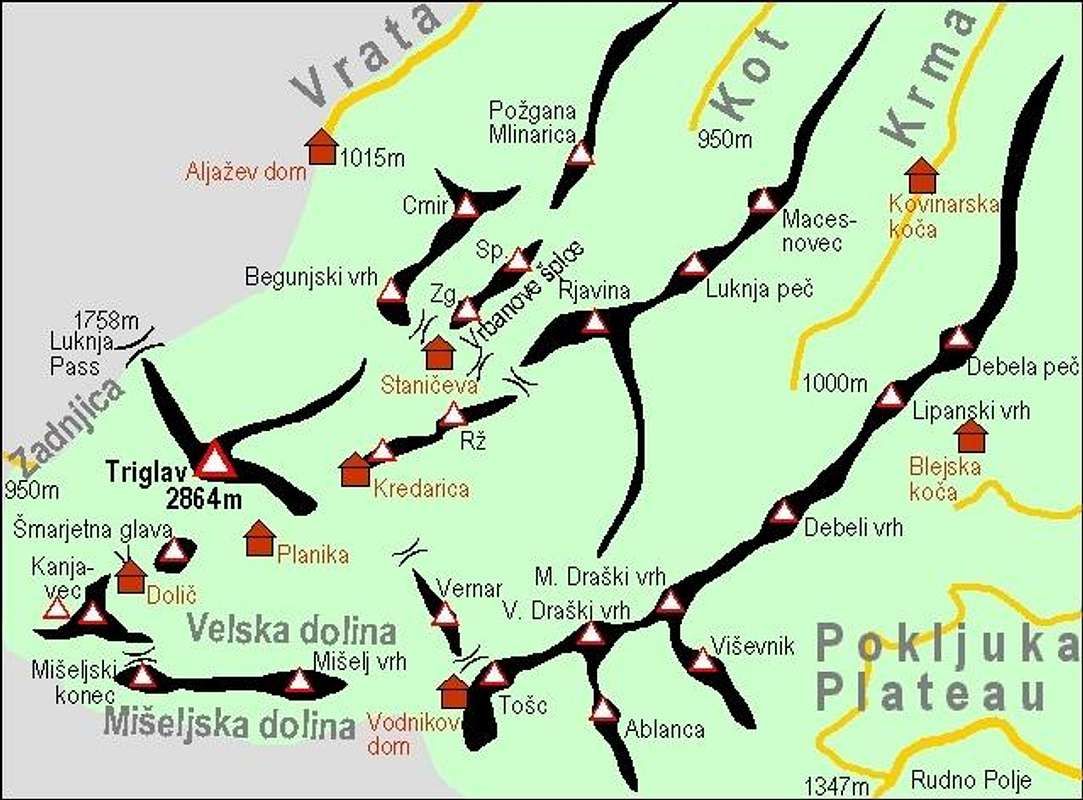
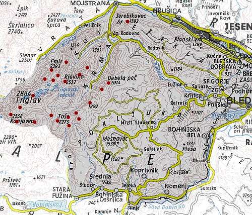 Triglav subgroup - access roads and main summits are clearly seen. |
For a broader orientation (highways, railways, airports, ...) see the Eastern Alps GROUP page, and, because this is only a subgroup page, the Julian Alps page. On the map left you can see that you can drive by car into all three valleys from the north: Vrata, Kot and Krma. Roads end on altitudes of about 1000m. In recent years there are strong voices that the road into Vrata valley should be closed for public traffic. But so far this hasn't been realised yet. In Vrata in summer there's also the bus connection. For mountaineering purposes also the Pokljuka plateau can be reached by good roads. They are all toll-free and the main road on Rudno polje is cleared also through the whole winter (unless desperately too much snow falls). From Bohinj valley, you can, besides driving on Pokljuka, drive a few kilometers also into Voje valley. And finally, from Trenta valley you can also drive by a narrow road into Zadnjica valley (for west approaches). Also Mežaklja side ridge can be accessed by car. |
Red Tape
The highest mountains are in the Triglav national park. So, please do everything to preserve nature!
Here are some links to web pages where information is also in English:![]() The official page of Triglav National Parc.
The official page of Triglav National Parc.![]() A kind of bi-lingual page with panoramic pictures of the area.
A kind of bi-lingual page with panoramic pictures of the area.![]() A page for waterfall enthusiasts.
A page for waterfall enthusiasts.
When To Climb
After the storm
Late spring / early summer
Months with the most stable weather are usually from July to October. For tour skiing the best months are from March to May.
For weather see here.
Even better site is wunderground - here's the direct link to Kredarica station, 2515m (below Triglav summit).
Camping & Huts
Camping in nature is forbidden. High on the mountain nobody will tease you if you just make it over the night (and of course not close to a mountain hut). In any case you should leave the nature unchanged. Otherwise camps are in Sava valley, in Trenta, in Bled and in Bohinj valley. For other touristic possibilities see the main Julian Alps page!
Mountain huts of Slovenian Mountaineering Association:
(1) Blejska koca na Lipanci, 1630m, (050) 633769, (050) 611903. Access route(s): From the parking place on Pokljuka in 45min - marked path.
(2) Kovinarska koca v Krmi, 870m, (050) 631989, accessible by car.
(3) Vodnikov dom na Velem polju, 1817m, +386(0)51 607 211.
(4) Zasavska koca on Prehodavci Pass, 2071m, Tel.: +386(0)50 614781 +386(0)41 844776.
(5) Trzaska Koca na Dolicu, 2151m, (050) 614780.
Access route(s):![]() From the Valley of 7 Triglav Lakes. This route was described by Velebit here. The relevant section is: Section 2) 7 Triglav Lakes hut - Koca na Dolicu hut: 3.30h. The variant from Prehodavci to Dolic over the N face of Kanjavec is described here.
From the Valley of 7 Triglav Lakes. This route was described by Velebit here. The relevant section is: Section 2) 7 Triglav Lakes hut - Koca na Dolicu hut: 3.30h. The variant from Prehodavci to Dolic over the N face of Kanjavec is described here.![]() From Trenta valley / Zadnjica valley. This route was described by Velebit here. The relevant section is: a.) Zadnjica - Koca na Dolicu hut - Triglav. 5h.
From Trenta valley / Zadnjica valley. This route was described by Velebit here. The relevant section is: a.) Zadnjica - Koca na Dolicu hut - Triglav. 5h.![]() From Vrata over Luknja pass. From Aljazev dom, 1015m, (hut) we follow the marked path alon Triglav's N face towards SW and ascend Luknja pass, 1758m. Now we must descend more than 250m down towards Zadnjica valley, until we reach the path, described above. 6h.
From Vrata over Luknja pass. From Aljazev dom, 1015m, (hut) we follow the marked path alon Triglav's N face towards SW and ascend Luknja pass, 1758m. Now we must descend more than 250m down towards Zadnjica valley, until we reach the path, described above. 6h.![]() From Vodnikov dom, 1817m. From the hut we descend to Velo Polje meadow, 1700m, and go towards W all the way by the beautiful Velska dolina (valley). Approaching the upper end, we don't continue on the same direction to Hribarice Pass, but turn instead right (towards N) and ascend Dolic Pass and the hut beyond it. 2h.
From Vodnikov dom, 1817m. From the hut we descend to Velo Polje meadow, 1700m, and go towards W all the way by the beautiful Velska dolina (valley). Approaching the upper end, we don't continue on the same direction to Hribarice Pass, but turn instead right (towards N) and ascend Dolic Pass and the hut beyond it. 2h.
(6) Dom Planika, 2401m, (04)5744069, (050) 614773,
(7) Triglavski dom na Kredarici, 2515m, (04) 2023181,
(8) Stanicev dom, 2332m, (050) 614772,
(9) Aljazev dom v Vratih, 1015m, (04) 5891030, (031) 384011, (031) 384013,
(10) Dom v Vojah, 690m, (04) 57 23 213, (051) 308 959,
(11) Planinska koca na Uskovnici, 1154m, (031) 341 814.
Existing SummitPost Pages
Northern neighbours of Triglav
Kredarica views
2864m - Triglav,
Not to disregard other pages, but Triglav page is the best example of high quality SummitPost page! It is almost every day updated (weather conditions), there you will find any information about the mountain and its surroundings.
2568m - Kanjavec,
2538m - Rz,
2532m - Rjavina,
2461m - Begunjski vrh,
2408m - Vrbanove spice,
2393m - Cmir,
2350m - Miselj vrh,
2225m - Vernar,
2194m - Vrsac.
2084m - Zadnjiski Ozebnik.
The story of Malo polje creek
Malo polje creek
South of Triglav there is Velo polje, a wonderful, but predominantly dry high alpine valley, surrounded with white limestone mountains. Meteor waters soon disappear in limestone, only on the very east, below Vernar, there are a few modest water sources - sufficient that Velo polje became the highest alpine pasture in Triglav group. There's also some water on the nearby Malo polje and on Mišeljska planina, but all of it soon disappears in gravel morraines, left by ex glacier. The beauty of that country is in green meadows, full of flowers, in many picturesque larch trees, in a small creek, meandring across the plane and in white rocks of the neighbouring summits. And there is a story, explaining why the cute creek has so many meanders on that meadow:
The creek is God's work. It has been flowing lively across than high alpine meadow since ever, surrounded by a heavenly nature. Mountain flowers were mirroring in its waters, wild animals came to drink, even White Women and Naiads liked to sit by the creek, washing their beautiful hair in its clear waters. The creek was so important and admired, that he got haughty. He became arogant and the God decided that it must get penance. At the end of Malo polje it must disappear into the ground to get cleaned. The unfortunate creek could not leave the blossoming meadow. It stopped sixty times and looked back on the Heaven below Triglav, but at the end it had to fulfill God's command and descend towards the Hell. Only down in the valley of Voje it could appear again on surface - all cleaned in the form of Mostnica waterfall - and continue its way through the wild beauty of Korita.
The More Remoted History of This Page
![]() January 30th, 2005 - Links to the new page inserted: Vrbanove spice.
January 30th, 2005 - Links to the new page inserted: Vrbanove spice.![]() December 1st, 2004 - Links to the new page inserted: Begunjski vrh.
December 1st, 2004 - Links to the new page inserted: Begunjski vrh.![]() November 27th, 2004 - Links to the new page inserted: Mali Draski vrh.
November 27th, 2004 - Links to the new page inserted: Mali Draski vrh.![]() November 23rd, 2004 - Links to the new page inserted: Tosc.
November 23rd, 2004 - Links to the new page inserted: Tosc.![]() November 17th, 2004 - Links to two new pages inserted: 2393m - Cmir and 2350m - Miselj vrh.
November 17th, 2004 - Links to two new pages inserted: 2393m - Cmir and 2350m - Miselj vrh.![]() November 9th, 2004 - Links to the new page inserted: Vrsac.
November 9th, 2004 - Links to the new page inserted: Vrsac.![]() November 7th, 2004 - Initial set up of the page.
November 7th, 2004 - Initial set up of the page.