
-
 5562 Hits
-
 87.76% Score
-
 25 Votes
|
|
Mountain/Rock |
|---|---|
|
|
45.72580°N / 6.80852°E |
|
|
Mountaineering |
|
|
10210 ft / 3112 m |
|
|
Overview
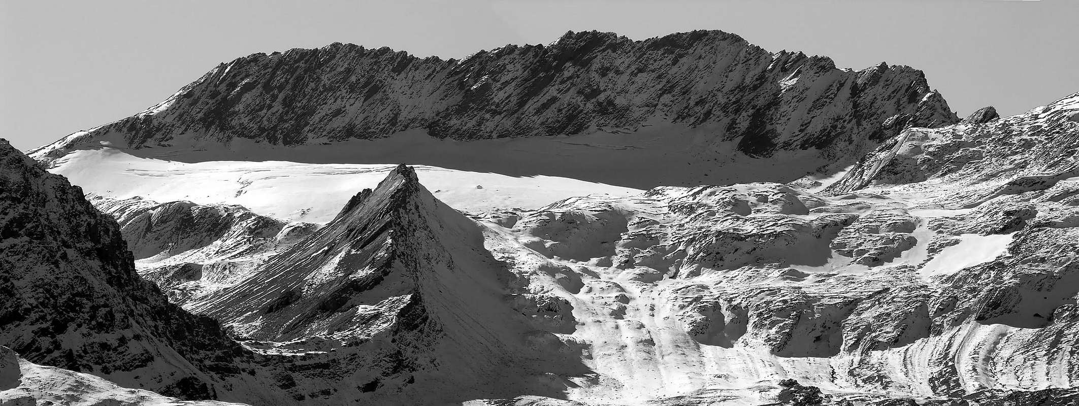
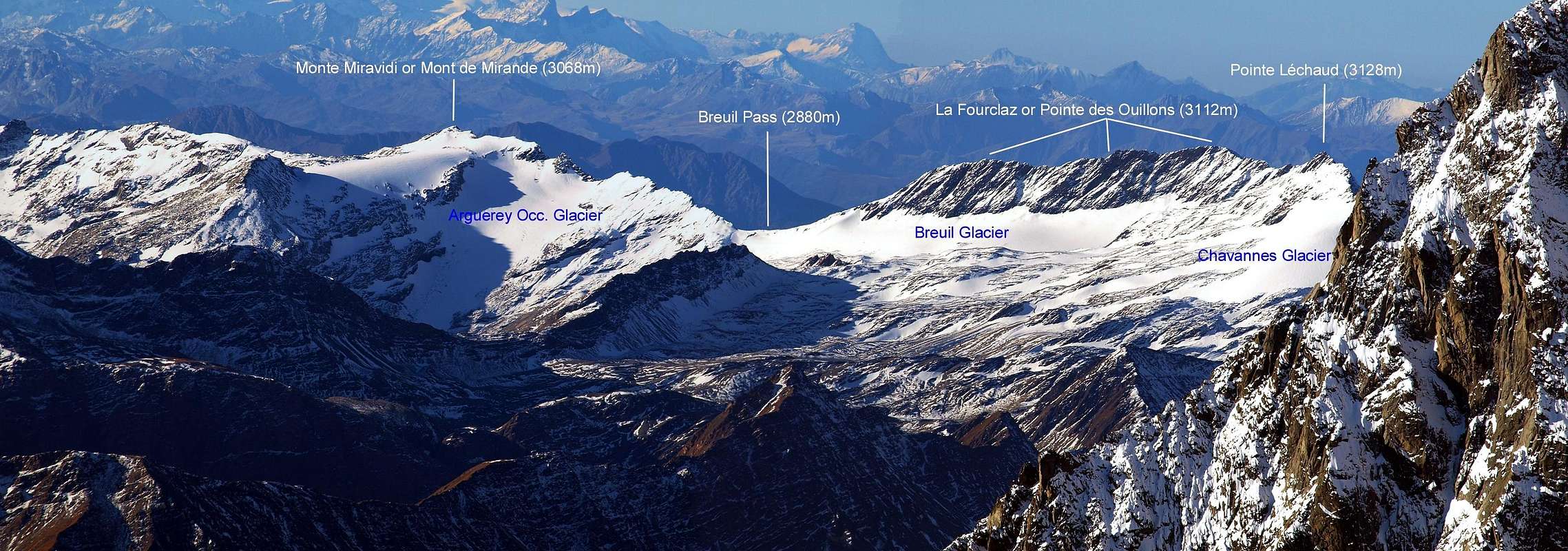
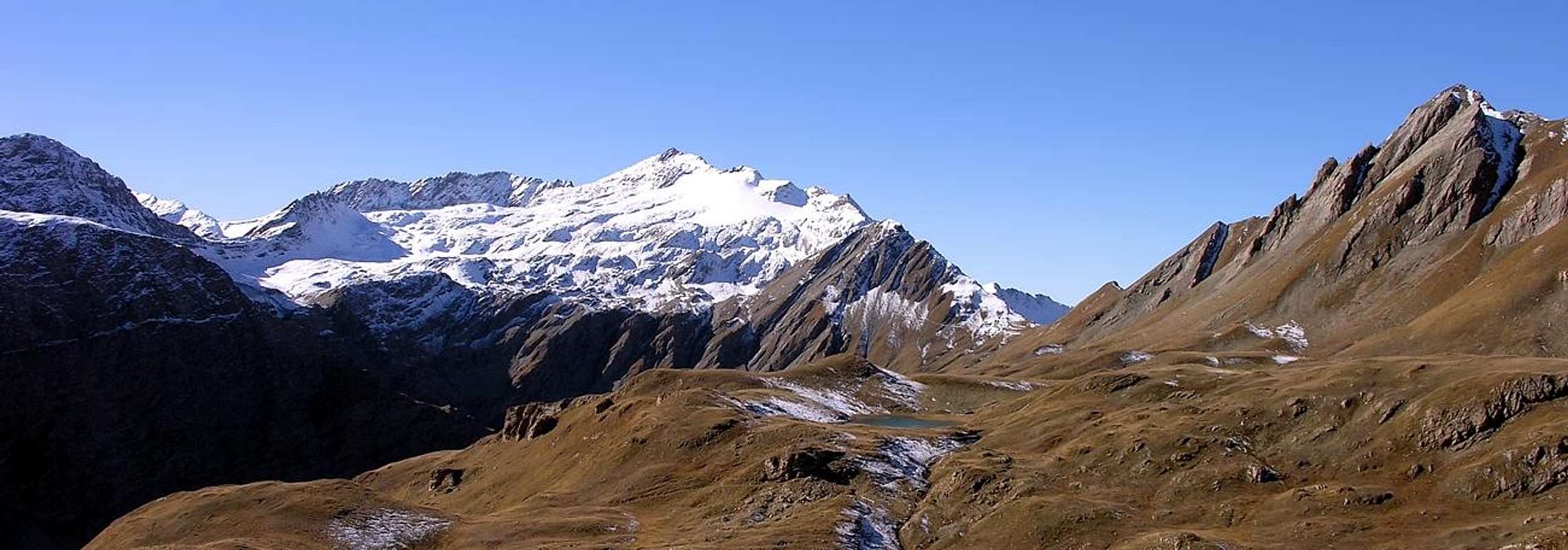
It is the second peak, after the Pointe Léchaud (3.127m) the most elevated of this small but wide mountainous subgroup, on the long crest of border between Italy and France that from the Footstep of the Small St. Bernard (2.185m) goes up to the of the Seigne Pass (2.694m), where it begins the great Chain of the Mount Blanc. You are more precisely situated to South of the same one, where the direction crest S-SE fold in N-NE, what important topographical knot discreetly. In effects from the Fourclaz (this is the name of a series of small points, the most greater of which it is said Pointe des Ouillons (3.112m) while the Italian side always results turned to the Valley of the Breuil (secondary but belonging to the Valley of La Thuile), the French sector is separated in two: to N the Mountains of the Seigne in the Valley of the Glaciers, to S the big "Vallone" of Versoyen. Its rock is ancient and shattered and surely not suited for the climb; her slopes therefore they result dangerous and exposed to the falling of stones. Only the long run in crest from the With the Breuil (2.882m) to the small depression among the same one and the Little Léchaud (2.973m) you can be considered profitable, if nothing else for the splendid ones, uncommon and unusual seen on the Mount Blanc. The simplest or normal route remains, if nothing else for the brevity of the slope, the Oriental Slope that dirties the underlying Breuil Glacier with a scarp of broken and steep rocks. For the aforesaid motives it is poorly known top and still less frequented; it deserves the combining of slope they govern the neighbor Léchaud Point, by departure from of Vallone Tormotta (described of the approach of you see), both from that more to East also called of Breuil Valley, or from the of Chavannes Valley, site anymore to North, by crossing in sense North/South. The ascent develops him in wild and uncontaminated, as well as rich environment of waters however. They are present four glaciers (five also considering him the of Glacier Chavannes, situated however in the homonym valley to the slopes of the Point Léchaud therefore beyond the of Hill Low Western Bassa Serra), numerous glacial little loches of every form and dimension and launchings fresh torrents; even the fauna is discreetly abundant and, among the various observations, it doesn't result rare to come upon him in the regal flight of the eagle or the vulture also called gypaetus.
First Ascents
- First on the summit: Unknown.
- In winter: Unknown.
- GREAT TRAVERSE from Chavannes Pass (2.603m) to Chavannes Pass: Léchaud Mount (2.805m) - Quota 2.956m, 3.000m, 3.061m - Léchaud Point (3.127m) - Petit Léchaud (2.973m) La Fourclaz or Ouillons Point (NW 3.112m, Central 3.090m, SE 3.061m) - Breuil Pass (2.882m) - Quota 3.008m - Miravidi Mount (3.068m) - Veys Pass (2.984m) - Glaciers Point (3.023m) - Western Bassa Serra Pass (2.900m) - Glacier of Chavannes Lakes (2.713m, 2.631m) - Chavannes Pass: Osvaldo Cardellina and Giuseppe Lamazzi (integral), Marco Cossard, Raffaella Pellizzari and Sandro Plat (leaving out La Fourclaz three Summits), (Sep 28th, 1980), in day from Chavannes Valley.
 |
 |
Getting There
BY CAR:- From the Morgex exit of Motorway A5 (921m), continue for about 3 km on SS.26 towards Pré Saint Didier (1.017m). SS.26 becomes the main street of the small city and then continues toward Colle del Piccolo San Bernardo (2.188m). After several hairpins, and past the Villages of Elevaz (1.302m) and la Balme (1.309m) reach the famous ski resort of La Thuile (1.441m). Turn left on the bridge that crosses "Dora di La Thuile", a go on along the same road continue to rise along the SS.26, which leads to the Piccolo San Bernardo Pass to Lake Verney (2.088m) just below the pass.
- Dall'uscita dell'Autostrada A5 nel comune di Morgex (921 m) proseguire per circa 3 km lungo la SS.26 verso il Paese di Pré Saint Didier (1.017 m), addentrarsi nella via centrale del paese e proseguire sempre lungo la SS.26 che porta al Colle del Piccolo San Bernardo (2.188 m). Dopo numerosi tornanti e superate le Frazioni di Elevaz (1.302 m) e la Balme (1.309 m) si giunge alla famosa località sciistica di La Thuile (1.441 m). Svoltare a destra sul ponte che attraversa la "Dora di La Thuile", continuare a salire lungo la SS.26 che conduce al Colle de Piccolo San Bernardo fino al Lago di Verney (2.088 m) sito appena sotto il colle.
- Aeroporto "Corrado Gex" Saint Christophe (Aosta).
Approach
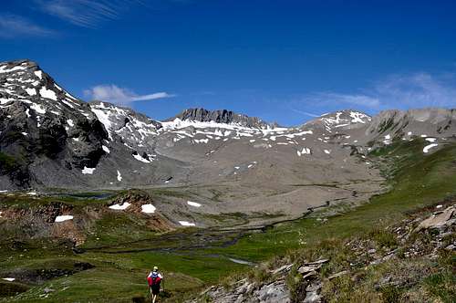
From parking (2.098m), near the Verney Lake (2.088m), by Northwest direction and groundroad to descend briefly to of same effluent (Lake Torrent) in quota 2.079m; in fork of same (continued in Northeast toward nearby Lechepré Pasture, (2.017m) with other three paths, to choose the first in left and, by before SW direction, after North to reach the Higher Verney Lake (2.280m). Turning in right (East) and passing between the same and a tiny lake to arrive at a cross with principal path, in the junction of two small torrents. Continue in North-northeast to Torvéraz Alp (variant), also, always by the same and NW direction, to small basin, with little lake, sited below S Slopes of small, but smart, Red Point (2.659m); to go up higher "colletto" (= small and round pass), straight away in West of same (2.551m). To like this "penetrate" into Tormotta(z) Vallon (= great alpine valley), forwarded the Breuil, true and own; leaving in left (West) two of Red Point mini lakes to reach the effluent in quota 2490m~, to be transformed the same, immediately afterwards, the tributary of more important following Tormotta two Lakes (2.486m the major), below of typical "great bread" Punta Tormotta (2.686m). To wade across, non always easily (above all in evening return for considerable of waters a rise) getting in gravely tableland, amongst various lakes; by North direction and scarce traces to join with Arguerey Torrent, encircled by numerous and with the same name small lakes, in quota 2.436m (E; 2h'30).Dal parcheggio (2.098 m), presso il Lago di Verney (2.088 m), con direzione NW e strada poderale scendere brevemente verso l'emissario dello stesso (Torrent du Lac) a quota 2.079 m; all'incrocio della stessa (che continua a NE verso la vicina Alpe Lechepré; 2.017 m) con altri tre sentieri, prendere il primo di sinistra e, con direzione prima SW e poi N, raggiungere il Lac de Verney Dessous (2.280 m). Aggirandolo sulla destra (E) e transitando in mezzo tra lo stesso ed un minuscolo laghetto, pervenire all'incrocio con il sentiero principale, vicino alla congiunzione di due torrentelli. Continuare verso N-NE verso l'Alpe di Torvéraz (variante), oppure sempre con lo stesso, e con direzione NW, verso il piccolo bacino con laghetto posto alle pendici S della piccola, ma elegante, Pointe Rouge (2.659 m); risalire al soprastante colletto, subito ad W della stessa (2.551 m). Entrare così nel Vallone della Tormotta(z), anticipatorio a quello vero e proprio del Breuil; lasciando a sinistra (W) i due minilaghetti de la Pointe Rousse, raggiungerne l'emissario a quota 2.490 m~, divenendo lo stesso, subito dopo, immissario dei ben più importanti Laghi della Tormotta (2.486 m il maggiore), ai piedi del caratteristico "panettone" della Punta Tormotta (2.686 m). Guadare, non sempre facilmente (soprattutto al ritorno serale per il notevole aumento delle acque) entrando nel ghiaioso altipiano tra i laghi; con direzione N e scarse tracce raggiungere il Torrente di Arguerey, circondato dai numerosi ed omonimi laghetti, a quota 2.436 m (E; 2h'30).
|
Routes
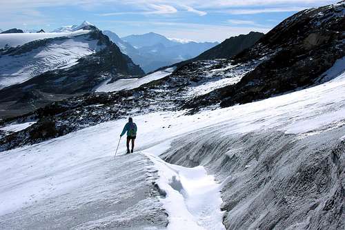
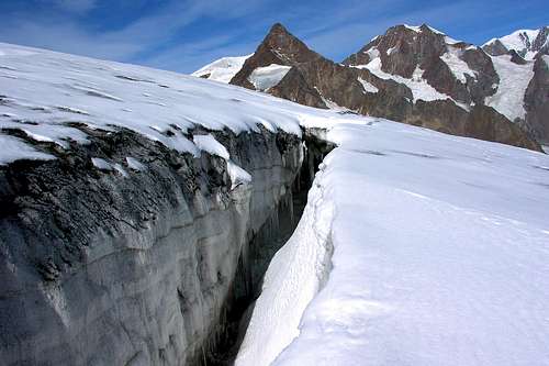
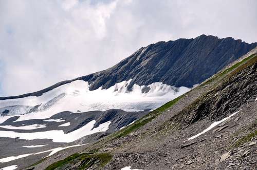
A) - E Slope: from the Little ponds of Arguerey, to quota meters of 2.436 to continue toward N-NW in the middle of the sundry Streams of the Lochs Glacier of Arguerey, coming from the Northern Glacier of Arguerey and from the Glacier of the Breuil; to laboriously climb, without trace for deposits and moraines in not excessive inclination, reaching the little ponds to quota 2.528m, or Higher Lacks Glacier of Arguerey; from these, after having doubled to West the quota 2.505m the through the various ramifications of the Stream of the Breuil to get in himself in the real homonym valley, leaving on the right (Of it) the various quotas of the Crest S-if of the West Point of the Low Greenhouse as well as the homonym Western Pass. Always for moraines or snowfields to gradually go himself with direction NW on the Glacier of the Breuil, that is reached to quota 2.860/70m~, near a little lake with two cornets and situated among the Petit Léchaud (2.973m) to NW and the Pointe des Ouillons (3.112m) to SW. To cross the glacier toward Or in almost level route (attention presence of some crevasses) and, with a gradient of about fifty meters, to easily go himself against the Oriental Wall of the Fourclaz. To go up again an earthy gully and of splinters rocks broken and enough steep mixed through to dark slope dangerous than not difficult (attention to shift stones on who comes behind!); to go out near the Pointe des Ouillons (3.112m), the most elevated of the long Crest of the Fourclaz, and through a brief crossing on you space out reddish to reach her (EE/A; F+; 2h'00; altogether 4h'30/5h'00). DESCENT: for the same street returning also by traverse to the Pass of the Breuil (2.882m), for the itinerary B, or, and surely better, completing the crossing toward North, with descent to the Saddle 2.950m around, immediately precedent the Little Léchaud (2.973m).A) - Per il Versante E: dai Laghetti di Arguerey, a quota 2.436 metri proseguire verso N-NW in mezzo ai varii Torrenti dei Lacs du Glacier d'Arguerey, provenienti dal Ghiacciaio Settentrionale d'Arguerey e dal Ghiacciaio del Breuil; salire faticosamente, senza traccia per detriti e morene in non eccessiva pendenza, raggiungendo i laghetti a quota 2.528 m, o Lacs Supérieurs du Glacier d'Arguerey; da questi, dopo aver doppiato ad Occidente la quota 2.505 m, attraverso le varie diramazioni del Torrente del Breuil introdursi nel vero e proprio omonimo vallone, lasciando sulla destra (NE) le varie quote della Cresta S-SE della Punta Ovest della Bassa Serra nonché l'omonimo Colle Occidentale. Sempre per morene o nevati portarsi gradualmente con direzione NW sul Ghiacciaio del Breuil, che si raggiunge a quota 2.860/70 metri nei pressi di un laghetto con due cornetti e situato tra il Petit Léchaud (2.973 m) a NW e la Pointe des Ouillons (3.112 m) a SW. Attraversare il ghiacciaio verso O in quasi falsopiano (attenzione presenza di alcuni crepacci) e, con un dislivello di una cinquantina di metri, portarsi facilmente contro la parete Orientale della Fourclaz. Risalire un canalino terroso e di frantumi frammisti a rocce rotte ed abbastanza ripide tramite una salita più pericolosa che non difficile (attenzione a smuovere pietre su chi viene dietro!); uscire presso la Pointe des Ouillons (3.112 m), la più elevata della lunga Cresta della Fourclaz, e per mezzo di una breve traversata su scaglioni rossastri raggiungerla (EE/A; F+; 2h'00; in totale 4h'30/5h'00). DISCESA: per la stessa via oppure attraversando al Colle del Breuil (2.882 m), per l'itinerario B oppure, e sicuramente meglio, completando la traversata verso N con discesa alla Sella 2.950 m~, precedente il Petit Léchaud (2.973 m).
B) - SE Crest through the Breuil Pass: from the entry of the real Vallone of the Breuil to quota 2.600m~ to continue verse NW, there where the torrent divides him in two branches in quota 2.675m around; abandoning on the right the route of the precedent itinerary, to decidedly address instead him to West entering a debris-morainic little valley. To go up again him among grassy backs and slant formed by splinters having to the left or South the Northern Glacier of Arguerey and to the right or North the Glacier of the Breuil; to reach the conjunction among the two to quota 2.825m~ and from this point shortly time the Breuil Pass (2.882m; 1h'00 from the alternative 2.436m, near the Little Loches of Arguerey), sets to horse among the Miravidi Mountain (3.068m) and her before the three constituent points The Fourclaz (3.061m). To begin too much not the slope through her steep SE Crest of this last reaching the Antesummit of it South (3.020m~), easily and shortly time. From this point the run becomes more airplane and with reddish rocks and routs (I°/II° - on the thread of crest) and overcoming in succession four small carvings or little saddles to reach the Point if or Southern (3.061m). To continue in crest going down along the edge of the same one, or revolving to the right at times and sometimes to the left some asperities, reaching a more marked saddle (3.040/45m~), later which the crest raises again him; to reach the Central Point (3.090m), with the same characteristics of run and peers difficulty. To cross the four turrets summital and to again begin to go down; to climb over a rocky terrace, pronounced more (also III°, if crossed on the thread), a last small point reaching the saddle, less pronounced of the preceding one, following (3.070/75m~). With more linear run to reach the most elevated Peak of The Fourclaz and known as Ouillons Point (3.112m; 1h'00/1h'15 and also more, according to the select route or of the possible "trickeries" or avoidances in crest; in total 5h'30/6h'00). DESCENT: for the same street returning to the Pass of the Breuil 2.882m, for the itinerary A, or, and surely better, completing the crossing toward North, with descent to the Saddle 2.950m~, precedent the Little Léchaud (2.973m).
B) - Per la Cresta SE dal Colle del Breuil: dall'ingresso del vero e proprio Vallone del Breuil a quota 2.600 m~ proseguire verso NO, là dove il torrente si divide in due rami in quota 2.675 m circa; abbandonando sulla destra la via del precedente itinerario, indirizzarsi invece decisamente ad O entrando in un valloncello detritico-morenico. Risalirlo tra dossi erbosi e pendii formati da frantumi avendo a sinistra o S il Ghiacciaio Settentrionale di Arguerey ed a destra o N-NO il Ghiacciaio del Breuil; raggiungere la congiunzione tra i due a quota 2.825 m~ e da questo punto in breve tempo il Colle del Breuil (2.882 m; 1h'00 dal bivio 2.436 m presso i Laghetti di Arguerey), posto a cavallo tra il Monte Miravidi (3.068 m) e la prima delle tre punte costituenti La Fourclaz (3.061 m). Iniziare la salita tramite la non troppo ripida Cresta SE di quest'ultima raggiungendone l'Antecima S (3.020 m~), facilmente ed in breve tempo. Da questo punto il percorso diventa più aereo e con rocce rossicce e rotte (I°/II°- sul filo di cresta) e superando in successione quattro piccoli intagli o sellette raggiungere la Punta SE o Meridionale (3.061 m). Continuare in cresta scendendo lungo il filo della stessa, o aggirando a volte a destra e talora a sinistra alcune asperità, raggiungendo una più marcata sella (3.040/45 m~), dopo la quale la cresta si rialza; arrivare alla Punta Centrale (3.090 m) con le stesse caratteristiche di percorso ed uguali difficoltà. Attraversare le quattro torrette sommitali ed iniziare nuovamente a scendere; scavalcare un gradone roccioso, più pronunciato (anche III° se percorso sul filo), un ultima piccola punta raggiungendo la sella, meno pronunciata della precedente, successiva (3.070/75 metri~). Con percorso più lineare arrivare alla Vetta più elevata de La Fourclaz e conosciuta come Pointe des Ouillons (3.112 m; 1h'00/1h'15 ed anche di più, a seconda del percorso scelto o degli eventuali aggiramenti in cresta; in totale 5h'30/6h'00). DISCESA: per la stessa via tornando al Colle del Breuil (2.882 m), per l'itinerario A oppure, e sicuramente meglio, completando la traversata verso N con discesa alla Sella 2.950 m~, subito antecedente il Petit Léchaud (2973 m).
C) - By the NE Ridge from the Saddle 2.975m~: with the preceding Route A, always through moraines or snowfields to gradually go herself with direction NW on the Glacier of the Breuil, that is reached to quota 2.860/70m~, near to little loch with two cornets and situated among the Petit Léchaud (2.973m) to NW and the Pointe des Ouillons (3.112m) to SW. To cross the glacier toward NW in almost false level route (attention presence of some crevasses) and, with a gradient of hundred meters, to easily go herself against the small one and not too accented Saddle 2.975m~, that separate the two points above you mention, easily attainable on this slope and that it falls with a wall of broken rocks and therefore not usable on the opposite slope or Vallon of the Seigne Mountain, on of Glaciers Valley in French. Turning to SW to go up again at first its sharp Crest climbing over a quota, then revolving to the left a minuscule tooth reaching a triangular and following quota; from this the crest feathers him reaching a strong shoulder and a following turret (continuous passages of I°+ and II° and wanting, on the thread there crest, also III°-/III°), precedent a small rounded of saddle. From this point the crest becomes more jagged and, overcoming a half dozen of elevations more or less of the same height, with the same technical difficulties, it reaches the terminal line that, with more linear slope, hands des to the Peak or Pointe Ouillons (3.112m; 1h'00/1h'15 and also more, according to the possible avoidances in crest; in total 5h'00/6h'00). DESCENT: for the same route returning to the Saddle 2.975m~, or crossing and in opposite sense to go herself to the Pass of the Breuil (2.882m), by the itinerary B; or, and surely to dissuade despite a more rapid descent on the Glacier of the Breuil, through the itinerary A., that leaves many doubts for the due dangerousness to possible falls of stones to be qualified as By Normal.
C) - Per la Cresta NE dalla Sella 2.975 m~: con la precedente Route A, sempre per morene o nevati portarsi gradualmente con direzione NW sul Ghiacciaio del Breuil, che si raggiunge a quota 2.860/70 metri nei pressi di un laghetto con due cornetti e situato tra il Petit Léchaud (2.973 m) a NW e la Pointe des Ouillons (3.112 m) a SW. Attraversare il ghiacciaio verso NO in quasi falsopiano (attenzione presenza di alcuni crepacci) e, con un dislivello di un centinaio di metri, portarsi facilmente contro la piccola e non troppo accentuata Sella 2.975 m, atta a separare le due punte sopra menzionate, facilmente raggiungibile su questo versante e precipitante con una parete di rocce rotte e quindi non utilizzabile sul versante opposto o Montagne de la Seigne, sopra la Valle dei Ghiacciai in Francia. Volgendo a SW risalire l'affilata Cresta NE dapprima scavalcando una quota, poi aggirando a sinistra un minuscolo dente e raggiungendo una triangolare e successiva quota; da questa la cresta si impenna raggiungendo un robusto spallone ed una successiva torretta (continui passaggi di I°+ e II° e volendo, sul filo ci cresta, anche III°-/III°), precedente una piccola sella arrotondata. Da questo punto la cresta diventa più frastagliata e, superando una mezza dozzina di elevazioni più o meno della stessa altezza con le medesime difficoltà tecniche, raggiunge il tratto finale che, con salita più lineare, porta alla Vetta o Pointe des Ouillons (3.112 m; 1h'00/1h'15 ed anche di più, a seconda degli eventuali aggiramenti in cresta; in totale 5h'00/6h'00). DISCESA: per la stessa via tornando alla Sella 2.975 m~, o attraversando ed in senso opposto portarsi al Colle del Breuil (2.882 m) per l'itinerario B; oppure, e sicuramente da sconsigliare nonostante una discesa più rapida sul Ghiacciaio del Breuil, tramite l'itinerario A, che lascia molti dubbi per la pericolosità dovuta a possibili cadute di pietre per essere qualificata come Via Normale.
 |
 |
Difficulty
These routes can be considered from EE/A/F+ up to A/PD-.Gli itinerari sono da classificarsi da EE/A/F+ sino a A/PD-.
MAPS:
Equipment for the Route
Standard mountaineering equipment.Campings
Remember that free camping is forbidden (except for emergency reasons, over 2.500m, from darkness until dawn).Mountain Conditions
- You can get meteo information at the official site of the Regione Valle d'Aosta:
- Valle d'Aosta Meteo
- Meteo: You can find more weather information on the website 3B Meteo:
- Meteo Colle del Piccolo San Bernardo
Webcam
- WEBCAM on Aosta Valley:
- Webcam
Books and Maps
BOOKS:- "Guida dei Monti d'Italia–Alpi Graie Centrali", di Alessandro Giorgetta - Club Alpino Italiano/Touring Club Italiano, 1985 (in Italian).
- "Guida delle Alpi Occidentali", di Giovanni Bobba e Luigi Vaccarone C.A.I. Sezione di Torino Volume II (parte II), 25 Maggio 1896.
- "Diari Alpinistici" di Osvaldo Cardellina e Indice Generale accompagnato da Schedario Relazioni Ascensioni 1964-2019 (inediti).
 |
 |
 |
- Kompass "Gran Paradiso Valle d’Aosta Sentieri e Rifugi" Carta turistica 1:50.000.
- L'Escursionista "La Thuile-Piccolo San Bernardo" (carta n° 2) 1:25.000.
- A.I.A.T. La Thuile, "La Thuile Pianta dei Sentieri", 2004 (Plastico).
- Carta Comunità Montana "Valdigne e Mont Blanc Les Sentiers", 2001 1:50.000.
- L'Escursionista "Monte Bianco Courmayeur Carta dei Sentieri" (n° 1) 1:25.000.
- I.G.C. Istituto Geografico Centrale Torino "Monte Bianco-Courmayeur-Chamonix-La Thuile" (carta n° 107), 1:25.000.
Important Information
- REGIONE AUTONOMA VALLE D'AOSTA the official site.
- FONDAZIONE MONTAGNA SICURA Villa Cameron, località Villard de la Palud n° 1 Courmayeur (AO) Tel: 39 0165 897602 - Fax: 39 0165 897647.
- Società Guide Alpine Courmayeur www.Guidecourmayeur.com - Strada Villair n° 2 - 11013 Courmayeur (Aosta) Italy - Tel. +390165842064 Fax. +390165842357 - P.I. 01022640070
- COMPAGNIE DES GUIDES RUTOR Fraz. Entrèves tel/fax 0039.0165.885574 e-mail Guidealpine@lathuile.it
- A.I.NE.VA. (Associazione Interregionale Neve e Valanghe).
Useful Numbers
- Protezione Civile Valdostana località Aeroporto n° 7/A Saint Christophe (Ao) Tel. 0165-238222.
- Bollettino Meteo (weather info) Tel. 0165-44113.
- Unità Operativa di Soccorso Sanitario Tel. 118.