
|
|
Mountain/Rock |
|---|---|
|
|
35.60756°N / 76.44609°E |
|
|
Baltistan |
|
|
Mountaineering, Mixed |
|
|
Summer |
|
|
20341 ft / 6200 m |
|
|
Overview
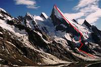
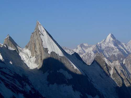
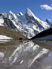
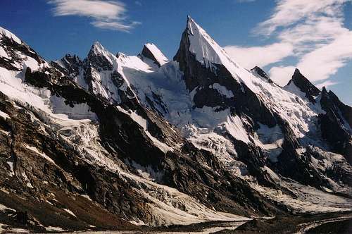
Laila Peak (also spelt Leyla or Lila Peak) is one of the most beautiful mountains in Pakistan - if not the world with its summit forming a perfect needle shape. The peak is synonymous with its west face which drops down the mountains at almost uniform gradient forming a giant ramp Its northern and eastern sides consist of contrasting steep granite. The mountain is located east of the Gondogoro valley and west of the Chogolisa valley in the Masherbrum Mountains of Baltistan. Most people have set eyes on the peak after crossing the Gondogoro La from Concordia and K2 base camp.
Like many peaks of this height in the Karakoram climbed in the 80s and 90s, the first ascents were done illegally without the relevant permits. Climbs therefore received limited initial acknowledgement. The first ascent was by a four man British team including Simon Yates, Sean Smith and Mark Miller who climbed the peak in 1987 via the west face from the Gondogoro Glacier. This was Simon Yates’ first big climb since the epic on Siula Grande in 1985. While technically being an ‘unofficial’ climb it became as official as any ‘official’ climb when Simon Yates dedicated a chapter of his biographical book “The Flame of Adventure” on the climb. This included a number of excellent photos of the climb. The party went on to make a first ascent of the nearby Nemeka (6400m).
The Italian Route
During the early 90’s a German team climbed the mountain by the same route with a Swiss team also summiting in 1993. These were also done illegally. The first ‘official’ ascent wasn’t until 1997 by an Italian party. Fabio Iacchini and Paolo Cavagnetto initially climbed the peak with Camillo Della Vedova, Giovanni Ongaro and Guido Ruggeri summiting the following day. On reaching the top the Italians discovered a gas cartridge with the names of the four British climbers, who had climbed the mountain a decade earlier, scratched into it. The line that the Italians climbed was however slightly harder following the west face-north ridge as opposed to the west face-southern slopes. The team had tried to climb the mountain the previous year but had been thwarted by poor snow conditions.
All the above climbs were done in an Alpine style. The mountain can be climbed by a strong party in a single day from an advanced base camp on the east side of the Gondogoro glacier. With approximately 1500m ascent many people will choose to bivi on route then summit and descend on the second day. Climbing is mid-grade with an inclination of no more than 55 degrees. The lower section of the climb is mixed giving way progressively more ice towards the summit. The easy, nearby Gondogoro Peak (5650m) can be used for acclimatisation if so desired. I'm hoping to try this peak myself at some point in the next few years so PM/email me if interested!
Laila peak has also been skied down by Fredrik Ericsson and Jörgen Aamot. This was a first ski descent on the mountain. The pair did not actually summit the mountain stopping 120 to 140m short. Icy conditions at the very top would have been suicidal to ski down. Having descended Laila they ascended and skied down Gasherbrum II.
 Laila Peak
Red Tape
Laila Peak from close to Xhuspang Camp
No permit or liaison officer is currently required to climb the mountain because it is less than 6500m. Pakistan’s Ministry of Tourism raised the threshold height for permit requirements from 6000m to 6500m subsequent to 9/11 in the hope of attracting climbers but to Pakistan again. All ascents described in the overview therefore required climbing permits. There will be no change to the current policy for 2009.
The mountain falls in a ‘restricted zone’. Restricted zones are areas relatively close to border areas (ie India, China and Afghanistan). The village of Hushe, which is the gateway to the mountain, is in an open area as is the Masherbrum valley to the West of Laila. The Gondogoro and Chogolisa valleys are however restricted making the peak significantly more expensive to climb. In order to visit these valleys a permit must be purchased from the Ministry of Tourism ($50 per person), a licensed guide hired, and a personal accident insurance policy taken out for the guide(s) and porters. The guide is required for the duration even though he will do little once at base. There are climbing guides in Pakistan however few are any good by Western standards (this is probably the wrong mountain to be climbing anyway if you require a guided ascent). One member must attend a mandatory briefing and debriefing at the Ministry of Tourism in Islamabad and also a debriefing. Some people skip the debriefing although this reflects badly upon the associated guide who relies upon the Ministry of Tourism for issue of their licence. Most people use a trekking company in Pakistan who will provide a licensed guide, deal with bureaucracies and make all arrangements.
The above requirements are only for foreigners. Pakistanis who are not from the Northern Areas can easily visit this area without a permit. Beyond Hushe there are no check posts, which is why parties in the past have found it easy to enter the valley without the appropriate paperwork.
Pay to Climb One Laila Peak, Get Two Free!

West face from the Gondogoro Valley
There are actually three Laila peaks in Pakistan to create confusion. ‘Laila’ means ‘dearest or most love one’ in local language. The highest is located on the south side of the Chogo Lungma Glacier in the Haramosh Mountains. It’s not far from Spantik, which is popular with commercial expeditions. The mountain is hard to climb and because it is 6986m a permit is required to climb it (see ‘Red Tape’ Section on the SP Karakoram page that I am currently building). The smallest Laila is on the south side of the Rupal Valley in the far western Himalaya. The peak is only 5971m but still a nice peak to climb. It requires no climbing permit as is the case with the Laila Peak featured on this page. All the Lailas have been climbed, but not surprisingly, no single person has climbed them all.
Getting There

The Skardu River
The peak has a remote setting in the heart of the Central Karakoram but is relatively easy to reach from the village of Hushe which is itself connected by road to Skardu. Passenger Jeeps travel between Skardu and Hushe in around eight hours. Because the Gondogoro and Chogolisa valleys are restricted most people climbing this peak will travel by private Jeep between Skardu and Hushe with a trekking company. This is usually inevitable anyway as passenger Jeeps are not usually equipped to carry an expedition load in addition to other passengers’ baggage.
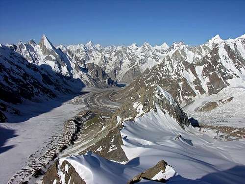
From the village of Hushe the mountain can be reached in around two days however unacclimatised parties may wish to take longer in order to gain altitude at a slower rate (base camp is at 4680m while Hushe is only at 3050m). The way is easy to navigate since numerous trekking parties descend the valley as a finale to the K2 trek. Porters are easy to arrange in Hushe. The route initially follows the true left bank of the Hushe River north. After a couple of hours the trail bares northeast following the combined Gondogoro and Tsarak rivers. Shaishcho (see ‘Camping and Accommodation’ section below) is reached an hour or so later. East of here is the Charakusa (or Tsarak Tsa) valley which is renowned for its exceptional rock climbing. From Shaishcho the Gondogoro valley begins with the trail initially climbing steeply. The Gondogoro Glacier can be followed along its true left bank for much of the way however needs to be traversed to its true right higher up. The glacier is easy enough to cross for any mountaineer with glacier experience.
 The Gondogoro Glacier |
 The Gondogoro Glacier |
 The Gondogoro Glacier |
The mountain can also be reached via the Gondogoro La. This would be an expensive, time consuming way to reach the mountain however a fantastic trek via the Baltoro glacier and Concordia. Trekking groups crossing the Gondogoro La from Concordia usually only take a few porters over the pass with respect to the number who leaves Askole at the start of the trek since most of the food has been depleted by then. With Laila Peak added to the itinerary significantly more porters will be required to cross the pass to the Gondogoro valley increasing overall cost. Corax has further information about crossing the Pass on his Gasherbrum I page. It’s not very hard but it has some of the best views from any pass in Pakistan.
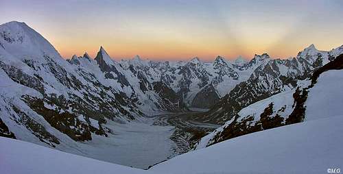 Laila Peak at sunrise (viewed from Gondogoro La)
 Laila Peak from Gondogoro Peak (5700m)
Skardu, which is the gateway to Baltistan, is easy to reach by bus or plane. There are daily flights from Islamabad to Skardu with PIA however it’s best to book in advance where possible. Flights are not expensive and it is recommended to fly in at least one direction as the road between Gilgit and Skardu is not overly exciting or varied and the bus the Gilgit to Rawalpindi is a rough overnight trip. Lights sometimes get cancelled due to bad weather but not as regularly as Islamabad to Gilgit flights.
Buses also run daily between Gilgit and Skardu leaving from the main bus station. For the hardcore there is the Skardu to Rawalpindi bus, which takes about 24 hours. Sometimes the Gilgit-Skardu or/and the Gilgit-Rawalpindi roads block due to landslides so keep abreast of current road conditions if you have a forthcoming international flight.
Camping and Accomodation

Hushe Village

Xhuspang Camp (4680m)
There is plenty of Accommodation in Skardu for all budgets. I don't like to hang around the town longer than I have to though as it's pretty drab.
Hushe also has a number of places to stay due to the relatively large volume of trekkers passing through. Many expeditions choose to camp on the outskirts of the village to the north where the is a Rs20 camping fee.
A number of camping spots can be found on route to base camp. These include Shaishcho (3330m), Atosar (3750m), Gondogoro Camp (3950m) and Daltsampa (4300m). All are free with the exception of Shaishcho which is a commercial campsite. Campsites north of Shaishcho are not particularly pleasant due to smelling of human faeces!
The camping spot of Xhuspang near the head of the valley is a great place for base camp with fantastic views of Laila (most photos of the mountain are taken from here). The camping area is large, however since 90% of permits issued for restricted areas are for the K2 trek the campsite can be fairly busy on some days when a lot of people cross the Gondogoro La.
An advanced base camp can easily be placed on the Eastern side of the valley directly below the mountain.
A bivi bag is sufficient for higher camps as nights are relatively mild in the Karakoram (see ‘climbing conditions’ section below).
Climbing Conditions
The main problem with climbing peaks such as this in the Karakoram is that snow sometimes does not freeze at night. As many people will know climbing 55 degree soft snow is miserable and exhausting. Many expeditions to the Karakoram have been forced to give up due to snow conditions. Patience to wait for the right climbing conditions is important. A certain amount of luck is required as with any big mountain.
Snowfall can occur at any time although it tends to be quite a mild affair during the summer months. At high altitudes unstable snow pack can still quickly build up after an extended period of bad weather. Slab avalanche risk may also obviously be present on the west face if the snow is not consolidated properly.
Temperatures are warmer during the climbing season compared to other ranges that I have visited such as the Nepalese Himalaya, Tian Shan or even the Caucasus making it feasible to pack lighter. I use a bivi bag on peaks of this altitude without sleepless nights.
 Laila Peak from Xhuspang camp
When To Climb
The climbing season is generally from June until September. August is the most popular month for climbing but not always the best. Hardly anybody climbs in the Karakoram in winter due to the high level of precipitation. A peak such as this would likely be a death trap via the west face.
Maps

Approaching Xhuspang camp
The Swiss map is the most commonly used in Pakistan despite errors and a scale of 1:250,000. No camp sites are labelled except Shaishcho which is labelled as Chospah. The route up the Gondogoro Glacier is also wrong. The map shows a long traverse towards the Masherbrum La (5364m) whereas in fact the route follows the true left hand side of the glacier for much of the way crossing between Daltsampa and Xhuspang. Sheet 1 and 2 are sold together and cover the whole of the Karakoram including the Indian and Chinese areas. The Lonely Planet ‘Trekking in the Karakoram & Hindukush’ guidebook is actually more helpful than the map for this valley purely for its route description.
The Russian series of maps are without a doubt the best. They are available in 1:50,000 and 1:100,000 scale although I cannot tell you what specific sheet covers this mountain. The maps are not cheap! The 1:50,000 maps usually cost around $75 and the 1:100,000 around $50.
There is also a fairly new Japanese set of maps for the Karakoram although they are hard to come by. The map claims to have surveyed every peak however I cannot pass comment on its quality since I have not seen it (I tried to obtain a copy last summer but failed). Laila Peak is surveyed as 6096m.
Don’t waste money on the Leomann maps as they are poor quality (although at first glance may look similar to the Swiss maps).
Books
Simon Yates' first book 'The flame of Adventure' is the book to buy if you are planning to climb Laila Peak as there is a chapter dedicated to the first ascent of the mountain by the author. The climbs in Pakistan are by far the best parts of the book. It's quite easy to obtain at the moment but, as with all climbing literature, it may not be so forever.
Food & Provisions
You can buy gas cartridges in Skardu in the bazaar. This is ex-expedition gear. Prices aren't a bargain and I try and use a multifuel stove for all but the climb itself. Kerosene is dirt cheap and widely available - even in villages. It's very dirty however and you'll need a decent stove such as an MSR Dragonfly or XGK. Cheap multifuel stoves will block quickly and then you will go hungry!
All food can be bought in Skardu and I've never found the need to waste valuable airplane baggage on imported food. Gilgit also has plenty of shops to buy food if you plan on pasing through Skardu quickly.
External Links
2005 Laila Peak Ski Expedition Report
The quoted altitudes on this page are wildly wrong. You may also want to take a look at Frederick Ericsson's Home Page..
The Wilkopedia page is almost an exact replica of this page prior to me adopting it and contains the same errors. The chicken or the egg....?!
BigLee - Mar 14, 2006 1:41 pm - Hasn't voted
First summit of Laila PeakThe first ascent of Laila Peak (aka Leyla Peak) was made by Simon Yates, Mark Miller and Sean Smith in the late 1980's. They reckoned the mountain's height to be around 6300m which is the height generally accepted by most. They also climbed nearby Nemeka (6400m). For further reading on this expedition consider buying 'The Flame of Adventure', written by Simon Yates.
aaporik - Mar 14, 2006 5:42 pm - Hasn't voted
Re: First summit of Laila PeakDear BigLee, Thanks for the information. It is hard to buy such unique books in Pakistan. But any how I will try to find it in Pakistan. Simon Yates and Mark Miller and both my close friends. I have been with Mark Miller several time and I was in touch with her girl friend after his death in Nepal. He was a wounderful guy and great climber. You remind me old memories of mine. Thanks for the info I will soon update this.
Corax - Jan 3, 2007 8:10 pm - Voted 10/10
LailaWow! The page is very nice now. Fredrik and Jörgen were about 120-140m from the summit when they encountered really bad snow and ice conditions. Fredrik told me, they would have had problems reaching the summit at all and to ski down the top part had been suicidal. They therefore turned back close to the summit, skied down and went to Gasherbrum II instead. They summited and skied GII successfully.
BigLee - Jan 3, 2007 9:35 pm - Hasn't voted
Re: LailaThanks. Updated the page. Thought that no one climbed GII in 2005 but was wrong.
BigLee - Feb 3, 2007 6:27 pm - Hasn't voted
Re: LailaHmmmm... Nope I'm thinking of K2 not GII that didn't get climbed in 2005.
Afzal - Jul 22, 2007 6:11 am - Voted 10/10
Elevation: 20341 ft / 6200 mThe actual elevation of Laila Peak is : 20000 ft / 6096 m.
BigLee - Jul 22, 2007 7:18 am - Hasn't voted
Re: Elevation: 20341 ft / 6200 mThe British quartet measured the peak to be around 6300m, the Italians who climbed the peak in '96 measured it to be 6200m. I've heard the figure of 6096m quoted as well but I'm not sure of the original source. I've quoted the Italian figure as it's in the middle of the readings.
Afzal - Jan 17, 2009 10:55 am - Voted 10/10
De-Briefing!You have mentioned that "One member must attend a mandatory briefing and debriefing at the Ministry of Tourism in Islamabad although many skip the debriefing". I am a tour operator and I know that no body can leave the Pakistan without de-briefing at Ministry of Tourism Islamabad. In some case there may be some relaxation (not for all) to those trekkers who have to go back their countries through Khunjerab pass via China, subject to prior approval from Ministry of Tourism, Islamabad on the event of briefing. The briefing & de-briefing are mandatory and all trekker have to attend the mandatory briefing and de-briefing.
BigLee - Jan 18, 2009 5:54 pm - Hasn't voted
Re: De-Briefing!No problem, I'll update when I get a moment as I know that by not attending the briefing it reflects badly on the respective guide(s).
Afzal - Jan 19, 2009 6:11 am - Voted 10/10
Re: De-Briefing!Thanks.
richardh - Feb 26, 2013 7:27 am - Voted 9/10
winter ascentJosé Fernandez and Alex Txikon have made a winter ascent of Laila Peak - see http://www.himalayamasala.com/ascents/laila-peak-west-face-2013 BTW, 6096m is now being quoted fairly widely as if it's the accepted height, but on Google Earth it looks as it it's 6200m or even a bit more.