
|
|
Mountain/Rock |
|---|---|
|
|
35.89503°N / 75.86248°E |
|
|
Mountaineering |
|
|
Summer |
|
|
21181 ft / 6456 m |
|
|
Overview
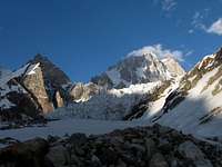
Latok IV is last summit of Latok Group. It lies on end of Baintha Lukpar Glacier. It has two summits - north (northwest) 6456 m is main summit and south (southeast) 6450 m. Main summit is formed by ridge with four summits.
North summit was climbed just once in 1980 by Japan team. Motomu Ohmiya and Koji Okano made it to the top through central gully in southwest face in three days. On descent they fell 150 feet to crevasse. Okano broke a rib and Ohmiya his right ankle. After four days of waiting for help in the bottom of crevasse, Ohmiya left Okano (who could not move) and dug a tunel out to freedom. It took him five hours to make 12 foot long tunnel. After two days he made it to camp, where was his friends. Okano was rescued eight days after fall (with help of British expedition).
South summit was climbed twice, at first by Motomu Ohmiya (in 1980 before fall) and at second by super fast ascent made by Alexander and Thomas Hubers.
Ascents

Main (north) summit (6456 m)
- 1980 Southwest face - Japanese Route - M. Ohmiya, K. Okano.
- 2009 Southwest face - Czech Route - TD, 800m, 5+, 70° - O. Mandula, J. Pliska (climbed just to summit ridge).
South summit (6450 m)
- 1980 Southwest face - Japanese Route - M. Ohmiya.
- 1999 Southwest face - Japanese Route - A. and T. Huber.
Getting There
From Islamabad to Skardu by air (1 h) or KKH (about 24 h). Then by jeep to last village in Braldu Valley - Askole (6 - 8 h). Here starts trek through Biafo - Hispar Glaciers. In place called "Baintha" (it is just before junction of Biafo a Baintha Lukpar glaciers) turn right on moraine of Baintha Lukpar Glacier. From Askole it takes two or three days.Red Tape
Biafo Glacier (and Baintha Lukpar) is in Open Zone (and Latok IV is below 6500 m). You don't need guide or climbing permit. You need just trekking permit (or something like this...) to cross military checkpoint in Dasu (Daso) on the half way form Skardu to Askole.Camping
There are two main possibilities to make a BC. First is on grassy spot on right (on way up) moraine of Baintha Lukpar Glacier, which is to two hours from „Baintha“. Someone calls it "Spantik" (green) BC. But take care in area is another two "Spantik" BC :-). Or you can make BC on ice later on Baintha Lukpar Glacier.Czech Route

Firs ascent report
We climbed it through four days in July 2009. Our BC was in (first) "Baintha" and it took 4-5 hours to get to ABC on Baintha Lukpar Glacier, where we pitch a tent. Next day we cross heavily crevassed glacier under the southwest face and made a bivy (without tent) on small ridge.
Climbing started in 3 AM next morning. First 200 m was easy 50° snow, which we climbed simultaneously. Then it getting steeper (between 60-70°) and icy and we continued roped up. Sometimes we reached places with very deep snow with bad protection possibilities. Last 100 m (3 pitches) climbing was getting mixed with variable rock quality and some snow-drifts which we had to dig. At 2 PM we have been on summit ridge (50-100 m of easy climbing form summit) and have not continued to summit because of bad weather. To 9 PM we made rappel to bivy and next day walked to BC.
Description
From ABC to high camp (about 5600 m) under the southwest face go mostly on right site to avoid crevasses (depends on conditions). Good place for safe camping is on end of plateau on small ridge, where route starts.
Entire route is in gully. First rocks (after 200 – 300 m) avoid from left. Then all the way in more or les in center. 100 m before top the overhanging chimney blocks the way up. Avoid
it on rocks on right side (key pitch). Then one pitch with 5m 90° ice chimney and last very nice mixed pitch to summit ridge. From there it looks easy (take care on cornices) 50 – 100m to summit (one from 4 – main???)
 |
 |
 |
 |
 |
 |
 |
External Links
AAJ 1981 - First ascet of Latok IV (.pdf)AAJ 2000 - Huber brothers ascent (.pdf)
AAJ 2007 - Latok Groupe clarification (.pdf)