
|
|
Mountain/Rock |
|---|---|
|
|
36.14345°N / 74.48936°E |
|
|
Nagar |
|
|
Mountaineering |
|
|
Summer |
|
|
25551 ft / 7788 m |
|
|
Overview

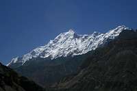
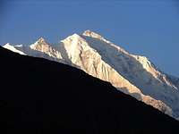
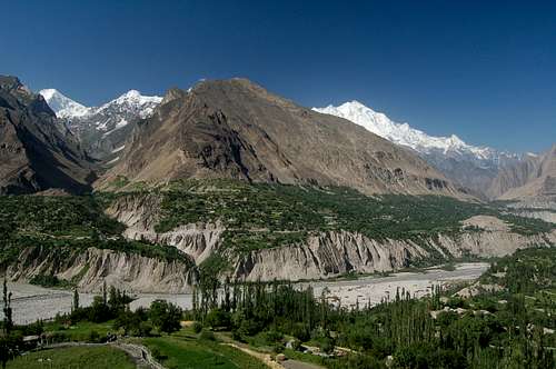
North Face of Rakaposhi (7788m) from the KKH
Eric Shipton called the Hunza vallay "the ultimate manifestation of mountain grandeur". Rakaposhi is valley's most famous peak. The huge massif dominates the skyline for a vast stretches of the Karakoram highway, first seen North of Aliabad yet still visible as far south as Gilgit. The peak is located in the Rakaposhi-Haramosh range which forms the south-western corner of the Karakoram and is part of the Lesser Karakoram. The mountain is extrememly broad measuring almost 20km from East to West. It is the only peak on Earth that drops directly, uninterrupted, for almost 6000m from the summit to the base. Besides the highest peak of the Rakaposhi massif is Rakaposhi East (7010m). The peak also holds significant value to Geologists as it is the prow of the Eurasian land mass with Nanga Parbat representing the prow of the Indian land mass.
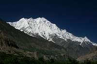
Rakaposhi from the Karakoram Highway
In local Burushaski language Rakaposhi means "Shining Wall" (not to be confused with Gasherbrum I which also means "Shining Wall" in the local Balti language). The peak is also known as Rakapushi, Pk 27/42L and Dumani (Mother of Mist). Due to the mountain's prominent position in the centre of the Hunza valley many have considered climbing the peak but relatively few have attempted the summit. For this reason the mountains maintains a certain enigma for many who visit the area. 2007 is an excellent time to attempt Rakaposhi though as royalties for the peak are 10% the normal rate and 5% the normal rate if attempted during winter (see red tape section). The mountain is not easy to climb from in any direction. Western routes are very long, northern routes are very high and technically difficult, and southern and eastern routes are plain dangerous due to extreme avalanche risk.
After six failed expeditions the peak was first climbed by a "British-Pakistani forces Himalayan Expedition" in 1958 via the SW Spur. In reality this was a British expedition aided by the help of all available high-altitude porters in the Hunza region. Six camps were required to get within range of the summit and climbing was impeded by incessant snowfalls, avalanches and blizzards. On summit day a violent blizzard was blowing, half-flattening Captain Michael Banks and Lieutenant Tom Patey's tiny two man tent and driving drifting snow high into the air. Despite the severe conditions Banks and Patey, two of the seven climbers in the expedition made a bid for the summit, thirty-six days after setting up base camp. In poor conditions both reached the summit five hours later without oxygen. The cold weather had taken its effect though. Banks had frost-bitten feet whilst Patey had frost-bitten hands but fortunately it was not severe. Not surprisingly they did not linger and descended quickly back to their tent and returned to base camp three days later. It was not until 1979 that the mountain was again climbed. To date there have been eight ascents via three routes with all climbing done in a siege style bar one (Canadian team, North Ridge, 1984).
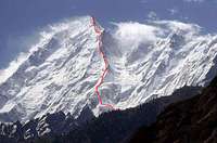
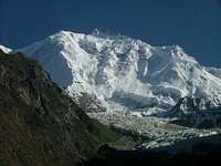
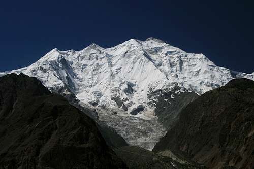 North Face of Rakaposhi
Routes
Considering the mountain's bulk it is slightly surprising that there are only three completed routes to the summit.
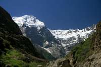
NW View of Rakaposhi
SW Spur
This is considered the easiest route and is consequently the most popular. From between the Kunti glacier the route ascends via the Monk's Head (6340m) where the SW spur connects with the SW ridge. The steepest section is a 600m 50-60° ice slope leading to the Monks Head. The route is long, but not exceedingly technical. There are some tricky gendarmes (rock pinnacles) however the route is generally straight-forward. It was first attempted in 1947 by Bill Tilman and his party however they only managed to reach a point around 6200m. In 1954 a Cambridge University team bettered this by reaching the Monk's Head but were unable to proceed beyond this point. A third attempt in 1956 by a British-American expedition also failed to reach the summit. Having reached 7,163m above the Kunti glacier bad weather among other factors bought their climbing to a close. The route was finally climbed by Banks and Patey in 1958 as previously described. Subsequent ascents followed in 1983, and in 1997 by an Iranian team.
NW Ridge
Section of the NW Ridge from the KKHThis 10km long ridge ascends from Biro glacier between the Nun's Head and Secord Peak to the summit and is more technically difficult than the SW Spur but easier than the routes on the north face. Above base camp there are a number of gendarmes on the ridge however these can be bypassed on the right. Above these the route climbs below the top of the Nun's head then descends 60m onto a broad snow terrace below Rakaposhi's main summit pyramid. This is traversed to a col from where the summit can be ascended to via the Southwest Spur. The main difficulties are at the start of the ridge at 4900m. M Vyvyan and R Campbella, the first to attempt Rakaposhi, climbed the north-western peak of the mountain via this route which they consequently named Secord Peak (5900m). Whilst they declared that the route was long it was achievable by a strong party.
The route was subsequently attempted by Bill Tilman's party and by the Cambridge University team both resulting in failure to reach the summit. The route was first climbed 21 years after Banks and Patey in 1979 by a Polish-Pakistani expedition. The Polish-Pakistani expedition fixed around 3000m of rope from 4900m upwards. Ryszard Kowalewski, Lieutenant M. Sher Khan and Tadeusz Piotrowski initially went to the summit with Andrzej Bielun, Jacek Gronczewski and Jerry Tillak summiting the following day. Three days later, supported by no one above camp II at 6200m Anna Czerwinska and Krystyna Palmowska, fought their way to the summit through wind and drifting snow unroped in order to climb quicker. This was the second highest "ladies only" ascent at the time after Halina Kruger and Anna Okopinska who climbed Gasherbrum II to 1975.
The route was repeated in 1987 by a Netherlands team consisting of Dries Nijsen (leader), Tom van den Boogaard, Rudolf de Koning and Mathieu van Rijswick. They initially climbed a shorter route to the right of the 1964 attempt to get to the ridge at 6000m, where they joined the Polish route of 1979. Initial good weather changed for the worse midway through the expedition after Camp III was established at 6350m. Camp I at 4800m was destroyed by an ice avalanche and Camp II disappeared under deep snow. Nijsen also developed cerebral oedema around this time. Eleven days after first establishing the third camp it was again reached. Van Rijswick lost his pack and Nijsen suffered continuous nausea and it was left to Van de Boogaard and de Koning to continue to the summit via by the same way as the Poles. A Colombian team ascended this route in 1995. To date there have only been three successful ascents.
North Ridge (or North Spur)
The North (Japanese) Ridge
Ascends between the Ghulmet and Pisan glaciers around 6000m. An initial couloir climbs to the ridge at 5500m above the Pisan Glacier avoiding an initial section of cornices and rock steps. The ridge is long but relatively safe from the objective dangers either side. Karl Herrligkoffer lead two expeditions to attempt the north spur but both failed due to strategic difficulties caused by the complexities of ascending this route. Eiho Ohtani lead a successful Japanese team to the summit fixing a staggering 5000m of rope along the way. A 150m rock band between 6400m and 7000m was bypassed by means of a couloir and, having climbed a 45m ice step below 7300m, Ohtani and Matsushi Yamashita bivouacked at 7600m. The final section of the ridge involved a difficult rock band rated UIAA VI, 5.8, A2 above which the summit was traversed to. The North Ridge is sometimes referred to as the Japanese Spur.
A Canadian expedition in 1984 consisting of Barry Blanchard, David Cheesmond, Kevin Doyle, Tim Friesen and Gregg Cronn were the second group to summit via this route and did so in a better semi-Alpine "Capsule" style. After an initial three week siege attempt failed 250m short due to heavy snowfall high on the route, a second attempt consisting of Barry Blanchard, Dave Cheesman, and Kevin Doyle then climbed the route in 7 days. All three were knocked unconscious at least twice by lightning, needing to be revived by the other two. The Canadians called this route the 'Cassin Ridge of the Karakoram'. To date this is the most impressive ascent of the mountain.
East Ridge
Rakaposhi from Aliabad on the KKH
The East ridge climbs to the summit of Rakaposhi East (7010m) from where the summit ridge needs to be traversed west in order to reach the main summit. It received three attempts in the 80s but were without success and the route to Rakaposhi's main summit via this route remains unclimbed. The first attempt was by an Austrian expedition led by Edi Koblmuller in 1985. They reached the East summit (7010m) but the main problems were above and the team went no further. A Japanese team from Maiji University subsequently also tried to seige the route two years later climbing beyond the East summit to c.7300m but the ridge was too difficult beyond. The third attempt by a Norwegian expedition consisting of Arnfried Braun, Ulrich Calmbach, Hans Jakobi, Felix Hass and Fred Husøy tried to climb Alpine-style but only got to 5100m before being driven back down due to bad weather. A second attempt was also defeated by bad weather. This time c.6550m was reached. The route climbs rock to 5350m with a crux 5.10, A2. Beyond is mostly ice climbing with difficult mixed climbing between 6050m and 6400m.
NW Spur
NW Spur - Unclimbed
The NW spur is the longest spur in the world, rising nearly 4000m over a length of 7km between the Masot and Gulmit glaciers. It remains unclimbed today and is one of the Karakoram's big unclimbed objectives. The first 3000m involves mixed climbing with the need for aid climbing at some points. This is followed by a flatter section but, between it and the summit raised the most difficult part: a sheer vertical rock wall, 700m high.
The first attempt on this route was in August 2001 by a French team consisting of Manu Pellissier, Manu Guy, Ildi Kiss, Isabelle Carrier and Jawed Ali. Following acclimatisation on nearby peaks and sustained bad weather the attempt was made in an Alpine style approaching from the Gulmit Glacier. Due to poor conditions the team made little progress and the objective was switched to the North Spur instead. Following more bad weather this route also had to be abandoned.
In 2005 a primarily Italian team consisting of Alberto Peruffo (leader), Renzo Corona, Ivo Ferrari, Michele Romio, Marco Scarso and American Carlos Buhler made the second attempt. The team tried to approach from the Masot Glacier but discovered that a surprisingly large glacial retreat over the last four years had made it impossible to find a feasible libe through the maze of seracs guarding access to the foot of the Spur. They eventually abandoned their attempt. A trip report is available here.
There is further information about the route including some good topos here
Other Routes
The East (Bagrot), South and North face (west of the North Spur) are all unattempted with the exception of the East face in 2000. All have considerable objective dangers with dangerous seracs and high avalanche risk.
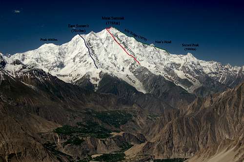 Routes on Rakaposhi's North Face
Summary of Rakaposhi's Climbing History
|
Year |
Team/Country |
Route |
Summit |
|
1938 |
M Vyvyan & R Campbella |
NW Ridge |
N |
|
1947 |
Bill Tilman |
SW Spur & NW Ridge |
N |
|
1954 |
Cambridge University |
SW Spur & NW Ridge |
N |
|
1956 |
British-American Team |
SW Spur |
N |
|
1958 |
Mike Banks & Tom Patey |
SW Spur |
Y |
|
1973 |
Karl Herrligkoffer Expedition |
N Ridge |
N |
|
1975 |
Karl Herrligkoffer Expedition |
N Ridge |
N |
|
1979 |
Polish-Pakistani |
NW Ridge |
Y |
|
1979 |
Eiho Ohtani & Matsushi Yamashita |
N Ridge |
Y |
|
1981 |
Spanish Team |
SW Spur |
N |
|
1983 |
Belgian Team |
SE Spur |
Y |
|
1984 |
Canadian Expedition |
N Ridge |
Y |
|
1984 |
Slovenian Team |
N Face |
N |
|
1985 |
Austrian Expedition led by Edi Koblmuller |
E Ridge |
N* |
|
1986 |
Japanese Team |
NW Ridge |
N |
|
1986 |
Dutch Team |
NW Ridge |
Y |
|
1987 |
Slovenian Team |
N Ridge |
N |
|
1987 |
Japanese Meiji University |
E Ridge |
N |
|
1987 |
German Team |
E Ridge |
N |
|
1991 |
Condor Adventures |
NW Ridge |
N |
|
1996 |
Anibal Pineda |
NW Ridge |
Y |
|
1997 |
Iranian Team |
SE Spur |
Y |
|
2000 |
Details to follow |
E Face |
N |
|
2001 |
French-Pakistani Team |
NW Spur |
N |
|
2005 |
Italian-French-American Team |
NW Spur |
N |
Red = first ascent
Blue = First ascent via new route
Bold = Successful ascent via previously climbed route
* First ascent of Rakaposhi East (7010m)
More about the 1984 Canadian Ascent of the North Ridge
Kevin Doyle, a successful member of the 1984 Canadian team who climbed the North Ridge, sent me this account of the climb.
...the first attempt with 5 climbers, including Tim Friesen and Gregg Cronn, failed due to heavy snowfall high on the face. I was avalanched off on lead just below what became our high camp, losing my pack and all my personal gear including my sleeping bag and down jacket, and most of our stove fuel in the process. I was caught by my team-mates on the climbing rope.We remained on the mountain, and mounted a summit attempt from a camp above this point. I slept in between 2 other climbers, in only my clothes, and 2 vapour barrier bags. The following day, the storm had cleared somewhat, the upper face was barely navigable, and extremely steep, with 70-85 degree snow over ice steps and snow beneath. Probably 24-28 inches of new snow. After 3-4 pitches into this extremely unstable and dangerous section of the face, we retreated using 2-100 meter long 9 mm ropes to rappel back down. Lower on the route, we dropped down a steep couloir (skier's left, climber's right), which deposited us on the upper glacier just (climber's) left of what we called "the cannon", an inverted cave structure which belched out ice avalanches every few minutes. We waited until a couple of big discharges, then ran unroped across this section to avoid being hit. We repeated this descent after our successful summit attempt about 10 days later, with the 3 of us. On the summit day, all 3 of us were knocked unconscious at least 2 times each by lightning, needing to be revived by the other 2. In my case, it was 3 times. I cannot speak accurately for the others. On arrival at the summit, we were unable to physically touch the top rocks, because each attempt met with a ground current discharge from fast-moving cloud, knocking the climber in each case to the ground. After several attempts, we gave up trying to stand on the top rocks. Therefore we were 3-5 feet below the top at our highest "tag point".
Getting There
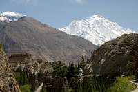
Hunza valley viewed from Karimabad
Travel to the Northern Areas
Islamabad is the nearest international hub with flights arriving from around the world. Gilgit is the largest town in the Northern Areas served by regular transport from the north and south.
Domestic flights
PIA fly daily between Islamabad and Gilgit and tickets can either be booked via their ticket offices or via their website. One-way fairs are currently Rs1590 with little discount for return trips. During bad weather planes may be grounded at short notice. There are also daily flights to Skardu which operate a higher percentage of the time.
Buses
Buses run daily between Rawalpindi's Pir Wadhai bus station and Gilgit, and vice versa. Buses leave throughout the afternoon and arrive mid-morning next day. Book tickets in advance if possible to avoid a bone jarring, sleepless ride on the back seat (seat sell from the front backwards). Travel along the KKH is anything but predictable and landslides, mudslides, rock fall and even avalanches can sever it for hours, days or weeks at a time. NATCO and Masherbrum both run buses daily with a limited number of seats available at student discount.
Rakaposhi from above Karimabad
The Northern Areas can also be reached from China with the trip from Kashgar to Sost taking 2 nights with an overnight stop in Tashkurgan. Hi-Ace vans travel between Sost and Gilgit throughout the day leaving as soon as they are full. There is now a direct bus between Tashkurgan and Gilgit, however, if travelling from China, it is better to buy a ticket to Sost only then take local transport to Gilgit as the international bus sits in the customs yard at Sost for a couple of hours while luggage is checked before continuing to Gilgit. The Chinese side of the KKH (called the "Sino-Pakistani Highway" by the Chinese" has been a disaster area for the last couple of years due to road works. Rather than repair small sections of road at a time as most countries do, the Chinese labour force likes to dig up great stretches. The journey to the border therefore means a lot of off-road travel. The road works has unfortunately caused significant soil erosion either side of the road that will be irreversible.
Vehicles leave Chitral (in the Hindukush) for Gilgit at least once a week, the journey taking about 16 hours by Land Cruiser. The road crosses the Shandur Pass (3,734m/12,251ft), which is passable for an even shorter period than the Lowari Pass. Otherwise Private Landcruisers can be hired for the journey which allows you to plan your own itinerary.
Reaching the Base Camps
Due to the size of Rakoposhi's massif it can be approached in a number of ways.
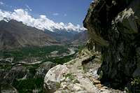
Jaglot is a short distance from the KKH which is frequently serves by Hi-ACE vans travelling between Gilgit and Sost. The Jeep track to Jaglot is hard to spot but located a short distance south of Jaglot Goor, a small village bazaar where vehicles break their journey. From Jaglot the base camps on the Biro and Kunti glaciers are a couple of days west following the Jaglot River. From here the NW ridge and SW spur can be attempted via advanced base camps on the Biro and Kunto glaciers respectively.
North Face of Rakaposhi from Minapin village. North Ridge to left of photo
The Masot, Gulmit, Pisan and Minapin glaciers below the north side of the mountain are easily accessed due to their relative proximity with the KKH. The Pisan and Minapin glaciers can be accessed from the village of Minapin which is served by public transport from Gilgit. Failing this take a HI-ACE minivan as far as the turning on the KKH and hitch/walk from there. Expeditions can easily hire Jeeps in either Karimabad, Aliabad or Gilgit.
To reach the Eastern (Bagrot) Face's base camp take public transport to Chirah. Gilgit Chirah jeeps depart from Gilgit's Garhi Bagh (between NLI Chowk and the GPO) around midday, returning early next morning. Special hires are easy to organise in Gilgit. The journey takes about 2 hours. Don't take the bus to Jalalabad as there are no connections to Bagrot. Chirah it is a 12-14 hour walk to base camp, which is best divided into 2 days. Spend the first night at Bayabari, a grassy area 2 hours from Chirah at the SE aspect of the Hinarche glacier. Next day start early and follow the Eastern side of the glacier to reach Bagrot glacier in 10-12 hours.
Red Tape
Royalty Fees
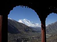
Rakaposhi from Baltit Fort in Karimabad
The Ministry of Tourism has decided to maintain the 10% reduction in mountaineering royalty fees for peaks above 6500m in the Gilgit region (excluding Spantik) during 2009 in an attempt to attract more expeditions to the Karakoram.
Royalties per expedition are based on a party of 7. Persons additional to this number will be subject to an additional royalty fee. Current royalties are listed below.
Note: These rates are only for the Gilgit region of the Karakoram which includes Hunza and Gojal (Upper Hunza).
No Liaison Officer is currently required for the Gilgit region!
This makes the mountain very cheap to climb since it is not in a restricted zone.
Royalties for other areas of the Karakoram are 50% the normal rate and a liaison officer is still required. See the Karakoram page.
| Elevation | Normal Fee | Fee for 2009 | ||
| Expedition Royalty | Additional royalty per person | Expedition Royalty | Additional royalty per person | |
| 7501 - 8000m | $4000 | $500 | $400 | $50 |
| 7001 - 7500m | $2500 | $400 | $250 | $40 |
| 6501 - 7000m | $1400 | $200 | $140 | $20 |
| Up to 6500m | $1400 | $200 | No fee | No fee |
Peak royalties are only 5% the normal rate for a winter attempt although this is only for the masocists. Anybody considering a winter climb should read the information in the section directly below.
Visas
A valid visa is required. Visas are NOT issued at the airport and must be obtained prior to arrival. Some embassies such as those in Central Asia are reluctant to issue visas and advise you to obtain them from your home country. A single-entry tourist visa is valid for 3 months from the date of arrival in pakistan and for 6 months from the date of issue. Some visas are only valid for 3 months from the date of issue so check if necessary when applying. Visa prices vary. Americans pay the most for their visa whilst Japanese get theirs free! Visa extensions and reentry stamps used to almost impossible to obtain however the process has become remarkably easier in the last few years. Gilgit DC is a good place to try.
Climbing Conditions

Diran (L) and Rakaposhi (R)
For many people visiting Pakistan's Northern Areas for the first time the warm summer's take time to adjust to. In Gilgit time temperatures regularly stay in their 30s during the summer and whilst it is cooler in the mountains it can still be uncomfortable at times. On days where there are no clouds a single layer will suffice and measures need to be taken to prevent sun burn.
Due to Rakaposhi's Western position in the Karakoram range it is not affected to such a degree by the monsoon as consequently weather is generally more settled. Weather can change quickly with fresh snow falling at any time in the year or heavy rains at lower altitudes. As with all high altitude ascents weather can be severe and life threatening at times.
Nights are generally warmer during the climbing season compared to destinations such as the Pamir, Tian Shan or Napalese Himalaya and an early start when climbing is usually imperative to avoid soft snow in the afternoon.
The Karakoram receives a high level of precipitation in the winter making climbing very difficult and often dangerous. Despite nine of the fourteen 8000m peaks having been climbed in winter, Pakistan's five 8000ers have only been climbed in the summer months. The fact that Rakaposhi is around 200m short of 8000m indicates the challenge for anybody considering a winter ascent. As a whole there has been very little winter climbing activity in winter and what there has been has mostly failed. Avalanche danger will be the main risk (a number of parties have been avalanched on the west side during summer) although deep snow is also likely to be a big problem.
7 day weather forecast for Gilgit (This may have little bearing with the weather on Rakaposhi due to the mountain's localised weather conditions)
When to Climb
The mountaineering season runs from June to September with July and August being the most popular months to climb in Pakistan. Outside these months snow can be problematic at high altitude. Bad weather can hit anytime of the year.
Camping and Accommodation
The Rakaposhi-Haramosh massif as viewed from above a village immediately north of Fairy meadows in the Pakistani Himalaya.
Rakaposhi viewed from behind Baltit fort in Karimabad
Camping
There are no camping fees at the surrounding base camps of Rakaposhi. The only exception is a camping spot frequented by trekker by the Minapin Glacier.
A base camp is placed on the Biro Glacier when attempting the NW ridge. Take care with placement! The 1979 Polish-Pakistani expedition were avalanched having set up base camp in a side basin of the Biro Glacier after a giant ice wall collapsed above them. Winds generated by the avalanche destroyed all pitched tents.
When attempting the North (Japanese) Ridge it is normal to place an advanced base camp on the Gulmit Glacier which is relatively accessible from the KKH.
Camping Fuel
Kerosene is widely available in bazaars and can often be found in smaller villages. Pakistani kerosene burns very sooty so be prepared to clean your multi-fuel stove regularly. White gas is not available and denatured alcohol is available only in Rawalpindi and Islamabad.
Gas stove canisters are sold in the outdoor shops on Gilgit's main high street. They are often refilled so don't expect the usual butane/propane mix. They are generally available in sufficient number for a medium sized expedition.
Food Provision
There is no need to bring food supplies from your home country as sufficient provisions can be found in Gilgit. Grocer shops sell staples such as pasta, dhal, rice and porridge. Fresh fruit is of poor quality in Gilgit and likely to turn to mush in your rucksack before even reaching base camp. Dried apricots and mulberries and readily available and make for a good snack.

Rakaposhi from Gilgit bus station
Accommodation
Gilgit has a wide selection of hotels and guesthouses. The Madina guesthouse (NLI Chowk) is a personal favourite due to the warm reception I receive every time I visit. It's possibly my favourite place of stay anywhere! Those looking for an upmarket hotel need look no further than the Serena Hotel on a hill top on the outskirts of town. This is the town's only real 4-star hotel. Excellent food is also available (don't miss the buffet if it's on).
Map of Gilgit
The Diran Guest House in Minapin is one of the Northern Areas most tranquil places to stay. Singles, doubles and dorms are available at a budget price and tents can be pitched in the grassy compound. Karimabad also has an excellent range of guesthouses and hotels and makes for a better place to unwind before or after climbing than Gilgit. It's also cooler here.
Maps
Alpenvereineskarte Minapin, Diran, Rakaposhi area 0/4 (1:50,000)Topographical map
Excellent coverage and good scale.
Swiss Foundation for Alpine Research Karakoram 1:250,000 Orographical Sketch Map
Sheet 1 shows Rapaposhi. Despite the large scale these maps are popular for the Karakoram due to their general accuracy and extensive coverage.
US Army Map Service (AMS) NJ 43-14 1:250,000 Topographic map
Old but still useful.
The map can be viewed in full here
Alpenvereineskarte Hunza-Karakoram 0/12 (1:100,000) Topographic map
Dispite the promising name and scale Rakaposhi is not shown on this map. Only the Masot, Gulmet, Pisan and Minapin glaciers are illustated.
Click here for an example
Leomann Karakoram Map Sheet 1 - Gilgit, Hunza, Rakaposhi, Batura area (1:200,000)Orographical Sketch Map
Currently out of print. Close to useless for route finding. For a sample click here
General map of Pakistan
Map Stockists
UK
The Map Shop
Stanfords
Cordee
USA
Chessler Books
Map Link
Omni Resources
Germany
Aree Gaul
Deutcher Alpenverein
GeoCentre ILH
Italy
Liberia Stella Alpina
Books
Rakaposhi by Mike Banks (1959) ISBN: B0000CKD67
Now out of Print, this book tell the story of the first expedition to reach the summit of Rakaposhi in 1958
Road to Rakaposhi by George Band (1955) ISBN: B0000CJ90H
Also out of print. Tells the story of the 1954 Rakaposhi expedition that was abandoned due to bad weather. An amusing tale of their drive from Dover, through Europe, the Middle East, & finally to Peshawar.
One man's mountains: Essays and verses by Tom Patey (1978) ISBN: 0898865425
Collection of poems, songs, essays and other writings of the beloved Scottish climber, Tom Patey, who climbed Rakaposhi.
High Asia: An illustrated history of the 7,000 meter peaks by Jill Neate (1989) ISBN: 0898862388
Essential reference to the 7000 meter peaks, now very scarce.
Karakoram: Mountains of Pakistan by Shiro Shirahata (1998) ISBN: 093856725X
Absolutely stunning Karakorum photos. Hard to find and expensive
External Links
Video John Silvester flying his AERON S around the north face of Rakaposhi
Video 360 degree view from the Minapin Glacier base camp
The Alpine Club Himalayan Index
This is a good starting point for finding Rakaposhi expedition reports. The H.I. is not completely reliable so don't assume this is the full list.
Warrior, Wanderer: The Life and Times of the Legendary Explorer Bill Tilman
Website relating to the NW Spur attempt No trip report but some nice photos
Damien Gildea - Sep 17, 2007 4:47 am - Hasn't voted
Ghulmet"North Ridge (or North Spur) - Ascends between the Gulmit and Pisan glaciers around 6000m." Should be Ghulmet. The Gulmit is over the other side of the Hunza Valley, east of Shispar. This spelling error undoubtedly renders the whole page useless and you'll simply have to do it all over again. :-D
BigLee - Sep 17, 2007 11:44 am - Hasn't voted
Re: GhulmetYep, Gulmit would be a bad choice for base camp.
TvdB - May 16, 2021 4:33 am - Voted 10/10
Dutch expedition 1986Great to see the climbing history of this fantastic mountain. You did a very good job. I would like to comment on the information about the Netherlands team. In the text on NW-ridge, the year of the expedition should be 1986 (it is correct in the table). The team also included Robert Eckhardt and the correct first name of other mentioned member is Ton van den Boogaard (see initials of this post :-) ). I'm not aware of a Japanese group on NW-ridge in 1986 as mentioned in the table. Definitely, there were no other climbers in July-August 1986 from Biro Glacier Base Camp.
Magiosa - Mar 10, 2024 4:41 am - Hasn't voted
MagiosaIt is true that Rakapoši is said to be the hill with the highest relative height in the world. In fact, there is another hill whose relative height is 76 meters higher. It is Annapurna Fang, 7647 meters high. The lowest height in the valley that can be continuously skied (theoretically) is the elevation of 1623 meters in the Ghalemch Khola stream valley on the west side of the hill. That is a relative height of 6024 meters. In contrast, the lowest height that can be reached by continuous skiing from Radapoš (7788 m) is 1840 meters. This elevation is located at the mouth of the Yal Stream into the Hunza River. This creates a relative height of 5948 meters. However, the relative height of Rakaposhi is more impressive as it can be observed quite easily from the causeway that connects the village of Mayoon with the village of Khanabad. In contrast, the relative height of Annapurna Fang can be observed only from a single point and that is from the trail that starts from the village of Narchyang and after 740 meters in a northerly direction reaches the ridge at an elevation of 1930 meters, from which this impressive height can be observed in all its vertical beauty. (Observability of the vertical height in its entire length is a condition for the legitimacy of its recognition). Also for this reason, Rakapoši and not Annapurna Fang is given as the place with the highest relative height.