
-
 87122 Hits
-
 97.41% Score
-
 69 Votes
|
|
Mountain/Rock |
|---|---|
|
|
35.75000°N / 76.65000°E |
|
|
26351 ft / 8032 m |
|
|
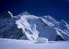
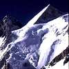
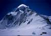
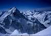
Gasherbrum II
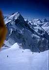
At the head of the Baltoro Glacier, at the end of one of the world's most famed mountain walks, lies the heaviest and most remote concentration of high peaks on the planet.
Gasherbrum II is part of the greater Gasherbrum group of 5 peaks, 2 of which soar over 8000m, and is the world’s 13th highest mountain. She is roundly held as one of the most straight-forward and accessible of the fourteen, and climbers on her normal route, if sufficiently resourced and prepared, enjoy reasonable summit rates in clement weather.
She is of course an 8000er, and as such repels many dozens of climbers every year. In 2004 some 38 climbers from multiple nationalities reached her summit after a small weather window opened near the end of the season.
The route of choice is the SW ridge. A mostly clearly defined spur that is relatively free of objective dangers. Nonetheless history shows more than a few climbers have perished on this route due to these causes.
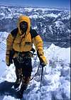
If you want to climb G2, you will need outstanding stamina, a fierce determination, and an ability to deal with 'expedition downtime' - boredom, apathy, lethargy, and cold lonely nights on the glacier.
8K peaks are to climbers what the Grand Slam series is to tennis players (with the exception that there are no spectators at 26,000ft). So if your not ready yet for your "Wimbledon" your not ready for G2.
In real terms, you should have several serious seasons of climbing at or above 6500m before you can contemplate an ascent of Gasherbrum II or any other 8000m peak.
Generally most expeditions that come here allot up to 55 days to climb this mountain from arrival in Islamabad, the capital of Pakistan.
 |
 |
 |
 |
 |
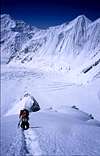
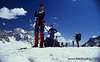
Some people dont even make it to BC...
By Himalayan standards she is one of the most remote and arduous to approach. In fact Gasherbrum II and the other 8K giants around Concordia are the only 8000m peaks on the planet not visible from any inhabited place. The jumping off point, and last town of any size, is Skardu. You can fly in a Boeing 737 to Skardu from Islamabad if the weather is good (despite Skardu having ILS pilots won't attempt to land in low ceilings - when you see the approach you will know why..). The alternative is a 36 hr land trip via the mind-boggling Karakaroram Hwy, which is a great way to see backwater country Pakistan. Try to bus up to Skardu and fly out to Islamabad if possible.
Skardu is the hopping off point for all major expeditions and treks into the Baltoro region, here you can make last minute arrangements, stock up on items, and enjoy the lazy atmosphere, ancient markets, and balmy weather.
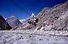
From Skardu it is a ten hour jeep drive through one of the most picturesque and enchanting valley routes in Baltistan. The access drive has variously been described as everything from "pretty" to "suicidal". We have lost a jeep on this track twice now. Pray to Allah you get neither heavy rain nor high and dry winds - both will send tonnes of rock crashing down upon the track with disconcerting regularity.
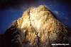
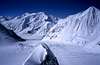
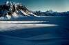
Once at Askole, the last village of any description, it is an 85 km march to Concordia along the Baltoro Glacier and past some of the most extra-ordinary and visually stunning alpine architecture to grace the planet.
Along the way you will pass the Great Trango Towers, Masherbum, Paiju, Mustagh Tower, and Mitre Peak, all the time tracing your way along a shifting but well worn path on the moraines of the mighty Baltoro Glacier.
In recent years the Pakistan Government has undertaken a major clean up of the route - today you will find new chemical toliets at many places, solar lighting around camp-sites, and depots of kerosene. All of which go towards helping the environment sustain the ever increasing burden of tourists, climbers and trekkers that arrive here each season.
None of the added luxuries however lessen the demands of this approach trek - here nature reigns supreme, and the landscape is simply too overpowering and indomitable to be tamed.
This will always be one of the wildest and most extra-ordinary mountain walks on the planet, and rightly deserves its long held place in the list of "The World's Top 5 Walks"
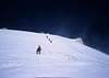
Where most trekkers turn around at Concordia, candidates for both the G2 climb and neighbouring G1 continue on to the Upper Gasherbrum glacier. This is usually one long day in near perfect conditions.
Anywhere between 7-10 days after leaving Skardu you will find yourself in the stunning circue of the South Gasherbrum Glacier, which according to the whims of the all powerful Karakoram weather system, will be either a slush filled stinking hot hell hole, or a frigid and frozen wasteland of ice.
Below is the schedule from our 2004 trip to G2:
Dates & Itinerary
Day 1 Arrive Islamabad.
Day 2 Briefing at Ministry of Tourism. Meeting with LO
Day 3 Fly to Skardu (1 hr) or drive to Chilas.
Day 4 Day free at Skardu or drive Chilas-Skardu (8-10 hrs).
Day 5 By jeeps to Askole (8-9 hrs) at 3000 meters.
Day 6 Dumordu River to Jhola (8-9 hrs).
Day 7 Trek to Paiyu, good views of Baltoro and trango group (7 hrs).
Day 8 Day free at Paiyu for acclimatization (3600m).
Day 9 To Khuburtze (5-8 hrs): 4000 m.
Day 10 Urdukas: 4-5 hrs walk mostly along the crest of lateral moraine
Day 11 Goro II: Glacier for 3-4 hrs to the camp site at 4500 meters
Day 12 Concordia: 5-6 hours slightly easy walk, with spectacular views
Day 13 6 hours trek to Gasherbrum camp.
Day 14-40 Climb Gasherbrum. Day 41-47 Return to Askole and drive to Skardu.
Day 48 Fly to Islamabad or drive to Chilas.
Day 49 Day free at Islamabad or drive to Islamabad.
Day 50 Am de-briefing, pm fly home.
 |
 |
 |
 |
 |
Dealing wth the Authorities
A permit is required, so is a Military or Tourism Ministry approved Liaison Officer. The Pakistan Government has reduced peak fees for the third year in a row, ostensibly in an attempt to lure trekkers and climbers back to the country after the terrorism alerts of 9/11.
It certainly worked in 2004 - local reports had some 6000 trekkers heading into the area, and up to 75 expeditions attempted various routes on 7 and 8000m peaks in Pakistan. It was, quite literally, packed out. The resulting logjams on the glacier, with expedition gear strewn all over the place, was a logistical nightmare. The local porters, in their new found grasp and understanding of an open market system, tripled their rates and many independent teams watched in dismay as their budgets evaporated.
Assuming the Ministry of Tourism keeps the 50% peak fee reduction in place, a climb permit will cost USD$4500 for 7 climbers, then US$750 per climber after that. You also need to pay your LO $25 per day in Cities and $15 per day in the field, plus supply him all new state of the art climbing and camping equipment, his food, accomodation, and insurance.
It is in your best interests to engage an agency in Islamabad to do this or join an organised group where it is taken care of. An environment bond of $1000 is also required, and if you want a back up rescue helicopter, a bond of $6000 will be required (in which case you really then need a satellite phone - add $200 for a permit for the phone).
Our last LO took 5 good books to base camp and spent two weeks sunbaking, and promptly sold his gear upon return to Skardu.
 |
 |
 |
 |
 |
Climb in Summer, unless your nuts..
Summer is the obvious time, and this season In Pakistan starts in May and ends in early September.
There have been no successful attempts in winter on any of the five 8000m peaks within Pakistan, this somewhat bizarre concept of extreme self flagellation is seeing an increase in devotees however. It is likely only a matter of time before somebody actually pulls it off and survives to write about it.
 |
 |
 |
 |
 |
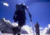
Ascent and route details - SW Ridge
Ascent outline
Camps
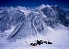
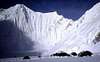
Basecamp: 5300m
Camp 1: 5900m
Camp 2: 6550m
Camp 3: 6900m-7100m
Camp 4 option usually at c7300m
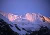
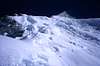
The South West Ridge Route
Description
The climbing legs on Gasherbrum II certainly favour mountaineers attempting their first big peak. Her slopes are not as steep as nearby Broad Peak, or as technical or mixed as her neighbour Gasherbrum 1. There are few objective dangers, and the camp sites are placed in mostly flat sections.
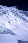
Base Icefall
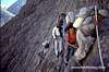
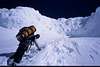
To get to the base of the route on G2 all teams first traverse the small icefall outside of basecamp. As is typical on such climbs, the route through is maintained via a collaborative effort by several expeditions at the hill. The line is fixed wherever necessary and is clearly marked with wands. The icefall is not particularly unstable or unsafe, though there are a couple of steep sections to be negotiated. C1 is set up very close to the base of the SW ridge, at just under 5900m. The normal traverse time is around 7 hours, but this decreases as you adapt to the new heights and can be cut in half by the time you make your last trip through.
The South West Ridge
Base-camp – Camp 3
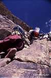
One of the great advantages of climbing the SW ridge is that it’s quite hard to get lost or off trail, even in inclement weather. The ridge is defined and maintains a fairly consistent angle. Occasionally the route swings to the right and on to the large snow face to avoid small ice bands and crevasses. The first sections of the ridge up to C2 are the steepest, and are fixed with rope, as are some sections above C2. Camp 2 itself is placed on a large sheltered platform at 6400m.
Climbing times between all 3 camp sites are a very manageable 4-6 hours on average.
Camp 3 is sited just above and to the right of the top of the ridge, again in a relatively well sheltered space, at just under 7000m. Above the tents loom the impressive rock pyramid leading to the summit. Typically climbers can expect to make 2-4 climbs to C2, and 1-2 to C3.
Because she is a popular mountain, many climbers visit her and genrally the route is well 'spiked' with wands and fixed rope often trails for hundreds of metres in all areas where a slip could have serious consequences.
 |
 |
 |
 |
 |
How to get detailed local info and weather
http://www.explorersweb.com/ have been providing daily weather reports and sending them, at absolutely no cost, to teams in the Karakoram (and for that matter to teams on most of the other 8000m peaks).
One cannot place a high enough value on this service, nor express deeply enough the thanks for their doing so.
Many climbers use their CONTACT software to send real time video and image despatches to the site.
They quite literally are the CNN of the climbing world. Hook up with them before you leave at: team@xplorersweb.com
http://www.k2climb.net/
 |
 |
 |
 |
 |
Want to join an expedition to G2?
You need to speak carefully with your propsective outfitter and make sure you know what you are getting into. You also need to carefully assess your own ability to do this climb. I have seen young climbers (under 21) turn up at 8000m base-camps on their first ever trip to the Himalayas and summit.
That does not mean however that you will be able to emulate these somewhat impressive displays of mental resolve and physical effort.
Your best bet, and certainly the safest, is to work your way up. If you have time and money you can be on an 8000er within 2 years with a fair degree of self assuredness and enough wherewithawal to limit the risk of an accident to a suitable degree.
Different operators offer different styles of trips. There are expensive ones, and there are cheap ones. Do your study and see what best suits your idea of an organised expedition.
The other option, and this should be only considered if you really know how to look after yourself, is to organise your own private group. This can be very satisfying and sometimes very cheap, and there is no feeling in the world like knocking off a big one with a few mates.
Regular Operators on Gasherbrum II:
http://www.adventure.co.nz/
http://www.fieldtouring.com/
http://www.amical.de
 |
 |
 |
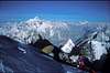
Why you must go to Concordia and K2 or G2
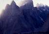
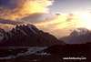
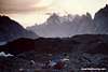
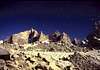
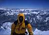
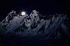
Even if climbing Gasherbrum II is not your thing, but you remain a die-hard alpine enthusiast, you must at some point in your mountain walking career visit Concordia (the glacial confluence from where all the side glaciers pour off to the adjacent 8k peaks)
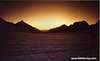
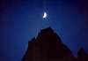
On the scale of things, this place defies description. It is the undisputed home of the planets grandest alpine scenery. This place makes much of the rest of the Himalaya look tame and well trodden by comparison.
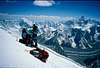
And it's not just the Baltoro approach and areas around G2 or K2 - the pics below were all taken within 2 days walking on side glaciers pouring off the Baltoro. These side trips add another level of ruggedness and remoteness to an already amazing place.
After nearly 60 trips to all the world's major mountain ranges, I remain confident I have yet to see anything as jaw-droppingly amazing as the approach to, and the immediate area around, this place we call Concordia.
 |
 |
 |
 |
 |
External Links
- Askole Treks & Tours
Adventure Tour Operating Company in Pakistan. - Jasmine Tours - Pakistan
Annual trips to all 8000m peak in Pakistan. - Saltoro Summits
Contact us for Mountaineering Expedition, Trekking Trips, Tours, Jeep Safaris and Mountain Bike Tours in the core of Karakoram, Himalaya and Hindukush Region Pakistan.
arsalank2 - Nov 5, 2004 11:35 pm - Hasn't voted
Untitled CommentGreat information. The height of Gasherbrum II is 8035m as officially declared!
jck - Jun 20, 2005 6:58 pm - Hasn't voted
Untitled CommentIn1934 G.O. Dyhrenfurth's expedition made exploration on Abruzzi Glacier.They climbed Sia Kangri(7315)-peak located in the south-east part of the glacier.
The second expedition which arrived into that area was austrian expedition led by Fritz Moravetz.He and his two team mates: Sepp Larch and Hans Willenpart climbed the top of Gasherbrum II on 7th of july 1956.Their route led from South Gasherbrum Glacier by south-west buttres,snowy terrace and then left to the summit.
Scarcely 19 years later Marc Batard and Yanic SIgneur made the second ascend.Their route was south buttres.Only 13 days after French success the top was reached by a Polish team led by Wanda Rutkiewicz.Leszek Cichy,Janusz Onyszkiewicz and Krzysztof Zdzitowiecki reached the summit via north-west wall.Few days later five Poles reached the summit.Two of them were women:Halina Kruger-Syrokomska and Anna Okopinska.
1 July 1983.Wojtek Kurtyka and Jerzy Kukuczka traversed the summit acending south-east buttres of east summit and then to the main summit and descending via normal route.
In 1984 Reinhold Messner and Hans Kammerlander reached the top climbing normal route but they descended via north wall.
Josh - Dec 17, 2005 10:32 am - Hasn't voted
Untitled CommentMinistry of Tourism Pakistan has decided to continue the 50% reduction in mountaineering royalty fee for climbing mountains above 6500-M located in Northern Areas of Pakistan during the Calendar Year 2006.
1 K-2 (8611-M) $ 6000 for 7 member
for additional member $ 1000
2 8001-8500-M $ 4500
for additional member $ 750
3 7501-8000-M $ 2000
for additional member $ 250
4 7001-7500-M $ 1250
for additional member $ 150
5 6001-7000-M $ 750
for additional member $100
WAIVER OF THE ROYALTY FEE FOR PEAKS UPTO 6500-M FOR THE YEAR 2006
Ministry of Tourism Pakistan has also decided to make an extension of one year viz, 2006 to waive off royalty fee for Peaks upto 6500-M.
Government of Pakistan also announced 10% Peak Fee (90% reduction) for mountains situated in Chitral, Gilgit and Ghizar (Tirich Mir, Noshaq Peak, Istoro Nal, Rakaposhi Peak, Diran Peak, Ultar Peak, Passu Peak and many more in order to attract expeditions for utilizing the peaks which are presently unutilized. This peak package will be for summer 2006. In these three areas there are hundreds of Peak above and between 7000m to 7500m. The full peak fee for mountain between 7000m to 7500m is 2500 US dollars for up to 7 climbers. Now 10% will be 250 US dollars only.
http://www.saltorosummits.com
dmiki - Feb 4, 2011 5:36 am - Hasn't voted
first winter ascentGII 02 Feb 2011 Simone Moro (Italy), Denis Urubko (Kazakhstan), Cory Richards (Canada)
Shahid Hussain - Apr 20, 2019 3:32 am - Hasn't voted
updated informationThank you for the great information about G2. I have noted that this article was written in 2004. There are so many changes took place during the last 14 years period. For 2019, Royalty fee for G2 is, USD $5400 for 7 members group, USD $ 900 Per additional person. Environment Fee/Waste Management Fee will be 68 US$ for each member of mountaineering expedition. Flight from Islamabad To Skardu is very frequent. Pakistan International Airline is operating an Airbus PK451on daily basis. From Islamabad To Skardu is now only 20-22 Hours drive via Babusar Pass or via Karakoram Highway. As you said in your article that it would be wise to contact a local Tour Operator to organise the trip, Documentations and get up to date information. One of the oldest and Government licence Tour Operator from Skardu is Trango Adventure. they will be happy to provide the Latest and up to date informations. info@trangoadventure.com https://www.trangoadventure.com