
-
 17947 Hits
-
 87.2% Score
-
 24 Votes
|
|
Mountain/Rock |
|---|---|
|
|
39.05670°N / 106.9545°W |
|
|
Pitkin |
|
|
Hiking, Mountaineering, Trad Climbing, Scrambling |
|
|
Summer |
|
|
13722 ft / 4182 m |
|
|
Overview
"Lightning Pyramid" is located in the Elk Mountains 0.45 miles south of Thunder Pyramid just outside of Aspen, Colorado. Thunder Pyramid is a centennial thirteener coming in at 65 highest in the state, whereas "Lightning Pyramid" is a bicentennial thirteener coming in at 137. Thunder Pyramid and "Lightning Pyramid" both lie on Pyramid Peak's long south ridge. The summit offers great views of Pyramid Peak, South Maroon Peak, North Maroon Peak, Thunder Pyramid and 13631.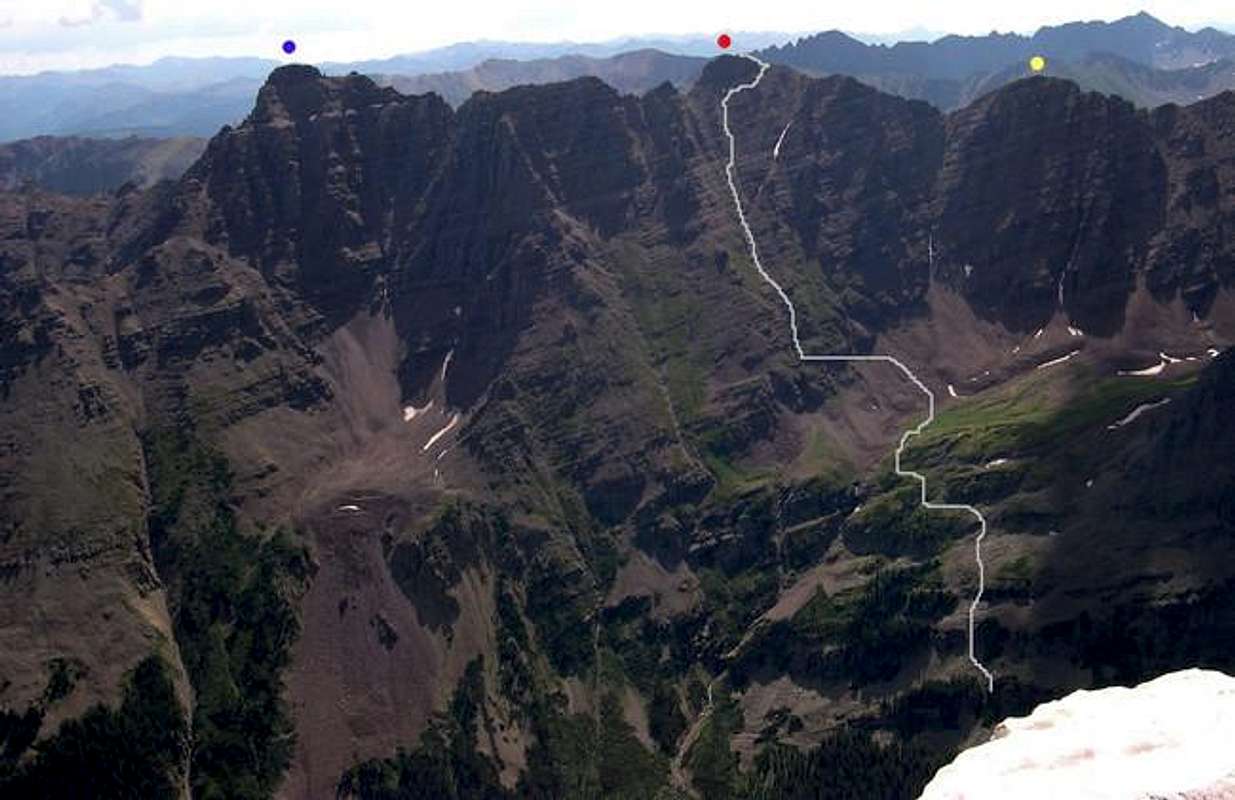
Pyramid (Blue), Thunder Pyramid (Red), Lightning Pyramid (Yellow) Credit: Kane
"Lightning Pyramid" is made up of the same loose, maroon-colored rock as Maroon Peak, Pyramid Peak and North Maroon Peak. Because of this, ascending "Lightning Pyramid" is recommended only for experienced climbers due to rotten rock and time-consuming route finding. "Lightning" is most commonly climbed via Thunder Pyramid's South Ridge outlined in Roachs' Colorado Thirteeners. However, "Lightning Pyramid" can also be climbed from UN13,631 via an interesting ridge traverse. UN13,631 is a bicentennial peak coming in at 180.
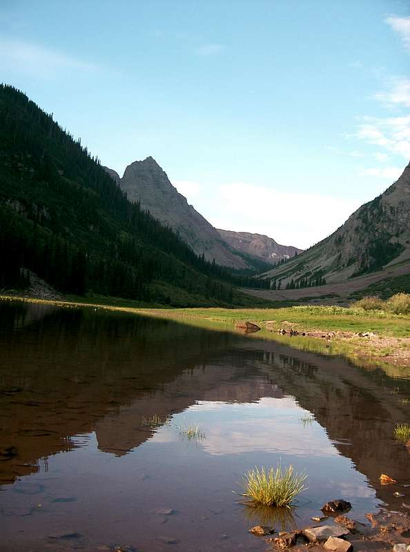
Len Shoemaker Ridge from Crater Laker
Getting There
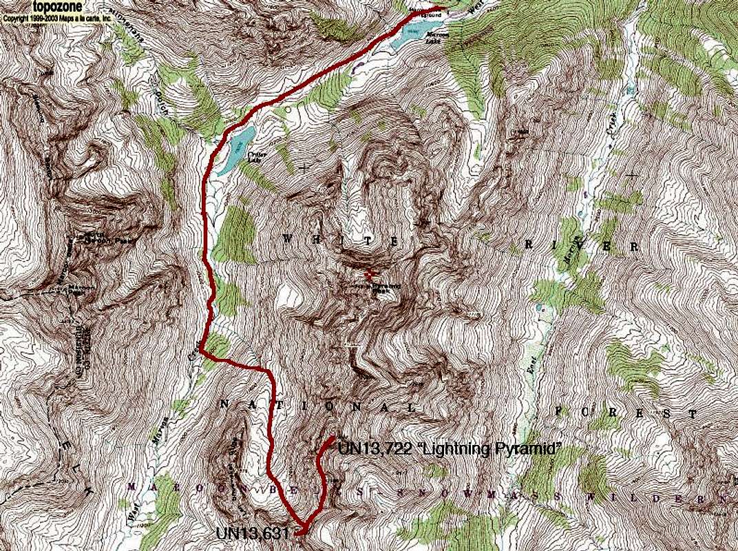
Approach "Lightning Pyramid" from the Maroon Lake Trailhead (9,590'). Drive 82 west from Aspen. Drive south on Maroon Lake Road 9.4 miles to the parking area. From mid-June through mid-October, the Maroon Lake Road is closed during the day. The hours change during this period. The closure starts as early as 7:30 am and runs as late as 7 pm. During the road closure a free bus shuttle from Ruby Park in downtown Aspen or Highland Ski Area will take you up there. Call RFTA 970-925-3445 for details.From Maroon Lake TH, hike southwest towards Crater Lake and take the left fork towards West Maroon Pass. Leave the trail at 10,600, climb east, then southeast on talus and grass to the broad basin west of Thunder Pyramid and "Lightning Pyramid". You will encounter cliff bands. Gullies allow progression up towards the basin. Continue to the basin's head. Climb left up a talus slope to the 13,300' saddle north of UN13,631. The climb south UN13,631's summit takes longer than one would think due to the ridge steps. The steps can be climbed or bypassed by staying on the east side of the ridge. Descend back to the saddle and continue to "Lightning Pyramid". There are many obstacles to avoid, but most of the climb is class 2+ with much route finding and loose rock avoidance. Stay to the right (east) side of the ridge to avoid difficulties. Descend the south ridge or continue north to Thunder Pyramid.
South Ridge Route
Red Tape
See Getting ThereAspen Ranger District Office
970 925 3445
Mountain Conditions
7 Day Forecast for Aspen, COColorado Avalanche Information Center (CAIC)
Roaring Fork Avalanche Center
Camping
West Maroon CreekOne can camp at 10,680' 1.5 miles south of Crater Lake. This is about 0.5 miles south of where the trail crosses the creek and 1,200' and 3.5 miles from the TH.
Maroon Lake Road
There are three campgrounds on Maroon Creek Road (800 280 CAMP).
Independence Pass
There are five campgrounds east of Aspen and west of Independence Pass on 82. See Kane's Thunder Pyramid page for details.