
|
|
Mountain/Rock |
|---|---|
|
|
39.07610°N / 106.9867°W |
|
|
Hiking, Mountaineering, Scrambling |
|
|
Spring, Summer, Fall |
|
|
14014 ft / 4271 m |
|
|
As of Aug, 2014 all campsites in the Crater Lake area have been closed due to Bear activity.
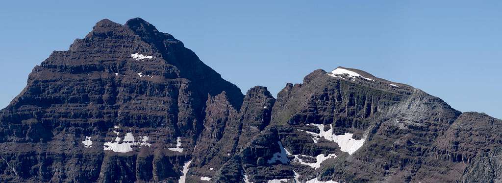
Undoubtedly, the Maroon Bells (North and South Maroon Peak) are Colorado’s most recognized mountains, for these peaks are likely the most photographed mountains in North America. The popularity is easily explainable; in spring, summer, fall and winter, these peaks are stunning to look at. It’s that simple.
Nothing beats their pyramid symmetry framed inside the gorgeous Maroon Lake u-shaped valley. The composition is perfect and memorable. And it’s why legions upon legions of vacationers visit these peaks. Lastly, a potent combination of popularity and picture perfection tends to cultivate a powerful lure among mountaineers….and the casual visitor, to make the summit.
The White River forest service likes to call them the “Deadly Bells” for every year these peaks do claim human life. Considering the high traffic, the Deadly Bells are probably not as deadly as one may think. However, it’s imperative to understand what it takes to climb these peaks and what it takes to do it in a safe manner. Ascending the Bells is a climb, not a hike.
The standard climbing routes for North and South Maroon Peak are very different, with the exception that both peaks are loose and dangerous. For South Maroon, I would describe the South Ridge Route as a strenuous exercise in route finding and determination. The route is only class 3 but it is long and steep. For most, the route will take maybe 9 to 11 hours to complete.
North Maroon’s standard Northeast Ridge Route is the proud owner of likely the most difficult crux move of any fourteener. It’s the crux that makes this route class 4. I would describe the crux as solid class 4 and a bit exposed. With snow or ice, this north facing crux makes the climbing moves very dicey and probably warrants the use of a rope. In all, North Maroon isn’t as strenuous, and doesn’t have the route finding issues of South Maroon but, it is steeper and more technical.
Mountaineering the Elks ![]()
The White River forest service likes to call them the “Deadly Bells” for every year these peaks do claim human life. Considering the high traffic, the Deadly Bells are probably not as deadly as one may think. However, it’s imperative to understand what it takes to climb these peaks and what it takes to do it in a safe manner. Ascending the Bells is a climb, not a hike.
The standard climbing routes for North and South Maroon Peak are very different, with the exception that both peaks are loose and dangerous. For South Maroon, I would describe the South Ridge Route as a strenuous exercise in route finding and determination. The route is only class 3 but it is long and steep. For most, the route will take maybe 9 to 11 hours to complete.
North Maroon’s standard Northeast Ridge Route is the proud owner of likely the most difficult crux move of any fourteener. It’s the crux that makes this route class 4. I would describe the crux as solid class 4 and a bit exposed. With snow or ice, this north facing crux makes the climbing moves very dicey and probably warrants the use of a rope. In all, North Maroon isn’t as strenuous, and doesn’t have the route finding issues of South Maroon but, it is steeper and more technical.
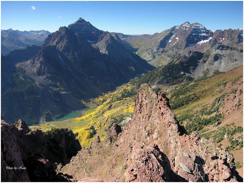
The Elk Range has six fourteeners and 4 centennial thirteeners. Indeed these mountains are some of Colorado’s most beautiful. However, beauty doesn’t necessarily translate into good climbing. The Elk Range has a reputation for loose and crumbling rock. Like most mountain ranges, some peaks are more dangerous than others; good route-finding skills are of paramount importance. Furthermore, most of the centennial peaks require top physical conditioning and good climbing skills. Only one of six fourteeners has a walk-up route to the summit. In the Elks, the use of a rope can be more of a hindrance than a tool for safety. The potential for rock-fall is always nearby.
The combination of abundant snowfall and generally steep and narrow valleys, makes access to these mountains a serious obstacle during winter months. Many of the valley slopes are ribbed with dangerous avalanche paths, which limits winter mountaineering to only the most daring and adventurous souls.
The combination of abundant snowfall and generally steep and narrow valleys, makes access to these mountains a serious obstacle during winter months. Many of the valley slopes are ribbed with dangerous avalanche paths, which limits winter mountaineering to only the most daring and adventurous souls.
- Maroon Lake Trailhead
- Approach the Maroon Bells from the Maroon Lake TH (9,590-ft.) From Aspen, locate a round-about a half mile north on Hwy 82 and drive west on Maroon Lake Road for 9.4 miles to the parking area.
Starting June 14th 2008, Maroon Creek Road restrictions will start and visitors will be directed to RFTA bus service. Buses from Aspen Highlands arrive at Maroon Lake every 20 to 30 minutes. All day users will be required to ride the bus between 9 a.m. and 5 p.m. The bus fare is $6 per adult and $4 per senior and child.
During these hours a shuttle can take you to the trailhead from Ruby Park in downtown Aspen. The shuttle ride is free. Call RFTA at 970-925-3445 or the White River National Forest at 970-925-3445 for schedules. Typically arriving before 6:00am will allow you to enter at no charge and avoid the shuttle. - John adds regarding the summer shuttles to the trailhead "The shuttle bus for Maroon Lake Road is only mandatory from June 19 to September 3, including other weekends in September. Outside of this period, you are free to drive up yourself. The road closes between 8:30 am and 5:00 pm, however, the first shuttle bus does not leave until 8:55 am (Highland Ski Area Parking Lot) or 9:00 am (Rubey Park). For more information see the Roaring Fork Transit Authority Maroon Bells page or call 1-970-925-8484 for Rubey Park Bus Information."
- The road is closed at the T Lazy 7 Ranch in winter and adds 14 miles round trip to the climb. There are no fees required when the road is closed for winter.
- The following was updated 6-30-2005 by Aaron Johnson
Several Colorado wilderness areas now require a free user permit to be in the wilderness, or shortly will require same. The wilderness areas are Holy Cross, Maroon Bells/Snowmass, Mount Evans, and Mount Massive. Permit tags are available at trailheads and are a two part tag. The white part goes in the box provided and the card portion is to be attached to the outside of your pack. There is currently no penalty if one does not have a permit. However, large fines could be levied within a few years for non-compliance. The preferred method now for dealing with violations is education of the users.
The reason for implementation of this required permit is the Forest Service has been unable to obtain accurate data on use patterns from the voluntary sign-in system. The estimated compliance range is currently 10-30%.
The hope is to obtain better data with this new method. While some may feel this is a precursor of some kind of quota system, the opposite is actually true. Accurate information on visitor use patterns will allow the forest service to attempt to evenly distribute impacts and encourage use of alternate trailheads for the same destinations. However, given the magnitude of the state's continuing population boom, folks should not be surprised if quotas in certain areas become a necessity.
Thanks to SP member mtnhiker13 for supplying this vital update via the Colorado Mountain Club's email service. - Elk Weather Forecast
-
National Oceanic Atmospheric Administration (NOAA)


- Maroon Bells Snowmass Wilderness-Red Tape
-
- The Peak is in a Wilderness Area and Wilderness rules and regulations apply. There is a FREE required registration at the trailhead. See the Permit section below for details.
- Current information regarding the Wilderness area can be found on the official National Forest Service website.
- The NFS Ranger Station can also be reached by the following:
Aspen Ranger District806 West HalamAspen, CO 81611
Phone: (970)925-3445Fax:(970)925-5277. - Area Camping
-
- As of Aug, 2014 all campsites in the Crater Lake area have been closed due to Bear activity.
- Forest service campgrounds in the Aspen area offer everything from primitive camping to RV hookups. Maroon Creek road has three campgrounds, all of which require reservations. Call the number above and expect to pay $15.00 a night. Call as far in advance as possible for a site in this popular area. Those wishing to make reservations should call 1-800-280-CAMP. There is an $8.25 reservation service charge.
Independence Pass Camping
Five campgrounds along Colorado Hwy 82 via Independence Pass offer numerous sites. The following campgrounds are located on the west (Aspen side) side of the pass. - Difficult Campground has 47 sites and is only 5 miles from Aspen. Reservations accepted by number above. $10.00 a night.
- Weller Lake Campground has 11 sites and is 7 miles from Aspen. First come first serve. $10.00 a night.
- Lincoln Gulch Campground has 7 sites and is located 11 miles from Aspen. First come first serve. $10.00 a night.
- Lost Man Campground has nine sites and is 14.5 miles from Aspen. First come first serve. $13.00 a night.
- The best kept secret in the area for camping is up the Lincoln Gulch Road (11 miles from Aspen) past the Lincoln Creek Grattos and close to Grizzly Reservoir where camping along this rough road is free. This is not a road for trailers.