
-
 15925 Hits
-
 76.66% Score
-
 7 Votes
|
|
Mountain/Rock |
|---|---|
|
|
37.79673°N / 107.59868°W |
|
|
San Juan |
|
|
Hiking |
|
|
Summer |
|
|
13416 ft / 4089 m |
|
|
Re-addition of Little Giant Peak
March 2001 I added Little Giant Peak to Summitpost. It was then adopted by somebody that did nothing with the page and was not improved. Then along came Aaron and took over the page and made it one of the most impressive 13er pages on the Colorado part of Summitpost. In my opinion it was the best done 13er page on summitpost. He had listed history of Silver City next to Silver Lake. I had searched for this ghost town on ghosttowns.com and they don't even know about this decaying town.Now, Aaron had left Summitpost deleting many of his pages. Little Giant is one of those pages. 11 years later I am re-adding this peak. I'm starting with finding the photos then will be adding text. The page will be nowhere near as informative and interesting as it once was. It's going to take me some time to get this page looking good. Please be patient...
Overview
This peak is nearing completion. I found all the photos I'm going to find. The "Overview" is pretty much done and so is the "Getting There" section. you have any photo's of this peak or of Silver Lake please post them. The next part to complete is the least important part of the page, the "Silver Lake" section.If you have photo's of this peak please add them.

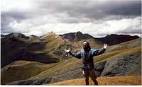
Little Giant Peak is near the town of Silverton. It's the third highest peak in its grouping of peaks, with Kendall Peak being the highest. Little Giant is a very difficult summit to reach. Most of the hike and any side is on trails, but they are all very steep. The upper parts of the peak is all off trail and is up talus and scree. From looking at Aaron's photos he says that the top of the peak has a small amount of class 3. There are 3 routes up that I am aware of and they are on undesirable loose scree. This peak is quickly deteriorating and the summit sits on top of a diagonal sulfur band.
There is evidence of mining all over Little Giant Peak. The Dives Basin route has collapsed mine shafts from the Shenandoah mine. Near the top of the valley there are tailing on the mountain side. These areas can be dangerous and a potential hiking hazard. Arrastra Gulch has many mines, the abandoned Aeriel tramway that is still suspended, and a ghost town at Silver lake. If your interested in Colorado mining history, this mountain could provide quite an adventure. Although the ghost town at Silver lake is quite decrepit and I am not aware how many buildings if any at all are still standing. The Pictures of Silver City here on Summitpost were taken by Aaron Johnson in the 1980's.
Rank: 309th highest peak in Colorado
Prominence:556 feet
USGS Quad: Howardsville
Getting There

This approach can be done with a 2WD with not much clearance. No chance of bottoming out, but the road does get narrow enough in spots that only one can can fit through. From Silverton take rd 110 heading towards Cinnamon Pass. From Howardsville take a right up Cunningham Gulch. The trail is near the back of the valley near some campsites. The trail head can be hard to find. If you look hard enough you will see a trail heading up the mountain. You can bushwhack your way to the trail. It's an old mining trail leading to Dives Basin. The trail is very steep, and disappears sometimes near the top of the basin.

If anybody has information on these 2 routes, I could greatly appreciate some help
Any road up Arrastra Gulch requires 4WD. Arrastra Gulch is used for both the Little Giant Basin Approach and the Silver Lake Approach.
Drive northeast out of Silverton on County Road 110 for 2 miles. Turn right onto the Arrastra Gulch Road, across from the Mayflower Mine building. The road drops down immediately and crosses the Animas River and then climbs in to Arrastra Gulch.

The Arrastra Gulch road turns off to the right from County Road 110 just before the Mayflower Mill. It descends to the old Silverton Northern grade and crosses the Animas River. Shortly after crossing the river a road will branch off to the right leading to the site of the Aspen Mine.
The Aspen Mine road fords Arrastra Creek right after the turn off the Arrastra Gulch road. After traveling up a steep section, you'll arrive at the Aspen Mine. Turn right at the intersection with the Arrastra Gulch road.
Tram towers and tower foundations can be seen as you move up the road.
A road leading off to the right as you proceed up the gulch leads to the ruins of the Iowa-Tiger Mill.
Past the turnoff for the Iowa-Tiger Mill the main road continues bearing to the right. The Little Giant Basin Road turns off to the left up several switchbacks to Little Giant Basin. This road is steep and narrow. Above treeline on the face of King Solomon Mountain there is a tight switchback which requires backing up to negotiate. The road runs toward the back of the basin until it reaches Gold Lake.
 |  |
(Copied and pasted from the Kendall Peak page. Continue east from Silverton on County Road 2. Right after a large gray mining building on the north side of the road, there is a turn-off for County Road 52. Travel down and cross the canyon/river. There will be a fork about .4 miles along the road: go left. The next for after is another left (obvious due to sign pointing the correct way). Go as far as your vehicle will take you. We stopped at 10,300' in a car without much clearance.-Garon Coriz
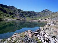
Silver Lake
Photos of Silver Lake City. If you have photos of this ghost town please add them.| |  |  |

Camping
There is a lot of camping choices to choose from around Silverton. If you want to pay to camp there is the campsite on Molas Lake for $14 per night.If you don't want to pay, there are many spots you can find along the Animas River. Up Cunningham Gulch there is a small camping area as well.