Overview
Meadow Mountain - not to be confused with the
Meadow Mountain east of White Chuck Mountain - is a 4620' (840' prom.) forested hill located 11 miles northeast of Granite Falls, and four miles west of Three Fingers Mountain. When viewed from a distance, the name 'Meadow Mountain' seems to be something of a misnomer - it does not appear to be 'meadowy' at all. Closer inspection, however, reveals a number of small clearings near the summit area, as well as several nice viewpoints.
Several decades ago, Meadow Mountain was doomed to a life of solitude and neglect, as the result of a shortcut trail to the Three Fingers area via Tupso Pass. The Meadow Mountain Trail, which was once the normal access for Three Fingers and Goat Flat (along with the Boulder River Trail) became overgrown and choked with blowdowns. Recently, however, the Tupso Pass trail has become less popular - this is due to the fact that the Forest Service has effectively closed the last 8.6 miles of FR41, the access for Tupso Pass. (As of 2014, there appears to be no effort being made to repair this road.)
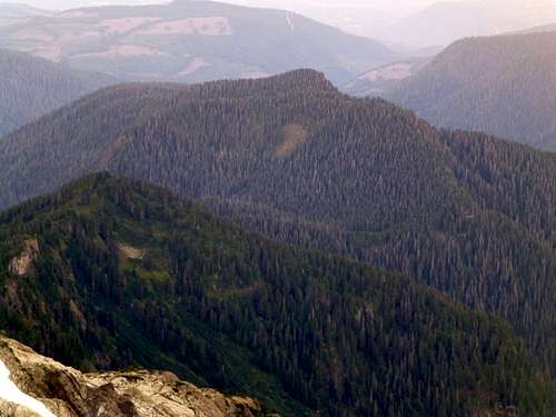
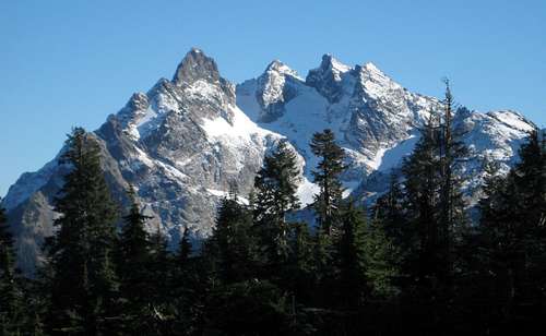
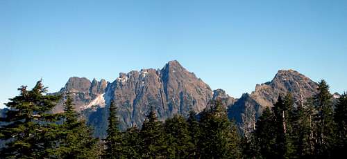
![Meadow Mountain from Goat Flat]() Meadow Mountain from Goat Flat - Mount Ditney to the right.
Meadow Mountain from Goat Flat - Mount Ditney to the right.
Recent work by volunteer trail crews has now breathed new life into the Meadow Mountain Trail, and it has once again become the standard approach trail for the Three Fingers area. Truthfully, few people will make Meadow Mountain a destination in it's own right. Having said that, for those heading to Goat Flat and beyond, it is well worth the 10-15 extra minutes it takes to pay homage to this lonely summit.
Getting There
From Granite Falls, follow the Mountain Loop Highway approximately seven miles, and turn left on FR41 (across the street from the Robe Canyon Trailhead). Follow FR41 8.4 miles to the South Fork Canyon Creek bridge (stay left at the major fork at 1.8 miles). Here, the road effectively ends, as the Forest Service has placed large boulders at the bridge approach. Surprisingly, the standard 'No Motorized Vehicles' signs are conspicuously absent, which suggests that one could continue by motorcycle if so equipped. From this point, a 2.3 mile walk up the closed portion of FR41 will bring you to the Meadow Mountain Trailhead - if you own a mountain bike, it will save you some time. The Meadow Mountain Trail is not marked, and can be easy to miss. It is located about 1000' past Saddle Creek, which will be the only creek crossing of significance before reaching the trailhead.
Route
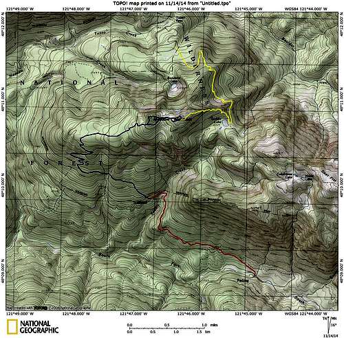
![Meadow Mountain route map]() Meadow Mountain route map. Red line shows the walk/bike on FR41, yellow line shows an optional routing from Tupso Pass.
Meadow Mountain route map. Red line shows the walk/bike on FR41, yellow line shows an optional routing from Tupso Pass.
Begin up the Meadow Mountain Trail - there will be a few newer blowdowns (easily negotiated), but all of the old trail-blockers from years past have been removed. At about 2800', the trail will level off, and traverse in a W/NW direction for about one mile. Several watercourses will be crossed through this section, but the volunteer trail crews have done an excellent job cleaning up the approaches. Finally, after about 1.5 miles, the trail will get down to business, and switchbacks uphill from 2800' to 3800'. Upon reaching 3800', the trail will again level off, and you will find yourself heading east through intermittent clearings. The trail can be somewhat hard to follow through this section, as there has not yet been enough foot traffic to kill back the grass. Keep your eyes open for occasional flagging to stay on track at this point - if you are directionally-challenged, plan to use a GPS. Arriving at 4400', about 4.5 miles from the trailhead, you will find yourself just south of Meadow Mountain's west (true) summit. From this point, the summit is a simple, five-minute scramble through open forest. Initially, it will appear as though it will yield no views - just as you arrive at the top, you will find small clearings that will provide expansive views to the north and west. Use caution in this area, as there are cliffs on the north and west sides of the summit.
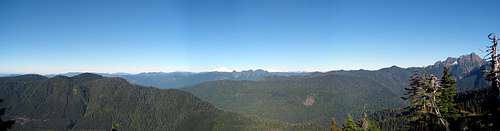
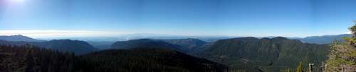
![Meadow Mountain west summit - north pano]() Meadow Mountain west summit - north pano. In the foreground - Mount Ditney, Boulder Ridge/French Peak, Whitehorse Mountain. In the background - Twin Sisters, Mount Baker, Mount Higgins, Round Mountain, Mount Shuksan, The Pickets
Meadow Mountain west summit - north pano. In the foreground - Mount Ditney, Boulder Ridge/French Peak, Whitehorse Mountain. In the background - Twin Sisters, Mount Baker, Mount Higgins, Round Mountain, Mount Shuksan, The PicketsTo get the good views of Whitehorse, Bullon, and Three Fingers, it will be necessary to head over to the east summit, about one-third of a mile away. Travel between the two summits is relatively easy, through open forest and meadow, or one could return to the trail if desired. Use caution on the east summit, as there are fairly substantial cliffs on the north side.
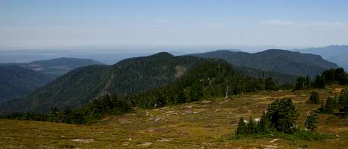
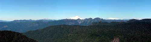
![Meadow Mountain east summit - north pano]() Meadow Mountain east summit - north pano
Meadow Mountain east summit - north pano
Red Tape
A Northwest Forest Pass is not required to park at the end of FR41, and a wilderness permit is not required for the Boulder River Wilderness.
When to Climb
June through November would provide a mostly snow-free experience. Meadow Mountain would probably be an acceptable snowshoe objective (low avalanche danger), provided one could drive to the Canyon Creek bridge.
Camping
While there are plenty of small meadows where one could camp on this mountain, the vast majority of overnight visitors will likely go to Goat Flat, Saddle Lake, or the Three Fingers lookout.