
|
|
Mountain/Rock |
|---|---|
|
|
45.79878°N / 10.76706°E |
|
|
Hiking, Scrambling, Via Ferrata |
|
|
Spring, Summer, Fall, Winter |
|
|
3009 ft / 917 m |
|
|
Overview
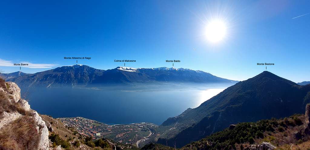
Monte Bestone 917 m
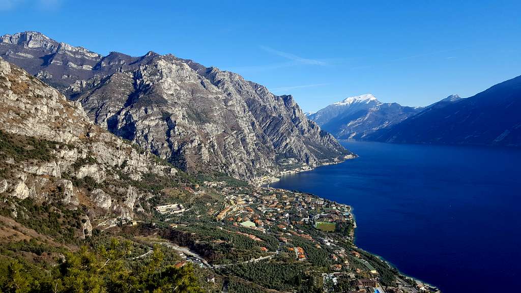
Monte Bestone 917 m is a minor but very well identified summit, overhelming the small town of Limone on the Western shores of Lago di Garda and belonging to the Prealpi Bresciane e Gardesane. The mountain is of particular interest in reason of its beautiful location overlooking the Garda Lake and its broad panorama.
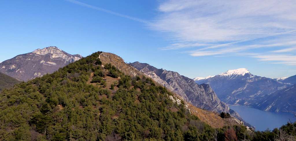
The most interesting itinerary, but not the easiest to get the top, runs along the Eastern side of the mountain, constantly dominating the water mirror of the lake. It is called "Senter delle Farfalle", meaning "Butterflies Path". In addition to this stunning itinerary, the small peak which is worthy in reason of the amazing panorama can be reached through other two different itineraries: from the wild Val Pura or from the short and easy via Normale from the hamlet of Voltino.
Getting There
The starting point to approach Monte Bestone is Limone del Garda, a lively tourist center located on the western shore of Lago di Garda. Limone can be reached coming from Brescia or conveniently from Riva del Garda across the Western Gardesana road.
- From the A4 Milano-Venezia motorway, exit Brescia Est, reach Salò and take the Gardesana Occidentale to Limone.
- From the A22 Autobrennero exit Rovereto Sud, reach Riva del Garda and take the Gardesana Occidentale to Limone.
Monte Bestone Normal route
Monte Bestone Normal route
Summit quote: 917 m
Difficulty: T
Difference in level: about 200 m
Short tourist route suitable for beginners. The summit panorama is interesting. Recommended for beginners or as a descent route after traveling the beautiful "Senter delle Farfalle" (see next chapter).
Access
Coming from Riva del Garda you will travel along the Western Gardesana state road towards the south. Once getting Limone sul Garda, just after the town center, find the right fork to Tremosine. The road reachs the small hamlets of Ustecchio and Voltino. In coincidence with this latter hamlet we find on the right the signposts to "Pineta Campi - Le Balze". It is possible to proceed, even for a while, with the car taking as high as possible until you pass the village "Le Balze". The road is blind and ends at some tennis courts on the left while on the right there is a complex of small holiday homes.
|
|
Description
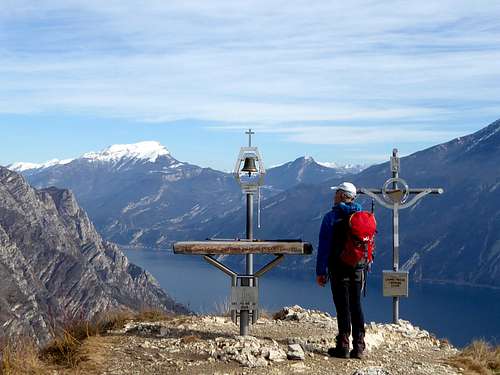
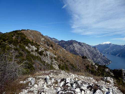
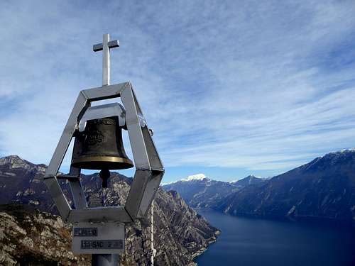
The signpost indicates the easy path that continues beyond the houses of the tourist complex to enter the woods A first short digression to the left, unmarked, leads in a few meters to a panoramic pulpit with a bench. We continue on the path in the forest now sparse (traces of a fire) continuing on a panoramic ridge with a shelter. To the right of the lake the sequence of peaks of Monte Baldo is visible. The Bestone begins to be visible in front. From the panoramic ridge descend to a marked saddle immersed in the woods where we find some signposts. Ignore the road with hairpin bends that crosses our route and continue to resume the climb following the wide dirt road in front that cuts diagonally the slope. After a hunting lodge in a large clearing on the left, we continue to climb out of the forest again and on the wide summit crest on obvious track we reach the summit plateau with spectacular views. Cross, bell and peak book.
Descent: reversing the route
Senter delle Farfalle
Monte Bestone across the "Senter delle Farfalle"
Summit quote: 917 m
Difficulty: EEA
Difference in level: 800 m
Magnificent route that winds on steep path and requires familiarity with exposure, in constant view of the lake and the surrounding mountains. Some sections are equipped with metal cable.
Access
Once arrived in Limone leave the main Gardesana road and take on the right - coming from Riva - a road with signposts Campaldo and follow it until you reach the Bar restaurant Campaldo beyond which the transit is prohibited to motor vehicles. Few parking possibilities. Continue for a few hundred meters on foot along the restricted road, ignore a first path on the right (to Val Pura) and continue until you reach a second path that comes off on the right with CAI 138 table, butterfly and signpost "Senter delle Farfalle ".
Route description
Take the path that at first runs with some hairpins between the olive groves, then head to the left with a long crossing and some ups and downs in the pine-wood to reach a crossroads marked with CAI tables: on the left you go down to Limone along a variant, on the right you continue to the Senter delle Farfalle and Monte Bestone. Turn right and start climbing steeply up to a panoramic shelf overlooking the lake.
Continue directly - signpost "Monte Bestone" - on the steep path that comes close to a pylon, overcomes some easy and slightly exposed rocks and arrives at a junction with a sign on the left to "Voltino" (it will be our return path). Continue straight towards the rocky ridge above and reach the beginning of the stretch equipped with metal cables. Begin to climb up the equipped route following the cables crossing to the left and going up with some exposed stretches along the steep rocky buttress, leading to a second panoramic shelf.

|

|

|

|
After the terrace we continue to climb up steep terrain, meeting again a couple of sporadic equipped sections until we exit on a saddle from which it appears the summit cross of Monte Bestone. From the saddle descend slightly along a short ridge and on easier terrain start to climb towards the top (remains of a fire).
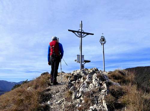
You reach a last junction, where you turn left (signpost "Monte Bestone") and on open ground you will soon reach the beautiful summit with cross, summit bell and summit book.
Descent: across the Normal route till Le Balze. From here you must follow another path to close the ring and reach the car parked at Campaldo. Getting to the complex of small holiday homes, don't follow the red-white marks, but take on the left the "Via delle Alpi" (there is a wooden signpost "Nordic Walking"). This road descends to intercept a junction with a white road coming from Voltino. At the crossroads you must turn left and proceed to the mule track which immediately becomes a small horizontal trail, which crosses the entire eastern side of Monte Bestone, easy but with different exposed sections that require firm foot, and ends onto the Senter delle Farfalle a few tens of meters above the electricity pylon. At this point reversing the ascent route you will descend to Campaldo.
Red Tape
There are not special restrictions in climbing, hiking and mountaineering.
Hiking and scrambling grades of difficulty
T - Turistico (Tourist): Itineraries on wide, clear and well worn paths, sometimes on mule tracks or gravel roads. The routes are never exposed, don't give any orientation problems and don't exceed 2500 meters of altitude. Suitable also for children.
E - Escursionisti (Hikers): Itineraries on marked trails, even narrow and with possible steep and impervious sections. They are never exposed and don't give any orientation problems. They can tread different kinds of ground, such as forests, gravel, meadows, pastures, easy rocks, etc.). They form the majority of the trails that wind up in the mountains and require a certain habit to walk; you need equipment suitable for the altitude and resistant footwear with soles suitable for rough terrain.
EE - Escursionisti Esperti (Experienced Hikers): Itineraries for hikers with experience and good knowledge of the mountain. Some of these paths may have exposed sections, however brief, which require firm foot and no dizziness. They require the ability to adapt to particular terrain, such as steep grassy slopes or stretches of rocks with difficulties that can reach the 1st degree of the UIAA scale. They can also reach high altitudes (3000 m or more). Sometimes they may include unmarked sections, requiring a good sense of orientation. Snow slopes are possible, however which can be overcome without specific mountaineering gear (rope, harness, crampons, ice-axe).
EEA - Escursionisti Esperti con Attrezzatura (Experienced Hikers with equipment - The same as EE, in addition these routes require the use of via ferrata equipment (lanyards, harness, carabiners, heat sink, helmet). This kind of itineraries range from the trails with short easy and not much exposed sections, previously equipped with fixed ropes and iron pegs, to the true and more difficult Via Ferratas climbing on rocky walls or on aerial ridges and ledges, previously equipped with long stretches of iron ropes, iron steps, ladders without which proceeding would constitute a real climbing. It is necessary to know how to use the technical equipment and have a certain habit of exposure and mountaineering terrains.
When to Climb
All year round
Accomodation
This area is a primary touristic destination, offering several hotels, agriturismo, bed and breakfast, renting rooms and apartments.
Bibliography
"Prealpi Bresciane" by Fausto Camerini - Collana Guide dei Monti d'Italia, CAI-TCI