
|
|
Mountain/Rock |
|---|---|
|
|
45.87366°N / 10.71119°E |
|
|
Trentino Alto-Adige |
|
|
Hiking, Mountaineering |
|
|
Spring, Summer, Fall, Winter |
|
|
5679 ft / 1731 m |
|
|
Overview
Monte Corno m. 1731
Immediately to the South of Lago di Ledro it's located a small chain in shape of a rocky castle named Caset-Corno ridge, belonging to the Prealpi Bresciane and Gardesane, sector Alpi di Ledro. A few summits are lined up along this ridge, amongst which the Northernmost one is Monte Corno m. 1731. As the majority of the mountains located around Lago di Garda, this small range was directly involved in the fighting during the World War I, when the Italian and the Austro-Hungarian armies faced each other from the summits.
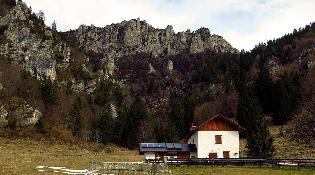
The whole Caset-Corno ridge was used by the Italian troops as an observatory, in fact this small chain is located above the WWI front line that stretched from Lago di Garda to the Adamello peaks. Also Monte Corno was an outpost of the Italian army; its summit, where is located a big cross, is a wonderful panoramic terrace projected over Lago di Ledro and overhanging the water mirror from the South-West.

The Southern route from Lago di Ledro shows many reasons of interest: historical, environmental and scenic.
Getting There
There are two possible starting points to climb the mountain from Lago di Ledro (from the South):
- Malga Cita located in Val Scaglia
- Dos de Pur along Lago di Ledro Southern shore
Road access to Malga Cita
Coming from the Auto Brennero A22 exit Rovereto Sud and take the road to Riva del Garda. Pass Mori, Nago and Arco and carry on in the direction of Riva del Garda. Before reaching the town take the road to Val di Ledro. After driving through two long tunnels we enter the narrow Val di Ledro. We pass the villages of Biacesa and Prè, getting to Molina di Ledro. Here we leave the main road to Mezzolago and take the road running along the South shore of the lake, then entering Pian di Pur and reaching Malga Cita 750 m. Parking lot.
To climb the mountain from Passo Casèt (second itinerary) you have two possibilities:
- drive up to Passo Tremalzo
- alternatively you can reach Passo Casèt by walking from Malga Giù
Nature and flora
This small mountain group is a nice destination for botanical trips. During the spring, in addition to the various and most common species of flora present in the woods and meadows along the proposed route, amongst the summit rocks you can find the rare Moehringia glaucovirens, an endemic species, and the equally rare Saxifraga tombeanensis.

|
")
|
Route: Monte Corno from Malga Cita
Monte Corno from Malga Cita
Summit quote: 1731 m
Difficulty: E
Difference in level: 980 m from Malga Cita
Exposition: mainly South-East, the final ascent to the summit is facing NW
Time required: 4 hours round trip
Starting point: Malga Cita m 750
An interesting route with a long develope and low difficulties.
From the parking lot near Malga Cita, we continue on the forest road (n. 419) which enters the Val Scaglia, reaching after a few minutes a road-bar at about 800 meters of altitude. After a gentle start, the trail becomes increasingly steeper, through meadows and forests, reaching a source at 915 above sea level.

|

|

|
Here it's interesting to take a look and see the result of the work done to stop an old landslide. Getting the junction at 1196 meters of altitude, there are two options: to continue along the path CAI 719 getting to the beautiful grassy basin of Malga Giù m. 1277, a big restored alm, or alternatively (shorter) turn to right on the path 456/d, directly reaching Cà de Mez and the beautiful tiny Church of Sant'Anna. From the meadows leave the path CAI 419 to Bocca Caset and take the path CAI 456 - not very obvious at its start - that after two subsequent crossroads (always keep the direction to Bochet de la Spinera) crosses mainly horizontally the southern slopes of the ridge Caset - Monte Corno to reach Bochet de la Spinera. Signposts.

|

|

|
From the wooden saddle turn to left following the signpost to Monte Corno. The path climb steeply inside the wood, then traverses along the slopes and finally rises again to reach a saddle between Monte Corno on the right and the rocky ridge formed by the other peaks, crossed by the via ferrata Mora-Pellegrini on the left. From the saddle turn to right and follow the NW slopes - often snowy until late spring - and the summit crest. On the summit it appears a wide 360° panorama over the two lakes (Ledro below feet, Garda to the right) and major mountain ranges of Trentino. Summit cross and summit log.

|

|
Descent: reversing the route
Route: SW ridge - Sentiero Attrezzato "Mora-Pellegrini"
Monte Corno across Sentiero "Mora-Pellegrini"
Summit quote: 1731 m
Difficulty: EEA
Difference in level: 130 m from Passo di Casèt, 980 from Malga Cita
Time required: 4 hours round trip
Starting point: Passo di Casèt m 1608

|

|

|
It's a suggestive partially equipped route, which runs through the small chain, starting from Passo di Casèt 1608 m. From the pass take a small road heading North and leave on the left the road descending to Malga Caset. Carry on along the SE slope of Cima Caset, the first summit, overcoming the Bochèt del Gat 1710 m and bypass the Corno Piccolo. After some ups and downs between mountain pines and easy rocks, the route downclimbs inside a 25 meters crumbly gully, equipped with iron cables, and continues to the left along a ledge. The route crosses a natural hole in the rock, and after a short descent, climbs up the grassy slope toward the Corno Grande. After reaching the crest and by-passing some outcrops, the path downclimbs within another steep gully equipped with metal cables, reaching Bochèt di Caset 1650 m, where it joins the previous route, along which to the summit of Monte Corno.
See here on SP a detailed report of the route: Sentiero Attrezzato Mora - Pellegrini
Hiking and scrambling scale
T - Turistico (Tourist): Itineraries on wide, clear and well worn paths, sometimes on mule tracks or gravel roads. The routes are never exposed, don't give any orientation problems and don't exceed 2500 meters of altitude. Suitable also for children
E - Escursionisti (Hikers): Itineraries on marked trails, even narrow and with possible steep and impervious sections. They are never exposed and don't give any orientation problems. They can tread different kinds of ground, such as forests, gravel, meadows, pastures, easy rocks, etc.). They form the majority of the trails that wind up in the mountains and require a certain habit to walk; you need equipment suitable for the altitude and resistant footwear with soles suitable for rough terrain
EE - Escursionisti Esperti (Experienced Hikers): Itineraries for hikers with experience and good knowledge of the mountain. Some of these paths may have exposed sections, however brief, which require firm foot and no dizziness. They require the ability to adapt to particular terrain, such as steep grassy slopes or stretches of rocks with difficulties that can reach the 1st degree of the UIAA scale. They can also reach high altitudes (3000 m or more). Sometimes they may include unmarked sections, requiring a good sense of orientation. Snow slopes are possible, however which can be overcome without specific mountaineering gear (rope, harness, crampons, ice-axe)
EEA - Escursionisti Esperti con Attrezzatura (Experienced Hikers with equipment - The same as EE, in addition these routes require the use of via ferrata equipment (lanyards, harness, carabiners, heat sink, helmet). This kind of itineraries range from the trails with short easy and not much exposed sections, previously equipped with fixed ropes and iron pegs, to the true and more difficult Via Ferratas climbing on rocky walls or on aerial ridges and ledges, previously equipped with long stretches of iron ropes, iron steps, ladders without which proceeding would constitute a real climbing. It is necessary to know how to use the technical equipment and have a certain habit of exposure and mountaineering terrains.
Red Tape
No fees no permits required. Cars are not allowed beyond Malga Cita 747 m.
Essential gear
In wintertime, according with the conditions, crampons and axe are needed.
Accomodation
Several possibilities of accomodation in Val di Ledro.
When to climb
All year round – In winter condition the ascent require the use of axe and crampons
Bibliography
LagirAlpina map
"Prealpi Bresciane" by Fausto Camerini - Collana Guide dei Monti d'Italia, CAI-TCI
"Guida alle Alpi di Ledro" by F. Torchio - E. Gardumi, Panorama, Trento, 1995
Maps
"Alpi di Ledro - Tremalzo"- LagirAlpina sheet 16 - 1:25.000
"Alpi di Ledro Valli Giudicarie"- KOMPASS sheeet 071 – 1:50.000
"Garda-Trentino" map scale 1:30.000