
|
|
Mountain/Rock |
|---|---|
|
|
45.87238°N / 10.82181°E |
|
|
Trentino Alto-Adige |
|
|
Hiking, Scrambling, Via Ferrata |
|
|
Spring, Summer, Fall, Winter |
|
|
3573 ft / 1089 m |
|
|
Overview
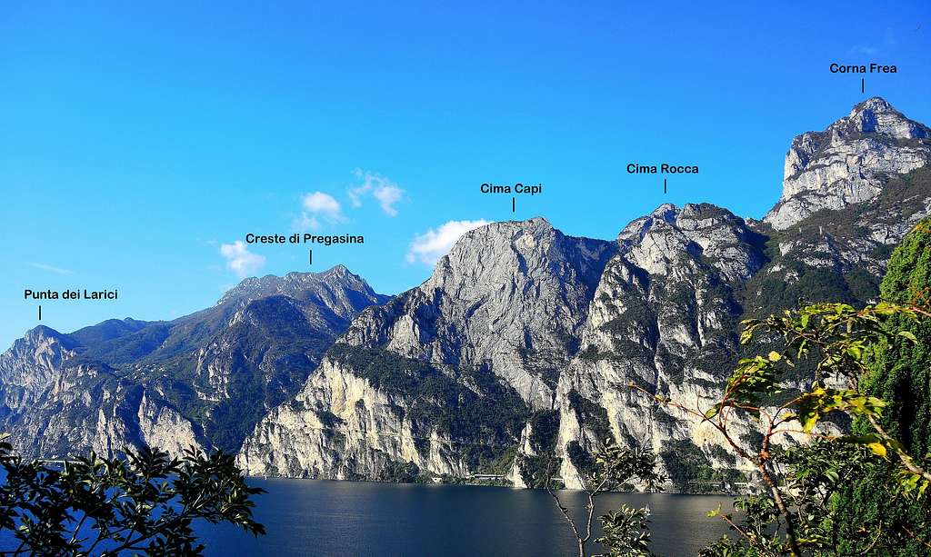
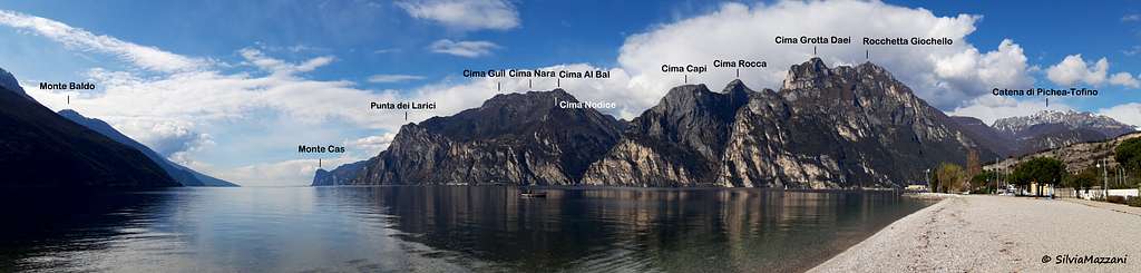
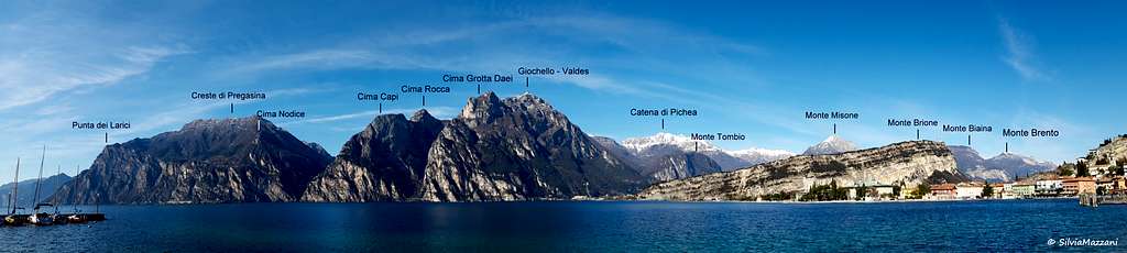
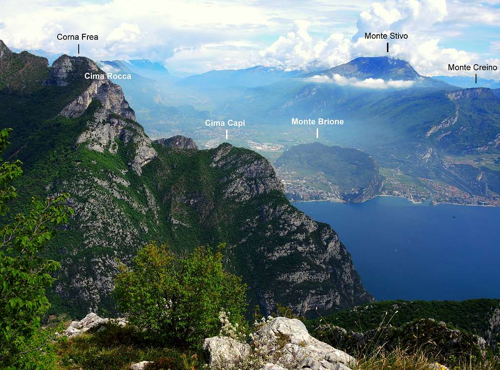
Cima Rocca m. 1089
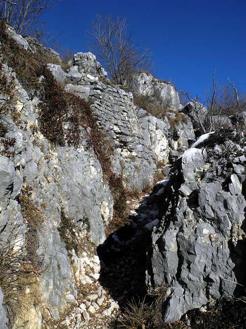
Not a high peak, but very interesting! Cima Rocca 1089 m is a limestone rock piramyd belonging to the Prealpi Bresciane and Gardesane, sector Alpi di Ledro, and dominating the village of Biacesa in Val di Ledro and the lower Cima Capi. This pyramid, also called Sperone della Rocchetta, is surmounted by a cross. Three reasons make the ascent to Cima Rocca a fine experience: the interest of the approach trail and the next Via Ferrata, the breathtaking views over the near Garda Lake and above all the important and well preserved remains of the First World War, a powerful defensive system built by the Austro-Hungarians on this mountain lying in a strategic position, with the purpose to check from the top the enemy troops' movements. The location of the mountain was considered so important that the Italians several times tried to conquer the summit without success. Cima Rocca is surrounded by numerous trenches and perforated by several tunnels, including that one extending itself for about 300 meters, entirely dark.
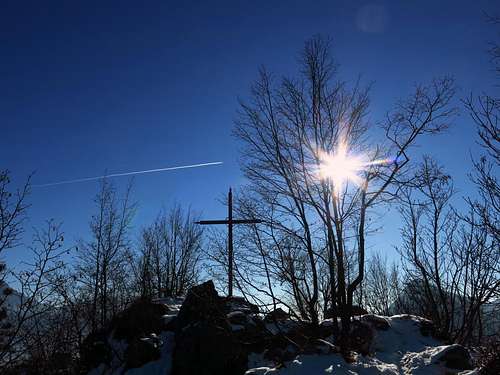
Summit of Cima Rocca |
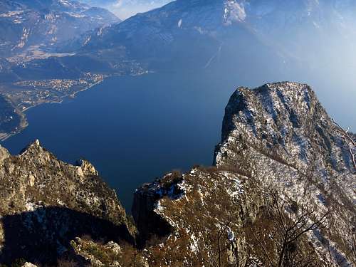
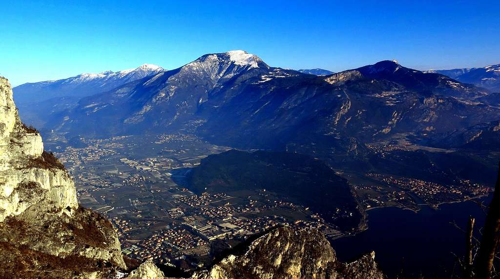
Spectacular view over Garda Lake and Cima Capi from Cima Rocca |
Getting There
Access: from the Brennero autoroute exit Rovereto Sud and take the road to Riva del Garda. From here follow the road to Val di Ledro, leading through a couple of tunnels to the small village of Biacesa di Ledro m. 418.
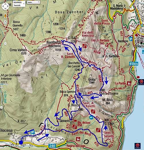
Route: Cima Rocca Normal route from Biacesa di Ledro
Cima Rocca Normal ascent from Biacesa di Ledro
Difficulty: EE
Difference in level: 670 m from Biacesa di Ledro
Route partially equipped with iron ropes and a ladder, that allows the ascent of the rocky southern slopes of Cima Rocca. The proposed itinerary has a strong historical character as it links the various forts, tunnels and buildings dating from the World War I. Very characteristic the tunnels, well preserved.
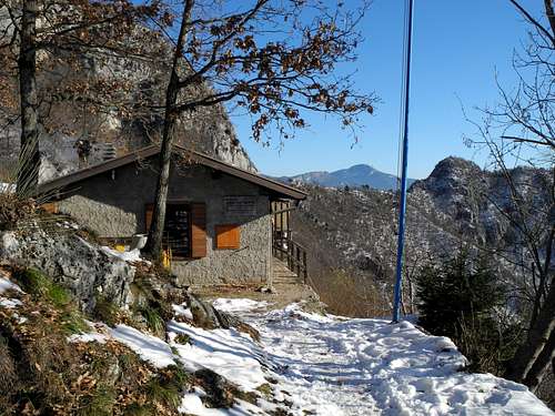
Bivacco Arcioni |
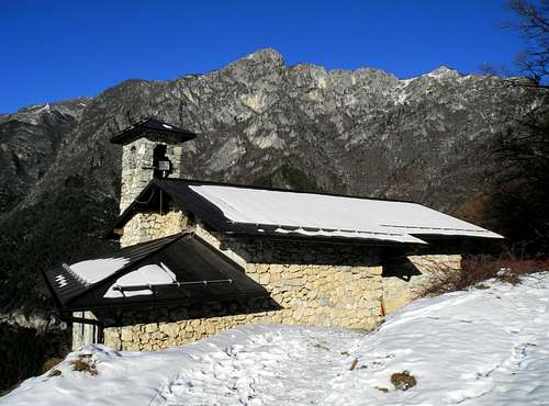
The church of San Giovanni dominating Biacesa |
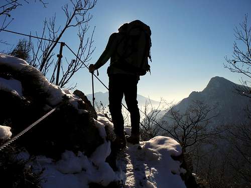
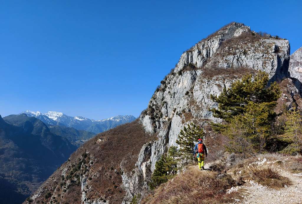
Along Via Ferrata |
Reached the only traffic lights in the village of Biacesa turn to right and follow the signposts to Cima Capi and Cima Rocca, leaving your car in a large parking lot. We walk briefly among the houses of the village, reaching a fork near a fountain, where on the right we find again the Club Alpino Italiano red and white signpost to Cima Rocca and Cima Capi. Here we take the right track that goes up through the last houses of the village, reaching a second fork. We leave on the right the path to Cima Capi and continue straight along the path 417 that enters the woods, reaching a third fork. Leave on the left the path 417 to the Bochet dei Concolì and follow the path on the right, at a fourth fork always follow to the right, rising to the Church of San Giovanni m. 840 (1 hours from Biacesa) with nice panoramic views over the Val di Ledro. With a brief digression (just 1 minute!) we reach the Bivouac Arcioni m. 845 a nice eagle's nest from which it appears a breathtaking view of the vast expanse of water of Garda Lake and the nearby Cima Capi. Go back a few meters to take on the right a steeper track (signpost 471) rising towards the limestone wall of Cima Rocca, well visible, and reaching the entrance of the first war–tunnel.
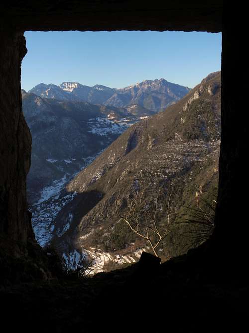
First tunnel's slit dominating Val di Ledro |
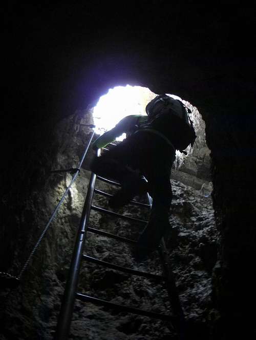
First WWI tunnel exit ladder- |
War trench near the summit |
We enter the winding tunnel with several and small panoramic multidirectional windows and following the signposts we head to right to reach the exit of the tunnel. A 12 meters metal vertical ladder, equipped with a safety rope, leads us out of the tunnel. Now we climb inside the wood some steep steps, well equipped with an iron rope, quickly reaching the entrance of the second tunnel, this second one shows other several panoramic multidirectional slits. Following the signposts inside the tunnel we exit this latter, reaching a nice terrace giving breathtaking views. After a short climb, we reach the entrance of the third and last tunnel. We’ll enter it later, now we follow the path 417a to reach the superb summit of Cima Rocca. This path follows an old war trench lying along the summit crest, reaching the summit cross (summit book, 2 hours from Biacesa). From the top you can enjoy a superb view of Garda Lake and the confluence of the river Sarca and the many surrounding peaks, such as Monte Stivo, Bondone with its three summits, Monte Altissimo di Nago and below us the summit of Cima Capi. Westward numerous peaks of the Ledro Alps appear.
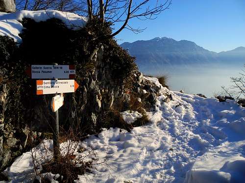
Signposts near the third tunnel |
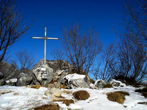
Summit |
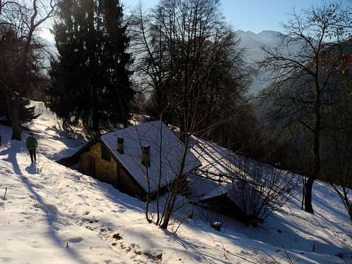
Malga Vasotina |
Descent - We retrace on our steps, descending to the entrance of the 300 meters tunnel completely dark and we enter it, walking inside equipped with a head torch. After exiting the tunnel, we walk inside the shady trenches located on the northern side of the mountain in the direction of Bocca Pasumer and without reaching it, in view of a large electricity pylon, we take the left path n. 460/b, which drops down in the wood reaching the magnificent Malga Vasotina or Malga Degiacomi m. 960. The trail reaches two consecutive crossroads, in the vicinity of which we always keep the left, reaching the path n. 460 just below the Church of San Giovanni. In the last part of the descent we follow the reverse path of ascent, leading to Biacesa.
Essential gear
Via Ferrata set, helmet, a head torch - In wintertime, according with the conditions, crampons and axe may be useful.
Red Tape
No permits, no fees required
Hiking grades of difficulty
T - Turistico (Tourist): Itineraries on wide, clear and well worn paths, sometimes on mule tracks or gravel roads. The routes are never exposed, don't give any orientation problems and don't exceed 2500 meters of altitude. Suitable also for children
E - Escursionisti (Hikers): Itineraries on marked trails, even narrow and with possible steep and impervious sections. They are never exposed and don't give any orientation problems. They can tread different kinds of ground, such as forests, gravel, meadows, pastures, easy rocks, etc.). They form the majority of the trails that wind up in the mountains and require a certain habit to walk; you need equipment suitable for the altitude and resistant footwear with soles suitable for rough terrain
EE - Escursionisti Esperti (Experienced Hikers): Itineraries for hikers with experience and good knowledge of the mountain. Some of these paths may have exposed sections, however brief, which require firm foot and no dizziness. They require the ability to adapt to particular terrain, such as steep grassy slopes or stretches of rocks with difficulties that can reach the 1st degree of the UIAA scale. They can also reach high altitudes (3000 m or more). Sometimes they may include unmarked sections, requiring a good sense of orientation. Snow slopes are possible, however which can be overcome without specific mountaineering gear (rope, harness, crampons, ice-axe)
EEA - Escursionisti Esperti con Attrezzatura (Experienced Hikers with equipment - The same as EE, in addition these routes require the use of via ferrata equipment (lanyards, harness, carabiners, heat sink, helmet). This kind of itineraries range from the trails with short easy and not much exposed sections, previously equipped with fixed ropes and iron pegs, to the true and more difficult Via Ferratas climbing on rocky walls or on aerial ridges and ledges, previously equipped with long stretches of iron ropes, iron steps, ladders without which proceeding would constitute a real climbing. It is necessary to know how to use the technical equipment and have a certain habit of exposure and mountaineering terrains.
When to Climb
All year round
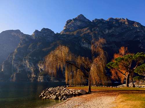
Cima Rocca seen from Riva del Garda |

Biacesa di Ledro, start of the route |
View from the summit |
Accomodation
Several possibilities of accomodation in Val di Ledro and Riva del Garda
Bibliography
"Prealpi Bresciane e Gardesane" - Fausto Camerini - Collana Guide dei Monti d'Italia CAI-TCI
Map: KOMPASS sheeet 071 – Alpi di Ledro Valli Giudicarie 1:50.000