
|
|
Mountain/Rock |
|---|---|
|
|
45.90569°N / 10.76912°E |
|
|
Trentino Alto-Adige |
|
|
Hiking, Scrambling |
|
|
Spring, Summer, Fall, Winter |
|
|
5912 ft / 1802 m |
|
|
Overview
PAGINA CON TRADUZIONE IN LINGUA ITALIANA - PAGE WITH TRANSLATION INTO ITALIAN LANGUAGE
Cima d'Oro m. 1802
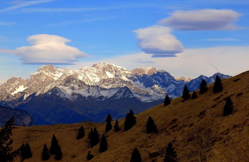
Cima d’Oro 1802 m is a montain belonging to the Prealpi Bresciane and Gardesane, sector Alpi di Ledro, Subgroup Catena di Pichea, and located above the Lago di Ledro in the homonymous valley. It's a little-known mountain, also called Cima dei Marasch, located to the South of Cima Parì and between Bocca Dromaè 1680 m to the North and Bocca Giumella 1410 m to the South. On the summit there's just a small cairn, while on the Southern rocky fore-summit at the altitude of 1703 m it was built a high cross visible from Molina di Ledro. From this fore-summit it starts a complex of still well visible trenches both along the S ridge and the WSW one, called Costa di Salò. In effect, like the majority of the mountains located around Garda lake, Cima d’Oro was directly involved in the World War I fighting, during which on these mountains the Italian army faced the Austro-Hungarians. Remains of barracks, trenches and caves are numerous, even along the summit ridge: another reason of interest to climb Cima d'Oro. Cima d'Oro was an important outpost of the Austro-Hungarian army; the cross is located on the foresummit m. 1703, to the South of the main summit, which has a beautiful panoramic terrace projected over Lago di Ledro. On this foresummit there were the observatory, a powerful projector, beating the lake and rocky ridges and many gun emplacements. The most advisable route to the summit is the beautiful Austro-Hungarian Trail from the West, passing through the Coste di Salò. It combines the beauty of the route to a vast landscape, that is truly exceptional in reason of the central position of the mountain, extending itself from the Verona plain to the pre-Alpine peaks located around Laghi di Garda and Ledro, the Sella group, the Brenta Dolomites and the high icy peaks of the Adamello-Presanella groups.
Cima d'Oro m. 1802 è una montagna appartenente alle Prealpi Bresciane, settore Alpi di Ledro, sottogruppo Catena di Pichea, e domina il Lago di Ledro nell'omonima valle. È una montagna poco conosciuta, chiamata anche Cima dei Marasch, situata a sud di Cima Parì e tra Bocca Dromaè 1680 m, a nord, e Bocca Giumella 1410 m a sud. Sulla sommità c'è solo un piccolo ometto, mentre sul versante roccioso meridionale a 1703 m di altezza (anticima) venne costruita un'alta croce ben visibile da Molina di Ledro. Da questa prima sommità inizia un complesso di trincee ancora ben visibili sia lungo la cresta S che quella WSW, chiamata Costa di Salò. In effetti, come la maggior parte delle montagne situate intorno al lago di Garda, la Cima d'Oro fu direttamente coinvolta nellle vicende della Prima Guerra mondiale, durante la quale su queste montagne l'esercito italiano affrontò gli austro-ungarici. Resti di caserme, trincee e grotte sono numerosi, anche lungo la cresta sommitale: un altro motivo di interesse per salire su Cima d'Oro.
La Cima d'Oro era un importante avamposto dell'esercito austro-ungarico; la croce si trova sull'anticima a 1703 metri di quota, a sud della cima principale, che ha una bella terrazza panoramica proiettata sul Lago di Ledro. Su questa anticima erano situati l'osservatorio e un potente proiettore, che batteva il lago, le creste rocciose e molte postazioni di artiglieria. Il percorso più consigliabile per raggiungere la vetta è il bellissimo Sentiero Austro-ungarico da ovest, passando per le Coste di Salò. Combina la bellezza del percorso a un vasto panorama, davvero eccezionale in ragione della posizione centrale della montagna, panorama che spazia dalla pianura veronese alle vette prealpine situate attorno a Laghi di Garda e Ledro, il gruppo del Sella, le Dolomiti di Brenta e le alte cime ghiacciate dei gruppi Adamello-Presanella.

 and Adamello range (in the background)")
Getting There
The starting point to climb the mountain is Mezzolago, Alla Valle m. 850
Access to Mezzolago
From the Brennero highway exit Rovereto Sud and take the road to Riva del Garda. From here follow the road to Val di Ledro. After driving through two long tunnels we enter the narrow Val di Ledro. We pass the village of Biacesa reaching Lago di Ledro just in Molina di Ledro. The road continues along the Northern shore of the lake, reaching the small village of Mezzolago. We leave the main road and turn to right on a narrow asphalt road with a signpost indicating "Bed and Breakfast". The road passes the last houses of Mezzolago and rises up the valley as far as the ban that prohibits the further continuation by car (resort Alla Valle - altitude about 820 m). Parking lot.
Il punto di partenza per la salita è la località Alla Valle, Mezzolago 850 m
Dall'autostrada del Brennero uscire a Rovereto Sud e prendere la strada per Riva del Garda. Da qui si segue la strada per la Val di Ledro. Dopo aver attraversato due lunghe gallerie entriamo nella stretta Val di Ledro. Superiamo il paese di Biacesa raggiungendo il Lago di Ledro proprio in località Molina di Ledro. La strada prosegue lungo la sponda settentrionale del lago, raggiungendo il piccolo borgo di Mezzolago. Lasciamo la strada principale e svoltiamo a destra su una stradina asfaltata con un cartello che indica "Bed and Breakfast". La strada supera le ultime case di Mezzolago e risale la valle fino al divieto che vieta l'ulteriore prosecuzione in auto (località Alla Valle - quota 820 m circa). Parcheggio.
Route: "Austro-Hungarian War Trail"
Monte d'Oro via the "Botanical Trail" and the "Austro-Hungarian War Trail"
Summit quote: 1802 m
Difficulty: E
Difference in level: 980 m from Alla Valle
Exposition: West
Time required: 5 hours round trip
Starting point: locality Alla Valle m 823


Route description
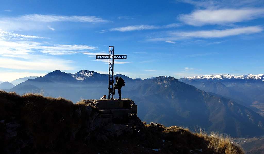
We begin to walk along the forest road following the signs "Botanical trail Cima d'Oro". We keep it for a few minutes meeting soon a fork to the left. We leave the wide gravel road and take the steep path still marked with the signposts "Botanical Trail". The path rises into the thick of the forest in a cool and shady setting. In moderate slope we walk on the trail intersecting the forest road previously ignored. It's important to tell that the path allows so much more direct to cut the bends going up the steep wooded hillside. Getting to the last intersection with the forest road follow this latter to the left, getting soon to a panoramic terrace with tables and signpost. A little further you leave the forest road again to take on the right the Austro-Hungarian Warpath, indicated with blue and white marks. At first the path remains in the wood, here it's possible to see on the right various ambushes and caves built as observation points during the First World War. Then the trail gains the crest, where the view opens out spectacularly over the underlying Lago di Ledro and to the West over the southern sector of the Adamello Group. The war trenches, at times steep, are obvious and perfectly walkable. As we continue, the trail leads to the entrance of an artificial war-tunnel with steep steps. A second war gallery is avoided and our trail rises along a steep narrow trench, after which it appears what at first seems to be the top of Cima d'Oro with a huge summit cross.


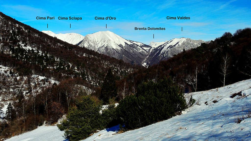
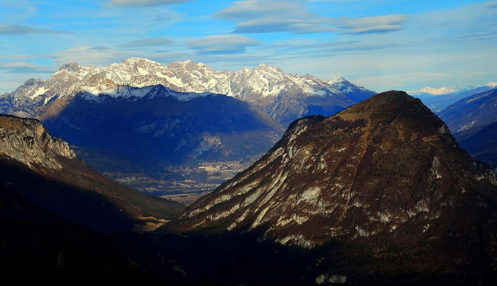
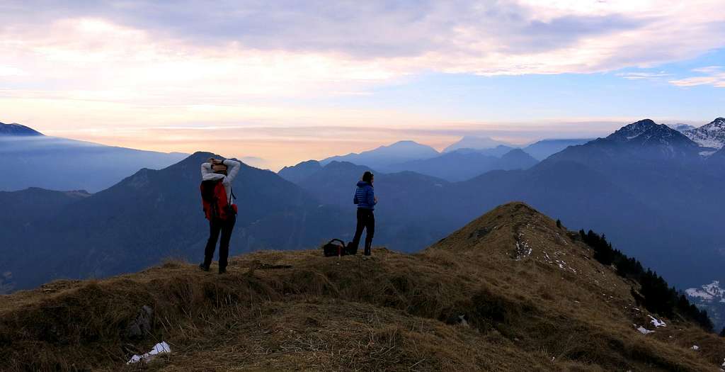
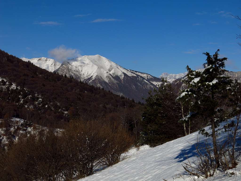
We are instead in front of the foresummit at 1702 meters, a platform projected towards the South with breathtaking views over Lago di Ledro, the Southern Garda summits and Southern Adamello again (summit book - 2.10 hours from the parking lot). Eastwards it appears also the Garda Lake. To reach the highest point of the Cima d'Oro now it requires navigating on a nice grassy ridge along which is dug a long trench war. The trail runs just to the right of the trench and here the absence of trees allows to enjoy an exceptionally wide view also to the North, with the magnificent Brenta Dolomites, the peaks surrounding Sarca Valley, Paganella and farther to the right the Dolomites. From the foresummit the highest point (1.802 m, about 2.30 hours from the parking lot) is briefly climbed. Countless peaks are quite visible, Monte Tremalzo and Monte Corno, Cima Parì and Sclapa nearby and an unmistakable profile of Monte Cadria, Carè Alto, Mazza and Corni di Pichea.
Iniziamo a camminare lungo la strada forestale seguendo le indicazioni "Sentiero botanico Cima d'Oro". La seguiamo per alcuni minuti incontrando quasi subito un bivio a sinistra. Lasciamo l'ampia strada sterrata e prendiamo il sentiero ripido ma ben segnato con le indicazioni "Sentiero botanico". Il sentiero sale nel folto della foresta in ambiente fresco e ombreggiato. In pendenza moderata camminiamo sul sentiero intersecando la strada forestale precedentemente lasciata. Il sentiero consente spesso di incrociare la forestale salendo più ripido lungo il pendio boscoso. Raggiunto l'ultimo incrocio con la strada forestale si prende quest'ultima verso sinistra, raggiungendo presto una terrazza panoramica con tavoli e tabelle. Un po 'più avanti si lascia nuovamente la strada forestale per prendere a destra il Sentiero di guerra Austro-ungarico, indicato con segni blu e bianchi. All'inizio il sentiero rimane nel bosco, qui è possibile vedere sulla destra vari nascondigli e grotte costruite come punti di osservazione durante la Prima guerra mondiale. In seguito il sentiero raggiunge la cresta dove la vista si apre in modo spettacolare sul sottostante Lago di Ledro e ad ovest sul settore meridionale del Gruppo dell'Adamello. Le trincee di guerra, a volte ripide, sono ben evidenti e perfettamente percorribili. Mentre proseguiamo, il sentiero conduce all'ingresso di un tunnel di guerra artificiale con ripidi gradini. Si evita una seconda galleria di guerra e il nostro sentiero sale lungo una ripida e stretta trincea, dopo di che appare ciò che a prima vista sembra essere la vetta della Cima d'Oro con un'enorme croce di vetta.
Siamo invece di fronte all'anticima di 1702 metri di altezza, una specie di piattaforma proiettata verso sud con vista mozzafiato sul Lago di Ledro, le cime del Garda Meridionale e l'Adamello meridionale (libro di vetta, 2.10 ore dal parcheggio). Verso est appare anche il Lago di Garda. Per raggiungere il punto più alto della montagna è necessario risalire un bel costone erboso lungo il quale è situata una nuova lunga guerra di trincea. Il sentiero risale proprio a destra della trincea. Qui l'assenza di vegetazione permette di godere di una vista eccezionalmente ampia anche verso Nord, con le magnifiche Dolomiti di Brenta, le vette che circondano la Valle del Sarca, la Paganella e più a destra le Dolomiti. Dall'anticima si raggiunge in breve il punto culminante (1.802 m, circa 2.30 ore dal parcheggio). Innumerevoli le cime visibili, Monte Tremalzo e Monte Corno, Cima Parì e Sclapa nelle vicinanze e il profilo inconfondibile di Monte Cadria, Carè Alto, Mazza e Corni di Pichea.
Descent: reversing the route. Anyhow the best advise is another option that allows you to make a round-trip: continue on the summit crest towards NW, descent to Val Dromaè passing nearby the homonym alps and then follow a well worn path leading on the lower section of the Austro-Hungarian War-Trail and the panoramic terrace, from which reversing the ascent route.
Discesa: si segue lo stesso itinerario, ma la soluzione più consigliabile, che permette di compiere un anello, è proseguire sulla cresta sommitale verso NW, scendere in Val Dromaè passando vicino all'omonimo alpeggio e poi seguire un sentiero ben tracciato che si innesta sulla parte bassa del Sentiero Austro-Ungarico e raggiunge così la terrazza panoramica, da dove si rientra seguendo l'itinerario di salita.
")

Essential gear
In wintertime, according with the conditions, crampons and axe are needed.
In inverno, a seconda delle condizioni, sono necessari ramponi e piccozza.
Other routes
- NNW ridge
- From East
Red Tape
No fees no permits required. Cars are not allowed beyond the ban at the altitude of 850 meters.
Non sono necessari permessi o tasse d'ingresso. Divieto di accesso alle auto a quota 850 metri circa
Accomodation
Several possibilities of accomodation in Val di Ledro
Numerose possibilità di pernottamento in tutta la Val di Ledro
When to Climb
All year round – In winter condition the ascent requires the use of axe and crampons
Tutto l'anno. In inverno l'ascensione alla cima può richiedere piccozza e ramponi a seconda delle condizioni di innevamento.
Bibliography
"Prealpi Bresciane" by Fausto Camerini - Collana Guide dei Monti d'Italia, CAI-TCI
"Guida alle Alpi di Ledro" by F. Torchio - E. Gardumi, Panorama, Trento, 1995
Maps
"Alpi di Ledro - Tremalzo" - LagirAlpina sheet 16 - 1:25.000
"Alpi di Ledro Valli Giudicarie" - KOMPASS sheeet 071 – 1:50.000
"Garda-Trentino" map scale 1:30.000
Meteo Forecast
Meteo arpalombardia
Meteo Trentino