
-
 2165 Hits
-
 83.1% Score
-
 16 Votes
|
|
Mountain/Rock |
|---|---|
|
|
45.50364°N / 7.10657°E |
|
|
Mountaineering |
|
|
9921 ft / 3024 m |
|
|
Overview
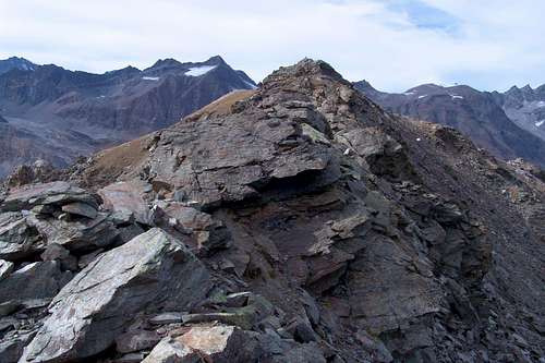
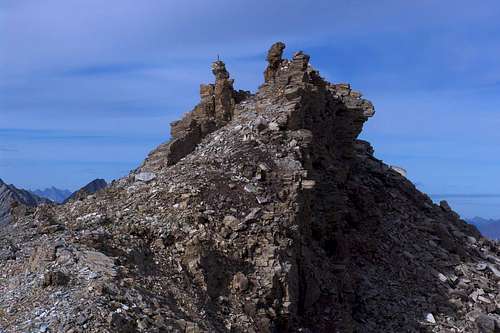
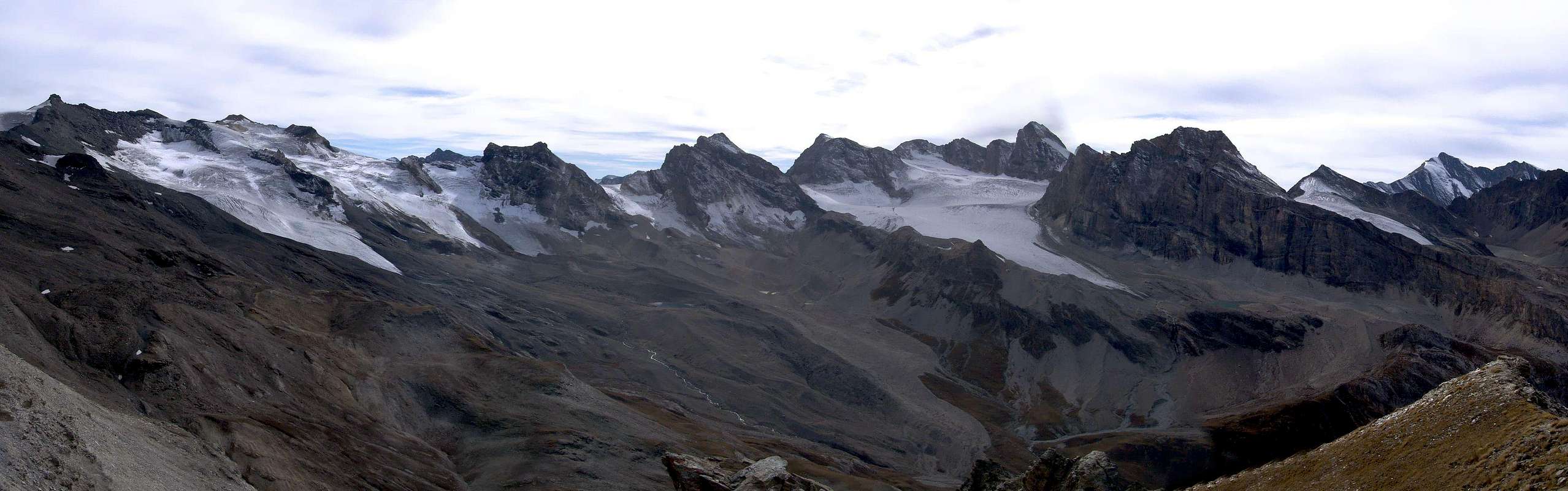
We add that of Rhêmes for to distinguish this Summit, which is (2.810m) located in the valley, and just above the refuge Federico Benevolo, from an other with same name as the one located between Punta Leissé and the Monte Rosso in the Group of Mont Fallère. Placed on the continuation of the ridge Northwest of Gran Vaudala (3.272m) it is formed by two distinct Summit of which is the South, even if only slightly, the highest (3.024m, 2.981m). A wide saddle between the 2.968 and 3.090 meters divides also forming the Southwest edge of the small glacier Grand Vaudalaz at the apex of the eponymous vallon, secondary to the East in respect the valley floor. From Punta Nord watershed however, bending more to the North, reached the Pointe de Lavassey (2.772m) last elevation above the Refuge Federico Benevolo (2.237m) and the alp of the same name. A simple but never boring crossing that allows panoramic hike somewhat, as already indicated in "Guide of the Western Alps", in 1896 by Giovanni Bobba and Luigi Vaccarone, renowned and real famous mountaineers-writers of Turin, on page 140: "It has a very nice view on the whole basin terminal of the Valley Rhêmes ... ". In addition, we add, stunning views to the Northwest on the large and impressive Eastern Wall of the Grande Rousse and beautiful shots eye on the nearby Gran Vaudala or, for the inhabitants, the Grand Vaudalaz.
Aggiungiamo quel di Rhêmes per distinguere questa Sommità, che si trova nell'omonima valle ed appena al di sopra del Rifugio Federico Benevolo, da altre omonime come quella (2.810 m) sita tra la Punta Leissé ed il Monte Rosso nel Gruppo del Mont Fallère. Collocata sul proseguimento della Cresta Nordovest della Gran Vaudala (3.272 m) è formata da due Sommità ben distinte delle quali quella Meridionale risulta, anche se di poco, la più elevata (3.024 m, 2.981 m). Una larga sella tra i 2.968 e 3.090 metri le divide costituendo anche il margine Sudoccidentale del piccolo Ghiacciaio della Grand Vaudalaz all'apice dell’omonimo vallone, secondario ad Oriente rispetto al fondovalle. Dalla Punta Settentrionale lo spartiacque invece, flettendo maggiormente a Settentrione, raggiunge la Pointe de Lavassey (2.772 m) ultima elevazione sopra il Rifugio Federico Benevolo, nonché l'omonima alpe. Una facile ma mai banale traversata, che permette un'escursione alquanto panoramica, come già segnalato in "Guida delle Alpi Occidentali", 1896 di Giovanni Bobba e Luigi Vaccarone, rinomati e famosissimi alpinisti-scrittori torinesi, a pagina 140: "Offre un panorama bellissimo su tutto il bacino terminale della Valle di Rhêmes …". Inoltre, aggiungiamo noi, splendide vedute verso Nordovest sulla grande Parete Orientale della Grande Rousse e bei colpi di occhio sulla vicina Gran Vaudala o localmente anche Grand Vaudalaz.
 |
 |
First Ascents
- First on the Summit: Unknown.
- In winter: Unknown.
Getting There
BY CAR:- From France: through the Mont Blanc Tunnel or the Col du Petit Saint Bernard: you can drive on SS.26, following directions for Aosta and, before arriving in Villeneuve, turn right towards Introd. Alternatively, you can take Motorway A5 (at Courmayeur or Morgex) and exit at Aosta Ovest.
- From all the other directions: get to the Aosta Ovest exit of Motorway A5. Then drive on SS.26 Aosta, in the direction of Courmayeur; just after Villeneuve turn left towards Introd.
BY PLANE:
- Aeroporto "Corrado Gex" Saint Christophe (Aosta).
![]()
Approach
From the wide parking in soil (1.848m), in West from the Doire de Rhêmes, continue in South through the road again in asphalt towards the upper Pasture (1.901m), leaving, just before, left that descending to of Thumel little Village (1.879m). Instead, abandoning right the dirt road, continue South near a fountain with panels and signals through the path n° 13 towards Gian Federico Benevolo Refuge (2.285m). Crossing below the characteristic small Church St. Pantaleon (1.936m) go up by South-southwest direction along and from upper the Rhêmes Doire. Leaving right the deviation to Fos Alp, cross into a small valley the, with same name, small torrent reaching, by more in Southwest route amongst prairies, the following of Saint-Pantaleon (2.010m) and Barmaverain (2.037m). Very soon wade across the torrent reaching the waterfalls in altitude 2.051 meters. By a brief and hardly more steep ascent diagonal, go upper dirt main road and through false level route join at Roman Bridge upon the torrent (about 2.125/30 meters). From this point continue by same road with two narrow hairpin bends to Lavassey Alp (2.227m) also to rejoin by a short cut, at once over the bridge; from pasture by short cut again or by a nearby dirt road reach the shelter, collocated on ample grassy-rocky promontory (E; 1h'20/1h'35).Dal grande parcheggio in terra battuta (1.848 m), affianco ad Occidente al corso della Doire de Rhêmes, proseguire verso Sud con la strada ancora in asfalto fino a raggiungere la soprastante Alpe 1.901 metri, lasciando appena prima a sinistra la deviazione per il Villaggetto di Thumel (1.879 m). Abbandonando invece a destra la continuazione della strada poderale, si continua presso una fontana verso Mezzogiorno con il sentiero n° 13 (indicazioni varie e pannello) che, oltrepassata la Chiesetta di St. Pantaleon (1.936 m), prosegue a Sud-susovest attraversando i prati e passando alto sopra la Doire de Rhêmes, nonché lasciando sulla destra la deviazione per l'Alpeggio di Fos. Quindi, dopo un valloncello, raggiungere le successive Alpi di St. Pantaleon e Barmaverain (2.010 m, 2.037 m; attraverso queste passa anche la strada poderale da Thumel) raggiungendo a quota 2.051 metri una serie di cascate. Da questo punto un corto ed appena più ripido diagonale conduce alla soprastante poderale e subito appresso al Ponte Romano (2.125 metri circa), donde o continuare tramite la medesima, che con due tornanti stretti conduce all'Alpeggio di Lavassey (2.227 m), oppure continuare tramite un sentierino che sale dal ponte raggiungendo la stessa e subito dopo il rifugio, collocato in un vasto promontorio erboso-roccioso (E; 1h'20/1h'35).
 |
 |
 |
 |
 |
Route
From Refuge Federico Benevolo toward Southeast follow the trail n° 13B directed to the Hills Nivoletta and Basei. Arrived at an altitude of about 2.570/80 meters abandon the same and go further to the East in a small valley where the highest is found a pond; from this point bending to the left, first through bumps meadows and then moraines, reaching nearly 3.000 meters the wide saddle on the Ridge Northwest of Gran Vaudala. Continuing easily to the left, but in the opposite direction, along the Southeast Ridge, formed by broken small rocks and blocks to the South-southeast Summit (3.024 m; 2h'00/2h'30 from the refuge; 3h'30/4h'00 directly from Thumel).Dal Rifugio Federico Benevolo seguire verso Sudest il sentiero n° 13B indirizzato verso i Colli di Nivoletta e Basei. Arrivati a quota 2.570/80 metri circa abbandonare il medesimo e risalire più verso Oriente dentro un valloncello al cui sommo trovasi un laghetto; da questo punto flettendo più a sinistra, dapprima tramite dossi prativi e poi morene, raggiungere intorno ai 3.000 metri l'ampia sella sulla Cresta Nordovest della Gran Vandala. Continuando sempre verso sinistra ma in opposta direzione percorrere la facile Cresta Sudest, formata da roccette rotte e blocchi insino alla Sommità Sud-sudest (3.024 m; 2h'00/2h'30 dal rifugio; 3h'30/4h'00 direttamente dal Thumel).
Difficulties
The route is rated EE; from F to F+.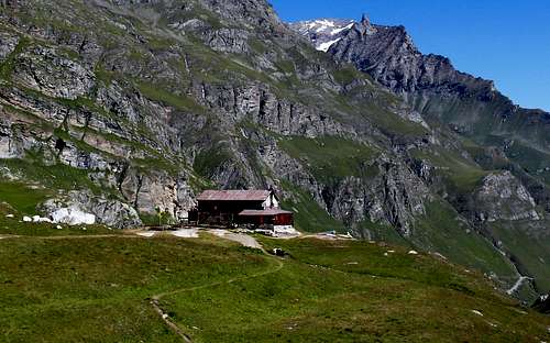
Red Tape
The Eastern side of the valley belongs to Gran Paradiso National park, the Western one is out of the boundaries of the Park ... but nature must be respected.
Campings
Remember that free camping is forbidden (except for emergency reasons, over 2.500m, from darkness until dawn).
Mountain Conditions
- You can get meteo information at the official site of the Regione Valle d'Aosta:
- Valle d'Aosta Meteo
- Meteo: You can find more weather information on the website 3B Meteo:
- Meteo Rhemes Notre Dame
Webcam
- WEBCAM on Aosta Valley:
- Webcam
Books and Maps
BOOKS:
- "Guida delle Alpi Occidentali" di Giovanni Bobba e Luigi Vaccarone C.A.I. Sezione di Torino Volume II (parte II), 25 Maggio 1896.
- "Guida dei Monti d'Italia-Gran Paradiso Parco Nazionale" E. Andreis, R. Chabod, M. C. Santis, Club Alpino Italiano/Touring Club Italiano, prima Ed. 1939; seconda Ed. 1963; terza Ed.
- "Guida della Regione Autonoma Valle d'Aosta" di Mario Aldrovandi,Ed. S.P.E. di Carlo Fanton, Torino 31 Dicembre 1964.
- "Rifugi e bivacchi in Valle d'Aosta", di Cosimo Zappelli aggiornata da Pietro Giglio, Musumeci Editore, Luglio 2002.
- "Diari Alpinistici" di Osvaldo Cardellina e Indice Generale accompagnato da Schedario Relazioni Ascensioni 1964-2019 (inediti).
- "80 itinerari di Escursionismo Alpinismo e Sci Alpinismo in Valle d'Aosta", di Osvaldo Cardellina, Ed. Musumeci, Giugno 1977 (in Italian); seconda Ed. Luglio 1981; terza Ed. Luglio 1984; (in French), prima Ed. Febbraio 1978; seconda Ed. Marzo 1980.
 |
 |
 |
 |
 |
MAPS:
- Kompass "Gran Paradiso Valle d'Aosta Sentieri e Rifugi" Carta Turistica 1:50.000.
- Enrico Editore Ivrea-Aosta "Gruppo del Gran Paradiso" 1:50.000.
- I.G.C. Istituto Geografico Centrale Carta dei sentieri e dei rifugi "Valsavarenche-Val di Rhêmes-Valgrisenche" 1:25.000.
Important Information
- REGIONE AUTONOMA VALLE D'AOSTA the official site.
- FONDAZIONE MONTAGNA SICURA Villa Cameron, località Villard de la Palud n° 1 Courmayeur (AO) Tel: 39 0165 897602 - Fax: 39 0165 897647.
- SOCIETA' GUIDE ALPINE DEL GRAN PARADISO Comune di Valsavarenche.
- A.I.NE.VA. (Associazione Interregionale Neve e Valanghe).
Useful Numbers
- Protezione Civile Valdostana località Aeroporto n° 7/A Saint Christophe (Ao) Tel. 0165-238222.
- Bollettino Meteo (weather info) Tel. 0165-44113.
- Unità Operativa di Soccorso Sanitario Tel. 118.