
-
 3451 Hits
-
 84.27% Score
-
 18 Votes
|
|
Mountain/Rock |
|---|---|
|
|
45.57481°N / 7.36036°E |
|
|
Mountaineering |
|
|
10016 ft / 3053 m |
|
|
Overview
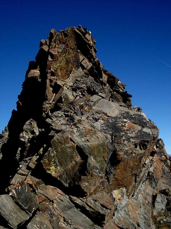
This small pyramid is located near the end of the long watershed that, coming from the Chain of the Apostles starting by the Gran San Pietro, divides the valleys of Valeille (to the East) and Valnontey on the opposite side, dominating the Municipality of Cogne and the adjoining Hamlet of Lillaz. Not very busy though almost exclusively frequented in the past by hunters of chamoises and ibexes and currently enough popular by the people on-site, offers beautiful views of the whole area of the Commune of Cogne. The only mountaineering route, also used for a more rapid descent, is located on the steep Slope Northwest and was realized in 1937. The others are hiking trips, here such as the one recommended and is the one described, or through the Slope Northeastern and short South-southeast small Crest in the terminal stretch from Colle di Grandzetta on the watershed with the below Valnontey.
|

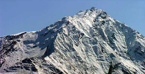
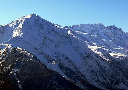
From left: Punta della Sengie (3.408m), Punta Ondezana (3.492m), Torre di S. Orso (3.618m), Punte Patrì (3.581m), Punta di Valmiana (3.244m) and Punta Fenilia (3.053m).
Questa piccola piramide é situata quasi al termine del lungo spartiacque che, provenendo dalla Catena degli Apostoli e a partire dalla Sommità del Gran San Pietro, divide le Valli di Valeille (ad Est) e di Valnontey sul lato opposto, dominando il Comune di Cogne e l'attigua Frazione di Lillaz. Non molto frequentata se non nel passato dai Cacciatori di camosci e stambecchi ed attualmente dagli abitanti in loco, offre delle belle vedute su tutto il comprensorio del Comune di Cogne. L'unica via alpinistica, utilizzata anche per una discesa più rapida, si trova sul ripido Versante Nordovest ed è stata realizzata nell'estate del 1937. Le altre sono gite e mete escursionistiche, tra le quali l'unica consigliata risulta quella qui descritta, ovvero tramite il Versante Nordorientale e la breve crestina Sud-sudest nel tratto terminale dal Colle di Grandzetta sullo spartiacque con la sottostante Valnontey.
First Ascents
- First on the Summit: Unknown.
- In winter: Unknown.
- Northwest Slope: P. Malvezzi and G. Gerard, (Jul 21th, 1935), in ascent from Valnontey.

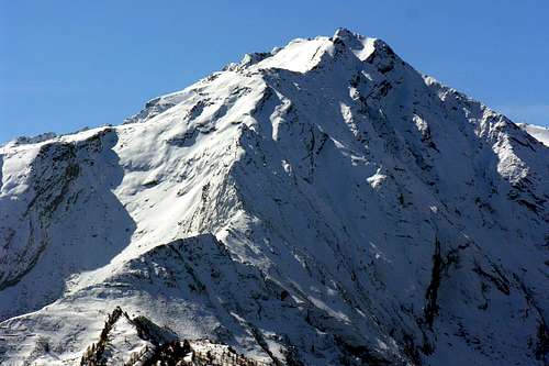
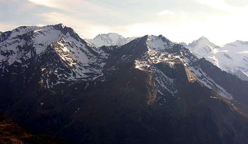
summit of Punta Fenilia 3.053m, Valnontey side
Getting There
BY CAR:
- From Torino, Milano, etc: Motorway A5. Exit at Aosta Ovest. Drive to the near Aymavilles. Follow the directions for Valle di Cogne.
- From Switzerland: through the Grand Saint Bernard Tunnel or the namesake Pass. Drive to Aosta, then follow the direction for Courmayeur on SS.26. Just after Sarre, turn to the left, in the direction of Valle di Cogne.
- From France: through Mont Blanc Tunnel or Petit St. Bernard Pass. It isn't necessary to take Motorway A5: you can drive on SS.26, in the direction of Aosta. Before arriving at the Village of Sarre, turn right following the sign for Valle di Cogne. After Aymavilles, the SR.47 crosses the Villages of Vieyes, Epinel and Cretaz and after about 25 Km arrives at Cogne (1.534m).
- From Courmayeur Resort: in East-southeast to Aosta West near Aymavilles Common; from this, passing Vieyes, Epinel and Cétaz Hamlets, until Cogne Municipality and Lillaz Fraction.
- From Aosta City in West towards Aymavilles Commune; from this up to the Cogne Common and Lillaz Hamlet.
BY PLANE:
- Aeroporto "Corrado Gex" Saint Christophe (Aosta).

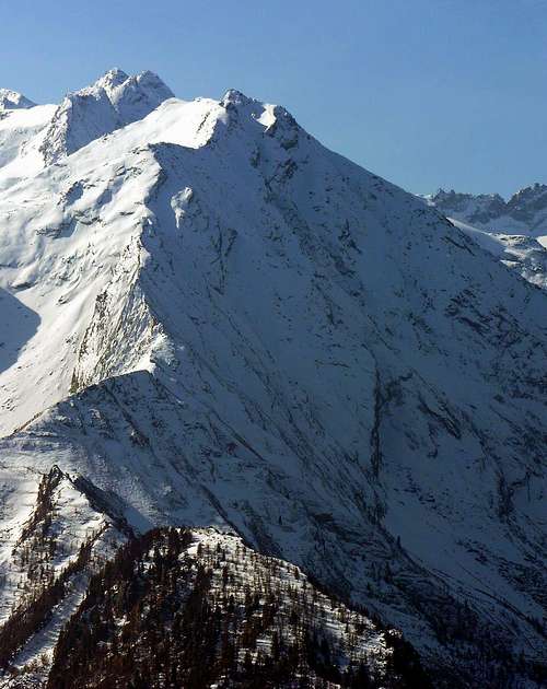
At the foot of Punta Fenilia 3.053m: view from Baben, near the hamlet of Valnontey
Approach and Route
From Lillaz Hamlet towards the junction 2.350 meters and Punta Fenilia (3.053m) long easy excursion with n° 16 in Southwest to the following alternative 2.350 meters (here even through a path always n° 16 but with more large tour to the West and starting by Cogne Commune) and from fork through a small unnumbered path to Fenilia, passing below the Pointe de Vigeusaz up to the altitude of 2.812 meters. From this point to reach, along moraines and blocks, the watershed with the Valnontey at the Col Grandzetta (3.049m) and from this conclude with the easy Crest South-southeast (E/F; 0h'30 by Grandzetta Pass; 3h'45/4h'15 from Lillaz Hamlet; 4h'30/4h'45 from Cogne).
Dalla Frazione di Lillaz in direzione del bivio 2.350 metri e della Punta Fenilia (3.053 m) tramite lunga ma facile escursione con il sentiero n° 16 a Sudovest sino a raggiungere il successivo bivio 2.350 metri (qui inoltre anche per mezzo del sentiero sempre n° 16 ma con più largo giro verso Ovest e con partenza dal Comune di Cogne) e dalla diramazione tramite sentierino non numerato alla Punta Fenilia, passando al di sotto della Pointe de Vigeusaz fino alla quota di 2.812 metri. Da questo punto raggiungere, percorrendo morene alternate a blocchi rocciosi, lo spartiacque con la Valnontey presso il Col Grandzetta (3.049 m) e da questo concludere con la facile Cresta Sud-sudest (E/F; 0h'30 dal Colle Grandzetta; 3h'45/4h'15 dalla Frazione di Lillaz; 4h'30/4h'45 da Cogne).
Difficulties
The route is classified F.
Da escursionismo.
MAPS:
Camping
- Wild camping in the Parco Nazionale del Gran Paradiso is strictly forbidden!!!
 |
 |
 |
 |
 |
Mountain Condition
- Meteo: you can find all the needed informations at the official site of the Valle d'Aosta Region:
- Valle d'Aosta Meteo
Webcam
- WEBCAM on Aosta Valley:
- Webcam
Red Tape
Within the borders of the P.N.G.P. (Parco Nazionale del Gran Paradiso), at the moment (summer 2004), dogs generally are not allowed, except on a couple of trails, and camping is forbidden (except for climbers from sunset till dawn). No fees are due.Books and Maps
BOOKS:- "Guida delle Alpi Occidentali" di Giovanni Bobba e Luigi Vaccarone C.A.I. Sezione di Torino Volume II° (parte II) 25-05-1896.
- "Guida dei Monti d'Italia-Gran Paradiso Parco Nazionale" E. Andreis, R. Chabod, M. C. Santis, Club Alpino Italiano/Touring Club Italiano, prima Ed. 1939; seconda Ed. 1963; terza Ed. 1980.
- "Il Parco Nazionale del Gran Paradiso (Valli di Champorcher-Clavalitè-Saint Marcel-Laures-Cogne-Valsavarenche-Conca di Pila" di Giulio Berutto 3/volume 2°, IGC, Torino 1981, 2a Ed. 2000.
- "Gran Paradiso - Itinerari Alpinistici e sci Alpinistici" di Franco Brevini Ed. Musumeci, Giugno 1982.
 |
 |
 |
- Kompass - "Gran Paradiso Valle d'Aosta Sentieri e Rifugi" Carta Turistica 1:50.000.
- Enrico Editore Ivrea-Aosta – "Gruppo del Gran Paradiso" 1:50.000.
- I.G.C. Istituto Geografico Centrale Torino "Gran Paradiso-La Grivola-Cogne" 1:25.000.
- A.I.A.T. "Cogne Gran Paradiso Aymavilles - Walking Map" 1:25.000.
- I.G.C. Istituto Geografico Centrale Torino "Il Parco Nazionale del Gran Paradiso" (3) 1:50.000.
- L'Escursionista "Valle di Cogne Carta dei Sentieri" (n°10) 1:25.000.
- L'Escursionista "Tour de la Vallée de Cogne Grand Paradis" Carta dei sentieri 1:25.000.
Important Information
- REGIONE AUTONOMA VALLE D'AOSTA the official site.
- FONDAZIONE MONTAGNA SICURA Villa Cameron, località Villard de la Palud n° 1 Courmayeur (AO) Tel: 39 0165 897602 - Fax: 39 0165 897647.
- SOCIETA' GUIDE ALPINE DI COGNE Tel. 347/9473526 – 328/1373728.
- A.I.NE.VA. (Associazione Interregionale Neve e Valanghe).
- A.IA.T. Cogne Gran Paradis via Bourgeois n° 34 Tel. 0165-74040. E-mail: aiat@cogne.org
- Ezio Sport articoli sportivi - via Bourgeois n° 64 Tel. 0165-74204.
Useful Numbers
- Soccorso Alpino Cogne (SAR) Tel. 3482685406.
- Protezione Civile Valdostana località Aeroporto n° 7/A Saint Christophe (Ao) Tel. 0165-238222.
- Bollettino Meteo (weather info) Tel. 0165-44113.
- Unità Operativa di Soccorso Sanitario Tel. 118.