
-
 5034 Hits
-
 85.36% Score
-
 20 Votes
|
|
Mountain/Rock |
|---|---|
|
|
44.66101°N / 6.95764°E |
|
|
Piedmont-Queyras |
|
|
Mountaineering, Trad Climbing, Sport Climbing, Scrambling |
|
|
Summer |
|
|
10052 ft / 3064 m |
|
|
Overview
Rocca Bianca 3064 m
Not to be confused with the namesake peak in the Chambeyron Group, Rocca Bianca 3064 m is a beautiful rocky summit, with daring shapes, belonging to the Southern Alpi Cozie, Mongioia subgroup. It's located on the main boundary ridge between Italy and France, in the mountainous area of Colle dell'Agnello, the third highest road col in Europe. Rocca Bianca exact position is between two high cols, the Colle di Saint Véran 2848 m and the Colle Biancetta or Blanchet 2901 m. Colle di Saint Véran is a flat and wide depression between Rocca Bianca and Il Pelvo, a passage frequented by the walkers and connecting Chianale in Valle Varàita on the Italian side with St. Véran on the French side. Colle Biancetta is situated between Rocca Bianca and Roc della Niera, a beautiful pyramid peak called Tete de Toilles by the French alpinists.

Rocca Bianca is a massive mountain of magmatic rocks with two elevations, the North-East summit 3048 m, the lowest, and the South-West summit 3064 m, the tallest. Both the tops are overlaid by a cross and offer a vast and absolutely breathtaking panorama over the surrounding mountains of both sides, on most of the Southern Cozie Alps and on the Alpes-Maritimes.
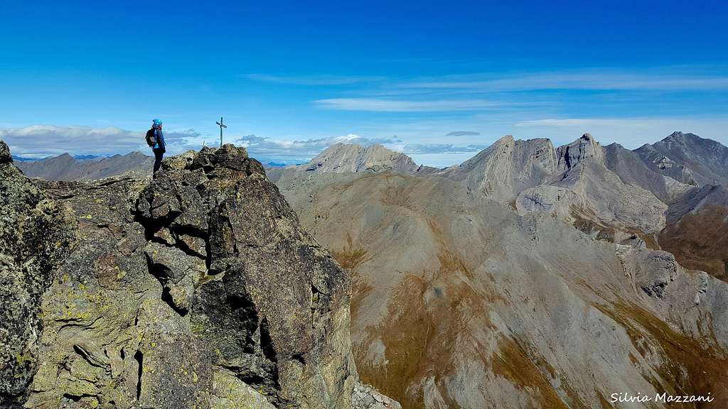
Closer the view widens over the beautiful pyramid of the Roc della Niera and the Pic d'Asti chain, as well as the majestic West wall of the Monviso located right in front. For this reason and also for the ease of access through the Normal route Rocca Bianca is a frequented summit.

|

|
On the side of Chianale (East, Valle Varaita), Rocca Bianca drops with a high wall on which they have been established a couple of challenging traditional climbing itineraries, while on a buttress on the French side near the Refuge de La Blanche some fashionable climbing routes full equipped style have been developed. Near the Colle di San Véran (West side) the mountain opposes a short rocky strip, where it runs the Normal route.

Rocca Bianca Normal route is a very interesting and well-trained itinerary which can be approached both from the Italian side and the French one.
Getting There
Rocca Bianca is usually climbed both from the Italian side and the French one. The Italian Normal route starts from the small and fascinating village of Chianale in the upper Valle Varaita on the road to Colle dell'Agnello, a very high road pass between Valle Varaita on the italian side and Queyras on the French side.

|

|
Road access to Chianale
From the A6 Torino-Savona motorway exit Bra-Marene and take the road to Savigliano, Saluzzo and Valle Varaita (road n. 8). Once you enter the Valle Varaita, drive to Sampeyre and Casteldelfino, overcoming different villages. At the junction in Casteldelfino ignore the left toad to S. Anna di Bellino and take the road on the right to Pontechianale and Chianale, getting to Chianale, the last inhabited village in the valley.
Rocca Bianca Normal Route from Chianale
Rocca Bianca Normal Route from Chianale
Summit altitude: m 3064
Difficulty: Alpine F
Vertical gain: 1110 m from the Rio Antolina bridge
Exposure: East, then North-West
A long worthwhile route inside a spectacular setting! The few difficulties are concentrated in the final part of this itinerary, with some climbing moves grading I UIAA and a short stretch of II below the top. At the beginning of the season when it's still snowy, the climb up the NW rocks becomes slightly more challenging (the presence of ice is possible also after summer snowfalls).

Road approach - From Chianale follow briefly the road to Colle dell'Agnello, then leave the main road and take on the left a road entering Valle Antolina, pass a first parking lot (1809 m) and park your car to the next (1876 m ) near a bridge (signposts to the Col Longet and the Colle of Saint Veran).

|

|
Route report
There's a junction at the parking lot near the bridge, take the gravel road that goes over the concrete bridge on the right toward the Grange Pian Vasserot (path U20, signposts Colle di Saint Véran). Our route follows shortly the dirt road and just before the second hairpin leaves it and turns to right following the signposts for the Colle di Saint Véran (path U20). The mule track, marked by white-red marks, follows the orographic left side of the Saint Véran valley by cutting off the wide grassy slopes above. Further ignore a path on the right to B. Faraudo and shortly after that one to the Carlo Emanuele III shelter. The path continues through the wide valley with superb views to the fine East wall of the Rocca Bianca, overlooking the valley, and to the southwest towards the Laghi di Chianale.

|

|
The itinerary overcomes several drinking water with herds of grazing cows, getting the Grange Cheiron 2441 m; higher up, near a rocky spur, a series of steep bends leads alongside a Madonna placed in a niche. From here you enter the upper part of the valley, reaching the well visible Colle di Saint Veran 2848 m. From the col ignore the main path and turn to left, taking the path towards Colle Biancetta, leading a few hundred meters later on a flat "belvedere". In the next descent we arrive at a fork. Leave on the right the path to Laghi Blanchet and take the left path between the large boulders located at the bit chaotic rocky base of Rocca Bianca NW flank.

|

|
Here it starts the scramble up to get the double summit. The route is marked by some red marks. Let's go straight to a climbing pass with a stuck boulder (grade II UIAA) closing the access. We overcome it and keeping the left we get the entrance of a trench that, after a downhill stretch, rises again to reach the North-East summit 3048 m, exposed on the steep East wall dropping down to the valley. Big cross. We go back a bit on our footsteps and enter a rocky gully leading between large blocks. Continuing to the left by cutting a slope we arrive near a cairn. Turning left, we climb some easy rocks and slabs and the final ridge to the South-West summit 3064 m, the highlight of the Rocca Bianca, where you can admire a horizon-wide show. Small cross. Closer the beautiful piramyd of the Roc de la Niera. Descent: reversing the same route
Other Normal Routes

Alternatively, in order to gain 300 meters of altitude difference, instead of starting from Chianale, you can drive along the road leading to the Colle dell'Agnello up three bends until you reach the foot of a grassy hilltop on which it stands a barracks in ruins (Military Recruiter Carlo Emanuele III, approximately 2200 m). Leave the car at a parking lot on the right. The footpath is on the opposite side of the road and joins the previous route on the Colle di Saint Veran.
Another shorter ascent to Rocca Bianca can be done starting from the Colle dell'Agnello 2744 m, from which the itinerary reachs the Colle St Véran, where it joins the previous route starting from Chianale. See here for the route description (in French): Rocca Bianca from Colle dell'Agnello
Climbing Routes

East wall
On the East wall (Val Varaita side) there are two trad challenging routes getting the NE summit:
- Via del Corso D+, max V+ UIAA (some moves), 200 m
- East wall TD, max V+, 250 m
Some full equipped climbing routes have been established on the French side near the Refuge de La Blanche:
Red Tape
No particulary restrictions in hiking and climbing.
When to Climb
Best season goes from the end of June to middle September.
Accomodation

Italian side
- Rifugio Alevè 1600 m
- Rifugio Savigliano 1743 m
Other kinds of accomodation in upper Valle Varaita: bed and breakfast and agriturismo
French side
- Refuge Agnel 2580 m
- Refuge de la Blanche
Meteo
Meteo Regione Piemonte
Meteo Alpi
Guidebooks and maps
 |
 |
 |
Guidebooks
“Monte Viso – Alpi Cozie Meridionali” by Michelangelo Bruno – Collana CAI-TCI Guide dei Monti d’Italia
“Pays du Viso – Escalade en Queyras entre France et Italie” by Sylvain Pusnel and Guillaume Vallot
Maps
"Monviso-Valle Varaita-Valle Po-Valle Pellice" - IGC sheet 106 1:25000