
-
 24988 Hits
-
 86.3% Score
-
 24 Votes
|
|
Mountain/Rock |
|---|---|
|
|
45.11436°N / 6.56297°E |
|
|
Hiking, Mixed |
|
|
Spring, Summer, Fall |
|
|
10440 ft / 3182 m |
|
|
Overview
Monte Thabor 3178 m
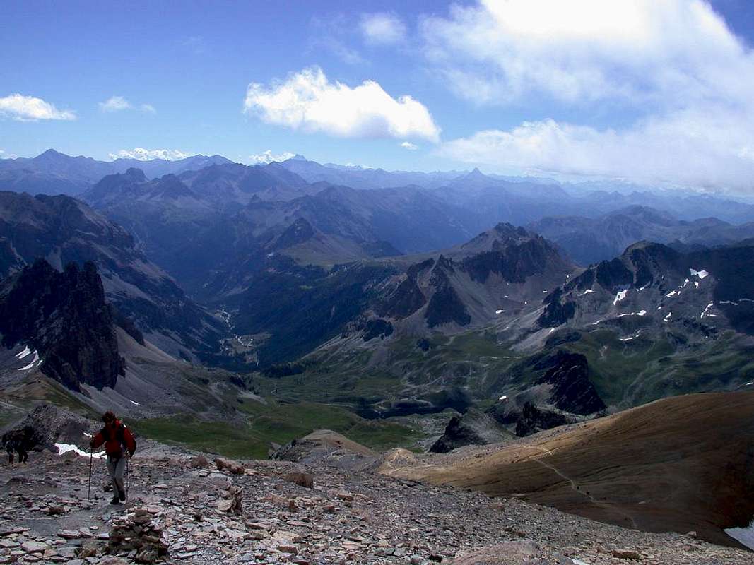
Monte Thabor 3178 m - also written Monte Tabor - is a mountain belonging to the Alpi Cozie and located near the Italy/France border, but entirely in French territory between the departments of Savoy and Hautes-Alpes. Its large and broad summit features a small chapel and offers a magnificent full panoramic view over the Vanoise Massif, the Ecrins Massif, the Queyras and other peaks such as La Meije, Monte Viso, Le Galibier. Despite its altitude that exceeds 3000 meters, the mountain can be reached by following a normal route that doesn't involve any climbing difficulty.

The starting point to summit is the Valle Stretta (Vallée Etroite in French). The peculiarity of this valley belonging to the Western Alps is its situation enclosed between dolomite mountains, a kind of rock difficult to find in the Western Alps. From the start you can see the summit of the mountain, usually covered with snow until the summer, which remains clearly visible in every moment of the ascent. Every year in August there is a pelgrimage to the summit.

|

|
Il Monte Thabor 3178 m - scritto anche Monte Tabor - è una montagna appartenente alle Alpi Cozie e situata vicino al confine tra Italia e Francia, ma interamente in territorio francese tra i dipartimenti della Savoia e delle Hautes Alpes. L'ampia sommità della montagna presenta una piccola cappella e offre una magnifica vista panoramica sul massiccio della Vanoise, il massiccio degli Ecrins, il Queyras e altre cime come La Meije, il Monviso, Le Galibier. Nonostante la sua altitudine superi i 3000 metri, può essere salita seguendo una Via Normale che non comporta difficoltà alpinistiche. Il punto di partenza per la cima è la Valle Stretta (Vallée Etroite in francese). La particolarità di questa valle appartenente alle Alpi Occidentali è la sua posizione racchiusa tra le montagne dall'aspetto dolomitico, un tipo di roccia solitamente difficile da trovare nelle Alpi Occidentali. La cima della montagna è visibile fin dall'inizio dell'ascensione ed è di solito coperta di neve fino all'estate. Rimane chiaramente visibile in ogni momento della salita. Ogni anno in agosto si svolge un pellegrinaggio alla cima.
History
The summit marked the border between Italy and France until 1947. The Treaty of Paris stipulated after the Second World War meant that the upper Valle Stretta passed to France, so the summit now is located in French territories. The name "Thabor" would have been given to this mountain by a pilgrim returning from the Holy Land, in memory of the place of Palestine where the Transfiguration of Christ took place. A chapel, dating back to the 15th century, was erected almost at the top. It still hosts pilgrimages.
La cima della montagna segnò il confine tra Italia e Francia fino al 1947. Il trattato di Parigi stipulato dopo la Seconda Guerra Mondiale assegnò alla Francia l'Alta Valle Stretta, pertanto oggi la vetta si trova interamente in territorio francese. Il nome "Thabor" sarebbe stato dato a questa montagna da un pellegrino di ritorno dalla Terra Santa, in memoria del luogo della Palestina dove avvenne la Trasfigurazione di Cristo. Una cappella, risalente al 15° secolo, fu eretta quasi in cima e ospita ancora alcuni pellegrinaggi.
Getting there
Monte Thabor is best reached from the Valle Stretta (Vallée Etroite). This valley became part of France in 1947, after the World War II, but you'll find that the atmosphere still feels very much Italian like. This valley can be approached both from Italy and France.

Access from Italy: from Torino take the Frejus Highway, exit Bardonecchia and drive towards Melezet and Pian del Colle, Valle Stretta. Continue along the road ignoring the road to the left of the Colle della Scala and after a few hairpin bends you reach the Piano dei Militi, under the homonymous wall, and finally to the Grange di Valle where the refuges (Terzo Alpini and Re Magi) are located.
Access from France: from in the broad valley of Névache reach the Valle Stretta. You can park your car at the parking lot near the refuges.
Normal Route from Valle Stretta
Monte Thabor Normal Route report
Summit altitude: m 3178
Difficulty: walking
Difference in level: 1388 m from Rifugi Terzo Alpini e Re Magi (Valle Stretta)
Huts: Rifugi Terzo Alpini e Re Magi
Starting point: Rifugi Terzo Alpini e Re Magi 1790 m
You can climb the summit starting from the Valle Stretta and passing by the Refuge Terzo Alpini, near which you can leave your car. Continue walking on the dirt road up to the Ponte della Fonderia 1911 m, then across a sparse wood reach the old iron mines of the Banchet.

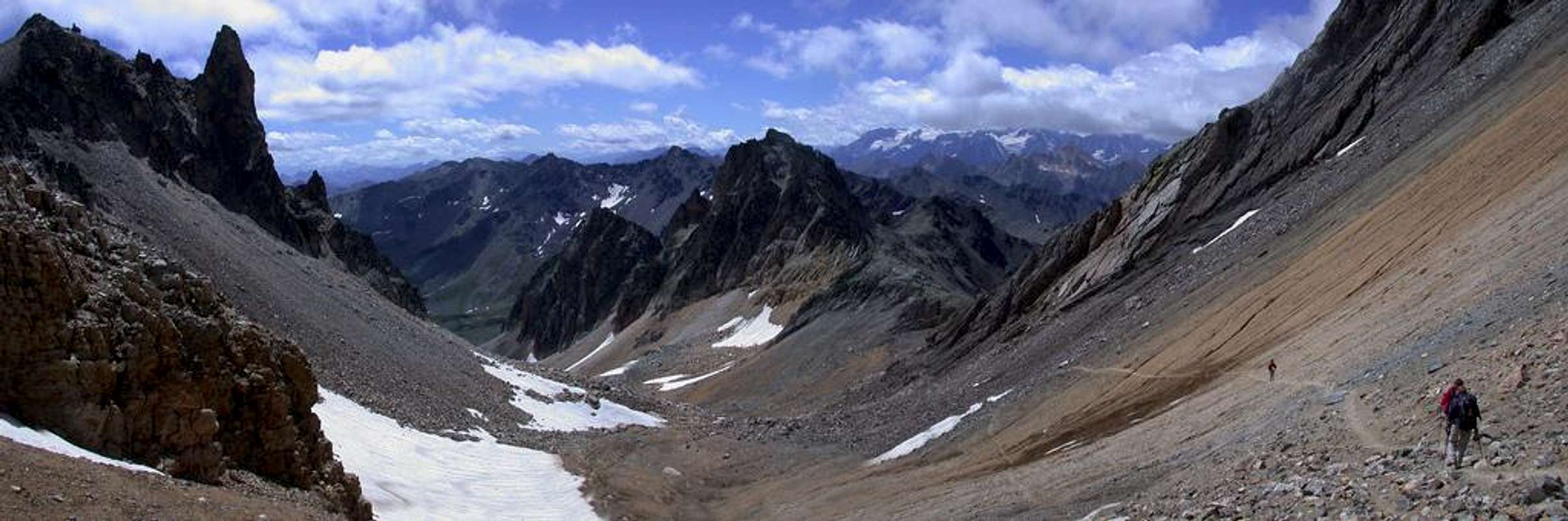
After the mine, with a short climb get to 2,200 meters s.l.m. at the bridge of Planche, after passing the stream climb along the stream named Desinare on its orographic right side. You gain the large Planche plateau (or Serous). Cross the stream on a bridge, head towards the North East for bumps and grassy slopes. After passing under the Serous wall, the path bends to the left, getting the Col des Meandes 2727 m. From the col, beyond some big cairns, head to the left and start the last steep climb, The pastures leave room for a band of rocks and debris and the environment becomes lunar with the characteristic reddish terrain. Pass a stretch equipped with two metal bridges over a landslide area, reaching some crosses placed on a panoramic shoulder (elevation 2832). Reached the shoulder, the route gains definitely altitude along the detrital summit slopes, often snowy at the beginning of the season, and heads in the direction of the Chapel of Monte Thabor, now clearly visible, located near the summit, from which briefly to the summit at 3178 meters

|

|
There are numerous paths that lead you to the base of the mountain. Be sure to pass along the Lac du Peyron (2450 m), a beautiful, yet ice cold lake. From there you have to get by a multitude of massive rock and debris which dominate the small lake. The map leaves you somewhat confused at this point. But no worries: after half an hour you'll find yourself again on walkable terrain again.
Italian Version
Si può raggiungere la vetta partendo dalla Valle Stretta e passando accanto al Rifugio Terzo Alpini, vicino al quale si parcheggia. Continuare a camminare sulla strada sterrata fino al Ponte della Fonderia 1911 m, poi attraverso un bosco rado si raggiungono le vecchie miniere di ferro del Banchet. Dopo la miniera, con una breve salita si arriva a 2200 metri s.l.m. al ponte di Planche; dopo aver superato il torrente, si sale lungo il rio chiamato Desinare lungo il suo lato orografico destro. Si raggiunge così il grande plateau Planche (o Serous). Attraversare il torrente su un ponte e dirigersi verso nord-est per dossi e pendii erbosi. Dopo essere passato sotto le pareti del Serous il sentiero si piega a sinistra, raggiungendo il Col des Meandes 2727 m. Dal colle, oltre alcuni grossi ometti, dirigersi a sinistra per iniziare l'ultima ripida salita. I pascoli lasciano spazio a una fascia di rocce e detriti e l'ambiente diventa lunare con il caratteristico terreno rossastro. Passare un tratto dotato di due ponti di metallo su una zona di frana, raggiungendo alcune croci posizionate su una spalla panoramica (elevazione 2832). Raggiunta la spalla, il percorso guadagna decisamente quota lungo i detritici pendii sommitali, spesso nevosi all'inizio della stagione, dirigendosi verso la Cappella del Monte Thabor, ora ben visibile, situata vicino alla cima, da cui brevemente si raggiunge la vetta a 3178 metri.
Ci sono numerosi percorsi che conducono alla base della montagna. Assicurati di passare lungo il Lac du Peyron (2450 m), un lago bellissimo, ma ghiacciato. Da lì occorre superare una moltitudine di massi e detriti che dominano il laghetto. La mappa lascia un po 'confusi a questo punto. Ma non preoccuparti: dopo mezz'ora ti ritroverai di nuovo su un terreno percorribile.
Red Tape
No fees no permits required. Parking in Valle Stretta costs 2 euros.
Hiking grades of difficulty
T - Turistico (Tourist): Itineraries on wide, clear and well worn paths, sometimes on mule tracks or gravel roads. The routes are never exposed, don't give any orientation problems and don't exceed 2500 meters of altitude. Suitable also for children
E - Escursionisti (Hikers): Itineraries on marked trails, even narrow and with possible steep and impervious sections. They are never exposed and don't give any orientation problems. They can tread different kinds of ground, such as forests, gravel, meadows, pastures, easy rocks, etc.). They form the majority of the trails that wind up in the mountains and require a certain habit to walk; you need equipment suitable for the altitude and resistant footwear with soles suitable for rough terrain
EE - Escursionisti Esperti (Experienced Hikers): Itineraries for hikers with experience and good knowledge of the mountain. Some of these paths may have exposed sections, however brief, which require firm foot and no dizziness. They require the ability to adapt to particular terrain, such as steep grassy slopes or stretches of rocks with difficulties that can reach the 1st degree of the UIAA scale. They can also reach high altitudes (3000 m or more). Sometimes they may include unmarked sections, requiring a good sense of orientation. Snow slopes are possible, however which can be overcome without specific mountaineering gear (rope, harness, crampons, ice-axe)
EEA - Escursionisti Esperti con Attrezzatura (Experienced Hikers with equipment - The same as EE, in addition these routes require the use of via ferrata equipment (lanyards, harness, carabiners, heat sink, helmet). This kind of itineraries range from the trails with short easy and not much exposed sections, previously equipped with fixed ropes and iron pegs, to the true and more difficult Via Ferratas climbing on rocky walls or on aerial ridges and ledges, previously equipped with long stretches of iron ropes, iron steps, ladders without which proceeding would constitute a real climbing. It is necessary to know how to use the technical equipment and have a certain habit of exposure and mountaineering terrains.
Accomodation

Both these shelters are located in Valle Stretta, Grange di Valle, where the road ends.
Guarded from 21 june until 7 september. Reservations can be made by calling 0479203213, or 0479052796.This hut is accessible is a point of support for the ascent starting from the Valle dell'Arc or for the crossings starting from the previous shelters in the Valle Stretta through the Colle di Valle Stretta.
Finding a spot for your tent shouldn't be a problem near one of the refuges
.
When to climb
The best period goes from June to September
Meteo
- Meteo ARPA Piemonte - Meteo France
Guidebooks and maps

Bardonecchia - Monte Thabor - Sauze d'Oulx IGC n. 104
External Links