
|
|
Mountain/Rock |
|---|---|
|
|
46.37640°N / 7.46208°E |
|
|
Scrambling |
|
|
Summer |
|
|
9678 ft / 2950 m |
|
|
The Rohrbachstein
is a peak that has the appearance of a rock “hub” on a scree ridge on the south-west edge of the moon-like moraine circle surrounding the glaicial lake-like plain of the Glacier de la Plaine Morte. It is technically easy to get up; there is only one passage before reaching the top that is marked “II” in the alpine guide-book; otherwise it is a walk along an alpine trail to the foot of the “hub” and then a short scramble from the south west to it’s summit. Views are magnificent to all sides – the western Bernese, Fribourg and Vaudois Alps to the west and the north west, the bulk of the Wildstrubel, the Glacier de la Plaine Morte and the moon-like moraine landscape surrounding it to the east; to the south the entire chain of the Pennine Alps from Monte Leone to Grand Combin, with all of the 4000ers being visible, and to the south west, the Mont Blanc range. Best period to go up it is normally between end of July and beginning of October. The Rohrbachstein seen from the north
 The hub-like summit rock of the Rohrbachstein
There are two possible bases for the ascent of this mountain; Iffigenalp above Lenk im Simmental in the north and Crans-Montana in the south. From Crans-Montana it is advisable to take the cable-car either to Bella Lui or to the middle station of the Pointe de la Plaine Morte telepherique, which brings you to the Cabane des Violettes.
More information in the chapter “Routes”.
Getting There
Getting to Iffigenalp above Lenk im Simmental:Nearest airports: Zürich, Basel, Geneva
Coming by car from Zürich: Follow the motorway N1 to Bern, then the N6 to Spiez. Exit at Spiez and follow the road to Zweisimmen. At the roundabout in the center of Zweisimmen, turn left and head for Lenk, which is reached after another 13 km. In Lenk, turn right and follow the road 8 km up to Iffigenalp (the road is slightly rough here and there). Distance Zürich-Iffigenalp: 210,7 km, duration: 2h 40 min.
Coming by car from Basel: Take the motorway N2 in the direction of Bern/Zürich/Luzern; at crossroads switch to the N1 in the direction of Bern, then continue as indicated above. Distance Basel-Iffigenalp: 183,2 km, duration: 2h 23 min.
Coming by car from Geneva: Follow the motorway N1 as far as above Lausanne, then switch to the N12 direction Fribourg-Bern and follow it until Bulle, exit the motorway here and follow the signs to Jaunpass-Boltigen. In Boltigen, turn right and pass on to Zweisimmen. From here, continue as indicated at the top. Distance Geneva-Iffigenalp: 181,1 km, duration: 2h 34 min.
Coming by means of public transportation: From Zürich: Take the fast direct train bound towards Interlaken or Visp-Brig as far as Spiez, change here to the regional train to Zweisimmen, then change to the MOB train to Lenk. In Lenk, use one of the post-busses that commute regularly between Lenk and Iffigenalp. From Basel: Take the fast train bound for Interlaken or Visp-Brig, alight in Zweisimmen and continue as indicated above. From Geneva: Take the fast train bound for Sion-Brig-Milano as far as Montreux. Here, change to the MOB train to Zweisimmen (a fairly slow but very enjoyable trip through the Pays d'Enhaut!) and in Zweisimmen, change to the MOB local train to Lenk. From here, take the post-bus up to Iffigenalp.
Getting to Crans-Montana:
Nearest airport: Geneva
Coming by car: From Geneva, take the motorway A1 as far as Lausanne, then the motorway A9 via Martigny and Sion to exit 28 Sierre-ouest. Follow signs from here to Crans-Montana. Distance: 187.9 km, duration: 1h 59min.
Coming by public transportation: From Geneva Airport or Geneva Gare de Cornavin (the main train station in Geneva), take one of the fast trains bound for Brig or Milano (there is one at least every hour heading for Brig) and alight in Sierre. From here there are postal cars to Crans-Montana.
Red Tape
Be sure that the weather is stable before undertaking this hike. Especially between Weisshornlücke and Rohrbachstein, when you are moving in the moraine high-plateau-like landscape surrounding the Glacier de la Plaine Morte, it is easy to get lost when there is fog.Routes of ascent
Route 1: coming from Iffigenalp (1584m) on the north sideHeight difference between base and top: 1366 meters (4482 feet)
Duration: about 5 hours 45 minutes
Character: marked alpine trail as far as Weisshornlücke, unmarked trail leading up the crest and around the rock hub of the summit to it’s southwest base, then a short scramble, with one short passage being “II”, secured by a rope.
The one snag – to bring in a “moment of truth” – about the ascent I’m about to describe is that the cable-car Iffigenalp-Weisshorn (not for public use; only for the military and people working for Skyguide; the summit of the Weisshorn (2947m) is used as a surveying point for civilian and military aeronautics supervision. Therefore the actual summit of the Weisshorn with all of it’s installations on top is forbidden and closed in by a fence) follows almost precisely the same line as far as the Wildstrubel hut on 2793m. From time to time items are left behind, which can present rather bemusing scenes to the hiker:

 Lower Rawilseeleni lake
 pt. 2884.8 and Rohrbachstein seen from the Weisshornlücke
Route 2: coming from Crans-Montana (1500m) on the south side
As the areas above Crans-Montana are quite overridden with skilifts and the like, which makes the walk from Crans-Montana to Bella Lui (2543m) or Cabane des Violettes (2204m) not over-attractive, it is advisable to make use of the cable-cars leading to these points. I will therefore start my route description from here, rather than from Crans-Montana itself.
Height difference: Cabane des Violettes-Rohrbachstein: 746 meters (2447 feet)
Bella Lui-Rohrbachstein: 450 meters (1476 feet)
Duration: From the Cabane des Violettes: 4,5 hours, from the Bella Lui ca. 3,5 hours
Character: marked and unmarked trails through alpine grass and scree.
From Cabane des Violettes or from Bella Lui, follow the trail to Col de Pochet on 2500 meters (When coming from Bella Lui, there is a short ladder passage to be tackled just before reaching the Col de Pochet). Follow the trail in north western direction, heading straight for the Rohrbachstein, first moderately steep and then quite steep through scree until the col west of pt. 2884.8. From here, continue as indicated in Route 1.
 Great views to the Pennine Alps
 Upper Rawilseeleni lake and Wildhorn
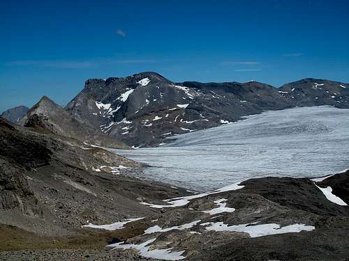 View upon Glacier de la Plaine Morte and Wildstrubel
Alpine huts
Cabane des Violettes, 2204m (link in German)Wildstrubel hut, 2793m
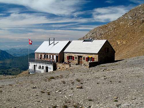 The Wildstrubel hut
Gear
No additional gear needed, though good wind and weather protection is strongly recommended.Maps
Use the following maps of swisstopo: 1266 Lenk, 1267 Gemmi, 1287 Sierre. All three are scaled 1:25000.Then there is also the swisstopo-map 263 Wildstrubel in 1:50000.