
|
|
Mountain/Rock |
|---|---|
|
|
48.94570°N / 117.15°W |
|
|
7320 ft / 2231 m |
|
|
Overview
This is the highest peak in Washington.........outside of The Cascades and the The Olympics. That is, it is the highest point of land in Washington east of the Sinlahekin Valley (i.e., east of the Okanogan River). By Cascades and Olympics standards, it's not a real compelling objective. But if you're a peakbagger or someone interested in attaining the highest point in each Washington county (Gypsy Peak is the highest point in Pend Oreille County), then it may be worth the effort. For sure, it offers a perspective of what a 7,000+ ft peak looks like in the northeast corner of the state. For me, its mostly open upper reaches reminded me of something in England's Lake District (though obviously twice as high as most everything in the Emerald Isle).
The mountain is characterized by forested footings and rocky though vegetated shoulders. The summit area is quite rocky and the northern basins of it and surrounding peaks do contain significant cliffs. I looked through the summitpost database and noticed no Washington summits outside of the Cascades or Olympics were represented, so I just had to make a page for Gypsy Peak. I felt I had enough photos from my trip there in July 2003 to give Gypsy Peak its 15 minutes of fame.
A note about the height: the peak has supposedly been triangulated at 7,309 ft, which is just one foot higher than nearby Abercrombie Mountain (which is 13 miles to the west in the Selkirk Mountains). However, the triangulation post is not at the summit but below it by about twelve feet. Whether the surveyors took this into account in gauging the elevation, I don't know. Also, if you look on a USGS map, there is a 7,320+ ft closed contour at the summit, meaning the peak must be at least that high. Either way, it's about 7,320 feet above mean sea level at the top of your head when you're standing up. If it happens to be low tide on the Washington coast, maybe you're as high as 7,330 ft. Woohoo!
 |  |  |  |  |
Getting There
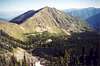
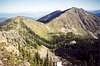
Gypsy Peak is located in the extreme northeast corner of the state in the horseshoe-shaped Salmo-Priest Wilderness. The wilderness is so-named due to the bounding Salmo Creek on the north and Priest River (which is in Idaho) on the east. One could probably manage to climb Gypsy from any direction, but the quickest way (and the way I went) is from the end of FR-200. The end of FR-200 is about 2 miles due south of the summit. The end of this road coincides with the Sullivan Mountain Trailhead. Sullivan Mountain (6,483 ft) is a lesser mountain with a lookout at its top located 7 miles southwest of Gypsy Peak at the west end of Crowell Ridge, of which Gypsy Peak and Gypsy Ridge are connected. In fact, there is a road that goes to the top of Sullivan Mountain, but it starts nowhere near the Sullivan Mountain Trailhead.
From the trailhead at 5,550 ft, the idea is to take the Sullivan Mountain Trail for about a mile to where it makes a sharp switchback in a depression. The trail continues on around the south side of Crowell Ridge and thereby leads away from Gypsy Peak. Leave the trail at the switchback and head generally northwestward or northward into the upper Leola Creek basin then eventually into the ridge ahead of you. Once on the ridge, follow it northward over Pt. 6853 then up to Pk 7177. You won't get your first view of Gypsy Peak until you get to the top of Pk 7177. The north side of Pk 7177 is cliffy. Down below is Watch Lake at the head of Watch Creek. From the top of Pk 7177 you'll see what you need to do: drop down to the northwest and continue along the ridge (over one hump [Pt. 7033]) to Gypsy Peak. The entire climb is non-technical and trivial. It took me about two hours from the car with rest and photo breaks. Return the same way.
To get to the trailhead, the easiest way is to take Sullivan Lake Road from Metaline Falls. At the lake, continue east on FR-22 in the valley bottom or FR-2212 on the southeast slope of Crowell Ridge--the latter goes past the junction for the road up to Sullivan Mountain. If taking FR-22, go about 4 miles to the junction with FR-2200 (FR-22 turns right). Continue on FR-2200 for about six miles to the east-end junction with FR-2212, taking it up the hill a couple of miles to the FR-200 junction. Take FR-200 northeastward. Note: there was an open gate with a sign that said the road will be closed from August 15 to November 30 or some time thereabouts. This is probably for wildlife considerations. Continue on FR-200 (gets bumpy and slightly overgrown in places) to its end at the trailhead.
Another shorter eastern approach to FR-22 is by way of Hwy 57 from Priest Lake in Idaho. Hwy 57 turns into FR-302, which eventually gets to Pass Creek Pass (Shedroof Divide) and turns into FR-22 (as above). Descend to the valley bottom to the aforementioned junction with FR-2200 and go right. Continue approach as above.
Yet another way to get to Gypsy Peak would be via Slate Creek Road (FR-3155) west of Gypsy Ridge. Having not been up that road, I'm not sure if it is accessible to the public. Certainly, the terrain is open forest and sub-alpine on the west side of the peak.
 |  |  |  |  |
Red Tape
Gypsy Peak is in the Salmo-Priest Wilderness, so standard Wilderness policy applies (no motorbikes, etc.). Other than that, I don't recall seeing any Trail Park Pass signs or registration boxes. I suppose the area is so uncommonly visited that such permitations would be a waste of resources.
When To Climb
Gypsy Peak could be climbed at any time of year provided you can get to it. The treeless upper slopes could be avalanche-prone in winter and spring. In summer you can expect snowpatches and running water. Plus, Watch Lake would provide a filterable source. It's a short enough roundtrip that bringing all your own water from the car should not be too much of a hassle. The total elevation gain from car to summit is about 3,000 feet including all the ups and downs along the ridge.
Camping
I guess you could camp anywhere you like, if you were so inclined. The upper Watch Creek Basin would be suitable, as would any flat saddle.
External Links
- Vanishing Habitat in the Selkirk Mountains
Cougars and humanity are taking their toll on the caribou population in the Selkirk Mountains, of which Gypsy Peak is a part.
Klenke - Jul 5, 2005 2:16 am - Hasn't voted
Untitled CommentThanks for stopping by. The peak does offer a gypsy's view of the world.
I was already aware of the elevation quandary. In fact, read the third paragraph of the overview.
supreme744 - Jul 5, 2005 1:25 am - Hasn't voted
Untitled CommentAlthogh Gypsy is listed 1 foot higher than nearby Abercrombie Peak at 7309 ft., We determined Gypsy is 12 to 15 feet higher than reported at the actual summit. Best guess 7320+. This hike had some incredible open views along the entire route with spectacular views of the international borderp with Canada and the Canadian Selkirks.
Klenke - Jul 5, 2005 2:16 am - Hasn't voted
Untitled CommentThanks for stopping by. The peak does offer a gypsy's view of the world.
I was already aware of the elevation quandary. In fact, read the third paragraph of the overview.
Brian Jenkins - Jun 24, 2023 7:49 pm - Voted 10/10
road blockedFR 2212 is blocked by a large boulder now about a half mile from the turn off. Can't get close to Bear Pasture TH now as far as I can tell. It is supposed to come back down farther on 2220 but from what I can tell that road is grown in with trees now. Think the only feasible way now is via Sullivan Mtn/Crowell Ridge which means like a 26-28 mi RT now. Hopefully the boulder is moved soon but I'd call the rangers.
aepler315 - Aug 8, 2023 2:49 am - Hasn't voted
Re: road blockedTake Highline road off Sullivan Lake road. It's about 1/4 mile north of Sullivan Creek road