The page was successfully edited.

-
 6467 Hits
-
 81.18% Score
-
 13 Votes
|
|
Mountain/Rock |
|---|---|
|
|
37.87699°N / 107.83125°W |
|
|
Download GPX » View Route on Map |
|
|
San Miguel |
|
|
Hiking, Mountaineering, Scrambling |
|
|
Spring, Summer, Fall, Winter |
|
|
13470 ft / 4106 m |
|
|
Overview
 Silver Mountain B
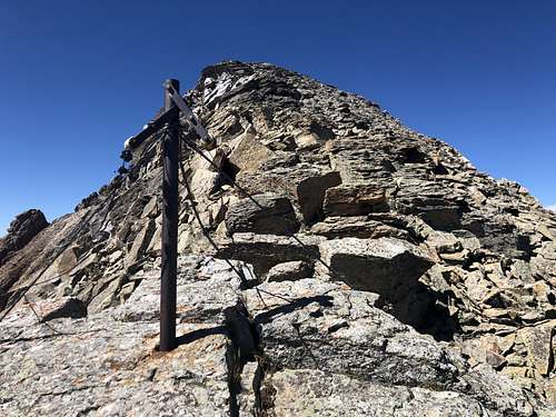 Silver Mountain B
B - because there is Silver Mountain A (bicentennial peak) located also within San Juan Mountain Range. There are many mountains named Silver in Colorado due to the abundance of mining. This one is the 2nd highest Silver Mnt. in Colorado.
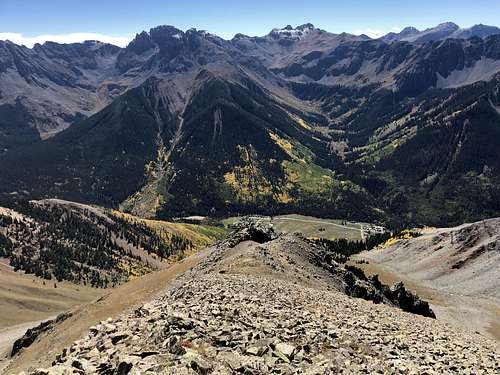
![Nice autumn colors]() Nice autumn colors as seen from the slopes of Silver Mountain
Nice autumn colors as seen from the slopes of Silver Mountain![Silver Mountain to San Joaquin]() Silver Mountain to San Joaquin
Silver Mountain to San Joaquin
![South slopes/ridge up Silver Mountain]() South slopes/ridge up Silver MountainSummer and early autumn are obviously the easiest months. The autumn with aspens changing colors is especially spectacular!
South slopes/ridge up Silver MountainSummer and early autumn are obviously the easiest months. The autumn with aspens changing colors is especially spectacular!
The hike/scramble is pretty straightforward and one can see the summit from the little settlement of Ophir. Expect immediate steep walk. I was able to found a trail, which I lost higher up. The views are spectacular and the ridge offered more scrambling than I expected. Not too technical if one knows the route! Expect going over many false summits.
Colorado Rank: 274
Class: 2+
Parent Lineage: proximate parent: Wasatch Mountain; line parent: Lookout Peak
Saddle between Silver Mountain A and San Joagin Ridge is 13,060 feet.
Uncompahgre National Forest - Silver Mountain is located within.
Nearby Peaks:
- Palmyra Peak 0.47 miles
- San Joaquin Ridge 0.98 miles
- "Oscars Peak" 2.05 miles
- Wasatch Mountain 2.13 miles
- "T 12" 2.72 miles
- La Junta Peak 2.77 miles
- Lookout Peak 2.97 miles
Getting There
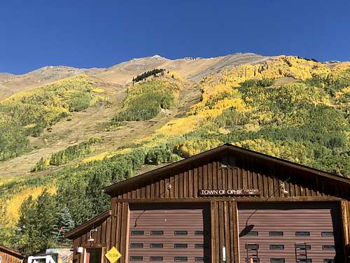
From Telluride drive south on Highway 145 past the turn off for Mountain Village until you hit the turn off for Ophir. Drive east to the town past the Ophir Wall (good rock climbing) to the small community of Ophir. The road is a good dirt road leading to Ophir Pass. I chose to park in the town of Ophir between the two parts of housing. There was a pull put on the road. Ophir gets often avalanches, so people build home in clusters away from avalanche pathways.2 WD low clearance vehicle is fine on this outing, but NOT if you choose to drive up the Ophir Pass Road and cut towards Million Dollar Highway.
Route
As any mountain there are many different ways to reach its summit. I will describe my hike as a loop starting from Ophir, ascending south slopes of Silver Mountain, traversing onto San Joaquin Ridge and finally along the ridge all the way to Oscars Peak. This loop can be also done in an opposite direction. Silver Mountain also has north facing couloir, which can be climbed/skied if conditions suitable and not a high avalanche risk.I started to use Gaia application, pretty useful and easy to use. I was moving slowly, enjoying the fall views and took is as a relaxing day away from work.
The start point is Ophir. I went up south facing slopes of Silver Mountain and was able to intercept a small trail, which was not very apparent at places, but always somehow ended back on it. There was no trail for the past section to reach the ridge, but the route finding was obvious here. The summit was decorated with a cairn and summit register. The views spectacular.
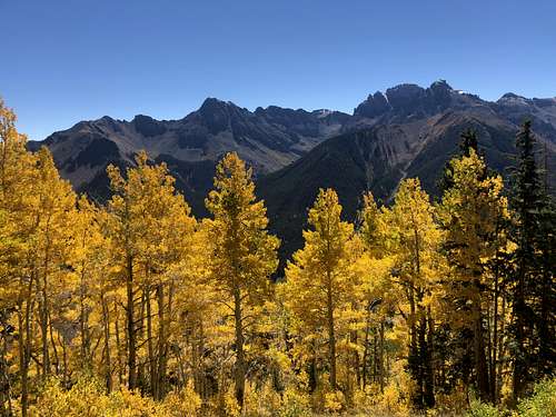 Nice autumn colors as seen from the slopes of Silver Mountain
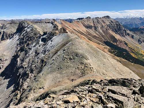 Silver Mountain to San Joaquin
The ridge to San Joaquin was interesting at least to say. I did not expect to go over so many summits. At one of those false summits I had a little zigzagging exercise as seen on the map when enlarged. The summit did not go - there was 50 foot steep cliff, but when I backtracked I found a south facing gully taking me below those cliffs and bypassing this obstacle. The rest of the ridge to San Joaquin was pretty uneventful. I read reports about people going down towards Carbonero Mine cca halfway between Silver and San Joaquin, and then getting onto a dirt road.
The ridge from San Joaquin to Oscars got easier and went on quickly. Just below the Oscars peak on its east side is Oscars pass and a nice trail, which leads all the way to the Ophir Pass Road. This section of the trail is part of the 100 mile endurance Hardrock Run.
Red Tape
Hiking, climbing and parking your vehicle is free. Do not expect much services in Ophir. I don't think there is even a convenience store. Nearby Telluride is worth while a visit.When to Climb
 South slopes/ridge up Silver Mountain
Spring can provide an interesting outing if snow is stable. There is a north facing couloir if one is coming from Telluride side.
I would like to mention that Ophir area is infamous for avalanches and if you have time you can you tube some scary looking avalanches recorded from people's homes.
When you drive through the little settlement of Ophir, check out the distribution of houses - structures are close together in safe areas and town appears to be separated by a huge avalanche path (see the photo on the left).
Always check northern San Juan avalanche conditions prior venturing out during the snow season!
Camping
There are no designated Forest Service campgrounds near Ophir and along the FR630 = Ophir Pass Road. There are a few primitive sites where you can camp overnight, make sure you are not on a private land. I think there would be ok camping at the trailhead going up to Oscar's Pass, but you would need a 4 WD vehicle to drive a short section of this 4 WD road, which shortly changes into a trail (this trail is a section of famous Hardrock 100 mile endurance run).There is a developed Sunshine campground along the Highway 145 - no reservations, first come first serve basis. Only 15 sites.
Matterhorn campground is larger and there are showers available there. It is also located along Highway 145, little bit further south.