Overview

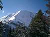
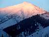
Some locals around Sun Valley know this peak as Otto's Peak, Rock Roll Peak, or simply the big one out Lake Creek. Whichever you choose, this mountain is a great conditioner for higher, more rugged peaks in the Boulder Range and, to top it off, the views from the summit are spectacular.
Rock Roll Peak takes on a different shape in every direction from which it is viewed. Located just northwest of Ketchum, this is the southernmost major summit on the main Boulder Crest. When viewed from the north and west, Rock Roll peak appears as a benign and less than worthy summit to pursue. However, when viewed from the north and east (along Trail Creek Pass), its impressive face forms jaw-dropping vistas. Rock Roll Peak is most commonly climbed from Lake Creek, though it is possible, (and more difficult), to climb from Park Creek. One of the many great features about this mountain is that not only does it offer incredible views, all routes are class 2 allowing the beginner hiker to explore this territory.
Getting There
Access from Lake Creek sees the most traffic for climbing Rock Roll. Just drive north of Ketchum about 4 miles and turn right on the Lake Creek Road. Drive past the beautiful homes, onto the dirt road and in about 4 miles the road will come to the large basin beneath Rock Roll Peak. Look for the old mining road (marked with a sign off to your right), called High Ridge Road. Follow this until you reach a point just below the saddle between Rock Roll's south ridge and Pt. 9,557. Leave the trail and gain to the saddle. Follow the south ridge to the summit. To reach Rock Roll from Trail Creek, head northwest of Sun Valley on Trail Creek Road. Go a little bit past the summit and take Park Creek Road on your left. Follow this for about 2 miles until you see a sign reading High Ridge Trail on your left. Park at the trailhead and follow this trail for about 3 miles until just below one of Rock Roll's many ridges. Some of these ridges require technical climbing so i recommend remaining on the trail until reaching the south ridge. Follow it to the summit.
Red Tape
No permits or red tape required. Both Trail Creek and Lake Creek Roads close in winter.
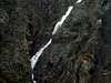
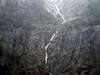
Area Views
Sorry for not having summit views. it was too foggy but here are some views of the surrouding areas.
When To Climb
Rock Rolll is usually climbed in the summer months, though hardy back country skiiers have been known to have winter ascents... Watch out though, Rock Roll's south east canyon (Rock Roll Canyon), its famous for its explosive avalanches during winter.
Camping
Being so close to Ketchum, hotel oppotunities are abundant. But if wishing to camp, there is ample space in the basin below Rock Roll Peak on the Lake Creek side and Park Creek CG is but just a few miles from the High Ridge Trail.
Mountain Conditions
The land around Rock Roll Peak is managed by the Sawtooth National Forest. Their number is (208) 727-3200. Rock Roll Peak expresses tremendous exposure, take usual precedures to prepare for back country conditions.