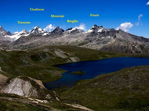
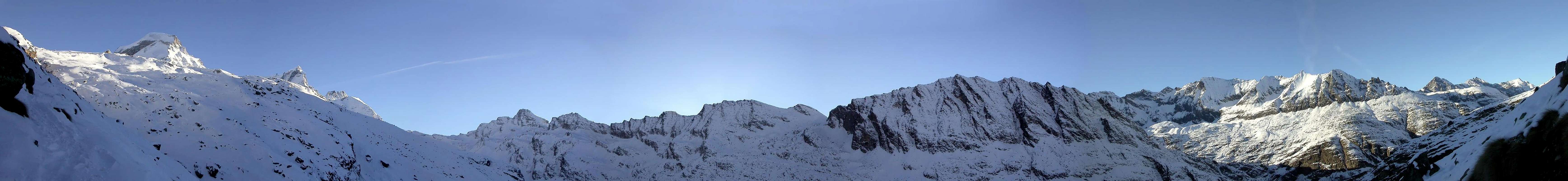
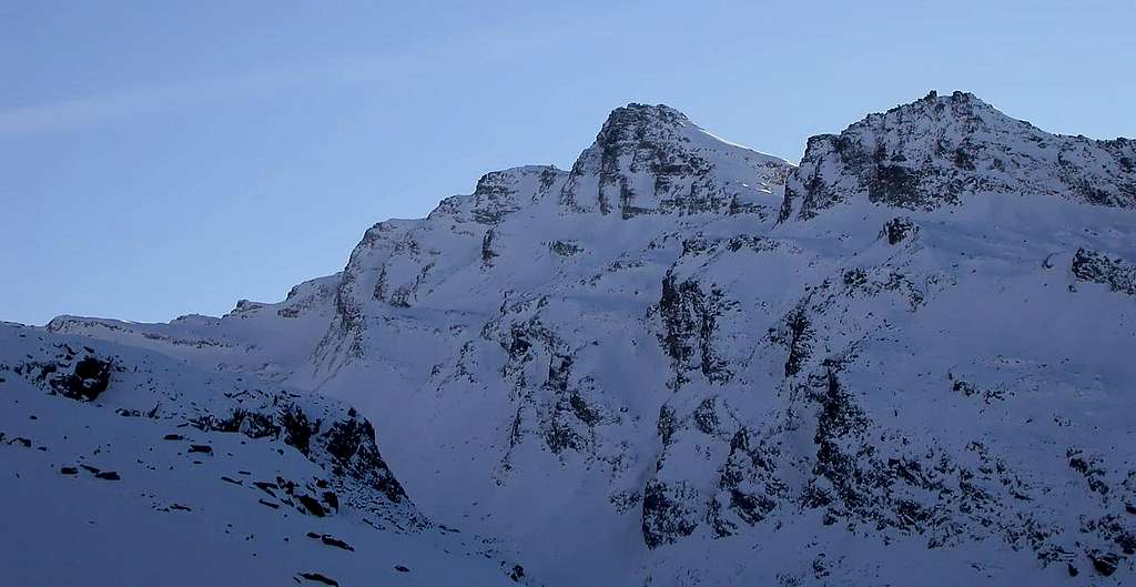
It's the highest Summit of the ridge dividing the high part of Valsavarenche from the Nivolé Plain, (the widest highland of Val d'Aosta more than 6 km long). From the summit very fine views on the SW Side of Gran Paradiso and the summits of the close Valle di Rhêmes. In practice, starting from the Western Col of the Grand E'tret (3.172m) and crossing the Punta Mare Percia (3.385m), from Punta Fourà it extends towards N-NW that buttress which, with the Cime di Seiva or Seyvaz (Meridional 3.207 meters, Septentrional 3.074 meters), Monte Giansana (3.051m), reaches the Cima dell ' Arolley or even Pointe de la Roley (2.995m) separating the Vallone della Seiva (to the East) from the Pianoro (Tableland) del Nivolé or Nivolet. Beyond the buttress, dividing the Valsavaranche from the Rhêmes Valley, it rises with the very long watershed that comes from the distant Punta Galisia (3.446m) and which descends flexing N-NE until it reaches the Dora Baltea on the axis of the Central Valley. This mountain, therefore arranged along the S-SE/N-NW axis, is formed by two wide slopes that stretch above the Glacier Oriental de Pointe Fourà to the Northeast and completely to the Glacier du Grand E'tret to the East, while on the the opposite or Western side its rocky walls overlooks Colle Ferauda (3.033m), at the Southeastern end of Pian del Nivolé. Moving on to the morphology of the mountain, it must be observed in detail that it has more facets than it seems.
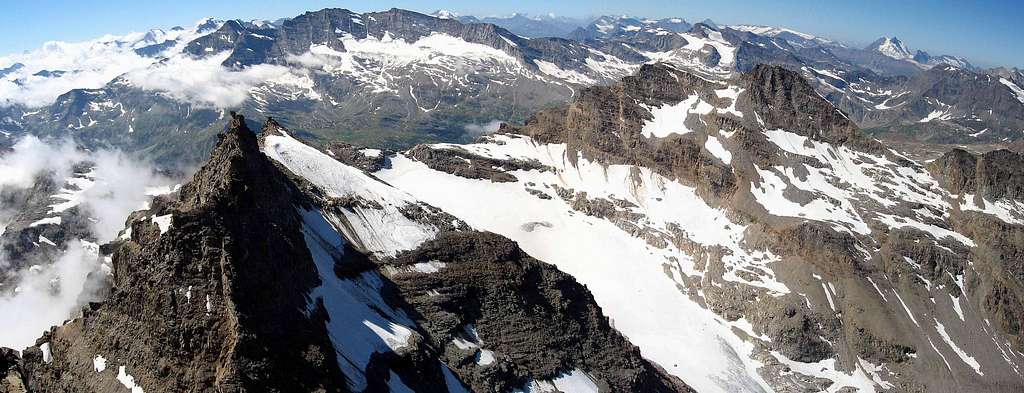
a) - The Northern side, where the Via Normale rises NW Crest annecting with Northern Slope), is formed by an insignificant detrital-rocky slope which is contained
b) - to the right (West) by the NW Ridge which originates from the Northwestern Ante summit and to the left (East) from a small rocky rib
c) - which, in turn, together with the SE Crest contains the East Face
d) - The latter can be divided into four sectors:
1) - the Northernmost sector which forms a kind of triangular wall more adressed to the NE (Via Santurini of august 1938), that falls above the Eastern Glacier of Punta Fourà;
2) - a rocky rib facing E-NE which practically divides the NE Face from the one definitely facing East; this is the highest crest in altitude of the entire slope together with the one parallel at the left end (South, beyond which, but therefore with greater precision further to the E-SE, the route of the first climbers of 1867 climbs) and ends on the Ante Summit NW (via August 1990);
3) - a sharp and steep rocky edge with the first third in crushed rock but which ends , at the top, becomes very steep and ends at the Summit (Direct Route by lone of Cardellina on July 1980);
4 - a Southern sector (first mountaineers route or by the renowned Martino Baretti with Aldo Blanchetti on summer 1867 and with first winter ascent in December 01th, 1940) formed by more broken rock and which runs out against the
e) - short but "nice" SE Ridge, which comes from Mare Percia (3.385m). Ridge which is a beautiful climb on steep but healthy rock and full of holds (route of 26 June 1927 downhill and of July 1929 uphill). Finally
f) -, starting from this last peak as well as unfolding towards the North, stands the beautiful SW Wall which, in turn, can be divided into three sections:
5) - an elegant and slender sector up to the Summit in the extreme South with a beautiful route (from III° to IV°), traced in the summer of 1960, repeated in July 1963 and with the first winter ascent in January 05th, 1975;
6) - a central sector, below the North Ante Summit and the Northwest Shoulder, still untouched;
7) - while its Northern Edge has a face more facing S-SW, as well as a "stump", that breaks on the NW Crest and where a "mixed" route has been traced (SO Wall plus NO Ridge) in July 1954, in solo by Nino Daga Demaria. As we can see, something still remains to be done: at least on the Western front ...
E' la vetta più elevata della catena divisoria dell'Alta Valsavarenche dal Pian del Nivolé, il più lungo della Valle d'Aosta con oltre 6 Km. di lunghezza. Ottimo panorama sul Versante Sud-Ovest del Gran Paradiso e sulle vette della vicina Valle di Rhêmes.
In pratica, partendo dal Colle Occidentale del Grand E'tret (3.172 m) e scavalcando la Punta Mare Percia (3.385 m), dalla Punta Fourà si dispiega verso N-NO quel contrafforte che, con le Cime di Seiva o Seyvaz (Meridional 3.207 metri, Septentrional 3.074 metri), il Monte Giansana (3.051 m), raggiunge la Cima dell'Arolley oppure Pointe de la Roley (2.995 m) separando il Vallone della Seiva (ad Oriente) dal Pianoro del Nivolé o Nivolet. Oltre il contrafforte, divisorio la Valsavaranche dalla Valle di Rhêmes, si rialza con il lunghissimo spartiacque proveniente dalla lontana Punta Galisia (3.446 m) e che scende flettendo a N-NE fino a raggiungere la Dora Baltea sull'asse della Valle Centrale. Questa montagna, disposta dunque lungo l'asse S-SE/N-NO, é formata da due ampli versanti che si allungano al di sopra del Glacier Oriental de Pointe Fourà a Nordest e sul Glacier du Grand E'tret ad Oriente, mentre sul lato opposto od Occidentale le sue pareti rocciose sovrastano il Colle Ferauda (3.033 m), al termine Sudorientale del Pian del Nivolé. Passando alla morfologia della montagna c'é da osservare in dettaglio come la medesima presenti più sfaccettature di quanto non sembri.
a) - Il Versante Settentrionale, dove sale la Via Normale (Cresta NO e Versante Nord), é formato da un insignificante pendio detritico-roccioso che viene contenuto
b) - a destra (Ovest) dalla Cresta NO originantesi dall'Antecima Nordovest ed a sinistra (Est) da una piccola costola rocciosa
c) - che, a sua volta, insieme alla Cresta SE contiene la Parete Est
d) -. Quest'ultima può essere suddivisa in quattro settori:
1) - il settore più Settentrionale formante una specie di parete triangolare rivolta a NE (Via Santurini dell'agosto 1938), che cade sopra il Ghiacciaio Orientale di Punta Fourà;
2) - una costola rocciosa rivolta ad E-NE che in pratica divide la Parete NE da quella decisamente rivolta ad Oriente; é questo il crestone più alto in dislivello insieme alla parallela costola all'estrema sinistra (Sud, oltre la quale, ma quindi più ad E-SE, sale la via dei primi salitori del 1867) dell'intero versante e si conclude sull'Antecima NO (via dell'agosto 1990);
3) - un netto e ripido spigolo roccioso che nel primo terzo é formato da roccia frantumata ma che, in alto, diventa ripidissimo e conclude sul Vertice (Via Diretta in solitaria Cardellina del luglio 1980);
4) - un settore Meridionale (via dei primi salitori cioé il celebre Martino Baretti insieme ad Aldo Blanchetti nell'estate del 1867 con prima invernale assoluta il 01 Dicembre 1940) formato da roccia più rotta e che si esaurisce contro la
e) - breve ma "simpatica" Cresta SE, proveniente dalla Mare Percia (3.385 m). Cresta che costituisce una bella arrampicata su roccia ripida ma sana e ricca di appigli (via del 26 giugno 1927 in discesa e del luglio 1929 in salita). Infine
f) -, proprio partendo da questa ultima vetta nonché dispiegandosi verso Settentrione, si staglia la bella Parete SO che, a sua volta, può essere suddivisa in tre sezioni:
5) - un settore elegante e slanciato fino alla Sommità all'estremo Meridione con una bella via (dal III° al IV°) tracciata nell'estate del 1960, ripetuta nel luglio 1963 e con prima salita invernale nel gennaio del 1975;
6) - un settore centrale, sottostante l'Antecima e la Spalla NO, ancora inviolato;
7) - mentre il margine Settentrionale presenta una faccia più rivolta a S-SO, nonché "monca", infrangentesi sulla Cresta NO, dove é stata tracciata una via "mista" (parete più cresta) nel luglio 1954 dal solitario Nino Daga Demaria. Come vedesi, qualcosa resta ancor da far: almeno sul fronte Occidentale ...
First Ascents
First on the Summit: Martino Baretti and A. Bianchetti, (Summer 1867); in ascent through the Eastern Face.
In winter (from Grand Etret Glacier E Wall and NW Arête: E. Giraudo, G. Giraudo, G. Morini and A. Rivera, (Dec 01th, 1940).
N and NW Arête (Normal Route): George Yeld and G. P. Baker, (Aug 12th, 1881).
NE Wall: L. Santurini, solo, (Aug. 1938).
E-NE rocky Rib (Direct Route to NW Ante Summit):, Osvaldo Cardellina, Alessandro Cardellina and Roy Cardellina, (Aug 31th, 1990); in ascent in day from Pont Valsavaranche, Grand Etret Alp in Seiva or Syvaz Vallon, Glacier Oriental de Punta Fourà; in descent through Northwestern Slope towards Col Ferauda, Nivolé Tableland, Grand Collet Pasture and Arolley Cross to Pont Valsavaranche.
Central Eastern Edge (Direct Via to Top):, Osvaldo Cardellina, lone, (Jul 15th, 1980); in ascent in day from Pont Valsavaranche, Grand Etret Alp in Seiva or Syvaz Vallon, Glacier Oriental de Punta Fourà; in descent through Northwestern Slope towards Col Ferauda, Nivolé Tableland, Grand Collet Pasture and Arolley Cross to Pont Valsavaranche.
E Wall (E-SE rocky Rib): Martino Baretti and Aldo Bianchetti, (Summer 1867).
SE Arête: Ettore Giraudo, G. Giraudo, Roque Macario, A. Spring, (Jun 26th, 1927), in descent.
SE Arête: F. Grottanelli, M. De Benedetti, Ettore Ghiglione and C. Vaciago, (Jul 28th, 1929), in ascent.
SW Wall (Direct Route to Summit): Franco Bausano and Annibale Malano, (Summer 1960).
SW Wall and NW Arête: Nino Daga Demaria, solo, (Jul 14th, 1954).
Integral crossing (from Cima dell'Arollay or Pointe de la Roley-Monte Giansana-Cime di Seiva Septentrional or Northern and Meridional or Southern to Punta Fourà): Osvaldo Cardellina, Christian Cardellina, Marco Cossard and Giuseppe Lamazzi, (Aug 14th, 1983), in day from Pont Valsavarenche, Arollay's Cross, Nivolet or Nivolé Tableland.
Getting There
BY CAR:
From France: through the Mont Blanc Tunnel or the Col du Petit Saint Bernard: you can drive on SS.26, following directions for Aosta and, before arriving in Villeneuve, turn right towards Introd. Alternatively, you can take Motorway A5 (at Courmayeur or Morgex) and exit at Aosta Ovest.
From all the other directions: get to the Aosta Ovest exit of Motorway A5. Then drive on SS.26 Aosta, in the direction of Courmayeur; just after Villeneuve turn left towards Introd.
BY PLANE:
Aeroporto "Corrado Gex" Saint Christophe (Aosta).
Shortly after Introd, you arrive at a junction: turn left, entering Valsavarenche, and passing through many Villages (Degioz, Eaux Rousses, etc.) you can arrive at Pont (1.960m) where the road ends.
Route
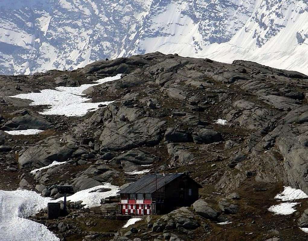
From Pont di Valsavarenche (1.960m) a comfortable mule track starts just behind the Hotel. Toward West into the narrow valley of the Doire Stream of Nivolè and, along a ramp, get the Croce de la Roley (2.313m), (good panoramic point). Follow zigzagging into the big banks of rock, polished by ancient glaciers, entering the Nivolè Plain, (a big highland long more than 6km ending with two fine lakes (2.526m and 2.537m) and the Nivolè Pass (2.612m) joining the Valsavarenche with the Ceresole Valley (Piemonte) Two Refuges here: Savoia 2.610m and Chivasso. Along this plain up to the many twists of the Doire Stream and, before the Montagna Grand Collet (2.409m). From the "Montagna Grand Collet" am gone through the torrent reaching immediately after the Mountain of the Nivolè (2.399m). Staying to east of the torrent it arrives at the Inferior Lake of the Nivolè (2.526m) and then with Southeast direction to the Superior one (2.772m) and on the easy and simple West Glacier to reach the Point Fourà Pass (3.124m). With direction south it ascend the crest on a wide slope and to reach the Shoulder Northwest; therefore following the thread arrives at the omit of traditional peak. It "true" peak is just more to high south a meter in more. It is reached it with an exposed passage after a carving of about three meters (II°+; 4h'30/5h'00).
Da Pont di Valsavarenche (1.960 m) prendere la comoda mulattiera che parte subito dietro l'Albergo; salire verso W lo stretto valloncello della Doire (torrente) del Nivolè e, con una rampa finale, raggiungere la Croce de la Roley (2.313 m), ottimo punto panoramico e fotografico. Si continua a serpentina tra grandi banconate di splendida roccia, levigata dall'antica erosione glaciale, "entrando" nel Pian del Nivolè, grande altipiano di oltre 6 km utile al pascolo; al termine dello stesso l'omonimo Colle (2.612 m), preceduto da due bei laghi (2.526 m e 2.537 m) porta nella Valle di Ceresole in Piemonte (Rifugi Savoia 2.610 m e Chivasso proprio al colle). Percorrere un tratto del famoso pianoro sin dove la Doire effettua numerose anse, raggiungendo la Montagna Grand Collet (2.409 m). Dalla Montagna Grand Collet si attraversa il torrente raggiungendo subito dopo la Montagna del Nivolè (2.399 m). Restando ad est del torrente si giunge al Lago Inferiore del Nivolè (2.526 m) e poi con direzione Sud-Est al Superiore (2.772 m). Sul facile e semplice Ghiacciaio Occidentale raggiungere il Colle di Punta Fourà (3.124 m) Con direzione sud salire la cresta su un largo pendio e raggiungere la Spalla Nord-Ovest; quindi, seguendo il filo, si giunge allo ometto di vetta tradizionale. La "vera" vetta è appena più a sud alta meno di un metro in più. La si raggiunge con un passaggio esposto dopo un intaglio di circa tre metri (II°+; 4h'30/5h'00).
Difficulty
The route can be classified as EE/F+.
L'itinerario è classificato EE/F+.
Gear
Normal hiking equipment. A rope is recommended.
Red Tape
Within the borders of the P.N.G.P. (Parco Nazionale del Gran Paradiso), at the moment dogs generally are not allowed, except on a couple of trails, and camping is forbidden (except for climbers from sunset till dawn). No fees are due.
"I Rifugi della Valle d'Aosta" di Stefano Ardito, Ed. Guide iter, Febbraio 2003.
"Parco Nazionale del Gran Paradiso" di Stefano Ardito, Ed. Guide iter, Novembre 2001.
"Guida delle Alpi Occidentali", di Giovanni Bobba e Luigi Vaccarone C.A.I. Sezione di Torino Volume II (parte II), 25 Maggio 1896.
"Gran Paradiso", A. Gegenfurtner, G. Klotz, F. Müller, Ed. Bergverlag Rudolf Rother, Monaco 1980 (in tedesco).
"Gran Paradiso", G. Klotz, Ed. Bergverlag GmbH Rother, Monaco 2005 (in tedesco).
"Diari Alpinistici" di Osvaldo Cardellina e Indice Generale accompagnato da Schedario Relazioni Ascensioni 1964-2019 (inediti).
"Rifugi e bivacchi in Valle d'Aosta", di Cosimo Zappelli aggiornata da Pietro Giglio, Musumeci Editore, Luglio 2002.
"Guida della Regione Autonoma Valle d'Aosta" di Mario Aldrovandi,Ed. S.P.E. di Carlo Fanton, Torino 31 Dicembre 1964.
"Guida dei Monti d'Italia-Gran Paradiso Parco Nazionale" E. Andreis, R. Chabod, M. C. Santis, Club Alpino Italiano/Touring Club Italiano, prima Ed. 1939; seconda Ed. 1963; terza Ed. 1980.
MAPS:
Kompass "Gran Paradiso Valle d'Aosta Sentieri e Rifugi" Carta Turistica 1:50.000.
L'Escursionista "Valsavarenche Gran Paradiso Carta dei Sentieri" (n° 9) 1:25.000.
Meridiani Montagne "Gran Paradiso" 1:25.000.
Enrico Editore Ivrea-Aosta "Gruppo del Gran Paradiso" 1:50.000.
L'Escursionista "Valle di Cogne Carta dei Sentieri" 1:25.000.
L'Escursionista "Tour de la Vallée de Cogne Grand Paradis" 1:25.000.
I.G.C. Istituto Geografico Centrale "Parco Nazionale del Gran Paradiso" 1:50.000.
Studio F.M.B. "Gran Paradiso" Bologna 1:50.000.
I.G.C. Istituto Geografico Centrale Torino "Valsavarenche Val di Rhêmes Valgrisenche P.N.G.P.", 1:25.000.
A.I.NE.VA. (Associazione Interregionale Neve e Valanghe).
Useful Numbers
Protezione Civile Valdostana località Aeroporto n° 7/A Saint Christophe (Ao) Tel. 0165-238222.
Bollettino Meteo (weather info) Tel. 0165-44113.
Unità Operativa di Soccorso Sanitario (Emergency Medical Assistance). Phone: 118.
Acknowledgements
I am greatly indebted to my friend I am greatly indebted to my friend "Osva" for the detailed description of the route. I am greatly indebted to my friend Gabriele Roth for the translation of the text from italian.
Parents refers to a larger category under which an object falls. For example, theAconcagua mountain page has the 'Aconcagua Group' and the 'Seven Summits' asparents and is a parent itself to many routes, photos, and Trip Reports.

 9682 Hits
 85.87% Score
 21 Votes


p-mike - Aug 4, 2016 4:27 pm - Voted 10/10
Punta Fourà will not be any longherPunta Fourà will not be any longher "fourà"...unfurtunately the characteristic hole is disappeared after a crash at the end of June 2016...
Antonio Giani - Aug 5, 2016 1:23 am - Hasn't voted
Re: Punta Fourà will not be any longherUn vero peccato... Ciao Antonio