


-
 3760 Hits
-
 81.18% Score
-
 13 Votes
|
|
Area/Range |
|---|---|
|
|
45.73410°N / 7.81195°E |
|
|
Hiking, Mountaineering |
|
|
Spring, Summer, Fall, Winter |
|
|
Note
La montagna chiama i suoi figli, ed essi rispondono fedelmente al suo appello… Osvaldo Cardellina, Diario alpinistico, 1964-65 Page texts: @ OsvaldoCardellina "Osva", passed away on May 2, 2022. Page owners: Christian Cardellina e Osvaldo Cardellina. Any updates from September 12, 2022: Antonio Giani, page administrator, friend and climbing companion. Testi della pagina: @ OsvaldoCardellina "Osva", scomparso il 2 maggio 2022. Proprietari pagina: Christian Cardellina e Osvaldo Cardellina. Eventuali aggiornamenti dal 12 settembre 2022: Antonio Giani, amministratore della pagina, amico e compagno di salite. |
Approaching below Mont Néry Overview
 |
Coming from Verrès Municipality, immediately before the Basin Estoul (directly above the Commune of Brusson) meet the small but ancient Village of Archésaz or Arcesaz (1.146m), which is the gateway to the above and along the Frudiera Walloon below the Northern Faces of Mont Nery or Nery, also known as Becca Frudiera (3.076m). We're taking the long Ayas Valley or Torrent Evançon that comes from the more Western Glaciers of Monte Rosa, beneath the high peaks of the Lyskamms. Immediately after Arcesaz the junction 1.145 meters (Roman name with "Arcus-Coesus" ie Arch Cut, while Brusson was "Bruxeum"; just beyond and above the Regional Road in locality Ciamousira or Chamosiraz 1.375 meters there is the old gold mine with rock crystals) part a Municipal Road that reaches Villages Curien (1.245m) and Graines (1.383/1.396m), the latter immediately preceded by its ancient Castle with squared Tower (1.313m). From here starts (sign of ban on driving cars) a private dirt farms road that reaches, first toward the Northeast, the Ruine Pastures (1.474m, 1.568m), under the homonym Mount; the same then heads East towards Alp Ponteille (1.553m), at the Torrent Chamen, to finally flex decisively towards Southeast achieving progressively in Southeast the Pastures Charbonnière, Collet, Restol, Pichiou, Rovetta and Champ Charlec (1.766m). Just beyond, between two other unnamed alpages, the same ends, while part of the path n° 9, which reaches almost immediately the small Village Frudière (1.849m; source with fountain). We're going to get from the media to the top of the Frudiera Walloon and, after reaching another alp with the name of Pichiou (1.942m; not to be confused with the previous year under the Pointe de la Garda), the trail turns sharply to the South while another secondary unnumbered proceeds on the bottom of the walloon (more direct but certainly more difficult and therefore cheaper) to reach the Alp Chatelet (2.027m). From here another change of direction at first South and then more toward Southeast decidedly East-northeast leads to the first of the two Lakes Frudiera, the largest (2.035m, E; 1h'30/2h'00 from the cartel prohibition after Graines) and on the Western slopes of Mont Taf (2.623m); through a circular tour along the South shore and then in the direction of the Northeast, winning a small rocky rampart which overlooks it, you will soon reach the second (2.230m) and in a short time the Frudiera Pass or Frudièrecoll (2.265m, EE; 0h'40 from first lake; 2h'15/2h'45 from start), located between the Mont Taf in North and West antetop Becca Frudiera or Mont Nery (3.026/7m), between this walloon and this of Forca in Valley of Gressoney above Pont Trenta Hamlet.

Arrivando da Verrès, subito prima della Conca di Estoul (direttamente sopra il Comune di Brusson) incontriamo il piccolo ma antico Villaggio d'Archésaz o Arcesaz (1.146 m), che costituisce la porta di ingresso al soprastante e lungo Vallone di Frudiera posto alle pendici Settentrionali del Mont Néry o Nery, detto anche Becca di Frudiera (3.076 m). Stiamo percorrendo la lunga Valle di Ayas o del Torrente Evançon proveniente dai Ghiacciai più Occidentali del Monte Rosa, sotto l'alte vette dei due Lyskamms. Subito dopo Arcesaz al bivio 1.145 metri (denominazione Romana con "Arcus-Coesus" cioé Arco Tagliato, mentre Brusson era "Bruxeum"; appena più avanti e al di sopra della Strada Regionale in località Ciamousira o Chamosiraz 1.375 m esiste la vecchia miniera aurifera con cristalli di rocca) si diparte una Strada Comunale raggiungente i Villaggi di Curien (1.245 m) e Graines (1.383/1.396 m), quest'ultima subito preceduta dal suo antico Castello con torre quadra (1.313 m). Da questa località inizia (cartello di divieto di transito per le auto) una strada poderale che raggiunge, dapprima verso Nordest, le Alpi Ruine (1.474 m, 1.568 m), sotto l'omonimo Monte; la stessa poi si dirige a Est verso l'Alpe Ponteille (1.553 m), presso il Torrent Chamen, per infine flettere decisamente verso Sudest raggiungendo progressivamente gli Alpeggi di Charbonnière, Collet, Restol, Pichiou, Rovetta e Champ Charlec (1.766 m). Appena oltre, tra due altri innominati alpeggi, la stessa termina, mentre parte il sentiero n° 9 che raggiunge quasi subito il piccolo Villaggio di Frudière (1.849 m; sorgente con fontanile). Stiamo per entrare dalla parte media a quella superiore del Vallone di Frudiera e, dopo aver raggiunto un altra alpe con il nome di Pichiou (1.942 m; da non confondere con la precedente sotto la Pointe de la Garda), il sentiero piega decisamente a Sud, mentre un altro secondario non numerato procede sul fondo del vallone (più diretto ma sicuramente meno agevole e quindi conveniente), raggiungendo l'Alpe di Chatelet (2.027 m). Da qui un altro cambio di direzione dapprima più verso Sudest e poi decisamente ad Est-nordest conduce al primo dei due Laghi di Frudiera, il più grande (2.035 m; E; 1h'30/2h'00 dal cartello di divieto dopo Graines) e posto alle pendici Occidentali del Mont Taf (2.623 m); tramite un giro circolare lungo la sponda Sud e poi con direzione Nordest, vincendo un piccolo spalto roccioso che lo domina, in breve si raggiunge il secondo Lago (2.230 m) ed in breve tempo il Colle di Frudiera o Frudièrecoll (2.265 m; EE; 0h'40 dal primo lago; 2h'15/2h'45 dalla partenza), posto tra il Mont Taf a Nord e l'antecima Ovest della Becca di Frudiera o Mont Néry (3.026/7 m), tra l'omonimo vallone e quello di Forca in Val di Gressoney sopra il Villaggio di Pont Trenta.
BY CAR:
- From TORINO, MILANO, etc: Motorway A5. Exit at IVREA or Quincinetto (PIEDMONT) From IVREA Town: in West (Southern side) to Pont Saint Martin, Verrès Municipalities in East from Aosta Town. From Courmayeur Resort: in East-southeast to Aosta, Nus, Chatillon, Saint Vincent, Verrès Municipalities.
- From Verrès to Val d'Ayas Valley From Verrès (549m), with Regional Road, to Challant Saint Victor (765m), Challant Saint Anselme (1.060m), Archésaz Hamlet (1.146m), Brusson (1.332m) Municipalities; wanting, continuing to Northwest to Antagnod-Ayas (1.709m) Commune, below Mounts Tantané and Zerbion also in North towards Champoluc (1.570m) and Saint Jacques(1.670m) Communes at the end of Evançon or Ayas Valley and under the Western side of Monte Rosa (Rollin Hump, Breithorns, Pollux and Castor).
- From FRANCE: through the Mont Blanc Tunnel to Entrèves/Courmayeur. By Little Saint Bernard Pass, closed since November until half May to La Thuile Valley - Pré Saint Didier - Aosta - Verrès Municipalities. It is not necessary to take Motorway A5: you can drive on SS.26, in the direction of AOSTA - IVREA - TURIN.
BY PLANE:
- Aeroporto "Corrado Gex" Saint Christophe (Aosta).
Summits & Passes
2) - Garda West-northwestern Hill or Saddle (2.163/6m). From Fenêtre Alp (2.083m) through the path n° 9A before in Southeast, after South to large saddle, between Punta della Regina and Punta de la Garda. Variant: from Arescoll through the unnumbered path in Southwest to junction with previous route neighbor the upper part of Reine Torrent (T/E/F; 0h'30/0h'40 from the both or 1h'15/1h'30 from the parking of Resort).
3) - Pointe de la Regina (+; 2.387m). From Ranzola Hill E/F; 0h'30/0h'40). Also from Garda East-southeastern Hill also Gombetta Pass (0h'20).
4) - Garda East-southeastern Hill also Gombetta Pass (2268m). From Arescoll with easy descent crossing in Southeast to point 2.145 meters; from this with Southwestern direction to mini pond 2.186 meters and Hill (E/F; 1h'00/1h'10 from Ranzola Hill; 2h'30/3h'00 Estoul).
5) - Mont Rena also Wisomattòspétz (+; 2512m). From Ranzola Hill through paths n° 3B/3A to the Garda Southeast Hill (E/F; 0h'30); from this to small Saddle of Pra Bianco (around 2.400 meters; not to be confused with the Pra Bianco Pass (2.331m), just to the East. Signals and path-traces) and with small path and following debris traces on the North-northwest Ridge to Summit (EE/F+; 1h'10/1h'20 from Ranzola Hill).
6) - Mont Taille (2.561m) and nearby Weissmatten (2.456m).
a) - From Rena with traverse in crest and, after a small carving 2.492 meters, circumventions to the Western Face Mont Taille or with rock climbing;
b) - continue East on terminal crossing on Western Crest of Weissmatten. Remark: the entire crossing of these three Summits requires experience and prudence because, although the path is signaled, the same spread for about a Kilometer through grassy slopes very steep and exposed to the West, Southwest, South-southwest and the overcoming of rocks not difficult (I°/I°+) but often crumbling and rotten; is more a path to chamoises Hunters rather than suitable for Hikers. Be avoided altogether in snow presence, especially when it is fresh and tends to glide over the grassy slopes (EE/A; F to F +; 1h'15/01h'45 for the both complete traverse).
7) - Mont Taf (2.623m). From Mont Rena with traverse on ridge to the Sout-southeast on North-northwest Ridge, discarding West the Mont Taille (EE/F+ 1h'30/2h'00 from Ranzola Hill. Also from Frudièrecoll before through path n° 1A up to the point 2.416 meters (continuation of the same with descent towards Petersch Gombò and Gressoney), after along Southeast short Crest with easy but exposed route (EE/F+; 1h'00/1h'15).
8) - Frudièrecoll or Frudiera Pass (2.265m). Starting Graines Village with hemi circular route on dirt road and path to first lake; from this to second Frudière Lochs and Western Slope in terminal part (EE; 0h'40 from the first Frudière Lake; 2h'15/2h'45 from departure by Graines).
 |
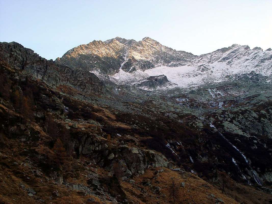
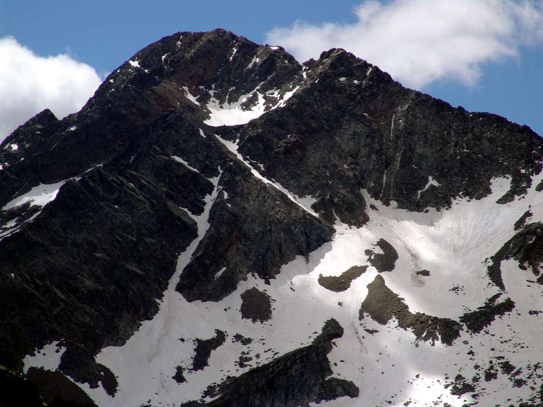
10) - Mont Néry also Becca di Frudiera (+ 3.075m). We list all the routes starting from the East, North and West into the Basin of Frudière:
a) - From Graines to Frudière Alpage and to the more great Frudière Loch; after through Northern Slope of large Saddle about 2.890/5 meters and West Ridge to the Western Ante Top (3.027m) and Top (A/F+; from PD- to PD; 2h'45/3h'15 from Lake; 5h'15/5h'45 from Graines Village).
b) - Through Northwestern Face of Ante Top 3.027 meters, upper snowfield, small triangolar wall and West Ridge in final part, by Guido De Rege and Giuseppe Wuillermin in July 1925; first winter Emilio Cappelli and Alberto Linty in February 26/27th, 1965 and first solo by Pier Luigi Ferrero May 02th, 1987; all the ascents through the left gully of around 250/60 meters in final part below the West Ridge (A/PD+/AD-; 2h'30/3h'00).
c) - Through Northern E'peron to Ante Summit 3.027 meters and West Ridge. From Frudièrecoll or from two Frudière Lakes directly on North small Spur, by Giulio and Tito Zanetti in July 31th, 1923, with passages from I°//II°/II°+ up to III°-/III° along 600 meters (A/PD+; 3h'00/3h'30).
d) - Through Northern great snowfield (27°/32°), triangular snowfield (33/35°), little gully (36°/38°) to Western Ridge, between Ante Top 3.027 meters and the Summit, and final easy climbing by the same (A; from F to F+; 2h'30/2h'45 from Frudière Pass; 5h'00/5h'30 from Graines).
e) - From Frudèrecoll through a large snowfield (27°/30°) on Northern Slope and rowards North-northeast Crest in superior sector (in the last quarter of the ridge) and Western Ridge in terminal part, by Edoardo Ferrero, lone in Summer 1984 (A/F/F+; 2h'00/2h'15 from Frudière Pass).
f) - From Frudèrecoll through Northern Slope and directly to Summit on North Rib, by Osvaldo Cardellina, solo in October 05th, 2002, with passages from II° to III°+ (A/PD+/AD-; 3h'30/4h'00 Frdièrecoll; PD+/AD-; 2h'15/2h'30 from the rocky base in the last around 230/40 meters).
g) - From Frudèrecoll through Northeast Crest from the collar around 2.680 meters, between Marienhorn and Mont Nery, by Pier Luigi Ferrero, solo in Summer 1985, with passages from I°+ to II° (partially route by via with different workarounds South, below the edge of the Crest); (A; from F+ to PD; 3h'30/4h'00 pass; 2h'00/2h'15 from collar). Still not made in integral; probably challenging with exposed climbing on not good rock.
11) - Mont Solaron or Punta di Soleron (2.888m). From the first Frudière Loch through large Saddle about 2.895 meters and Southeast Crest.
12) - Pointe Champ-Long or Champlon (2.671m). From Mont Solaron through crossing and East-southeast Ridge.
13) - Fourchette or La Forchetta also Nanta Pass (2.202m). From Frudière Alpage or from Chatelet Pond without paths.
14) - Cleve de Moula (2.241m). From Restol or Restoly (1.682m) or from Champ Charlec (1.766m) Alpages through two paths n° 9C passing on Balavra Alp (1.881m) or more to the East with dirt road to Rovetta (1.777m), Chavanne (1.871m), Oreille (1.991m) and next unnamberede path to previous route, passing under Merian Alpage (2.019m). Possibility of descent always with path to Moula Alp (1.885m) into nearby Chasten Walloon.
15) - Becca di Meriau or Bec de Merian (2.177m). From Restol pasture through the Forest on Northern Slopes, pathless, also with crossing from Cleve de Moula by Southeast brief Crest.
Approaching to Lakes & Frudièrecoll
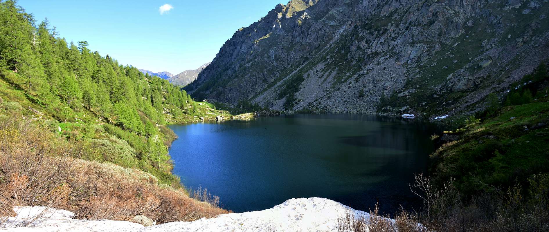
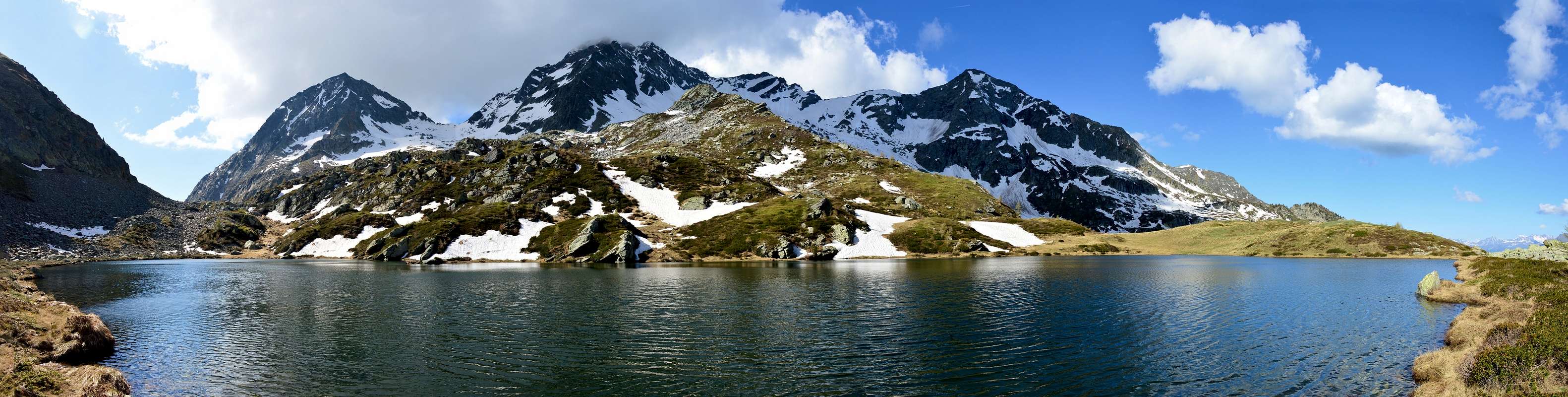
The Lakes Frudière, unlike those of the Conca (Basin) Estoul that are quite numerous among the Walloons Bringuez, Palasinaz, Freide and Estoul, are only two in number and located at the end of the Walloon namesake, just below the pass or Frudièrecoll. The first lake you come to is the Lower but that, with a play on words, it is the largest and most extensive; place the altitude of 2.035 meters above possesses a surface area of 880.770 square meters, compared to a length of around 422 meters and a width of around 260 meters. Just above, after a rocky and grassy pastures with two unnamed and now semi ruined (2.116m, 2.273m; see under the photographs) is the second less large lake or Higher (2.230m), approximately one-tenth less in size and located on the Southwest slopes of the Mount Taf (2.623m). A third mini pond is located on the Western side of the latter. From these the last stretch of the path n° 9 leads to Pass of Frudiera (2.265m) to the Valley of Gressoney, or that the Lys from the name that gives you the Torrent.
 |
 |
 |
 |
 |
 |
 |
 |
 |
 |
 |
 |
 |
 |
 |
 |
 |
 |
 |
 |
Campings
Remember that free camping is forbidden (except for emergency reasons, over 2.500m, from darkness until dawn).
Mountain Conditions
- You can get meteo information at the official site of the Regione Valle d'Aosta:
- Valle d'Aosta Meteo
- Meteo: You can find more weather information on the website 3B Meteo:
- Meteo Brusson
Books and Maps
BOOKS:
- "Guida delle Alpi Occidentali" di Giovanni Bobba e Luigi Vaccarone C.A.I. Sezione di Torino Volume II (parte II), 25 Maggio 1896.
- "Guida dei Monti d'Italia" Alpi Pennine (Vol. 2) di Gino Buscaini - Club Alpino Italiano/Turing Club Italiano, Luglio 1970 (In Italian).
- "Val d'Ayas itinerari escursionistici" di Piergiorgio Bosio Ed. Musumeci, Giugno 1983.
- "A piedi in Valle d'Aosta" (Vol. 2), di Stefano Ardito, Ed. Guide iter, Giugno 2004.
- "Gressoney itinerari escursionistici" di Piergiorgio Bosio Ed. Musumeci, Giugno 1984.
- "Alpinismo e Escursionismo in Val d'Ayas" di Giorgio Merlo, Ed. CDA Torino Maggio 1984.
 |
 |
 |
 |
MAPS:
- Meridiani Montagne "Monte Rosa" Carta 1.50.000 con carta di dettaglio 1.20.000.
- L'Escursionista "Val d'Ayas Val di Gressoney Monte Rosa" Carta dei sentieri (n° 8) 1:25.000.
- Comunità Montana Evançon "Carta dei sentieri" (n° 2), 1:30.000.
- Kompass "Breuil/Cervinia-Zermatt" Carta turistica 1:50.000.
- I.G.C. Istituto Geografico Centrale Torino "Cervino e Monte Rosa" 1:50.000.
Important Information
- REGIONE AUTONOMA VALLE D'AOSTA the official site.
- FONDAZIONE MONTAGNA SICURA Villa Cameron, località Villard de la Palud n° 1 Courmayeur (AO) Tel: 39 0165 897602 - Fax: 39 0165 897647.
- A.I.NE.VA. (Associazione Interregionale Neve e Valanghe).
Useful numbers
- Protezione Civile Valdostana località Aeroporto n° 7/A Saint Christophe (Ao) Tel. 0165-238222.
- Bollettino Meteo (weather info) Tel. 0165-44113.
- Unità Operativa di Soccorso Sanitario Tel. 118.