
|
|
Mountain/Rock |
|---|---|
|
|
40.92502°N / 111.85299°W |
|
|
Davis |
|
|
Hiking |
|
|
Spring, Summer, Fall, Winter |
|
|
6470 ft / 1972 m |
|
|
Overview
After leaving the trail, head up the side of the mountain to the peak

Peak 6470 is located directly east of Centerville Utah and over looks the town. There isn't an official name that I know of but the locals will sometimes call it "ZigZag Hill" or confuse it with Centerville Peak (8904) 2 miles to the east. It is one of dozens of low-level peaks along the Bonneville Shoreline trail and is probably the most accessible of these “junior” peaks from Salt Lake City to North Ogden. This is an excellent peak if you have a half day to kill or don’t want to press toward Centerville Peak, another 4 miles along the trail. It is kid-friendly and doesn’t present any technical aspects, even the final scramble is pretty easy.
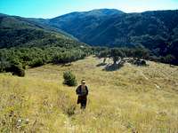
The trip to the top includes Gambel Oak scrub forest, rocky terrain, a large grass meadow and a couple of steep climbs, all on a well-maintained trail. The last hundred yards to the top involves a scramble up the side of the mountain up a rocky, grassy hillside. Once on top, you’ll be rewarded with a nice view of the Great Salt Lake, Centerville, with steep canyons on both sides of the top. Most of trail goes up the west face and has little forest cover. About a mile up, the trail routes goes high above Centerville Creek canyon and is a pretty neat view of the canyon below. The trail is hot and dry during the summer…bring water as there isn’t any sources along the way. During the winter, the trail should be doable wearing “Yak-track” walking crampons (or good boot tread) although snowshoeing could be entertaining too.
Route to the Top

The final scramble to the top

Park at Parrish Creek and follow the trail up the hill. There are a number of trails right out of the parking lot but you can’t go wrong heading “east” and “up”. There are a bunch of signs advising hikers to stay on the trail to cut down freelance trail making. Please don’t take shortcuts. The main trail is in nice condition, so all trailblazing does is mess it up for the next guy. The first part of the trail is steep until it reaches a large few grassy meadow. From there, the trail continues to the zig-zag up the up. After following the switchbacks, you’ll reach a small forest and the trail turns South (and runs along the West face of the hill). At almost exactly half-way, there is an obvious place to take a break on some boulders. From the boulders, the trail takes a right and runs South East. From here you can see Centerville Creek Canyon far below. Looking down into the canyon you’ll note an American Flag flying in the canyon on one of the crags—nice patriotic inspiration for going to the top! The trail again goes through light scrub and you can see the Peak 6470 on your left. The best place to scramble to the top is across from a nicely developed camp. A couple of inspired zigzags, a hundred yards up the hill for the scramble and you are on top of Peak 6470.
Distance from the trailhead to the top of 6470 is a little more than 2 miles. However, if you are a true professional and continue on the trail, you’ll reach Centerville Peak in about 4 more miles past 6470. Total elevation gain is around 1,870 feet(or about 900 feet per mile).
Getting there
The closest trailhead is located at Long/Lat 40.922406,-111.866194. From I-15, take the Parrish Lane Exit (319) to Centerville. Follow Parrish Lane east past Target, Wal-Mart, and DQ (difficult task if you have wife/children). Continue on Parrish Lane to where it comes to a T at 700 East. Turn left (north) onto the windy and narrow road, watching out for idiots in large vehicles. Park in the big, dirt parking lot.There aren't any restrooms or water available at the trailhead (nor is there any along the route), so plan accordingly. The trailhead parking lot is big enough to accommodate horsetrailers and has space for about 15 vehicles.
Red Tape
There isn't any red-tape that I know of. You are on forest service land for the whole hike. Be careful with any fires (they are prohibited during the summer) as the entire mountainside is a forest fire waiting to happen. In addition, the USFS cautions you about disturbing the wildlife (particulary deer and moose) during calfing season. There is a kiosk signboard at the trailhead with cautions/warnings and a map.Camping

Camping area next to peak
There isn't any really good spots along the route until you are nearly to Zig-Zag peak. Right a the base, there is one really nicely developed (and used) primitive camp site before scrambling to the top. There isn't any water available at any point in the hike, so you are stuck packing in any drinking materials you desire. As to the camp spot, I have yet to see it occupied, but since there seems to be a lot deer in the area, it probably gets used during deer season in the fall.
Flora and Fauna

Most of the Flora is typical Utah dry climate. There are pretty wildflowers in the spring, two large grassy meadows, Gambel Oak, Canyon Maple and Sagebrush.
Keep your eyes out for squirrels, deer, moose and rattlesnakes along the way.