
-
 54564 Hits
-
 95.63% Score
-
 54 Votes
|
|
Area/Range |
|---|---|
|
|
46.37800°N / 10.56710°E |
|
|
Hiking, Mountaineering, Trad Climbing, Ice Climbing, Mixed, Scrambling, Skiing |
|
|
Spring, Summer, Fall, Winter |
|
|
12812 ft / 3905 m |
|
|
1 - Overview
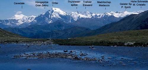 The Ortler / Ortles Group seen from above Sesvenna Hut
- Vinschgau / Val Venosta and Münstertal / Val Müstair in the north
- Val Pescara and Marauntal / Val Marano in the east
- Val di Sole and Val Vermiglio in the south
- The line Bormio - Passo di Gavia - Ponte di Legno in the west
| 
| 
|
2 - The Ortler / Ortles Group on SP

- Fallatschkamm / Cresta Vallazza (this page)Fallatschkamm / Cresta Vallazza (separate page)
- Umbrail Group (this page)Umbrail Group (separate page)
- Kristallkamm / Cresta del Cristallo (this page)Kristallkamm / Cresta del Cristallo (separate page)
- Ortlerhauptkamm / Cresta Principale dell'Ortles (this page)Ortlerhauptkamm / Cresta Principale dell'Ortles (separate page)
- Laas - Marteller Kamm / Gruppo Vertana-Angelo-Lasa (this page)Laas – Laas - Marteller Kamm / Gruppo Vertana-Angelo-Lasa (separate page)
- Cresta Confinale
- Marteller Hauptkamm / Cresta Principale di Martello (this page)Marteller Hauptkamm / Cresta Principale di Martello (separate page)
- Cevedale – Vioz – San Matteo (Forni) Group (this page)Cevedale – Vioz – San Matteo (Forni) Group (separate page)
- Creste di Peio e Rabbi
- Ultentalkamm / Cresta Val Ultima (this page)Ultentalkamm / Cresta Val Ultima (separate page)
- Saboretta - Gavia Group (this page)
3 - Fallatschkamm / Cresta Vallazza
Terrain map of Fallatschkamm / Cresta Vallazza |
4 - Umbrail Group
Terrain map of the Umbrail Group |
5 - Kristallkamm / Cresta del Cristallo
Terrain map of Kristallkamm / Cresta del Cristallo |
6 - Ortlerhauptkamm / Cresta Principale dell'Ortles
Terrain map of Ortlerhauptkamm / Cresta Principale dell'Ortles |
7 - Laas - Marteller Kamm / Gruppo Vertana-Angelo-Lasa
Laas - Marteller Kamm / Gruppo Vertana-Angelo-Lasa |
8 - Cresta Confinale
Google Terrain map of Cresta Confinale. Zoom in to see the mountain names.
Cresta Confinale is the smallest of the subgroups of the Ortler / Ortles Group and is often considered to be part of Ortlerhauptkamm, the main ridge around the highest summits of the range. However, it is separated from the main ridge by Valle dello Zebrú and connects to it only by Passo del Zebrú. The northern boundary is the already mentioned Valle dello Zebrú, the western one is Valfurva, the southern boundary is Valle dei Forni, while the eastern one is Valle di Cedec.
Cresta Confinale is a single ridge running west to east, which culminates in Monte Confinale (3370m). It contains a number of smaller, quickly vanishing glaciers on its northern side.
- Monte dei Forni (3035m)
- Sasso Prealda (2709m)
- Sasso di Manzina (2920m)
- Cime dei Forni (3247m, 3240m, 3232m, 3227m)
- Cima della Manzina (3318m)
- Monte Ables (3137m)
- Monte Confinale (3370m)
- Cima delle Saline (3073m)
- Piccon di Saline (2995m)
- Monte Forcellino (2842m)
9 - Marteller Hauptkamm / Cresta Principale di Martello
Google Terrain map of Marteller Hauptkamm/ Cresta Principale di Martello. Zoom in to see the mountain names.
The largest subgroup of the large Ortler / Ortles Group is located at its north-western end. It is a single ridge, which stretches from the central part of the range, i.e. from the vicinity of Monte Cevedale, all the way to the north-west, where it ends right above the city of Meran / Merano. It is wedged between Ultental / Val d'Ultimo in the south, lower Vinschgau / Val Venosta in the north and Martelltal / Val di Martello in the west. From this latter valley, or rather the village at the mouth of it the subgroup derives its name: Marteller Hauptkamm. Literally translated, this would be Cresta Principale di Martello in Italian or Martell Main Ridge in English.
The crest stretches some 25km from WSW to ENE with the highest mountains, all 3000ers, at one end from where elevations gradually drop until they reach some 1600m before finally dropping into the Etsch / Adige basin above Meran / Merano. Consequently the different parts of the range are very different and activities also vary a lot. While in the higher parts there are only few hiking trails and most mountains are reserved for alpinists the western parts of the ridge are wonderful hiking grounds with a huge network of trails. In winter, however, all parts of the subgroup attract tour skiers and there is many a mountain which gets ascents in the wintertime.
For More information see the Marteller Hauptkamm / Cresta Principale di Martello Page10 - Cevedale – Vioz – San Matteo (Forni) Group
Google Terrain map of the Cevedale - Vioz - San Matteo Group. Zoom in to see the mountain names.
Almost all of the mountains of this subgroup are located on two ridges, which together appear to be S-shaped. Valle del Monte separates the ridges. The northern main ridge runs from Cevedale southward to Monte Vioz, turns west, passing the mighty Ghiacciaio dei Forni (Forni Glacier) to Punta San Matteo, from where it reaches its endpoint, Corno dei Tre Signori, the westernmost mountain of the group. The south ridge first runs south-eastward along the Ercavallo Crest towards Forcellina di Montozzo from where it heads north-westward across Monte Redival towards Peio. The mountains on the south ridge are far less important than the northern ones.
For more information see the Cevedale - Vioz - San Matteo (Forni) Group Page11 - Cresta di Peio e Rabbi (Cresta Carreser)
Google Terrain map of the Creste di Peio e Rabbi. Zoom in to see the mountain names.
Located between the Valleys of Pejo and Rabbi this subgroup is a single crest running from the centre of the Ortler / Ortles Group towards Val di Sole in the south. It has its start at Bocca di Saent, where several of the subgroups meet. The saddle is the most important pass in the half circle of mountains which circle Moosferner / Vedretta di Careser one of the most important glaciers of the range.
The highest mountain, Cima Careser, also is part of that half-circle of mountains, and but for Cima Mezzena the northernmost mountain of the subgroup. The crest runs north to south but at Cima Vegaia, east of Pejo, it turns eastward and runs out above the mouth of Valle di Rabbi, above Male. The south of the group is a popular hiking area, thanks to wide pastures on the south slopes and the area of glacier lakes around Lago Rotondo, which can be easily reached from Rabbi.
- Cima Mezzena (3172m)
- Cima Careser (3188m)
- Cima Campisol (3159m)
- Cima Lagolungo (3165m)
- Cima Ponte Vecchio (3162m)
- Cima Cavaion (3120m)
- Cima Verdignana (2938m)
- Cima Ganani (2889m)
- Cima Vallon (2892m)
- Cima Grande (2901m)
- Cima Cadinel (2864m)
- Cima Vegaia (2890m)
- Monte le Pozze (2773m)
- Cima Bassetta (2770m)
- Cima Tremenesca (2726m)
- Monte Polinar (2604m)
- Cima Valetta (2828m)
- Cima Mezzana (2845m)
- Monte Saleci (2680m)
- Monte Gamberai (2423m)
- Camucina (2636m)
- Sass dell’Anel (2368m)
- Monte Camucina (2287m)
12 - Ultentalkamm / Cresta Val Ultima
Google Terrain map of Ultentalkamm / Cresta Val d'Ultimo. Zoom in to see the mountain names.
Ultental / Val d'Ultimo stretches deep into inside the Ortler / Ortles Group from the east. It starts at Lana near Meran / Merano and ends in several branches near the central part of the greater Group. The most important of these branches is Kirchbergtal / Val Montechiesa, which ends in Passo di Rabbi. Ultental / Val d'Ultimo is accompanied by two long ridges, which are both considered subgroups of the Ortler / Ortles Group: Marteller Hauptkamm / Cresta Principale di Martello in the north and west and Ultentalkamm / Cresta Val d'Ultimo in the south.
Ultentalkamm / Cresta Val d'Ultimo, much like its northern counterpart, starts in the south-east, close to the centre of the Ortler / Ortles Group. It is separated from Marteller Hauptkamm / Cresta Principale di Martello by Schwarzer Joch / Giogo Nero, an only slightly pronounced saddle at 2822m. Right to the south of the saddle you can find the highest mountain of the group, Gleckspitze / Collechio (2957m). Unlike the northern subgroup, however, it is composed of several ridges, all separated by the important passes of the group. The northern boundary, quite obviously, is Ultental / Val d'Ultimo, the southern boundaries are Valle di Rabbi and Val di Sole while the eastern boundary is composed by Val Pescara and Marauntal / Val Marano. These latter valleys separate the Ortler / Ortles Group from the Nonsberg Group and it is here that the Peradriatic Fault separates the North-African from the Eurasian tectonic plate.
For More information see the Ultentalkamm / Cresta Val d'Ultimo Page13 - Sobretta - Gavia Group
Google Terrain map of the Sobretta - Gavia Group. Zoom in to see the mountain names.
As mentioned in the overview section, the Sobretta - Gavia Group (Italian Gruppo Gavia - Sobretta - Serottini) used to be considered part of the Ortler / Ortles Group up to 1984, when a new convention of the groups of the eastern Alps was defined, after which the range is ranked as standalone group. For the time being - and until a group page will be put up the Sobretta Gavia Group will find a home here. The group is named after its two (three) cornerstone mountains, Monte Sobretta in the north, Monte Gavia in the east and Monte Serotttini in the south-west.
Its boundaries are Valtelina / Veltlin to the west, the line Bormio - Passo di Gavia - Ponte di Legno in the east and Valcamonica to the south. The group is divided into two parts by Valle di Rezzalo and Valle dell Alpe, which connect in Passo dell Alpe. The northern part is shaped like a horseshoe with Monte Sobretta at its apex. The southern part is a long ridge starting at Passo di Gavia and ending at Dosso Signeul, thus running from north-east to south-west. Several important side ridges stretch from Cima di Savoretta towards the south-east.
- Cima Bianca (3018m)
- Monte Vallecetta (3148m)
- Monte Oultoir (2648m)
- Monteur (3007m)
- Monte Mala (2943m)
- Dosso Sobretta (2617m)
- Monte Sobretta (3296m)
- Corno di Profa (3069m)
- Punta di Polore (2925m)
- Cima di Profa Alta (2907m)
- Corno di Boéro (2878m)
- Cima di Gavia (2991m)
- Monte Gavia (3223m)
- Savoretta Tonda (3010m)
- Cima di Savoretta (3096m)
- Monte dei Poltron (2702m)
- Cima delle Pozze (2656m)
- Punta di Pietra Rossa (3212m)
- Cima Monticello (3161m)
- Punta di Monticelli (2636m)
- Monte Coleazzo (3006m)
- Cima Bleis di Somathosco (2638m)
- Cime di Pietra Rossa (2679m, 2867m, 2992m)
- Cime di Giere (2776m, 2739m, 2747m)
- Cime del Tirlo (2786m, 2829m, 2861m)
- Cima Mattaciul (2852m)
- Monte Bles (2826m)
- Cimini della Torre (2236m)
- Cima Muralta (2521m)
- Cime delle Relle (2519m)
- Cima Revala (2517m)
- Trottanera (2367m)
- Pulpito (2430m)
- Corno dei Becchi (2822m)
- Corno Dombastone (2623m)
- Sasso Maurone (2722m)
- Sasso Grande (2673m)
- Corno Tremoncelli (2834m)
- Corni di Cevole (2783m)
- Monte Tremoncelli (2724m)
- Corno del Ormacciolo (2409m)
- Monte Serottini (2961m)
- I Dossoni (2910m)
- Monte Seroti (2643m)
- Cime di Grom (2773m)
- Punta Alta alla Croce (2501m)
- Monte Varadega (2634m)
- Monte Resverde (2347m)
- Piz de la Casüce (2273m)
- Dosso Signeul (1952m)
14 - Getting There
As the Ortler / Ortles Group is huge itineraries can be long and depend on the final destination.14.1 - Northern access
The easiest way to reach the Ortler / Ortles Group from the north is from the Vinschgau Valley / Val Venosta. Two valleys cut more or less deep into the group: Martelltal / Val Martello and Suldental / Val di Solda. You can reach the area from Brenner Motorway A12 via SS38 from the exit Bozen Süd / Bolzano Sud. Northern access (from Austria) runs across Reschenpass / Passo di Resia via SS40.14.2 - Eastern access
There is only one valley, which leads into the Ortler / Ortles Group from the east: Ultental Val d'Ultimo. You reach it most easily from the Brenner Motorway A12, taking the exit Bozen Süd / Bolzano Sud, and using SS38. Take the exit Lana, drive through the town, following the signs for Ultental / Val d'Ultimo.14.3 - Southern access
Val di Sole, which runs towards Passo Tonale, together with Valle delle Messi forms the southern boundary of the group. Three valley cut into the group: Valle di Peio, Valle di Rabbi and Valle di Bresimo. From Brenner Motorway A12 it can be reached taking the exit San Michele all'Adige using SS43, later SS42. From Bergamo SS42 leads all the way to Ponte di Legno and Passo Tonale.14.4 - Eastern access
The eastern part of the Ortler / Ortles Group is most difficult to reach due to the fact that only narrow valleys lead there, often across famous passes. There is no major highway in the area. Access from the north is through Vinschgau Valley / Val Venosta (see above) and across Stilfser Joch / Passo dello Stelvio using SS38. From the south follow SS42 from either side to Ponte di Legno, then switch to SS300 which runs along the east of the group.15 - 13 Summits Tour
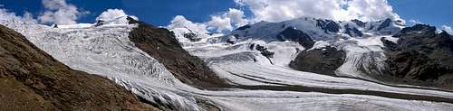 Ghiacciaio dei Forni
15.1 - Day One: From Passo di Gavia to Bivacco Meneghello (3-4 hours, PD+)
From Santa Canterina Valfurva (Valtellina - Italy) take the car (bus / taxi) Passo di Gavia. Start on the normal route to Pizzo Tresero (3594m), passing Bivacco Seveso and using the south-west ridge of the mountain. A rocky traverse leads to Punta Pedranzini (3599), and on to Cima Dosegù (3560m) with a beautiful view of the San Matteo north face. Turn south-east onto a short but rocky ridge (in poor visibility head further south across easy rocks). An easy snow-ridge of 45° leads to Punta San Matteo (3678m). The path now leads down through the south slopes of Monte Giumella (3596m), from where a short ascent can take you to the summit in a few minutes. Finally head down to Colle degli Orsi, in which you find Bivacco Meneghello.15.2 - Day Two: From Bivacco Meneghello to Rifugio Mantova al Vioz (6-7 hours, AD)
From Bivacco Meneghello start the west ridge to Punta Cadini (3524m). Descend the rocky Rocca di Santa Caterina south-ridge. Climb a small wall from where, staying on the ridge you reach Cima di Peio (3549m) and later Punta Taviéla (3612m). The descent of this mountain amounts to the hardest part of the whole tour. Head for a saddle and on along the west ridge to Monte Vioz (3645m). Head down for overnight accommodation to Rifugio Mantova al Vioz in a few minutes15.3 - Day Three: From Rifugio Mantova al Vioz to Rifugio Casati (6h, PD)
From Rifugio Mantova al Vioz head back to the summit of Monte Vioz (15 minutes). Head north across glacier terrain through the pass of Vedretta Rosa and up the easy south-west ridge of Palon de la Mare (3703m). Head down for the saddle Col de la Mare, from where you cross towards Monte Rosole (3536m). Descend towards Passo Rosole from where you climb the south-west ridge of Monte Cevedale (3769m), the highest point of the whole tour. Descend via the Cevedale normal route towards Rifugio Casati.16 - Red Tape
The central part of the Ortler Group with almost all 3000ers is part of Nationalpark Stilfser Joch / Parco Nazionale dello Stelvio, where the usual restrictions in national parks apply. The north-westernmost corner of the group, in the north-west of the Umbrail Subgroup belongs to Schweizerischer Nationalpark / Parco Nazionale Svizzero where even fiercer restrictions are enforced. Find more information on the websites of the respective parks:- Nationalpark Stilfser Joch / Parco Nazionale dello Stelvio
- Schweizerischer Nationalpark / Parco Nazionale Svizzero
17 - Mountain Huts and Refuges
17.1 - Huts
| Name | Elevation | Summer | Winter | Phone | Thumbnail |
| Alp Muraunza | 2.163 m | n.a. | n.a. | n.a. | |
| Berglhütte / Rifugio A. Borletti | 2.188 m | June – mid Oct | reservation required | +39 338 3877344 |  |
| Rifugio Berni al Gavia | 2.545 m | July – end Sept | reservation required | +39 342 945589 | |
| Rifugio Rifugio N. Bozzi | 2.478 m | mid June – mid Sept | reservation required | +39 364 900152 | |
| Rifugio Cesare Branca / Brancahütte | 2.493 m | June – Sept | March - May | +39 342 935501 |  |
| Rifugio Campo di Val Zebru | 1.946 m | mid June – mid Sept | closed | +39 342 910085 | |
| Rifugio G. Casati / Casatihütte | 3.254 m | March – Sept | closed | +39 342 935507 | |
| Rifugio del Cevedale, Rifugio G. Larcher / Cevedalehütte | 2.608 m | mid June – mid Sept | mid March – mid May | +39 463-751770 | |
| Refugio Silvio Dorigoni (Rifugio Saent) / Dorigonihütte | 2.436 m | mid June – mid Sept | n.a. | +39 463 985107 | |
| Düsseldorfer Hütte (Zaytalhütte) /Rifugio Serristori | 2.721 m | mid June – end Sept | March - Easter | +39 0473 613115 |  |
| Alpengasthof Enzian / Albergo Enzian | 2.051 m | all summer | all winter | +39 0473-744755 | |
| Rifugio Albergo Ghiacciaio dei Forni | 2.176 m | all summer | all winter | +39 0342 935365 | |
| Furkelhütte / Rifugio Forcola | 2.153 m | all summer | all winter | n.a. | |
| Rifugio Garibaldi / Dreisprachenspitze | 2.845 m | all summer | all winter | +39 034 904312 |  |
| Rifugio Garibaldi / Dreisprachenspitze | 2.845 m | all summer | all winter | +39 034 904312 | |
| Höchsterhütte (Grünseehütte) / Rifugio Umberto Canziani | 2.560 m | mid June – end Oct. | closed | +39 0473 798120 | |
| Haselgruberhütte / Rifugio Stella Alpina al Lago Corvo | 2.425 m | mid June – mid Oct. | closed | +39 0463 985175 | |
| Hintergrathütte / Rifugio Alto del Coston | 2.661 m | July – end Sept | closed | +39 0473 613188 |  |
| Refugio Monte Livrio / Livriohütte | 3.174 m | June - Nov | closed | +39 0342 904050 | |
| Obere Laaser Alm / Malda Superiore di Lasa | 2.047 m | July – end Sept | closed | n.a. | |
| Madritschhütte / Rifugio Madriccio | 2.817 m | all summer | all winter | n.a. | |
| Rifugio Mantova al Vioz / Viozhütte | 3.535 m | mid June – mid Sept | closed | +49 0463 751386 | |
| Marteller Hütte / Rifugio Martello | 2.610 m | mid June – mid Oct | beg March – beg May | +39 0473 744 790 |  |
| Julius-Payer Hütte/ Rifugio Payer | 3.029 m | mid June – beg Oct | closed | +39 0473 613010 |  |
| Rifugio Pirovano | 3.050 m | all summer | all winter | +39 0342 904621 | |
| Rifugio Luigi Pizzini | 2.706 m | mid June – mid Sept | mid March – mid May | +39 0342 935513 |  |
| Rifugio V° Regimento Alpini Bertarelli | 2.878 m | June 20th – Sept 20th | winter room | +39 030 6857162 |  |
| Schaubachhütte / Rifugio Città di Milano | 2.581 m | July – mid Oct | Christmas – beg May | +39 0473 613024 | |
| Alpengasthof Schönblick / Albergo Schönblick | 2.051 m | all summer | all winter | +39 0473 744776 | |
| Tabarettahütte / Rifugio Tabaretta | 2.556 m | mid June – mid Oct | closed | +39 347 2614872 | |
| Tibethütte / Albergo Tibet | 2.770 m | June –Oct | closed | +39 0342 90336 | |
| Zufallhütte / Rifugio Nino Corsi | 2.265 m | June –Oct | March - May | +39 0473 744785 |  |
17.2 - Bivouacs
| Name | Elevation | Thumbnail |
| Bivacco Battaglione Ortles | 3.130 m |  |
| Bivacco Gianpaolo del Piero | 3.180 m | |
| Hochjochbiwak / Bivacco Citta di Cantu | 3.535 m |  |
| Bivacco Ninotta Locatelli | 3.380 m | |
| Bivacco Lombardi | 3.350 m |  |
| Bivacco Dino Marinelli | 2.075 m | |
| Bivacco Francesco Meneghello | 3.340 m | |
| Bivacco Passo del Zebru | 3.010 m | |
| Bivacco Leone Pellicioli | 3.230 m | |
| Bivacco Pozze | 1.989 m | |
| Bivacco Provolino | 3.051 m | |
| Bivacco Seveso | 3.398 m |  |
| Bivacco Malga Val | 1.925 m |
18 - Accommodation
- Vinschgau / Val Venosta
- Lana Accommodation
- Ultental / Val d'Ultimo Accommodation
- Val Müstair / Münstertal
- Lombardia (select region "Lombardia" and/or town "Bormio")
- Val di Sole
19 - Weather Conditions
20 - Maps & Books
20.1 - Maps
- Kompass Maps
- Nationalpark Stilfserjoch / Parco Nazionale dello Stelvio Kompass Map WK072 1:50000 ISBN: 3-85491-391-5
- Unterengadin / Bassa Engadina Kompass Map WK098 1:50000 ISBN: 978-3-85491-331-3
- Meran / Merano Kompass Map WK53 1:50000 ISBN: 978-3-85491-059-2
- Val di Sole Kompass Map WK119 1:50000 ISBN: 978-3-85026-101-2
- Vinschgau / Val Venosta Kompass Map WK52 1:50000 ISBN: 978-3-85491-058-9
- VAL VENOSTA - VINSCHGAU - SESVENNA Tabacco Map 044 1:25000 ISBN: 978-8883150609
- ORTLES-CEVEDALE / ORTLERGEBIET Tabacco Map 008 1:25000 ISBN: 978-8883150081
- ADAMELLO / PRESANELLA Tabacco Map 052 1:25000 ISBN: 978-8883150876
- VAL MARTELLO-SILANDRO-LACES Tabacco Map 045 1:25000 ISBN: 978-8883150661
- VAL DI PEIO - VAL DI RABBI - VAL DI SOLE Tabacco Map 048 1:25000 ISBN: 978-8883150692
- VAL D´ULTIMO / ULTENTAL Tabacco Map 042 1:25000 ISBN: 978-8883150562
- MERANO E DITORNI / MERAN UND UMGEBUNG Tabacco Map 011 1:25000 ISBN: 978-8883150111
20.2 - Books
- Unterengadin R. and S. Weiss Rother Verlag ISBN: 3-7633-4043-2
- Vinschgau Rother Wanderführer Rother Verlag ISBN: 978-3-7633-4204-1
- Rund um Meran H. Klier Rother Wanderführer Rother Verlag ISBN: 978-3-7633-4290-7
- Meran / Burggrafenamt Kompass Wanderbuch 951 Kompass Verlag ISBN: 3-87051-386-1
- Vinschgau / Ortlergruppe Kompass Wanderbuch 950 Kompass Verlag ISBN: 3-87051-404-3
- Val di Sole Kompass Wanderbuch 976 Kompass Verlag ISBN: 978-3-85491-155-5
- Ortleralpen P. Holl Alpenvereinsführer Rother Verlag ISBN: 3-7633-1313-3