
-
 73865 Hits
-
 92.41% Score
-
 39 Votes
|
|
Mountain/Rock |
|---|---|
|
|
46.15840°N / 8.00400°E |
|
|
13156 ft / 4010 m |
|
|
Overview
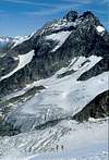
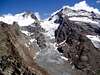
Lagginhorn is the most North-Easterly and lowest fourthousand-meter peak of the Walliser Alps. The summit soars small and airy over deep abysses. According to the SPer Mathias Zehring, Lagginhorn is perhaps the only 4.000 m mountain of the Alps that can be climbed without crampons and danger of crevasses, and (as no bigger climbing skills are necessary) even a hiker could reach the summit if the upper part is free of snow. Most of the easiest route is a steep path in very loose scree interrupted by short steps that need a little climbing. For a trained climber a good recommendation is doing the traverse from Fletschhorn.
It's formed by:
West Ridge - Normal Route PD, II
North Ridge AD, III
East Spur AD+, III
South Ridge AD, II / III
First ascent (starting at Trifalp, 2.072 m): Johann Joseph Imseng, Franz Joseph Andenmatten, Edward Levi Ames, 3 English and 3 guides on 26 August 1856.
Because you can avoid the glaciers you don't have to start too early. The climb goes into the west face so it takes some time before you meet the sun and a nicer temperature. When you stay for 2 days you also can climb the neighbour Weissmies. Both peaks are ideal for acclimatisation when you want to climb the higher peak in the valley.
 |
 |
 |
 |
 |
Timetable
4-5 hours from Weissmieshütte
3-4 hours from Hohsaas
45 min from Hohsaas to Weissmieshütte
45 min Kreuzboden to Weissmieshütte
4 hours from Simplon Dorff to Bivouac Laggin
 |
Getting There
First you should reach Saas Grund in the Walliser Saastal. Then hike to Weissmieshütte (2.726 m) or cableway to Hohsaas (3.098 m). Cableway's lowest station is in Unter dem Berg, a quarter of Saas Grund. Mid station is Kreuzboden (2.397 m).
 |
 |
 |
Red Tape
Free to climb yet.
When To Climb
From June to September is the best period for climbing this mountain. Live-cam from Kreuzboden
Camping
A lot of campings and hotels in Saastal (Saas Balen-Saas Grund-Saas Fee-Saas Almagell).
HUTS
Weissmieshütte (2.726 m)
CAS, 110 places, opens from mid June to the end of September, winter from 15 December to 15 April. Phone: 0041 (0) 28 57 25 54
Berghaus Hohsaas (3.100 m)
Private, 36 places, opens from mid June to mid October. Phone: (00) (41) 27 957 17 13. Another possible number: 077 28 41 79
Laggin Biwak (2.425 m)
CAS, 10 places, always open
 |
 |
 |
 |
Maps
Simplon, Landeskarte der Schweiz, 1:25.000.
5006 Matterhorn-Mischabel, Landeskarte der Schweiz, 1:50.000.
Berg: Lagginhorn
External Links
- Saas Grund site
Weather, accomodations, etc... - Weissmieshütten
The site of these huts, in German. - Lagginhorn at www.4000er.de
Images, routes, coordinates and more information about the highest peaks of the Alps
Diego Sahagún - Jul 25, 2002 9:16 am - Hasn't voted
Untitled CommentMy information is: South Ridge (AD, II / III , mixed, brittle to start with, 5 hours from Hohsaas via Lagginjoch).
philippe - Jul 24, 2002 11:55 pm - Voted 10/10
Untitled CommentThe South Ridge AD, III / IV is a very interesting climbing variant for the Lagginhorn. Start at Hohsaas station for a 7 hours trip up to the top.
Diego Sahagún - Jul 25, 2002 9:16 am - Hasn't voted
Untitled CommentMy information is: South Ridge (AD, II / III , mixed, brittle to start with, 5 hours from Hohsaas via Lagginjoch).
Garfield - Dec 12, 2005 9:59 am - Hasn't voted
Untitled CommentPhoto