-
 23746 Hits
-
 91.13% Score
-
 34 Votes
|
|
Mountain/Rock |
|---|---|
|
|
44.11443°N / 113.6705°W |
|
|
Custer |
|
|
Hiking, Mountaineering, Mixed, Scrambling |
|
|
Spring, Summer, Fall |
|
|
11857 ft / 3614 m |
|
|
Overview

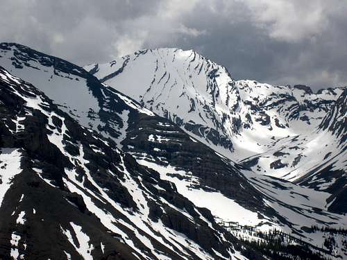
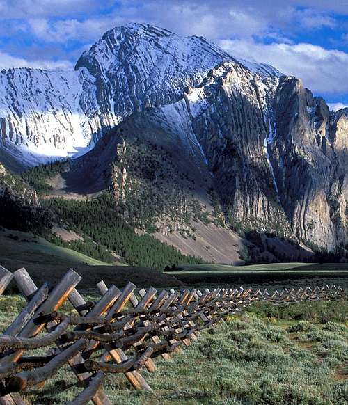
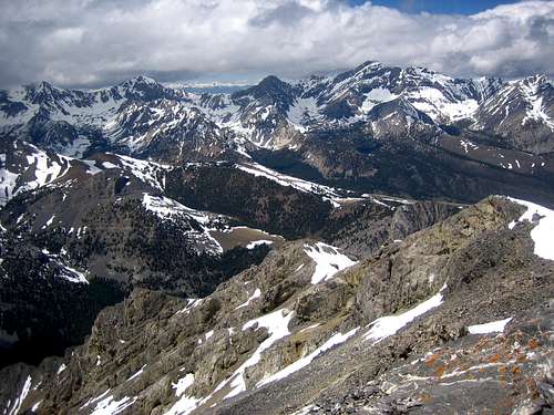
Nearby Mount Breitenbach sits just 3 miles south of Corruption and Borah Peak , Idaho's tallest, lies 5.7 to the northwest. These peaks are typically accessed from the Lost River Valley and the ID-93 corridor. Mount Corruption's approach involves crossing over from the Lost River Valley, just north of Borah, into the Pahsimeroi Valley with at least 25 miles of variable dirt road.
Mount Corruption's name derives not from a corrupted historical mining company in the area, nor a corrupt congressmen, but simply from the quality of rock on the peak. Nearby Bad Rock Peak is unofficially named in similar fashion. The Lost River Range contains one of the greatest collections of impressive unnamed peaks. Some notable unofficially named peaks include: Mount Idaho (12,065), Sacajawea Peak (11,936), Mount Corruption (11,857), Mount Church (12,200), No Regret Peak (11,972), Lost River Mountain (12,078), USGS Peak (11,982). You'll notice that 3 of Idaho's 12ers do not have official names. There are over 50 peaks in the Lost River Range that rise from 10,000 to 12,000+ feet with no official name.
Trails / Routes
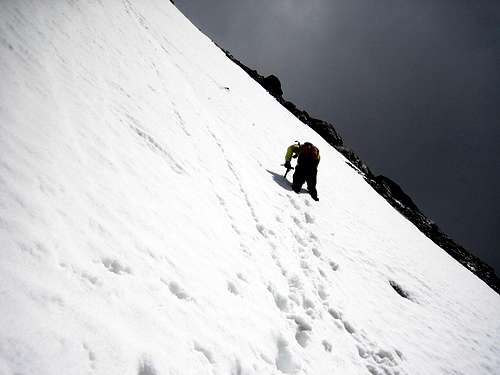
- North-North West Side Couloirs- 2 distinct couloirs rise on the north side of Corruption and are easily viewed while approaching via the East Fork of the Pahsimeroi River. The couloir on the right side (if viewed from the north) rises at a steeper angle and for a longer distance than the couloir on the left side. The left couloir rises approximately 1500 feet until it meets a lower shoulder ridge of the peak. The right side couloir rises approximately 2000 feet until it crests on the ridge. The longer couloir rises for only about 50% of the elevation of the peak as measured from the valley floor. This means that topping out on the couloir still leaves half the climb to get to the summit of Corruption. From the lower ridge scamble southwest, then southeast as it approaches the summit. Near the top there are short sections of Class 4 climbing. Descend via the SW Face Route for a very quick retreat.
- Southwest Face-See Routes for more info.
Numerous other possibilities exist starting on the north side valley and the West Fork of the Burnt Creek.
Maps: USGS Burnt Creek NE, USGS Leatherman Peak, USGS Rabbit Creek Summit, 1:100,000 Borah Peak
Getting There

From ID-93 turn off east onto DoubleSprings Pass Road at approximately 46 miles north of Arco. It will be approximately 25 miles to the trailhead from this turn off. Leave the DoubleSprings Pass at 9.5 miles with a hard right turn. Proceed on the most traveled road up and over HorseHeaven Pass and descend into Mahogany Creek (signed). Cross the stream (1 of 4 ) which may be several feet deep and ascend to the ridge. At approximately 13.9 from the DoubleSprings Pass Road turnoff you'll encounter a split. The right hand split ascends the West Fork of the Pahsimeroi River Valley. You'll take the left fork up the East Fork of the Pahsimeroi River Valley. Follow this road to the complete end for the SW Face route and stop under the north-northwest couloirs for those routes.
4WD is required for the spring creek crossings, short steep hills, and large rocks in the dirt roads.
Scrambling Approach
For the SW Face: Park as high up into the East Fork valley that you can and stay close and just above the river on the east side. Look for a small forested area that rises slightly into the SW Face (visible on the USGS map). Follow the tree band as high as it will go and then enter the scree field. Follow the few solid sections of limestone and angle slightly left as you rise up. Just under the summit you angle back to the right under a cliff band on the ridge and ideally exit at a small notch where you'll walk just east and south a few hundred feet to the true summit.
For the North-Northwest Couloirs: From approximately 8200 feet pick your way up through pines and small cliff bands until your just under the couloir.
Conditions and Season
Contact Info:
Lost River Ranger District
P.O. Box 507
716 W Custer
Mackay, Idaho 83251
(208) 588-3400
email: rerickson@fs.fed.us
Office Hours: Monday - Friday 8:00 am - 4:30 pm
Primitive camping can be found virtually anywhere.
Nearby Mackay, Idaho Climate Data:
| Jan | Feb | Mar | Apr | May | Jun | Jul | Aug | Sep | Oct | Nov | Dec | Annual | |
| Average Max. Temperature (F) | 29.2 | 34.2 | 43.0 | 55.2 | 65.2 | 74.1 | 84.1 | 82.7 | 73.3 | 60.1 | 42.1 | 31.3 | 56.2 |
| Average Min. Temperature (F) | 5.6 | 10.1 | 18.9 | 28.1 | 35.9 | 42.3 | 48.4 | 46.3 | 38.3 | 30.0 | 18.7 | 8.9 | 27.6 |
| Average Total Precipitation (in.) | 0.78 | 0.61 | 0.61 | 0.68 | 1.09 | 1.34 | 0.93 | 0.80 | 0.67 | 0.57 | 0.59 | 0.78 | 9.43 |
| Average Total SnowFall (in.) | 7.5 | 5.9 | 2.4 | 0.5 | 0.1 | 0.0 | 0.0 | 0.0 | 0.1 | 0.2 | 2.0 | 7.3 | 26.1 |
| Average Snow Depth (in.) | 5 | 4 | 1 | 0 | 0 | 0 | 0 | 0 | 0 | 0 | 0 | 3 | 1 |