
-
 1146 Hits
-
 79.04% Score
-
 10 Votes
|
|
Route |
|---|---|
|
|
45.68410°N / 7.40710°E |
|
|
Hiking |
|
|
E/F |
|
|
Overview
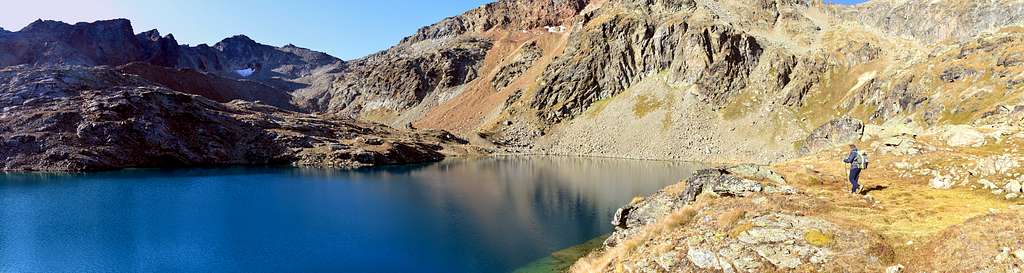
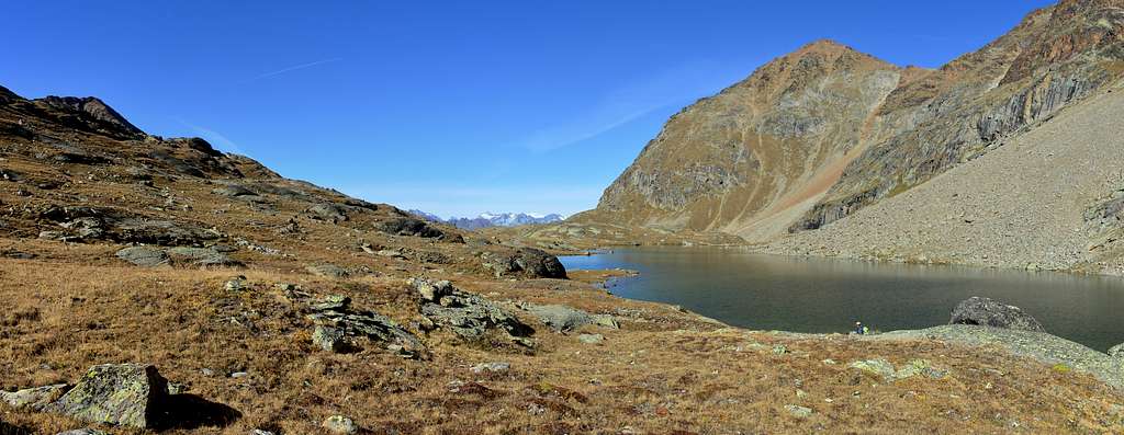
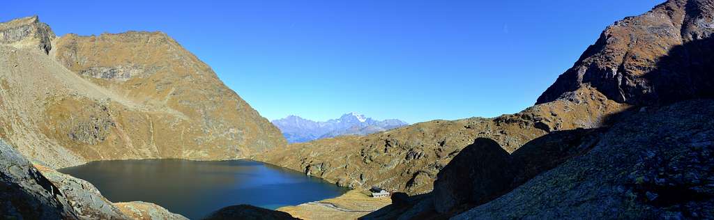
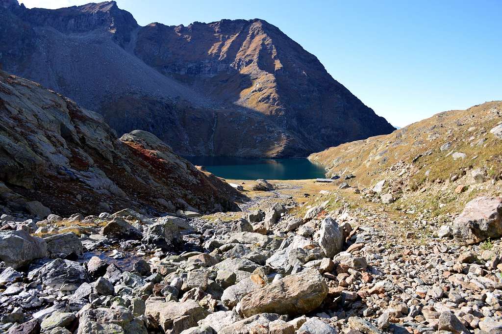
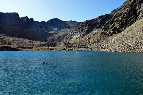
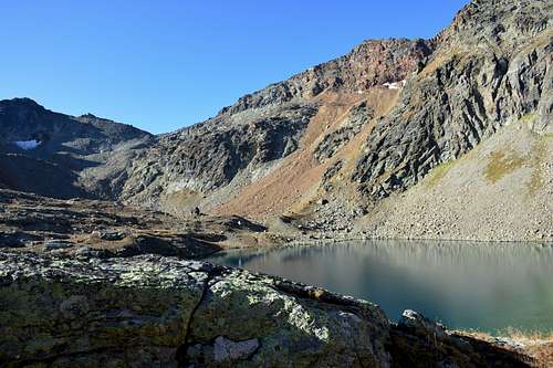
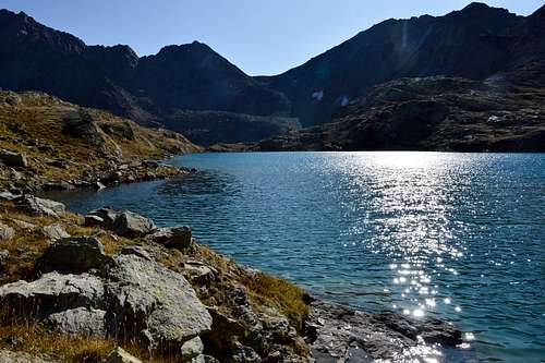
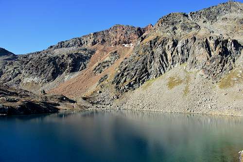
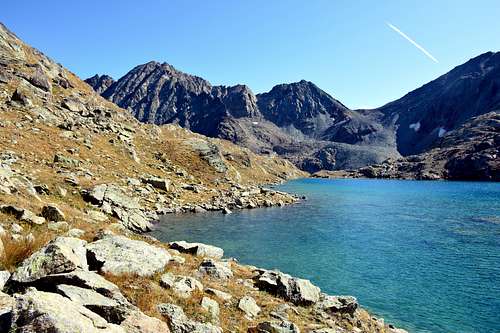
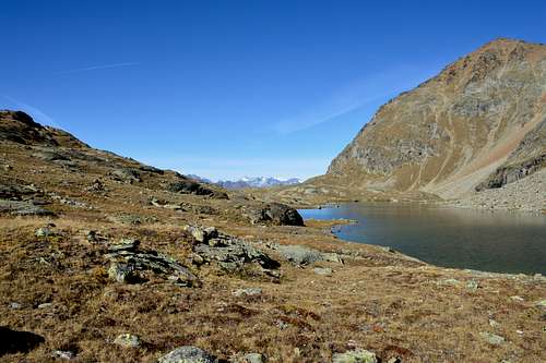
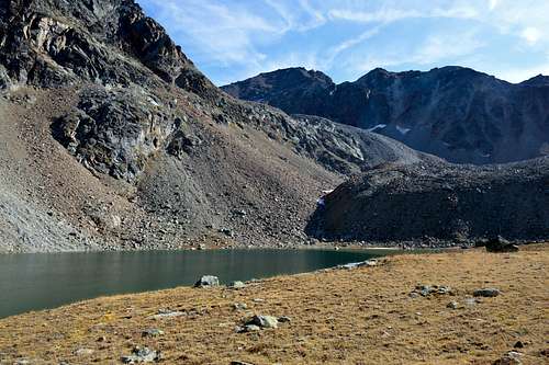
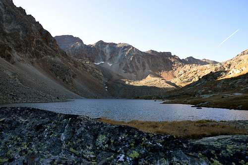
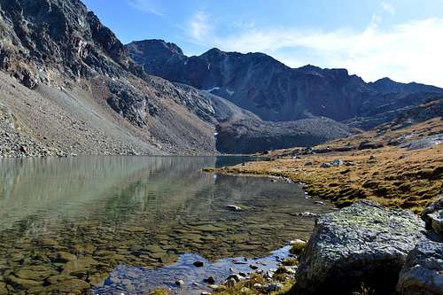
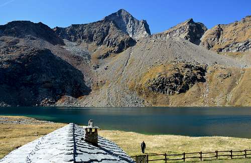
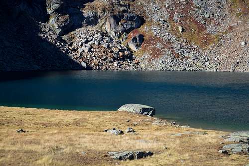
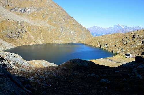
To say which is the most beautiful lake in the Aosta Valley is improbable if not impossible. But affirming which is the most magnificent grouping of lakes is simple: certainly that of the Laures within the long and deep valley of the same name, above the town or Municipality of Grand Brissogne. It does not fear competition from the lakes below the Mont Glacier with the Gran Lago in the lead and not even that with the Palasina Lochs grouping above Estoul Hamlet (Brusson) in Val d'Ayas. Three splendid emerald lakes peek between the Roises or Roèses Mountain Chain to the East as well as over the elongated South / North Lac Long (2.630m) and the imposing pyramid of the Emilius (3.559m) to the West which showcases its vertical East Wall of 500 meters, above the Glacier de Blanchet or Blantsette in turn located above Lac Dessous (2.544m), with the related Ernesto Menabreaz Refuge nearby (2.546m), owned by the Brissogne hunters. A third lake or Lac Dessus or Lac-d'en-Haut (2.787m) is located at the foot of the Pointe des Trois Capucins (3.283m) between the Colle di Arbole " (3.154m) just to the South and the "Pas des Trois Capucins" (3.242m) in North, on the fourfold road that also leads from the Laures Vallon in South to the Col des Laures (3.035m) and to the East towards Leppe's Pass (3.110m). It is a real corner of Paradise, certainly loved and sought after by lovers of great silences ...
Dire quale sia il più bel lago della Valle d'Aosta risulta cosa improba se non addirittura impossibile. Ma affermare quale sia il più magnifico raggruppamento di laghi é cosa semplice: sicuramente quello delle Laures all'interno del lungo e profondo omonimo vallone, al di sopra dell'abitato o Comune di Grand Brissogne. Non teme la concorrenza dei laghi sottostanti al Mont Glacier con in testa il Gran Lago e neppure quella con il raggruppamento dei Laghi di Palasina sopra il Villaggio di Estoul (Brusson) in Val d'Ayas. Tre splendidi laghi color smeraldo occhieggiano tra la Catena delle Roises o Roèses ad Oriente nonché al di sopra dell'allungato Sud/Nord Lac Long (2.630 m) e l'imponente piramide dell'Emilius (3.559 m) ad Occidente che mette in mostra la sua verticale Parete Est di 500 metri, al di sopra del Glacier de Blanchet oppure Blantsette a sua volta collocato sopra il Lac Dessous (2.544 m), con vicino il relativo Rifugio Ernesto Menabreaz (2.546 m), di proprietà dei cacciatori di Brissogne. Un terzo lago o Lac Dessus oppure Lac-d'en-Haut (2.787 m) é posizionato alle falde della Pointe des Trois Capucins (3.283 m) tra il Colle di Arbole (3.154 m) appena a Meridione ed il "Pas des Trois Capucins" (3.242 m) a Settentrione, sulla quadruplice via che dalle Laures conduce dale Laures anche ai Colli di Laures (3.035 m) a Sud e di Leppe (3.110 m) verso Oriente. Risulta vero e proprio angolo di Paradiso, sicuramente amato e ricercato dagli amanti dei grandi silenzi ...
Getting There
BY CAR: From Torino, Milano, etc: Motorway A5. Exit at Aosta Est. From Switzerland: through the Grand Saint Bernard Tunnel or the namesake Pass. Drive to Aosta. From France: through Mont Blanc Tunnel or Petit Saint Bernard Pass. It isn't necessary to take Motorway A5: you can drive on SS.26, in the direction of Aosta.
Roads Route
Specific Road: from Exit out of Motorway A5 continue on SS.26) - to "rotonda" or roudabout of St. Marcel; crossing on great bridge the Dora Baltea reach the center of Municipality; continue South on Regional Road to Les Druges Lower and Highest (brown signal to Servette-Chuc Coppermines and Turati Reserve).
Also 2) - continue on State Road up to the Quart-Villefranche Commune; from this turn left (South) and toward a second great bridge above Dora Baltea reach an alternative. Leaving right (West) the Regional Road to Pollein/Charvensod Communes and just after abandoning East various secondaries deviations to St. Marcel Commune, go up a small hill and continue before to the South; crossing Laures Torrent on small bridge, after continue West to Grand Brissogne Municipality.
Strada Specifica: dall'uscita dell'Autostrada A5 proseguire su SS.26) - alla rotonda di SaintMarcel; attraversando sul grande ponte la Dora Baltea si raggiunge il centro dell'omonimo Comune; proseguire verso sud sulla strada regionale per gli Alpeggi di Les Druges Basse ed Alte (segnale marrone per Servette-Chuc Coppermines e Riserva Turati).
Anche 2) - proseguire su Strada Statale fino al Comune di Quart-Villefranche; da questa svoltare a sinistra (Sud) e verso un secondo grande ponte sopra la Dora Baltea raggiungere un bivio. Lasciando a destra (Ovest) la Strada Regionale per i Comuni di Pollein / Charvensod e subito dopo aver abbandonato ad Est varie deviazioni secondarie per il Comune di St. Marcel, si risale un piccolo colle e si prosegue prima verso Sud; attraversando il torrente Laures su un ponticello per poi proseguire verso Ovest fino al Comune di Grand Brissogne.
 |
 |
 |
 |
 |
Approach & route
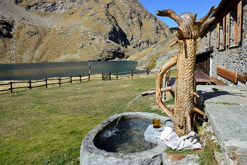
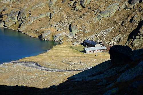
Approach From the underlying Grand Brissogne Municipality (894m), go along the private dirt farms road till the isolated Gramonenche Pasture (prohibition to unauthorized vehicles with a sign at the hairpin bend at about 1.010/20 meters just before a farm). From here, always along the same reach the l'Arp (1.310m) then, along a good path-muletrack that, bordering the Laures Torrent, leads to La Vieille (1.623m) and to the following Le Tramail or Tramouail (1.951m) (good shelter when weather is bad; always open). Crossing some small bridges up to the altitude of 2.200m, (starting from this point a steep but faster path goes, at right or West, toward the slopes of Becca di Seneva, which then climbs the narrow and small valley at the foot of the same rejoining higher with the muletrack). Better go on toward E forwarding the Becca di Salè (Black Fountains) and climb the last 400 meters on wide slopes till the top of the terraces (2.600m) (here a small chapel built in 1930 and dedicated to Charrey brothers Alessandro said "Dino" and Jean and to companion Cino Norat dead in August 25th, 1929 in an attempt to win the still unclimbed East Wall of Monte Emilius). A short descent leads to the Refuge Ernesto Menabreaz (2.542m, private; has an open free part with blankets, stove and various victuals; usable as winter room, better bring with you a little bit of wood; 8 places), on the Eastern bank of Dessous (Lower) Laures Lake, just neighbor the effluent (small wooden footbridge to Peckoz Pass through path in West).
IIMPORTANT REMARK: then you shouldn't forgetting the fact that all the climbs in this long and deep vallon require a long and exhausting descent to Grand Brissogne; the problem of fatigue becomes even greater if you want to make the ascent in one day sewnza overnight on the Menabreaz Refuge. And yet, when the bad weather comes on the way up to the last, perhaps with fog or snowing so visibility is poor, it is convenient, especially to those not familiar with the area, stopping at Tramouail Upper Alpage even at the preceding La Vieille Pasture. "On route to the Laures Valley"Gremonenche.
 |
 |
 |
 |
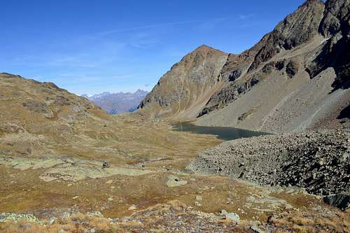 |
Dal sottostante Comune di Grand Brissogne (894 m) continuare sulla strada poderale per l'Alpeggio isolato di Gramonenche (divieto ai mezzi non autorizzati con cartello al tornante a gomito a circa 1.010/20 metri appena prima di una fattoria). Da qui, tramite la medesima, raggiungere l'Arp (1.310 m); quindi tramite un bel sentiero mulattiera, accompagnando il corso del Torrent des Laures, risalire a La Vieille (1.623 m) ed al successivo Le Tramail o Tramouail (1.951 m) (ottimo riparo, sempre aperto, in caso di maltempo). Attraversando varii ponticelli fino alla quota di 2.200 metri, (da questo punto risale un sentiero "ripido ma più rapido" verso destra od Ovest verso i pendii della Becca di Seneva, che poi risale l'angusto valloncello ai piedi della medesima ricongiungendosi più in alto con la mulattiera). Meglio proseguire più ad Oriente in direzione delle alte pareti della Becca di Salè (località detta in loco delle Fontane Nere) e risalire gli ultimi 400 metri su ampi pendii fino al colmo dei terrazzamenti rocciosi soprastanti (circa 2.600 metri; dove è stata costruita nel 1930 una piccola cappella dedicata ai fratelli Alessandro detto "Dino" e Jean Charrey ed a Cino Norat morti il 25 di Agosto del 1929 nel tentativo di vincere l'ancora inviolata Parete Est del Monte Emilius). Una breve discesa su sentierucolo in diagonale conduce all'Ernesto Menabreaz (2.542 m, privato ma con una parte libera sempre aperta con coperte, stufa e vettovaglie varie; utilizzabile come riparo d'inverno; 8 posti letto), sulla sponda Est del Lago Inferiore delle Laures.
NOTA IMPORTANTE: non si deve poi trascurare poi il fatto che tutte le salite in questo lungo nonché profondo vallone richiedono lunga ed estenuante discesa fino a Brissogne; la problematica della fatica diventa ancor maggiore qualora si volesse fare la gita in un'unica giornata senza relativo pernottamento. Ed ancora, qualora il brutto tempo arrivasse durante la salita a quest'ultimo, magari con nebbia oppure nevicando e quindi con scarsa visibilità, conviene, soprattutto a chi non é conoscitore della zona, fermarsi al Tramouail se non addirittura a La Vieille.
 |
 |
 |
 |
 |
Essential Gear
Hiking gear.
Da escursionismo.
External Links
- Pila web-site Pila, the famous winter station, has an active life even in summertime. In this link, you'll able to find time schedule for Chamolè Chair Lift.
- REGIONE AUTONOMA VALLE D'AOSTA the official site.
- FONDAZIONE MONTAGNA SICURA Villa Cameron, località Villard de la Palud n° 1 Courmayeur (AO) Tel: 39 0165 897602 - Fax: 39 0165 897647.
- A.I.NE.VA. (Associazione Interregionale Neve e Valanghe).
Useful numbers
- Protezione Civile Valdostana località Aeroporto n° 7/A Saint Christophe (Ao) Tel. 0165-238222.
- Bollettino Valanghe Tel. 0165-776300.
- Bollettino Meteo Tel. 0165-44113.
- Unità Operativa di Soccorso Sanitario Tel. 118.