
-
 2677 Hits
-
 81.18% Score
-
 13 Votes
|
|
Route |
|---|---|
|
|
45.59568°N / 7.25654°E |
|
|
PAGE UNDER MAINTENANCE
Overview
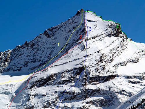
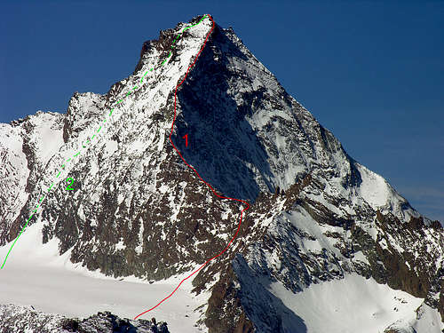
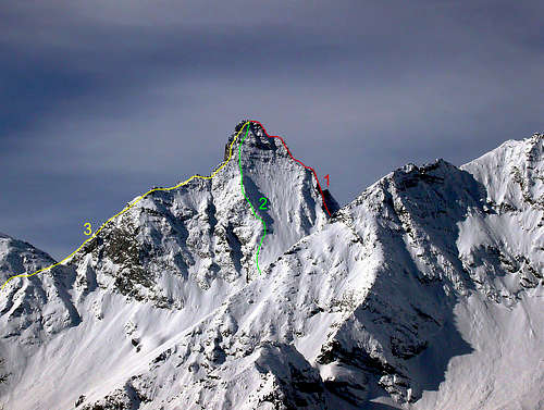
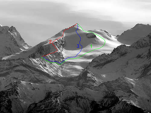
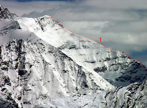
The subgroup of La Grivola, or also Mont-Grivola (3.969m) is complementary to the North-northwest with respect to the main one of the Gran Paradiso (4.061m), which in turn gives birth to a long crest dividing the Valleys of Cogne (to the East) and of Valsavarenche. This buttress ends at Colle Lauzon or Loson (3.296m), where that of Grivola begins. This last one, formed some secondary elevations (Becca de Vermiana, Col des Rayes Noires, Punta Bianca, Col du Mont Grivola, Pointe Tuckett) reaches the same La Grivola through its steep South-southwest Ridge, characterized by a vertical yellowish jump. Two parallel ridges descend from the summit which contain the Belleface Glaciers to the Northwest and Mont Grivola to the North-Northeast. The first flanks a ridge that descends to the Col de Belleface (3.095m) to rise up to the black and jagged pyramid of the Grand Nomenon (3.488m, as beautiful and attractive as it is rarely visited) before continuing towards the Central Valley of the Dora Baltea forming various minor elevations (Col Charbonnière, Mont Favret or, among the local inhabitants, also known as Ruje, Pointe Valletta, Col de Becca Plana and Becca Plana and, lastly, Mont-de-Poignon just above the Hamlet of Pondel or Pont's d'Ael' Village. On the opposite side the partition with Cogne ends above the Fraction or Hamlet of Epinel, after having formed several points: Mont-Grivoletta, Crête Giacosa, Pointe Crevasse, Col duTrayo, Pointe du Trayo or Trajo and also Tradzo , Pointe de Lavincusse, Côte de Lavincusse. Between these two sturdy buttresses, a fascinating comma-shaped crest descends to divide the two aforementioned glaciers, which mountaineers know as "The Scimitar" much to traveled in the past, it has now fallen into disuse; while the concomitant Northwest and Northeast Walls remain in vogue, already descended through extreme skiing. Returning back to the Punta Bianca or Pointe Blanche (3.793m), a large and imposing shoulder that gives birth to the Glacier du Trazo or Tradzo towards the northwest, to note a series of satellites that are configured with the Punta and the Colle della Nera (3.683m, 3.487m) , the Pointe Rousse or Punta Rossa (3.630m), the Col Pousset near the Gratton Bivouac (3.201m, 3.198m) followed by the elegant Pointe or Punta del Pousset (+; 3.045m) which dominates the main Municipality of Cogne (1.534m, 1.545m) from the West.
Il bel Sottogruppo de La Grivola, od anche Mont-Grivola (3.969 m) é complementare a Nord-nordovest rispetto a quello principale del Gran Paradiso (4.061 m), che a sua volta partorisce una lunga cresta divisoria le Valli di Cogne (ad Est) e di Valsavarenche. Tale contrafforte si esaurisce al Colle Lauzon o Loson (3.296 m), dove inizia quello della Grivola. Questo ultimo, formate alcune elevazioni secondarie (Becca de Vermiana, Col des Rayes Noires, Punta Bianca, Col du Mont Grivola, Pointe Tuckett) raggiunge La Grivola tramite le sua ripida Cresta Sud-sudovest, caratterizzata da un verticale salto giallastro. Dalla vetta scendono due creste parallele che contengono i Ghiacciai de Belleface a Nordovest e du Mont Grivola a Nord-nordest. Il primo affianca un crestone che scende al Col de Belleface (3.095 m) per rialzarsi alla nera e frastagliata piramide del Grand Nomenon (3.488 m, tanto bella ed attraente quanto raramente frequentata) prima di proseguire in direzione della Valle Centrale della Dora Baltea formando varie elevazioni di minor importanza (Col Charbonnière, Mont Favret o, tra gli abitanti locali, noto anche come Ruje, Pointe Valletta, Col de Becca Plana e Becca Plana nonché, da ultimo, Mont-de-Poignon giusto al di sopra dell'abitato di Pondel oppure Pont d'Ael. Sul lato opposto il divisorio con Cogne si conclude sopra la Frazione di Epinel, dopo aver formato diverse punte: Mont-Grivoletta, Crête Giacosa, Pointe Crevasse, Col duTrayo, Pointe du Trayo o Trajo ed anche Tradzo, Pointe de Lavincusse, Côte de Lavincusse. In mezzo a questi due robusti contrafforti, scende a dividere i due predetti ghiacciai un affascinante cresta a forma di virgola che gli alpinisti, appunto, conoscono come "La Scimitarra". Alquanto percorsa nel passato, ormai é caduta in disuso; mentre rimangono in auge le concomitanti Pareti Nordovest e Nordest, ormai già discese tramite lo sci estremo. Ritornando indietro alla Punta Bianca o Pointe Blanche (3.793 m), grande spallone che partorisce verso Nordovest il Glacier du Trazo o Tradzo, da annotare una serie di satelliti che si configurano con la Punta ed il Colle della Nera (3.683 m, 3.487 m), la Pointe Rousse o Punta Rossa (3.630 m), il Col Pousset presso il Bivacco Gratton (3.201 m, 3.198 m) seguiti dall'elegante Pointe o Punta del Pousset (+; 3.045 m) che da Occidente domina il principale abitato del Comune di Cogne (1534 m, 1.545 m).
Fist Ascents
La Grivola (3.969m)
- First on the Summit: J. Ormsby, R. Bruce, Fidèle-Ambroise Dayné, Z. Cachat and J. Tairraz (Aug 23th,1859).
Grand Nomenon (3.488m)
- First on the Summit: F. Montaldo, A. Boggiatto and Antonio Castagneri, (Jun 25th, 1877).
Punta Rossa della Grivola (3.630m)
- First on the Summit: H. de F. Montgomery, S. Taylor and J. Tannler, (1864).
Punta Nera della Grivola (3.683m)
- First on the Summit: W. A. B. Coolidge, G. Yeld, Chr. Jun. and R. Almer, (Aug 08th, 1888).
Punta Bianca della Grivola (3.793m)
- First on the Summit: P. B. Chamonin and A. J. Jantet, (Sep 21th, 1858).
Route Description

Essential Gear
Complete alpine equipment.
Attrezzatura alpinistica completa.
Refuges and Bivouacs
Rifugio VITTORIO SELLA (2.588m) Valle di Cogne Valnoney
Books and Maps
BOOKS:
- "Guida dei Monti d'Italia-Gran Paradiso Parco Nazionale" E. Andreis, R. Chabod, M. C. Santis, Club Alpino Italiano/Touring Club Italiano, prima Ed. 1939; seconda Ed. 1963; terza Ed. 1980.
- "Guida delle Alpi Occidentali", di Giovanni Bobba e Luigi Vaccarone C.A.I. Sezione di Torino Volume II (parte II), 25 Maggio 1896.
- "Il Parco Nazionale del Gran Paradiso" di G. Berruto, volume 2° Ed. I.G.C. Torino 1981, 2000.
- "80 itinerari di Escursionismo Alpinismo e Sci Alpinismo in Valle d'Aosta", di Osvaldo Cardellina, Ed. Musumeci, Giugno 1977 (in Italian); seconda Ed. Luglio 1981; terza Ed. Luglio 1984; (in French), prima Ed. Febbraio 1978; seconda Ed. Marzo 1980.
- "Gran Paradiso" A. Gegenfurtner, G. Klotz, F. Müller, Ed. Bergverlag Rudolf Rother, Monaco 1980 (in tedesco).
- "Gran Paradiso" G. Klotz Ed. Bergverlag GmbH Rother, Monaco 2005 (in tedesco).
- "Rifugi e bivacchi in Valle d'Aosta", di Cosimo Zappelli aggiornata da Pietro Giglio, Musumeci Editore, Luglio 2002.
- "Diari Alpinistici" di Osvaldo Cardellina e Indice Generale accompagnato da Schedario Relazioni Ascensioni 1964-2019 (inediti).
 |
 |
 |
 |
 |
MAPS:
- Kompass "Gran Paradiso Valle d'Aosta" Sentieri e rifugi-Carta turistica 1:50.000.
- I.G.C. Istituto Geografico Centrale "Gran Paradiso La Grivola Cogne" Carta 1:25.000.
- I.G.C. Istituto Geografico Centrale "Il Parco Nazionale del Gran Paradiso" 1:50.000.
- I.G.M. Istituto Geografico Militare Foglio 41 "Gran Paradiso-Cogne" 1:25.000.
- AIAT Cogne "Gran Paradiso" Cogne Aymavilles-Walking map 1:25.000.
- Enrico Editore Ivrea "Gruppo del Gran Paradiso" 1:50.000.
- Studio F.M.B. Bologna "Gran Paradiso" 1:50.000.
- L'Escursionista "Valle di Cogne Carta dei Sentieri" (n° 10) 1:25.000.
- L'Escursionista "Tour de la Vallée de Cogne Grand Paradis" Carta dei sentieri 1:25.000.
Acknowledgements
The fundamental support given by my friend "Osva" for the "Overview" with translation.